
Rivers
Park geography
Structured landscape analysis including regional coordinates and physical terrain features
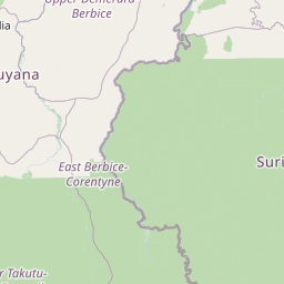
Geographic Profile and Mapped Boundaries of Central Suriname Nature Reserve in Suriname
Analyze the precise geographic layout and environmental composition of Central Suriname Nature Reserve, located within the Sipaliwini District. This profile details the protected area boundaries, covering approximately 16,000 square kilometers, and records key terrain elements such as the Tafelberg, Julianatop, and the Wilhelmina Mountains.
Related tags
tropical rainforestUNESCO World Heritage Sitegranite domesGuianan moist forestsprimary forest
Pristine Guianan rainforest preserve protecting Suriname's highest mountains and granite dome wilderness
Central Suriname Nature Reserve
The Central Suriname Nature Reserve is a vast protected area in the heart of Suriname's interior, encompassing approximately 1.6 million hectares of untouched tropical rainforest in the Sipaliwini District. Established in 1998 through the merger of three existing reserves—Ralleighvallen, Tafelberg, and Eilerts de Haan gebergte—the reserve represents one of the largest continuous tracts of pristine Guianan moist forest in the world. The reserve was designated a UNESCO World Heritage Site in 2000 recognizing its exceptional ecological significance as a living laboratory of tropical biodiversity. The landscape features dramatic granite domes rising sharply above the canopy, including the iconic Voltzberg at 245 meters, while the Julianatop reaches 1,230 meters as Suriname's highest peak. The area remains in remarkably pristine condition, serving as a critical refuge for species including jaguars, giant armadillos, and eight primate species.
- Location
- Suriname
- Park type
- Nature reserve
- Established
- 1998
- Area
- 16,000 km²
- Highest point
- 1,230 m
Location overview
Regional placement inside the Sipaliwini District of Suriname
Central Suriname Nature Reserve Geographic Setting and Regional Mapping
The interior reserve sits entirely within the Sipaliwini District of Suriname. The protected area operates under single-country jurisdiction with no coastal or transboundary borders.
- Countries
- Suriname
- Regions
- Sipaliwini District
- Primary location
- Sipaliwini District
- Geographic setting
- Inland
Boundary and coordinates
Charting the spatial extent and boundary measurements of the protected reserve
Central Suriname Nature Reserve Boundary Map and Spatial Dimensions
Visualizing the mapped perimeter of the reserve offers clear spatial context for its vast tropical interior. Geographic data points detail the estimated sixteen thousand square kilometer area, coordinates, and center point.
- Boundary area
- 16,164.4 km²
- Boundary perimeter
- 647.2 km
- Northernmost point
- 4.8783° N
- Southernmost point
- 2.973° N
- Easternmost point
- 55.8387° W
- Westernmost point
- 57.0903° W
- Geographic centre
- 3.9459° N, 56.3868° W
- North–south span
- 210.7 km
- East–west span
- 139 km
Elevation and terrain
Mixed relief profiles and recorded peaks, rivers, and ranges
Central Suriname Nature Reserve Terrain and Elevation Summary
Explore the recorded elevation summary reaching up to 1,230 meters across mixed terrain classifications within the protected landscape. Detailed feature cards provide names, types, measurements, and spatial relationships for peaks and waterways located throughout the reserve.
- Maximum elevation
- 1,230 m
- Highest point
- 1,230 m
Selected named natural features
Peaks
Emma Keten
Rivers
Zondag kreek
Rivers
Toeko kreek
Peaks
Tafelberg
1,060 m
Peaks
Julianatop
1,230 m
Environmental setting
Tropical forest cover, mountainous relief, and river systems across the reserve
Central Suriname Nature Reserve Environmental Settings and Landscape Classifications
Stored classifications provide complementary frameworks for reading the physical setting of Central Suriname Nature Reserve. Recorded categories link directly to related environmental destinations within the broader park atlas.
- Relief
- Mixed relief
- Climate
- Tropical
- Water
- Major water bodies
- Forest cover
- Dense forest cover
Landscape features
Mountains · Plateau · Cliffs · Forest · Rivers
Habitat types
Tropical forest · Montane forest
Park atlas
Compare the diverse protected landscapes of Suriname and the Guianas, tracing regional conservation efforts.
Explore Other National Parks and Protected Areas Near Central Suriname Nature Reserve
Explore additional national parks and protected areas in the region surrounding Central Suriname Nature Reserve, offering further insight into the diverse Guianan moist forests and unique granite dome landscapes. Compare these vital conservation zones to trace broader protected-area geography and understand regional ecological connections.
National parkSuriname
About 84 km away#1 closest
Northeast

Brownsberg Nature Park: Suriname National Park with Tropical Forest and Waterfall Landscapes
Mapped geography and protected landscape context.
Brownsberg Nature Park stands as a vital protected landscape within Suriname, distinguished by its central mountain, tropical forest ecosystems, and scenic waterfalls such as Leo Waterfall. The park's location overlooking the vast Brokopondo Reservoir provides a unique geographic setting, making it an important destination for atlas and map-based exploration of Suriname's natural heritage. Understanding Brownsberg Nature Park offers insight into the Neotropical biodiversity and terrain characteristic of the Guianan moist forests.
- Area
- 122 km²
- Established
- 1969
- IUCN
- II
- Visitors
- 20K annual
National parkFrench Guiana
187 km away#2 closest
Southeast

Guiana Amazonian Park National Park: French Guiana's Expansive Protected Rainforest
Explore mapped boundaries and regional geographic context.
Guiana Amazonian Park, a cornerstone of protected land in French Guiana, offers a profound exploration of untamed Amazonian rainforest. As the largest national park in the European Union, it showcases a vast, remote ecosystem characterized by towering trees and intricate river systems. This page provides detailed context on its geographic placement within French Guiana and its significance as a major protected landscape for atlas-based discovery and understanding of tropical forest conservation.
- Area
- 20,300 km²
- Established
- 2007
- IUCN
- II
- Relief
- Lowland
Nature reserveFrench Guiana
About 248 km away#3 closest
Northeast
Amana Nature Reserve Nature Reserve: French Guiana's Mapped Protected Landscape
Explore the geographic context and protected area identity.
Amana Nature Reserve is a vital protected area situated in French Guiana, a region renowned for its extensive tropical rainforests. As a nature reserve, it contributes significantly to the atlas of protected lands in South America, offering a distinct geographic identity. Understanding Amana Nature Reserve involves exploring its mapped boundaries and its place within the unique natural terrain of the Guianas, providing essential context for geographic discovery.
- Area
- 148 km²
- Established
- 1998
- IUCN
- IV
- Relief
- Lowland
Protected areaGuyana
About 277 km away#4 closest
Southwest

Kanashen Protected Area: Geographic Identity and Mapped Boundaries in Guyana
Explore the mapped landscape and protected land context.
Kanashen Protected Area serves as a critical point of geographic discovery within Guyana, offering detailed insights into its protected boundaries and natural landscape. This entry focuses on providing a structured, atlas-driven understanding of Kanashen, emphasizing its role within the regional geography of South America. Users can explore how this protected area fits into the larger mapped context, appreciating its specific terrain and conservation significance.
- Area
- 6,485.67 km²
- IUCN
- VI
- Relief
- Mixed relief
- Climate
- Tropical
Nature reserveFrench Guiana
About 282 km away#5 closest
East
La Trinité National Nature Reserve: French Guiana Protected Landscape & Nature Reserve Atlas
Mapping the natural terrain and protected boundaries.
Delve into the protected landscape of La Trinité National Nature Reserve, an integral part of French Guiana's extensive natural terrain. This explorer view provides specific insights into the reserve's mapped boundaries and its geographic context within the South American region. Understand its identity as a designated nature reserve and its contribution to the broader protected areas atlas for French Guiana.
- Area
- 769.03 km²
- Established
- 1996
- IUCN
- IV
- Relief
- Mountain
National parkPotaro-Siparuni
283 km away#6 closest
Northwest
Kaieteur National Park: Iconic South American Waterfall and Protected Forest Landscape
Discover the unique geography and mapped boundaries of this Guiana Shield natural wonder.
Kaieteur National Park is a significant protected area in Guyana, celebrated globally for Kaieteur Falls, the world's largest single-drop waterfall by volume. This national park preserves over 242 square miles of untouched tropical rainforest, offering critical habitat for endemic species and a profound example of the Guiana Shield's ancient geological formations and diverse ecosystems. Its location deep within the Potaro-Siparuni Region underscores its role as a vital bastion of wilderness and a landmark in South American protected landscapes.
- Area
- 630 km²
- Established
- 1929
- IUCN
- II
- Relief
- Mixed relief
Nature reserveFrench Guiana
About 354 km away#7 closest
East
Nouragues Nature Reserve: Protected Nature Reserve Landscape within French Guiana's Amazon
Mapped geography featuring a distinct inselberg formation.
Nouragues Nature Reserve stands as a critical protected area within French Guiana, safeguarding a significant expanse of pristine lowland tropical rainforest. Its most defining characteristic is the Nouragues Inselberg, a colossal granite formation that dramatically punctuates the dense forest canopy. This reserve is not only a testament to conservation efforts but also a globally recognized hub for tropical forest ecology research. Exploring Nouragues Nature Reserve offers a unique lens into the natural processes and geological features of the Guiana Shield ecosystems.
- Area
- 1,000 km²
- Established
- 1995
- IUCN
- IV
- Relief
- Mixed relief
Nature reserveFrench Guiana
About 388 km away#8 closest
East
Mont Grand Matoury Nature Reserve: French Guiana's Protected Landscape and Mapped Geography
Explore its protected boundaries and regional terrain.
Mont Grand Matoury Nature Reserve is an integral part of the protected areas network in French Guiana, offering a specific focus on its natural landscape and geographic setting. This entry provides a structured overview of the reserve, detailing its mapped extent and its contribution to the regional geography. Users can delve into the specifics of this protected land, understanding its character and location within the wider context of France's overseas territories and the Amazonian biome.
- Area
- 21.23 km²
- Established
- 2006
- IUCN
- IV
- Relief
- Mixed relief
MoriAtlas Explorer
Continue exploring the Central Suriname Nature Reserve's geographic and protected-area details
Deepen your understanding of the Central Suriname Nature Reserve by examining its specific geographic context and protected land designation. Further exploration reveals the mapped boundaries and landscape characteristics that define this important natural area within the Sipaliwini District, contributing valuable data to your atlas-based discovery.
Browse next
Global natural geography
Explore related park routes
Explore MoriAtlas Global ParksBrowse All MoriAtlas ParksGlobal Park Map DiscoveryMoriAtlas: Browse All CountriesBrowse All MoriAtlas ContinentsNational Park Environment AtlasGrand Canyon National Park AtlasYellowstone National Park AtlasYosemite National Park Atlas and GeographySerengeti National Park AtlasGalápagos National Park Protected LandscapeBanff National Park Geography and AtlasKruger National Park Atlas EntryUluṟu-Kata Tjuṯa National Park AtlasExplore Uluru-Kata Tjuta National Park GeographyPlitvice Lakes National Park AtlasFiordland National Park Protected LandscapeGreat Smoky Mountains National Park AtlasAfghanistan National Parks and Protected AreasAlbania National Parks and Protected AreasAlgeria National Parks and Protected AreasAmerican Samoa National Parks and Protected AreasAndorra National Parks and Protected AreasAngola National Parks and Protected AreasAntarctica National Parks and Protected AreasAntigua and Barbuda Park List