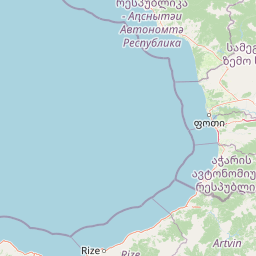
Peaks
მელისციხე
781 m

A detailed atlas exploration of the park area, natural landforms, and regional geography
Examine the physical structure of Mtirala National Park located within the Adjara region of Georgia. This profile provides comprehensive data regarding its 281.26 square kilometer expanse, mapped boundary geometry, and recorded natural features including peaks, rivers, and waterfalls. Discover the environmental characteristics, including temperate forest cover and riverine habitats that define the protected landscape.

Georgia's wettest wilderness:Colchic rainforests and a global raptor migration crossroads
Mtirala National Park is a protected area in the Adjara region of western Georgia, spanning approximately 15,698 hectares across the municipalities of Kobuleti, Khelvachauri, and Keda in the western Lesser Caucasus. The park sits between the Black Sea and the Adjara Mountains, adjoining Kintrishi National Park to the north. Established in 2006 and designated as an IUCN Category II protected area, the park was inscribed on the UNESCO World Heritage List in 2021 as part of the Colchic Rainforests and Wetlands. The park's name, Mtirala, meaning "to cry" in Georgian, reflects the extraordinary rainfall that characterizes this landscape—one of the wettest areas in the former Soviet Union. The park protects outstanding Colchic relict forests and diverse wetland ecosystems that represent remarkable biological heritage of the Caucasus region.
National and regional placement within the Adjara territory of Georgia
Mtirala National Park’s outline frames a 281.26 km² area
Mixed terrain classifications and recorded watershed features
Peaks
781 m
Peaks
852 m
Streams
Streams
Peaks
1,193 m
Peaks
918 m
Temperate climate zones, dominant forest cover, and mixed relief features
Mountains · Forest · Woodland · Rivers · Wetland
Temperate broadleaf forest · Riverine habitat · Wetland
Trace the mapped geography of protected areas and national parks surrounding Mtirala National Park
East

Explore the mapped geographic boundaries of this unique Georgian national park.
Kintrishi National Park, located in Georgia's Adjara region, is a protected landscape renowned for its exceptionally intact Colchic deciduous forests within a steep river gorge. This area showcases dense woodland, dramatic terrain, and the unique Colchican willow species, offering rich geographic context. As a key protected area, Kintrishi National Park provides a valuable focus for atlas-based exploration of southwestern Georgia's natural heritage.
Southwest
Explore Georgia's unique Caucasus mountain geography and mapped park boundaries.
Machakhela National Park represents a crucial protected area in Georgia's Adjara region, safeguarding the integrity of ancient Colchic broadleaf forests. This park's landscape is characterized by the steep Machakhelistsqali River valley, carved into the lower Caucasus mountains, offering a distinct geographic profile for atlas exploration. Discover the park's specific terrain, mapped boundaries, and its ecological significance as a vital component of the regional natural heritage.
North
Explore the peat bogs, coastal ecosystems, and bird migration routes.
Discover Kolkheti National Park, a key protected national park located in Georgia's western coastal region. This atlas entry focuses on the park's extensive wetland environments, including its significant peat bogs and Lake Paliastomi, highlighting its role as a critical migratory bird corridor and a unique natural landscape within the Black Sea region. Understand its geographic context and protected area boundaries.
South

Explore protected landscape, waterfalls, and botanical diversity.
Hatila Valley National Park represents a significant protected area within Artvin Province, Turkey, notable for its exceptionally steep, V-shaped river valley. This national park features a striking volcanic landscape characterized by deep gorges, numerous waterfalls, and unique geomorphological structures. Its rich botanical diversity, with 769 documented plant species including many endemics, positions it as a key site for understanding protected landscapes and regional flora. The park's geographic setting at the eastern end of the Kaçkar Mountains provides context for its Mediterranean climate and varied terrain.
Southeast
Discover Artvin Province's unique landslide lake and alpine terrain.
Karagöl-Sahara National Park presents a compelling protected landscape in Artvin Province, Turkey, renowned for its dramatic landslide lake, Karagöl, and the expansive Sahara plateau. This national park provides a unique map of highland geography, featuring dense conifer forests that give way to alpine meadows at elevations around 1,800 meters. Examine the geological character, including active landslide zones and sedimentary formations, that shape this distinctive terrain and contribute to its protected ecological value within the Black Sea Region.

East
Explore its unique forests, wildlife, and mountain terrain.
Delve into Borjomi-Kharagauli National Park, a significant protected area in Georgia's Lesser Caucasus region. This national park is renowned for its extensive old-growth forests, including rare Colchian fragments, and a remarkable concentration of endemic species. The park's dramatic mountainous terrain, spanning over 1,000 square kilometers, offers a rich tapestry of landscapes from deep valleys to alpine meadows, providing critical habitat for large mammals and contributing significantly to the region's biodiversity. Explore its mapped boundaries and geographic context for a deeper understanding of this vital conservation landscape.
Southwest
Discover the dramatic glacial valleys and ridgelines.
Kaçkar Mountains National Park stands as a protected sentinel of Turkey's rugged alpine beauty. This national park encompasses dramatic peaks, glacier-carved valleys, and extensive highland meadows, offering a rich tapestry of mountain geography. Explore the mapped boundaries and landscape context of this iconic protected area, understanding its position within the broader topography of Turkey's Black Sea region.
Southeast
Explore the unique geography and mapped park boundaries of this Georgian protected area.
Delve into Javakheti National Park, a significant protected landscape located in Georgia's Samtskhe, Javakheti region. This page serves as an entry point for understanding the park's distinctive highland terrain, its remarkable chain of lakes and marshes, and its protected area status. Explore the geographic context of this national park, its role in wetland conservation, and its value for structured atlas-based discovery of natural landscapes.
Deepen your understanding of Mtirala National Park by exploring its detailed geographic context and mapped protected boundaries. Discover how its unique terrain, extreme rainfall, and ancient forests contribute to its status as a significant protected area. This atlas perspective helps connect Mtirala National Park to the broader natural geography of Adjara and the Caucasus region for comprehensive discovery.