
Islands
Park geography
Detailed spatial analysis of regional terrain, coastal landscapes, and natural features.
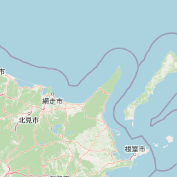
Comprehensive Geographic Profile and Mapped Boundaries of Shiretoko National Park, Hokkaido
Review the precise geographic scope and mapped extent of Shiretoko National Park located in Hokkaido, Japan. This profile covers structural measurements, mountainous terrain, volcanic peaks, coastal boundaries, and various natural water features spanning the recorded area.
Related tags
Brown bear habitatWorld Heritage SiteRemote peninsulaCoastal cliffsTemperate forest
Remote peninsula sanctuary of Japan's largest brown bear population and dramatic coastline
Shiretoko National Park
Shiretoko National Park encompasses the majority of the Shiretoko Peninsula at the far northeastern tip of Hokkaido, Japan, representing one of the most remote and ecologically significant protected areas in the country. The park derives its name from the Ainu phrase 'sir etok,' which translates to 'the place where the earth protrudes,' reflecting the dramatic topography of this finger-like landform extending into the Sea of Okhotsk. Established in 1964, the park protects a landscape of rugged cliffs, pristine forests, volcanic foothills, and rich marine environments that support remarkable biodiversity. In 2005, Shiretoko was inscribed as a UNESCO World Heritage Site, recognizing its outstanding universal value as a natural heritage area. The peninsula remains accessible only by foot or boat, preserving its wilderness character and making it a destination for those seeking unspoiled nature in Japan's northern frontier.
- Location
- Japan
- Park type
- National park
- Established
- 1964
- Area
- 386.4 km²
Location overview
Coastal island geography and regional borders in Hokkaido
Geographic Location and Regional Profile of Shiretoko National Park
Shiretoko National Park lies in Japan, spanning Hokkaido and the Okhotsk and Nemuro subprefectures. Geographic records track its status as a coastal, marine, and island protected area.
- Countries
- Japan
- Regions
- Hokkaido, Nemuro Subprefecture, Okhotsk Subprefecture
- Primary location
- Hokkaido
- Geographic setting
- Coastal · Island · Marine
Boundary and coordinates
Interactive boundary geometry, spatial limits, and derived measurements
Shiretoko National Park Boundary Map and Spatial Extent
Mapped park outlines provide clear spatial context for analyzing protected boundaries across the terrain. Accompanying boundary facts detail total surface area, coordinate limits, and geographic spans.
- Boundary area
- 605.1 km²
- Boundary perimeter
- 150.4 km
- Northernmost point
- 44.3718° N
- Southernmost point
- 43.981° N
- Easternmost point
- 145.4037° E
- Westernmost point
- 144.976° E
- Geographic centre
- 44.1799° N, 145.2083° E
- North–south span
- 43.4 km
- East–west span
- 34.2 km
Terrain and natural features
Mountain relief classifications and recorded hydrographic features
Shiretoko National Park Terrain and Named Natural Features
Shiretoko National Park features a mountain terrain classification with various recorded streams, lakes, and islands located within its boundaries. Linked feature cards supply names, types, and spatial relationships for each mapped natural entity.
Selected named natural features
Streams
モセミネ川
Lakes
Lake Rausu
Streams
音無川
Streams
ルシャ川
Streams
滝川
Environmental setting
Temperate mountain relief, coastal forests, and major marine water features
Shiretoko National Park Environmental Classification and Physical Setting
Recorded habitat types and landscape features serve as complementary lenses for interpreting physical terrain across Shiretoko National Park. Linked categories connect stored environmental traits directly to related protected area records within the broader geographic atlas.
- Relief
- Mountain
- Climate
- Temperate
- Water
- Major water bodies
- Forest cover
- Mostly forested
Landscape features
Mountains · Forest · Woodland · Waterfalls · Coast · Islands
Habitat types
Temperate broadleaf forest · Temperate coniferous forest · Montane forest · Shrubland · Coastal habitat · Marine habitat
Park atlas
Browse a curated atlas of nearby protected areas and compare the diverse geographic landscapes surrounding Japan's remote Shiretoko Peninsula.
Discover Other National Parks and Protected Areas Near Shiretoko National Park, Japan
After exploring Shiretoko National Park, delve into a geographic comparison of other protected areas, tracing the regional spread of diverse conservation landscapes across Hokkaido and beyond. Examine adjacent coastal zones, volcanic terrain, and forest reserves to understand how various protected areas connect within Japan's northern frontier and compare their unique conservation profiles.
National parkHokkaido
About 78 km away#1 closest
Southwest

Akan Mashu National Park: Hokkaido National Park Geography and Protected Landscape
Mapped protected area boundaries and regional landscape context.
Delve into the distinct geographic identity of Akan Mashu National Park, a protected national park located in Hokkaido, Japan. This page provides detailed atlas-level information focusing on its mapped boundaries, regional landscape context, and the broader geographical significance of this protected natural area. Understand the park's terrain and its role within the Hokkaido region's natural geography for informed discovery.
- Area
- 914.13 km²
- Established
- 1934
- IUCN
- V
- Relief
- Mountain
National parkHokkaido
About 110 km away#2 closest
Southwest
Kushiro-Shitsugen National Park: Protected Wetland Ecosystems and Landscape
Explore the mapped terrain of eastern Hokkaido's vital peatlands.
Kushiro-Shitsugen National Park is a national park in eastern Hokkaido, Japan, safeguarding the nation's largest wetland and peatland. The park encompasses the expansive Kushiro Wetlands, characterized by vast reedbeds and a network of meandering rivers, making it a critical habitat for species like the endangered red-crowned crane. This protected area offers a unique landscape for understanding Japan's freshwater ecosystems and their geographic distribution within the region.
- Area
- 268.61 km²
- Established
- 1987
- IUCN
- II
- Visitors
- 460K annual
National parkJapan
151 km away#3 closest
West
Daisetsuzan National Park: Japan's Premier Volcanic Alpine Protected Landscape
Explore Hokkaido's largest national park and its vast mountain terrain.
Daisetsuzan National Park is a monumental protected area, covering extensive mountainous territory in Hokkaido, Japan. This national park is characterized by its dramatic volcanic geography, featuring numerous peaks over 2,000 meters and a rugged backcountry that defines Japan's northern alpine wilderness. Delve into the mapped boundaries and regional context of this significant protected landscape to understand its unique geological identity and ecological importance.
- Area
- 2,267.64 km²
- Established
- 1934
- IUCN
- II
- Visitors
- 6M annual
National parkHokkaido
About 246 km away#4 closest
Southwest
Hidakasanmyaku-Erimo-Tokachi National Park: Japan's Largest Protected Landscape Atlas
Volcanic peaks, coastal cliffs, and Hokkaido's expansive geography.
Hidakasanmyaku-Erimo-Tokachi National Park represents Japan's largest national park, offering a comprehensive exploration of its protected landscape. This vast area in Hokkaido combines the rugged topography of the Hidaka volcanic mountain range with the striking maritime environment of Cape Erimo. Users can explore detailed geographic contexts, understand the park's extensive boundaries, and appreciate its role as a crucial protected natural area at the intersection of alpine and coastal ecosystems.
- Area
- 2,456.68 km²
- Established
- 2024
- IUCN
- II
- Relief
- Mountain
National parkHokkaido
About 319 km away#5 closest
Northwest
Rishiri-Rebun-Sarobetsu National Park: Volcanic Islands and Coastal Wetlands of Northern Hokkaido
Explore its mapped geography and unique subarctic alpine flora.
Rishiri-Rebun-Sarobetsu National Park in Hokkaido, Japan, offers a unique exploration of dramatic volcanic islands and vital coastal wetland ecosystems. This protected area showcases striking geological formations, from the conical peaks of Rishiri and Rebun islands to the vast peat bogs of the Sarobetsu Plain. Its subarctic environment supports a rich tapestry of alpine flora, providing a distinct case study in protected landscape geography and mapping for the region.
- Area
- 241.66 km²
- Established
- 1974
- IUCN
- II
- Visitors
- 730K annual
National parkHokkaido
About 357 km away#6 closest
Southwest
Shikotsu-Tōya National Park: Hokkaido's Premier Volcanic National Park with Caldera Lakes
Explore mapped terrain, geothermal features, and active volcanoes.
Shikotsu-Tōya National Park, located in Hokkaido, Japan, is a prime example of a protected area defined by its intense volcanic geology. The park features prominent caldera lakes, including Lake Shikotsu and Lake Tōya, surrounded by active volcanic cones and dramatic geothermal landscapes. Its distinctive terrain makes it a key destination for understanding regional geography and the mapped protected areas of Japan's northern island, offering a unique glimpse into dynamic geological processes.
- Area
- 994.73 km²
- Established
- 1949
- IUCN
- II
- Relief
- Mountain
National parkJapan
About 507 km away#7 closest
Southwest
Towada-Hachimantai National Park: Mapping Japan's Volcanic and Alpine Protected Landscapes
Explore the geography of this northern Honshu national park.
Towada-Hachimantai National Park offers a unique atlas perspective on Japan's dynamic volcanic geology and alpine ecosystems. This national park protects a vast expanse of rugged terrain, featuring the iconic caldera of Lake Towada and the expansive volcanic plateaus of the Hachimantai region. Understanding its mapped boundaries reveals the distribution of its characteristic landscapes, from old-growth beech forests along river valleys to subalpine environments crowning volcanic peaks, providing a deep dive into its protected natural geography.
- Area
- 855.34 km²
- Established
- 1936
- IUCN
- II
- Visitors
- 5.9M annual
National parkTōhoku
About 547 km away#8 closest
Southwest
Sanriku Fukkō National Park: National Park Protected Landscape and Regional Geography
Explore mapped boundaries and natural terrain in Tōhoku.
Sanriku Fukkō National Park serves as a pivotal protected area within the Tōhoku region, offering rich geographic detail for atlas exploration. This national park's identity is intrinsically linked to its mapped landscape and protected boundaries, providing valuable insights into northeastern Japan's natural terrain. Through its representation, users gain a structured understanding of the park's place within the regional geography, facilitating a deeper dive into protected land contexts.
- Area
- 285.37 km²
- Established
- 2013
- IUCN
- II
- Relief
- Lowland
MoriAtlas Explorer
Continue Exploring Shiretoko National Park's Geographic and Landscape Details
Deepen your understanding of Shiretoko National Park's protected area significance and its place within Hokkaido's regional geography. Further exploration provides critical context for its mapped landscape features and its role in the national park atlas. Discover the intricacies of its terrain and its contribution to the surrounding natural environment through detailed geographic data.
Browse next
Global natural geography
Explore related park routes
Explore MoriAtlas Global ParksBrowse All MoriAtlas ParksGlobal Park Map DiscoveryMoriAtlas: Browse All CountriesBrowse All MoriAtlas ContinentsNational Park Environment AtlasGrand Canyon National Park AtlasYellowstone National Park AtlasYosemite National Park Atlas and GeographySerengeti National Park AtlasGalápagos National Park Protected LandscapeBanff National Park Geography and AtlasKruger National Park Atlas EntryUluṟu-Kata Tjuṯa National Park AtlasExplore Uluru-Kata Tjuta National Park GeographyPlitvice Lakes National Park AtlasFiordland National Park Protected LandscapeGreat Smoky Mountains National Park AtlasAfghanistan National Parks and Protected AreasAlbania National Parks and Protected AreasAlgeria National Parks and Protected AreasAmerican Samoa National Parks and Protected AreasAndorra National Parks and Protected AreasAngola National Parks and Protected AreasAntarctica National Parks and Protected AreasAntigua and Barbuda Park List