
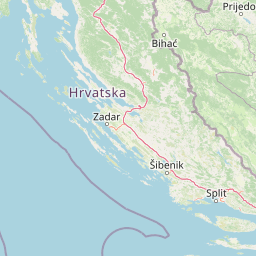
Rivers
Park geography
A detailed atlas of terrain, elevation, and hydrologic features in Bosnia and Herzegovina.
Una National Park Geographic Profile, Boundary Dimensions, and Natural Landscape Features
Una National Park spans 350 square kilometers within Bosnia and Herzegovina, defined by complex riverine and wetland environments. This geographic profile details the park boundary, its recorded maximum elevation of 676 meters, and various named features including Štrbački buk and diverse mountain peaks. The terrain reflects a temperate climate zone characterized by significant water presence, canyons, cliffs, and hills.

Bosnia and Herzegovina's largest national park protecting pristine river canyons and waterfalls
Una National Park
Una National Park is Bosnia and Herzegovina's largest national park, established in 2008 to protect the exceptional natural values of the Upper Una River and its tributaries Krka and Unac. Located in the northwestern corner of the country near the city of Bihać, the park encompasses dramatic river canyons, cascading waterfalls, and karst landscapes that represent some of the most pristine river ecosystems in Europe. The park's protection zone covers approximately 198 square kilometers, with the broader park area extending to about 350 square kilometers. The Una River, rising in Croatia and flowing through the protected area, forms a series of spectacular waterfalls and white-water rapids, with the famous Štrbački Buk waterfall standing as one of the park's most iconic features. Beyond its natural significance, the park contains rich cultural heritage spanning prehistoric, Roman, and medieval periods, including ancient Japodi settlements, medieval fortresses, and the historic Rmanj Monastery.
- Location
- Bosnia and Herzegovina
- Park type
- National park
- Established
- 2008
- Area
- 350 km²
- Highest point
- 676 m
Location overview
National border relationships and transboundary conservation status
Geographic Location of Una National Park in Bosnia and Herzegovina
Una National Park sits positioned within Bosnia and Herzegovina as a protected destination. A recorded transboundary status highlights its cooperative geographic relationship across international frontiers.
- Countries
- Bosnia and Herzegovina
- Primary location
- Bosnia and Herzegovina
- Geographic setting
- Transboundary · Inland
Boundary and coordinates
Interactive protected-area geometry, coordinate limits, and area metrics
Una National Park Boundary Map and Spatial Extent
Mapped park outlines provide immediate spatial context for exploring protected geographic limits and terrain footprints. Accompanying boundary facts detail recorded area measurements, perimeter dimensions, and coordinate spans.
- Boundary area
- 250.6 km²
- Boundary perimeter
- 149.7 km
- Northernmost point
- 44.7492° N
- Southernmost point
- 44.3567° N
- Easternmost point
- 16.3327° E
- Westernmost point
- 15.9234° E
- Geographic centre
- 44.5366° N, 16.1236° E
- North–south span
- 43.6 km
- East–west span
- 32.5 km
Elevation and terrain
Mixed relief profiles and recorded natural landmarks within the protected area
Una National Park Elevation Summary and Terrain Geography
Recorded elevation data establishes the highest point at 676 meters across mixed terrain classifications. Detailed feature cards document individual rivers, peaks, and springs located within the protected area boundaries.
- Maximum elevation
- 676 m
- Highest point
- 676 m
Selected named natural features
Natural springs
Male vode
Streams
Ostrovica
Peaks
Veliki Ljutoč
941 m
Streams
Pomarna
Peaks
Culumak
408 m
Environmental setting
Temperate climate zones, mixed relief, and major water systems
Una National Park Environmental Classifications and Physical Setting
Recorded landscape features, riverine habitats, and water presence combine to form a temperate physical setting. Stored classifications connect directly to broader protected area categories across the atlas.
- Relief
- Mixed relief
- Climate
- Temperate
- Water
- Major water bodies
Landscape features
Rivers · Waterfalls · Canyon · Wetland · Cliffs · Hills
Habitat types
Riverine habitat · Wetland
Park atlas
Trace the Dinaric region's protected landscapes and river canyons, comparing Una National Park with adjacent protected areas.
Discover Other National Parks and Protected Areas Near Una National Park
Browse national parks and protected areas near Una National Park, mapping the extended geographic context of river canyons, waterfalls, and karst landscapes across the Dinaric Mountains region. Compare additional protected areas by their unique conservation priorities and shared regional terrain, furthering your atlas-based exploration beyond Una National Park.
National parkCroatia
About 29 km away#1 closest
Northwest

Plitvice Lakes National Park: Croatia's Iconic National Park and UNESCO Heritage Site
Mapped protected area with cascading lakes and karst geography.
Delve into the protected landscape of Plitvice Lakes National Park, a jewel of Croatia's natural heritage. This atlas entry highlights the park's famous system of 16 terraced lakes and cascading waterfalls, set within a unique karst terrain. Understand the geographic context and mapped boundaries of this significant protected area, renowned for its geological processes and ancient forest ecosystems. Explore the full spectrum of its protected natural identity.
- IUCN
- II
National parkŠibenik-Knin County
34 km away#2 closest
South
Krka National Park: Croatia's National Park with European Cascade Waterfalls
Explore the mapped protected landscape and karst geography.
Krka National Park, designated as a national park in Croatia, offers a rich exploration of its protected landscape. Located in Šibenik-Knin County, the park is defined by the Krka River and its extraordinary seven travertine waterfalls, most notably Skradinski buk, the largest cascade system of its kind in Europe. This atlas-focused view highlights the park's unique karst terrain, Mediterranean ecosystems, and its position within the regional geography, providing essential context for understanding its protected natural heritage.
- Area
- 109 km²
- Established
- 1985
- IUCN
- II
- Relief
- Lowland
National parkCroatia
44 km away#3 closest
West
Paklenica National Park: Croatia's Iconic Karst Canyon and UNESCO Beech Forests
Explore dramatic protected landscape and regional geography.
Paklenica National Park presents a spectacular protected area defined by its deep karst canyons, with Velika Paklenica and Mala Paklenica carving dramatic vertical walls into the Velebit mountain range. This national park is celebrated for its status as a leading European climbing destination and its ancient beech forests, part of a UNESCO World Heritage site. Exploring Paklenica offers insight into unique geological formations, extensive cave systems, and the rich biodiversity of this significant Croatian landscape.
- Area
- 95 km²
- IUCN
- II
- Relief
- Mountain
- Climate
- Mediterranean
National parkBosnia and Herzegovina
71 km away#4 closest
Northeast

Kozara National Park: Bosnia and Herzegovina's Distinctive Forested Mountain Landscape
Mapped protected area in the Pannonian Plain's highland oasis.
Kozara National Park represents a significant protected natural area within Bosnia and Herzegovina, distinguished by its rounded, forested peaks that ascend from the surrounding Pannonian lowlands. This national park offers a unique landscape characterized by dense deciduous and mixed forests, interspersed with clearings and meadows, covering a considerable portion of its 39 square kilometer area. The park's geographic identity is further defined by its proximity to major rivers like the Una, Sava, Sana, and Vrbas, which delineate its natural boundaries and contribute to its distinct regional context. For atlas-based discovery, Kozara provides insight into how isolated highlands create unique protected landscapes within flatter terrain.
- Area
- 39.08 km²
- Established
- 1967
- IUCN
- II
- Relief
- Upland

National parkCroatia
About 73 km away#5 closest
West
Northern Velebit National Park: Croatia's Mapped Protected Landscape Identity
Explore the geography and protected area context.
Northern Velebit National Park stands as a prominent protected area, contributing significantly to the geographic understanding of Croatia's Velebit mountain range. This page provides focused details on its protected landscape features, mapped boundaries, and position within the Dinaric Alps. It serves as an essential entry point for users seeking structured atlas-based information on national parks and their role in regional conservation efforts, highlighting its unique geographic characteristics.
- IUCN
- II
Protected landscapeSisak-Moslavina County
86 km away#6 closest
North
Lonjsko Polje Protected Landscape: Explore Croatia's Largest Inland Wetland and Pastoral Heritage
Discover mapped natural landscapes and unique floodplain geography.
Lonjsko Polje, a significant protected landscape in Croatia's Sisak-Moslavina County, represents the largest inland wetland within the Danube basin. This area is characterized by its vast alluvial floodplain, shaped by seasonal river dynamics, which fosters diverse habitats for wildlife and preserves a rare example of traditional pastoral culture. Explore the mapped geography and understand the ecological importance of this unique wetland ecosystem through structured atlas-style content.
- Area
- 505.6 km²
- Established
- 1998
- IUCN
- V
- Relief
- Lowland
National parkŠibenik-Knin County
90 km away#7 closest
Southwest
Kornati Islands National Park: Dense Mediterranean Archipelago and Protected Karst Landscape
Explore the mapped geography and unique protected island terrain.
Kornati Islands National Park, located in Šibenik-Knin County, Croatia, is distinguished as the Mediterranean's most densely packed archipelago. This national park protects a vast expanse of karst limestone islands, dramatic sea cliffs, and unique flat rock plateaus, alongside its significant marine environment. MoriAtlas provides detailed geographic context and mapped boundaries, enabling structured exploration of this exceptional protected landscape and its ecological significance within the Adriatic Sea.
- Area
- 320 km²
- Established
- 1980
- IUCN
- II
- Relief
- Lowland
Nature reserveDugi Otok
92 km away#8 closest
Southwest
Telašćica Nature Park: Adriatic Sea Cliffs, Lake Mir, and Protected Landscape
Dugi Otok's Premier Nature Reserve on the Dalmatian Coast
Telašćica Nature Park safeguards a highly distinctive coastal environment on Croatia's Dugi Otok island. This protected area is defined by its imposing 161-meter-high vertical limestone cliffs, locally named 'stene,' which create a breathtaking interface with the Adriatic Sea. Within the park, the unique saltwater Lake Mir offers a fascinating geological feature, while the sheltered bay and its surrounding landscape showcase a rich Mediterranean flora and a complex archipelago. The park serves as a prime example of Adriatic karst landscape preservation and mapped coastal geography.
- Area
- 70.5 km²
- Established
- 1988
- IUCN
- II
- Relief
- Mixed relief
MoriAtlas Explorer
Continue Exploring Una National Park's Geographic Identity and Mapped Landscape
Delve deeper into the structured geographic data and mapped landscape context of Una National Park. Understand its role as a protected area, explore its river systems, waterfalls, and karst formations, and see how it fits within the broader regional geography. MoriAtlas helps you navigate and discover the intricate details of this exceptional natural setting, providing a clear atlas-style overview of its terrain and protected boundaries for informed discovery.
Browse next
Global natural geography
Explore related park routes
Explore MoriAtlas Global ParksBrowse All MoriAtlas ParksGlobal Park Map DiscoveryMoriAtlas: Browse All CountriesBrowse All MoriAtlas ContinentsNational Park Environment AtlasGrand Canyon National Park AtlasYellowstone National Park AtlasYosemite National Park Atlas and GeographySerengeti National Park AtlasGalápagos National Park Protected LandscapeBanff National Park Geography and AtlasKruger National Park Atlas EntryUluṟu-Kata Tjuṯa National Park AtlasExplore Uluru-Kata Tjuta National Park GeographyPlitvice Lakes National Park AtlasFiordland National Park Protected LandscapeGreat Smoky Mountains National Park AtlasAfghanistan National Parks and Protected AreasAlbania National Parks and Protected AreasAlgeria National Parks and Protected AreasAmerican Samoa National Parks and Protected AreasAndorra National Parks and Protected AreasAngola National Parks and Protected AreasAntarctica National Parks and Protected AreasAntigua and Barbuda Park List