
Streams
Park geography
Explore recorded terrain characteristics, area measurements, and regional landscape features
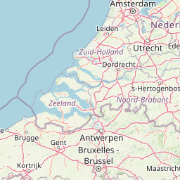
Detailed Geographic Profile and Mapped Boundaries of Van Gogh National Park in North Brabant
Analyze the formal geographic scope of Van Gogh National Park located within the North Brabant region of the Netherlands. This profile provides structured data on its 1200 square kilometer boundary, lowland terrain, and associated natural features including established viewpoints and peaks. Examine the spatial dimensions and environmental classifications defining this protected landscape.
A cultural-natural park honoring Vincent van Gogh's North Brabant homeland
Van Gogh National Park
Van Gogh National Park is a newly established Dutch national park in the province of North Brabant, officially designated in October 2024. The park covers an extensive area of approximately 1,200 square kilometers, making it one of the larger protected landscapes in the Netherlands. It is uniquely positioned as a "national park of the new style," representing a collaborative model that brings together governments, businesses, organizations, and local residents in the planning, promotion, and management of the region. The park is named after Vincent van Gogh (1853–1890), the celebrated post-impressionist painter who was born and worked in various locations throughout North Brabant, making this designation a deliberate celebration of the region's dual cultural and natural heritage.
- Location
- Netherlands
- Park type
- National park
- Established
- 2024
- Area
- 1,200 km²
Location overview
National and regional administrative boundaries in the Netherlands
Geographic Location and Regional Context of Van Gogh National Park
Van Gogh National Park is situated entirely within the North Brabant region of the Netherlands. The inland protected area operates under a single national jurisdiction with no coastal or marine boundaries.
- Countries
- Netherlands
- Regions
- North Brabant
- Primary location
- North Brabant
- Geographic setting
- Inland
Boundary and coordinates
Broad park outline with geographic dimensions
Van Gogh National Park mapped boundary and 1,200 km² area
Van Gogh National Park has mapped geometry framing its recorded 1,200 km² area. The outline offers context with centre, coordinate limits, spans, and perimeter wherever measured, but it does not establish legal-survey boundaries.
- Boundary area
- 492.9 km²
- Boundary perimeter
- 483.5 km
- Northernmost point
- 51.6939° N
- Southernmost point
- 51.4085° N
- Easternmost point
- 5.6232° E
- Westernmost point
- 5.004° E
- Geographic centre
- 51.5772° N, 5.3054° E
- North–south span
- 31.8 km
- East–west span
- 42.9 km
Terrain and natural features
Stored Lowland Classification and Recorded Internal Landscape Entities
Van Gogh National Park Terrain Geography and Named Natural Features
Van Gogh National Park features recorded lowland terrain classifications along with internal natural features such as streams, ponds, and stone markers. Linked feature cards supply names, types, measurements, and verified spatial relationships for each entry.
Selected named natural features
Streams
Endekeloop
Named stones
Everzwijn (24.Keienspoor)
Peaks
Dak van Brabant
60 m
Ponds
Lange Jan
Streams
Verbindingsloopje
Environmental setting
Temperate lowland terrain, partial forest cover, and diverse habitat types
Van Gogh National Park Environmental Setting and Landscape Classifications
Stored classifications combine lowland relief, temperate climate zones, and mixed habitats into complementary perspectives on physical geography. Linked categories connect recorded environmental properties to related atlas destinations where available.
- Relief
- Lowland
- Climate
- Temperate
- Water
- Minor water
- Forest cover
- Partial forest
- Seasonality
- Year-round
Landscape features
Dunes · Woodland · Grassland · Valleys
Habitat types
Temperate broadleaf forest · Heath · Grassland
Park atlas
Trace the regional geography of other protected landscapes and compare park features within North Brabant.
Explore Nearby National Parks and Protected Areas Surrounding Van Gogh National Park
Continue your exploration from Van Gogh National Park by browsing other national parks and diverse protected areas across the surrounding North Brabant region. Comparing these nearby conservation landscapes reveals unique regional terrain, different management models, and the interconnectedness of Dutch protected geography.
National parkNetherlands
Park boundaries overlap#1 closest
West

De Loonse en Drunense Duinen National Park: Explore Dutch Protected Sand Drift Landscapes and Heathlands
National Park with unique living sand drift and dune terrain.
Navigate the geographic contours and protected land boundaries of De Loonse en Drunense Duinen National Park, a premier Dutch natural area. This national park is celebrated for its extensive living sand drift, one of the largest in Northern Europe, alongside significant heathlands and coniferous forests. Gain a structured understanding of its landscape character and its role within regional geography through detailed map context and atlas exploration tools.
- Area
- 35 km²
- Established
- 2002
- IUCN
- II
- Relief
- Lowland
Nature reserveGelderland
9.2 km away#2 closest
North
Loevestein, Pompveld & Kornsche Boezem: Regional Geography and Protected Area Mapping
A composite Natura 2000 network in the central Dutch river delta.
Spanning the Bommelerwaard and Land van Heusden en Altena, Loevestein, Pompveld & Kornsche Boezem represents a vital approach to protecting fragmented lowland habitats. This record provides geographic insight into the diverse riverine mosaic of floodplains, wet grasslands, and historical stream channels that define this protected landscape in the heart of the Netherlands.
- Area
- 7.5 km²
- Established
- 2013
National parkNetherlands
13 km away#3 closest
West
De Biesbosch National Park: A Dutch National Park Mapping Tidal Wetlands and Flood Forests
Explore mapped waterways and diverse protected landscapes.
Delve into the geography of De Biesbosch National Park, a remarkable protected area in the Netherlands renowned for its extensive freshwater tidal wetlands. This national park showcases a unique landscape defined by intricate river systems, dominant willow flood forests, and vital reed beds, serving as a critical habitat for migratory birds and a prime example of wetland restoration. Understand its place within the regional geography through our atlas-driven approach to protected land discovery.
- Area
- 90 km²
- Established
- 1994
- IUCN
- II
- Relief
- Lowland
National parkNetherlands
14 km away#4 closest
Southeast
De Groote Peel National Park: Mapped Boundaries of a Unique Raised Bog & Wetland
Protected area with exceptional birdlife and peat landscape.
De Groote Peel National Park represents a crucial protected landscape in the Netherlands, renowned as one of the last substantial raised bogs in Western Europe. Its terrain is characterized by a distinct blend of open lakes formed by historical peat extraction, heathland expanses, and sensitive peat swamps. This Ramsar-designated wetland is a vital habitat for numerous bird species, offering unique opportunities for landscape context and atlas exploration of its ecological significance and mapped geographic features.
- Area
- 13.4 km²
- Established
- 1993
- IUCN
- II
- Relief
- Lowland
Nature reserveGelderland
About 21 km away#5 closest
North
Lingegebied & Diefdijk-Zuid: Protected Nature Reserve in Central Netherlands
A fragmented river landscape spanning three provinces
Lingegebied & Diefdijk-Zuid is a designated Natura 2000 nature reserve characterized by its scattered parcels of protected land. The area is deeply integrated into the Dutch river landscape, following the path of the Linge river and the historic Diefdijk. Its unique geography across four municipalities showcases the complex relationship between regional water management and protected European habitat types.
- Area
- 7.5 km²
- Established
- 2013
- Relief
- Lowland
- Climate
- Temperate
National parkLimburg
33 km away#6 closest
East
De Maasduinen National Park: Mapping the Longest River Dune System in the Netherlands
Protected Landscape and Dune Terrain in Limburg
Delve into the geographic identity of De Maasduinen National Park, a vital protected area in Limburg. This page offers detailed insights into its remarkable dune landscape, heathlands, and forests, emphasizing its role within the Dutch natural atlas and its connections to surrounding conservation areas.
- Area
- 45 km²
- Established
- 1996
- IUCN
- II
- Relief
- Lowland
National parkLimburg
33 km away#7 closest
Southeast

Hoge Kempen National Park: National Park Protected Landscape and Limburg Geographic Context
Explore mapped boundaries within the Limburg region.
Gain a comprehensive understanding of Hoge Kempen National Park as a distinct protected national park. This resource provides critical insights into its geographic setting within the Limburg region, detailing its mapped boundaries and overall landscape context. It serves as an essential point for atlas exploration, allowing users to appreciate the park's role as a protected natural area and its place within the regional geography of Belgium.
- Area
- 127 km²
- Established
- 2006
- IUCN
- II
- Visitors
- 1M annual
Protected areaNetherlands
About 34 km away#8 closest
Northeast
Kolland en Overlangbroek: Mapping the Rare Ash Floodplain Forest of the Netherlands
Historic estate landscape and protected woodland habitat.
Located between Wijk bij Duurstede and the Utrechtse Heuvelrug, Kolland en Overlangbroek preserves a vital fragment of alluvial ash forest. This protected area offers deep insight into Dutch floodplain geography, featuring a distinct mosaic of sandy ridges, silty backswamps, and centuries-old woodland managed for its unique bryophyte flora and groundwater-fed ecosystem.
- Area
- 1.1 km²
- Relief
- Lowland
- Climate
- Temperate
- Scope
- Terrestrial
MoriAtlas Explorer
Continue Exploring Van Gogh National Park's Geographic Identity and Mapped Landscapes
Deepen your understanding of Van Gogh National Park by exploring its specific protected area boundaries, diverse terrains, and regional geography within North Brabant. MoriAtlas provides structured data to navigate its unique blend of natural features and cultural significance, offering unparalleled atlas-based discovery of this dynamic Dutch landscape.
Browse next
Global natural geography
Explore related park routes
Explore MoriAtlas Global ParksBrowse All MoriAtlas ParksGlobal Park Map DiscoveryMoriAtlas: Browse All CountriesBrowse All MoriAtlas ContinentsNational Park Environment AtlasGrand Canyon National Park AtlasYellowstone National Park AtlasYosemite National Park Atlas and GeographySerengeti National Park AtlasGalápagos National Park Protected LandscapeBanff National Park Geography and AtlasKruger National Park Atlas EntryUluṟu-Kata Tjuṯa National Park AtlasExplore Uluru-Kata Tjuta National Park GeographyPlitvice Lakes National Park AtlasFiordland National Park Protected LandscapeGreat Smoky Mountains National Park AtlasAfghanistan National Parks and Protected AreasAlbania National Parks and Protected AreasAlgeria National Parks and Protected AreasAmerican Samoa National Parks and Protected AreasAndorra National Parks and Protected AreasAngola National Parks and Protected AreasAntarctica National Parks and Protected AreasAntigua and Barbuda Park List