Mori Atlas logo
National parkAigüestortes i Estany de Sant Maurici National Park

Discover the glacial lakes, winding streams, and alpine terrain of this Catalan National Park.

Aigüestortes i Estany de Sant Maurici National Park: Protected Landscape Geography in the Pyrenees

(Parc Nacional d'Aigüestortes i Estany de Sant Maurici)

Aigüestortes i Estany de Sant Maurici National Park represents a prime example of high-mountain protected landscape within Catalonia's Province of Lleida. This national park is renowned for its stunning concentration of nearly 200 glacial lakes and the iconic Sant Maurici lake set against the dramatic peaks of Els Encantats. The unique 'winding waters' of the Aigüestortes plain offer a fascinating hydrological study within an alpine environment. Explore the mapped boundaries and intricate terrain of this significant Pyrenean conservation area through our structured atlas.

National ParkPyreneesGlacial LakesHigh MountainsCataloniaAlpine Environment

Aigüestortes i Estany de Sant Maurici National Park

National park

Park overview

Structured park overview, official facts, and landscape profile for Aigüestortes i Estany de Sant Maurici National Park

Aigüestortes i Estany de Sant Maurici National Park park facts, protected area profile, and essential visitor context
Review the core facts for Aigüestortes i Estany de Sant Maurici National Park, including designation, size, terrain, visitor scale, habitats, and operating context in one park-focused overview.

About Aigüestortes i Estany de Sant Maurici National Park

Aigüestortes i Estany de Sant Maurici National Park occupies a pristine corner of the central Pyrenees where ancient geological processes and quaternary glaciations have shaped an extraordinary landscape. The park straddles the comarques of Pallars Sobirà, Alta Ribagorça, Pallars Jussà, and Val d'Aran, with the core protected area centred on two main valleys: the Boí valley to the west containing the Aigüestortes plain, and the Espot valley to the east where Sant Maurici lake lies at the foot of Els Encantats. The geological foundation consists of very old Paleozoic granite and slate rocks that were uplifted during the Alpine orogeny, then dramatically modified by successive glaciations that carved the U-shaped valleys, sharp peaks, vertiginous ridges, and the countless lakes that define the park's character today. The climate is predominantly cold, with mean temperatures between zero and five degrees Celsius and annual precipitation ranging from 900 to 1,300 millimetres, falling mainly as snow in the higher elevations. This combination of harsh climate, dramatic topography, and relative inaccessibility has allowed the park to maintain a remarkably wild character despite centuries of human activity in the surrounding valleys.

Quick facts and research context for Aigüestortes i Estany de Sant Maurici National Park

Located in the Province of Lleida in Catalonia, Aigüestortes i Estany de Sant Maurici is the fifth oldest and the only national park in Catalonia. The park features an elevation range from 1,600 to 3,000 metres, with Besiberri Sud reaching 3,017 metres as the highest peak. Nearly 200 glacial lakes punctuate the landscape, making this the most lacustrine area in the Pyrenees. The park is administered jointly by the Spanish Ministry of Environment and the Catalan Department of Agriculture, Livestock, Fisheries, Food, and the Environment, with administrative offices in Espot and Boí. Since 2007, the park has held Ramsar Convention designation as a protected wetland. The GR-11 trans-Pyrenees hiking trail crosses the park, providing access to some of the most spectacular high-mountain terrain in the region.

Park context

Deeper park guide and search-rich context for Aigüestortes i Estany de Sant Maurici National Park

Aigüestortes i Estany de Sant Maurici National Park history, landscape, wildlife, and travel context
Explore Aigüestortes i Estany de Sant Maurici National Park through its history, landscape character, ecosystems, wildlife, conservation priorities, cultural context, and seasonal travel timing in a structured park guide built for atlas discovery and search intent.

Why Aigüestortes i Estany de Sant Maurici National Park stands out

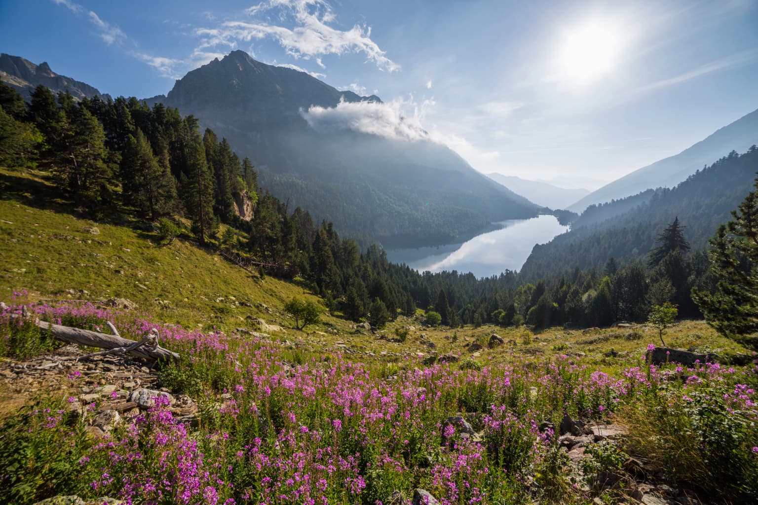
Aigüestortes i Estany de Sant Maurici is best known for its exceptional concentration of glacial lakes and the striking landscape of Sant Maurici lake framed by the dramatic twin peaks of Els Encantats, which appears on the park's official logo. The Aigüestortes plain, meaning "winding waters," gives the park its name and showcases the distinctive meandering streams that flow slowly across a flat valley floor, a rare hydrological feature in mountain terrain. The park protects one of the most important high-mountain ecosystems in the Pyrenees, with four distinct vegetation zones supporting remarkable biodiversity. Visitors are drawn to the network of mountain refuges that enable multi-day treks through this pristine alpine environment, as well as the opportunity to observe species such as the Pyrenean chamois, golden eagle, and bearded vulture in their natural habitat.

Aigüestortes i Estany de Sant Maurici National Park history and protected-area timeline

Human presence in the high Pyrenees dates back at least 8,500 years to the Neolithic period, though archaeological evidence indicates only temporary settlements within the current park boundaries rather than permanent habitation. The 19th century brought intense exploitation of forest resources, farming, and fishing as the high Pyrenees became more densely populated. The early 20th century saw the construction of hydroelectric power plants that transformed the landscape through dam construction and water diversions. On 21 October 1955, the park was officially created as Spain's fifth national park, originally covering 9,851 hectares under the name "Parque Nacional de Aiguas Tortas y Lago de San Mauricio." The Catalan government assumed management responsibilities in 1988 according to Catalan law, establishing the buffer zone and implementing stricter protection measures. A significant enlargement occurred in 1996, expanding the core area to its current extent. Following legal disputes between Catalan and Spanish authorities, a 1997 agreement restored the park's status within Spain's national park system while allowing autonomous community participation in management.

Aigüestortes i Estany de Sant Maurici National Park landscape and geographic character

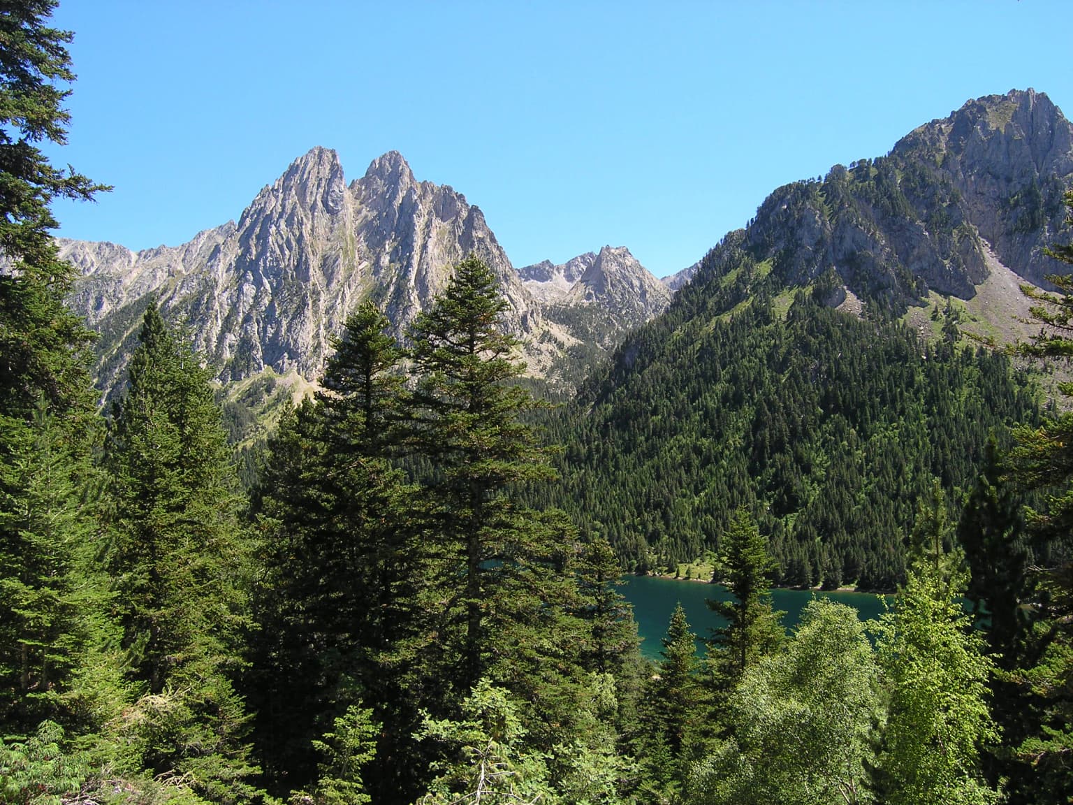
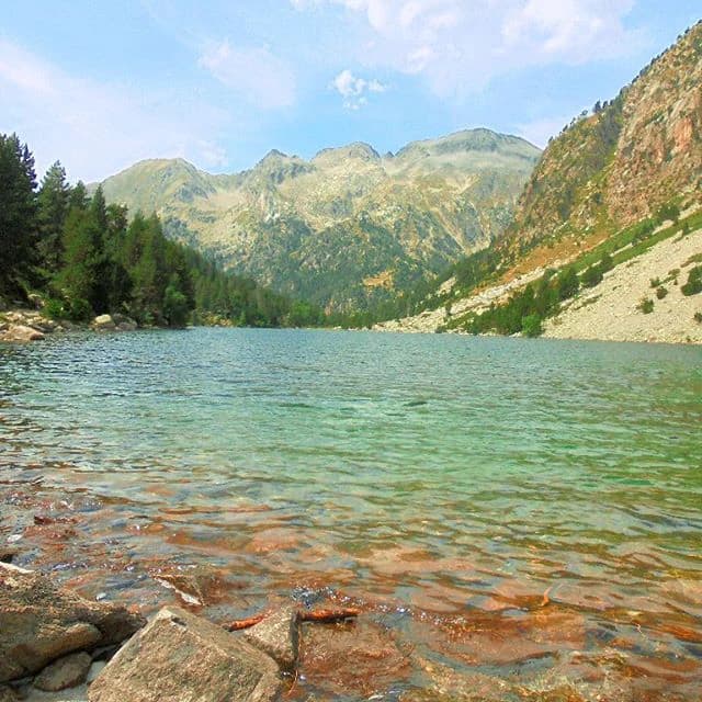
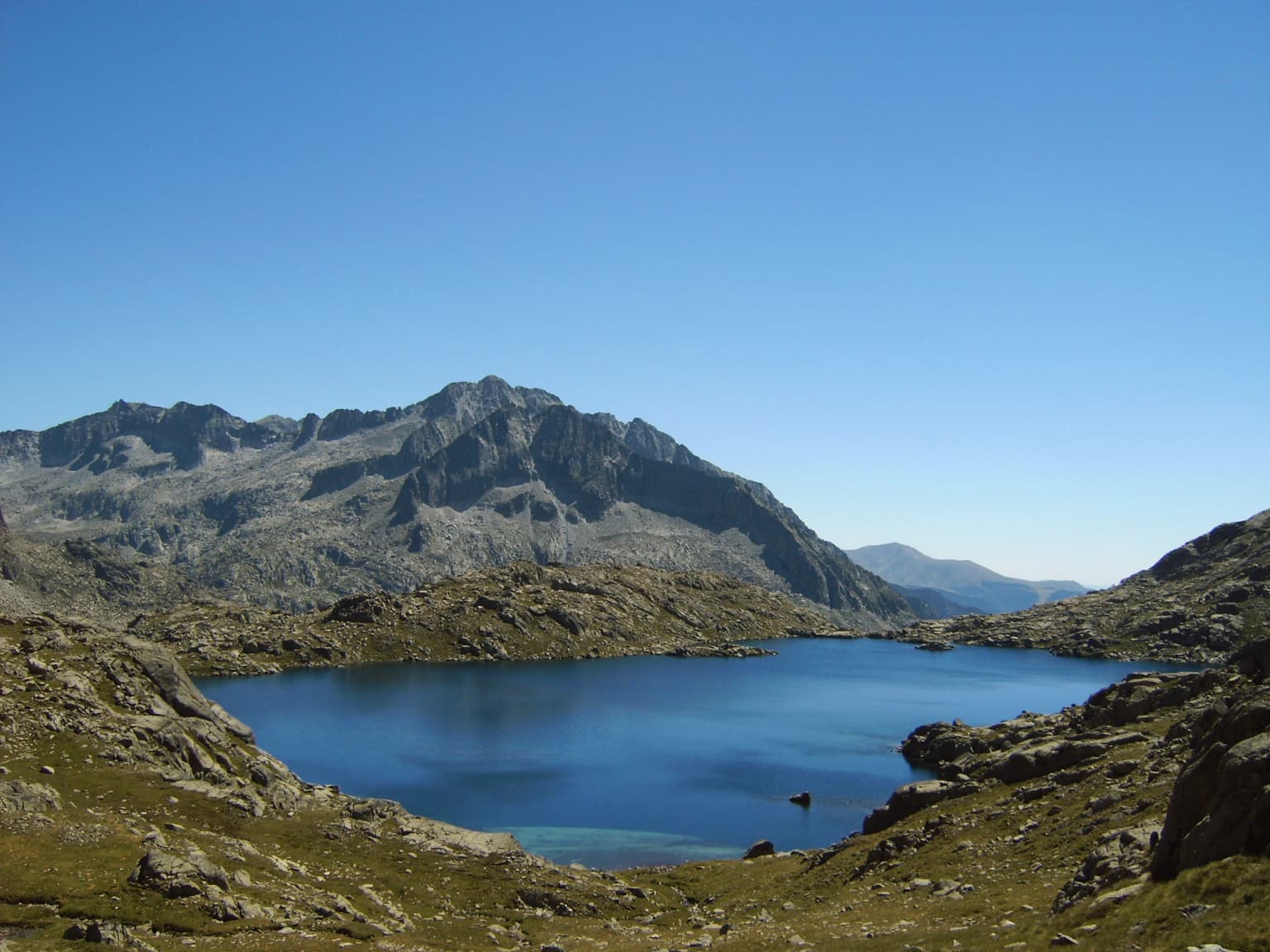
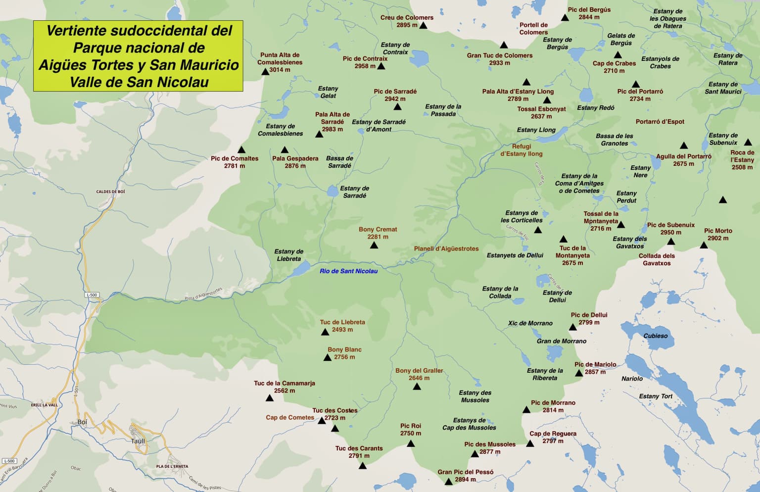
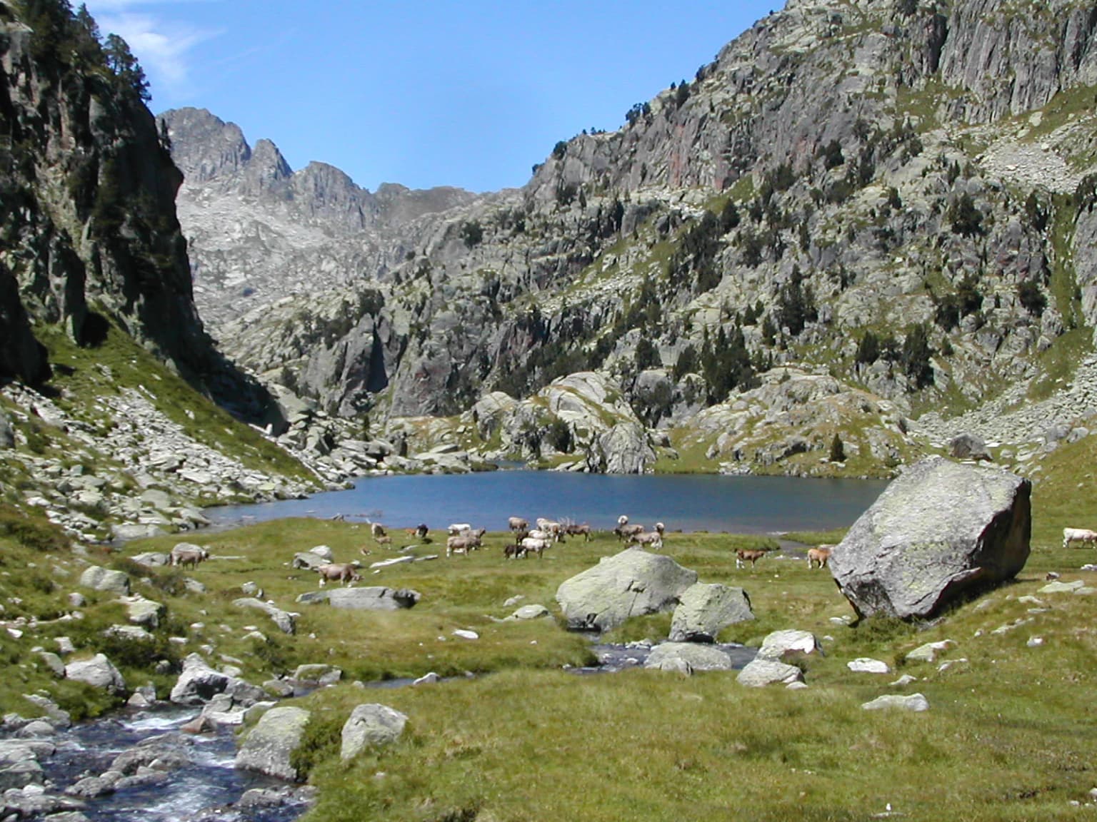
The landscape of Aigüestortes i Estany de Sant Maurici presents an archetypal high-mountain environment shaped by ancient glacial processes. The most striking features are the nearly 200 lakes, most of glacial origin, which together form the most important lacustrine complex in the Pyrenees. The western sector centres on the Aigüestortes plain, a remarkably flat area where the Sant Nicolau river meanders slowly across sediments deposited in what was once a larger lake, creating the winding channels that give the park its name. The eastern sector features Sant Maurici lake, a classic glacial tarn set beneath the twin peaks of Els Encantats, one of the most photographed scenes in the Pyrenees and the symbol of the park. The surrounding terrain includes cirques such as Colomers and Saboredo, the Besiberri valley with its dramatic peaks reaching over 3,000 metres, and the Montardo massif. U-shaped valleys, sharp ridges, and hanging valleys are characteristic of this landscape, while waterfalls fed by glacial meltwater descend from hanging valleys into the main drainage systems.

Aigüestortes i Estany de Sant Maurici National Park ecosystems, habitats, and plant life

The ecological diversity of Aigüestortes i Estany de Sant Maurici stems from its significant elevation range and the varied orientation of its valleys, creating distinct microclimates and habitat conditions. Four major vegetation zones traverse the park: lower montane forests of deciduous species including pubescent oak, European ash, beech, and common hazel; upper montane forests dominated by mountain pine growing up to 2,400 metres; subalpine zones with rhododendron and blueberry understory; and alpine meadows above the tree line where only hardy herbs can survive. Approximately eight percent of the park's plant species are endemic to the Pyrenees, while around seven percent have boreo-alpine or arctico-alpine distributions representing species that arrived during the last Ice Age. La Mata de Valencia contains the largest silver fir forest in the Pyrenees. The park serves as an important watershed, with rivers feeding the Noguera Pallaresa, Noguera Ribagorzana, and Garona basins through a complex hydrological network.

Aigüestortes i Estany de Sant Maurici National Park wildlife and species highlights

The wildlife of Aigüestortes i Estany de Sant Maurici, while challenging to observe due to the terrain and the skittish nature of many species, includes approximately 200 vertebrate species with roughly two-thirds being birds. The Pyrenean chamois represents one of the most characteristic mammals, often spotted on rocky slopes, while the brown bear, though rarely seen, maintains a presence in the park. Other mammals include the stoat, introduced alpine marmot, roe deer, and fallow deer. The avifauna is particularly rich, featuring the western capercaillie in coniferous forests, rock ptarmigan on high rocky terrain, golden eagle and griffon vulture soaring over the peaks, and the bearded vulture, also known as lammergeier, a species for which the Pyrenees are a significant stronghold. The black woodpecker inhabits old-growth forests, while the wallcreeper graces cliff faces with its distinctive crimson wings. The Pyrenean brook salamander is a significant amphibian endemic to the northern Iberian Peninsula, though difficult to find among the park's streams and lakes.

Aigüestortes i Estany de Sant Maurici National Park conservation status and protection priorities

Aigüestortes i Estany de Sant Maurici holds significant conservation value as Catalonia's only national park and as a Ramsar-designated wetland since 2007. The park's protection extends across a core area of 14,119 hectares with a surrounding buffer zone of 26,733 hectares, creating a graduated protection scheme. The diverse ecosystems, from deciduous forests through subalpine conifers to alpine meadows, support significant biodiversity including endemic Pyrenean species and relict boreo-alpine flora that survived the last glaciation. Conservation measures prohibit resource exploitation within the core area, though traditional livestock grazing and hydroelectric generation continue under managed concessions. The park also functions as a Special Protection Area for Birds and a Special Area of Conservation under the European Union's Natura 2000 network, providing formal protection for species such as the capercaillie and bearded vulture that require specific habitat conditions.

Aigüestortes i Estany de Sant Maurici National Park cultural meaning and human context

The cultural landscape surrounding Aigüestortes i Estany de Sant Maurici reflects centuries of traditional mountain life in the Pyrenean valleys. While the park itself contains no permanent settlements, the surrounding comarques maintain pastoral traditions that have shaped the landscape over millennia. The Vall de Boí, just outside the park boundaries, contains a remarkable ensemble of Romanesque churches that UNESCO designated as a World Heritage Site in 2000, demonstrating the deep historical connection between human communities and this mountain environment. The mountain refuges scattered throughout the park represent a continuation of traditional high-mountain shelter practices, now adapted for modern trekking use. The park's information centres at Boí and Espot, along with the Museum of the Shepherds at Llessui, provide context about the historical relationship between Pyrenean communities and their mountain environment.

Top sights and standout views in Aigüestortes i Estany de Sant Maurici National Park

The park's standout features include the iconic Sant Maurici lake with its backdrop of Els Encantats peaks, the vast network of nearly 200 glacial lakes scattered throughout cirques and valleys, and the remarkable Aigüestortes plain where slow-moving waters create an almost wetland-like environment in the high mountains. The diversity of vegetation zones from deciduous forests through mountain pine to alpine meadows provides visual variety and supports ecological complexity. The network of ten guarded mountain refuges enables multi-day treks through the most spectacular terrain, including the challenging Carros de Foc circuit that circles between refuges. The GR-11 trans-Pyrenees trail provides access for serious hikers, while shorter walks from both Boí and Espot offer accessible introductions to the park's landscapes. Wildlife viewing opportunities, particularly for Pyrenean chamois and birds of prey, add another dimension to the visitor experience.

Best time to visit Aigüestortes i Estany de Sant Maurici National Park

The optimal season for visiting Aigüestortes i Estany de Sant Maurici runs from late June through September, when the high-mountain trails are snow-free and the refuges operate with full services. July and August bring the warmest conditions and the longest days for trekking, though they also coincide with the highest visitor numbers. September often offers excellent conditions with thinner crowds and the added possibility of seeing autumn colour in the lower forests. The park is accessible year-round for day visits from nearby villages, but winter access to the interior is severely limited by snow and the closure of refuges, making it essentially a summer and autumn destination for backcountry exploration. Spring arrives late in these high elevations, with snow typically persisting in passes and north-facing cirques until early summer.

Park location guide

Geography guide, regional context, and park location map for Aigüestortes i Estany de Sant Maurici National Park

Aigüestortes i Estany de Sant Maurici National Park park geography, regions, and map view in Spain
Understand where Aigüestortes i Estany de Sant Maurici National Park sits in Spain through a broader geographic reading of the surrounding landscape, nearby location context, and its mapped position within the national park landscape.

How Aigüestortes i Estany de Sant Maurici National Park fits into Spain

Spain, officially the Kingdom of Spain, is a unitary parliamentary constitutional monarchy located in Southern and Western Europe. The country occupies most of the Iberian Peninsula and includes territories in the Mediterranean and Atlantic. With a population of approximately 49.6 million and an area of 506,030 km², Spain is a major European economy and cultural force. Its capital is Madrid, and the country is known for its diverse landscapes ranging from mountainous regions to coastal areas.

Wider geography shaping Aigüestortes i Estany de Sant Maurici National Park in Spain

Spain occupies the Iberian Peninsula in Southern and Western Europe. Peninsular Spain is bordered to the north by France, Andorra, and the Bay of Biscay; to the east and south by the Mediterranean Sea and Gibraltar; and to the west by Portugal and the Atlantic Ocean. The territory includes the Canary Islands in the Atlantic Ocean, the Balearic Islands in the Mediterranean Sea, and the autonomous cities of Ceuta and Melilla in mainland Africa. Spain features diverse terrain including the Pyrenees in the northeast, the Sierra Nevada in the south, and the Meseta Central plateau.

Map view of Aigüestortes i Estany de Sant Maurici National Park

Use this park location map to pinpoint Aigüestortes i Estany de Sant Maurici National Park in Spain, understand its exact geographic position, and read its mapped placement within the surrounding landscape more clearly.

Pigeon | © OpenStreetMap contributors

Location context for Aigüestortes i Estany de Sant Maurici National Park

CataloniaProvince of Lleida
Park atlas

Compare other national parks and protected areas, tracing their geographic spread across the Pyrenees and Catalonia.

Discover More National Parks and Protected Areas Near Aigüestortes i Estany de Sant Maurici National Park
After exploring Aigüestortes i Estany de Sant Maurici National Park, browse other national parks and protected areas situated within the Province of Lleida and the broader Pyrenean mountain range. This geographic overview helps compare diverse conservation landscapes, from glacial lakes to alpine ecosystems, providing essential context for regional park discovery.
Watercolor painting of a river winding through a valley with green fields, trees, and distant hills
Protected area

Parc Natural Comunal de les Valls del Comapedrosa: Andorra's Highest Protected Alpine Landscape

Explore the Pyrenean terrain and mapped boundaries of Andorra's summit park.

Parc Natural Comunal de les Valls del Comapedrosa is the primary high-altitude protected area in Andorra, defined by its rugged alpine terrain and the presence of Coma Pedrosa, the country's highest peak. This protected landscape offers a significant geographic anchor for exploring the Pyrenees, highlighting the unique mountain conservation efforts. Its mapped boundaries encompass dramatic valleys and steep ridges, providing a clear context for understanding Andorra's mountainous geography through a structured atlas lens.

Area
15.43 km²
Established
2003
IUCN
IV
Relief
Mountain
Watercolor painting showing a mountain range with a winding river through a valley
National park

Ordesa y Monte Perdido National Park: Glacial Terrain and Pyrenean Protected Landscape

Explore its dramatic valleys, cliffs, and alpine geography.

Ordesa y Monte Perdido National Park is a critical protected area within the Pyrenean geography, defined by its spectacular glacial valleys, towering limestone massifs, and unique karst formations. As a National Park and UNESCO World Heritage Site, it offers a rich environment for exploring mapped terrain and understanding the interplay of geology and high-alpine ecosystems. Delve into the mapped boundaries and distinct landscape features that characterize this significant protected landscape.

Area
156.08 km²
Established
1918
IUCN
II
Relief
Mountain
National parkHautes-Pyrénées

Pyrénées National Park: Protected Landscape & Transboundary Protected Area Atlas

Discover Hautes-Pyrénées' dramatic glacial terrain and alpine environments.

Pyrénées National Park is a significant protected area in France's Hautes-Pyrénées department, renowned for its dramatic glacial cirques, high-altitude lakes, and extensive mountain landscapes. Established as a national park, it offers rich geographic context for atlas exploration, showcasing millions of years of geological formation shaped by tectonic uplift and glacial carving. This park is also notable for its transboundary conservation efforts with Spain, contributing to a broader protected region. Explore its unique terrain, from towering limestone formations to alpine meadows, and understand its place within the Pyrenean mountain range.

Area
458 km²
Established
1967
IUCN
II
Relief
Mountain
Watercolor illustration of green fields, a river, and mountains under a soft pink and yellow sky
National parkOccitanie

Cévennes National Park: Explore its Mapped Terrain and Protected Landscape in Occitanie

Discover the unique geographic context and park boundaries.

Cévennes National Park, situated in Occitanie, France, offers a rich exploration of mid-mountain Mediterranean geography. As a protected landscape, its mapped terrain features dramatic limestone plateaus, deep river gorges, and distinct granite massifs. This entry provides essential geographic context for Cévennes National Park, highlighting its unique natural features and its significance as a protected area within the broader regional atlas.

Area
937 km²
Established
1970
IUCN
V
Visitors
800K annual
National parkBouches-du-Rhône

Calanques National Park: Mediterranean Limestone Cliffs and Marine Protected Area

France's First Peri-Urban National Park

Calanques National Park, situated in the Bouches-du-Rhône department, represents a significant protected landscape where dramatic limestone geology meets the Mediterranean Sea. This atlas-focused entry details the park's iconic calanques, its combined terrestrial and marine protected zones, and its rich prehistoric cultural significance. Understand its unique geographic setting and its importance as a conservation area accessible for map-based discovery and regional landscape context.

Area
520 km²
Established
2012
IUCN
II
Relief
Mountain
Watercolor painting of a landscape with trees, hills, and a body of water
National park

Port-Cros National Park: French Mediterranean Island National Park & Marine Sanctuary

Discover mapped protected land and unique Mediterranean ecosystems.

Port-Cros National Park offers a glimpse into a pioneering model of integrated terrestrial and marine conservation within the Mediterranean. This park protects a distinctive island geography marked by rugged terrain, endemic species, and vital underwater habitats, including crucial posidonia meadows and rich marine life. Through MoriAtlas, explore the mapped boundaries and ecological significance of Port-Cros, understanding its role as a vital protected landscape in the European atlas.

Area
46 km²
Established
1963
IUCN
II
Visitors
1M annual
Watercolor illustration depicting a mountain range, river, and green vegetation under a light sky
National park

Sierra de Guadarrama National Park: Protected Area Landscape and Geographic Context

Explore diverse high Mediterranean mountain terrain and ecosystems.

Sierra de Guadarrama National Park is a significant protected national park in central Spain, characterized by its extensive granite landscapes and eleven distinct ecosystems. This park protects crucial high Mediterranean mountain environments, ancient pine forests, and dramatic glacial formations. Its geographic position within the Sistema Central makes it essential for understanding the regional geography and mapped terrain of the Iberian Peninsula, offering a unique look at a vital protected landscape.

Area
339.6 km²
Established
2013
IUCN
II
Visitors
3M annual
National park

Picos de Europa National Park: Dramatic Limestone Peaks and Protected Landscape Atlas

Explore Spain's historic national park and UNESCO Biosphere Reserve.

Picos de Europa National Park offers an unparalleled exploration of dramatic limestone peaks, deep glacial valleys, and extensive Atlantic forests. As Spain's oldest national park and a UNESCO Biosphere Reserve, it presents a remarkable study in karst landscape evolution and biodiversity conservation. This protected area, spanning significant territory across northern Spain, provides a rich geographic context for understanding regional natural heritage and mapped natural features.

Area
671.27 km²
Established
1918
IUCN
II
Relief
Mountain

Common questions about visiting, size, designation, and location context for Aigüestortes i Estany de Sant Maurici National Park

Aigüestortes i Estany de Sant Maurici National Park FAQs for park facts, access, geography, and protected area context
Find quick answers about Aigüestortes i Estany de Sant Maurici National Park, including protected-area facts, park geography, trail and visitor context, and how the park fits into its surrounding country and regional landscape.
MoriAtlas Explorer

Continue Your Protected Areas Search Across the Global Atlas

Deepen your exploration by continuing the structured search for national parks and protected areas worldwide. Utilize the comprehensive filtering capabilities to compare different conservation landscapes and refine your understanding of global park geography. Discover more about the distribution and characteristics of protected natural areas.

Global natural geography