

Mori Atlas logo
Wildlife reserveAstore Wildlife Sanctuary

Mapping the dramatic vertical terrain and vital ecological corridors of Northern Pakistan

Astore Wildlife Sanctuary: A Protected Mountain Refuge in the Karakoram and Deosai Borderlands

Astore Wildlife Sanctuary serves as a massive conservation landscape in Gilgit-Baltistan, stretching from the arid valley floors of the Indus River up to the high-alpine snowfields near the Nanga Parbat massif. This protected area acts as a critical bridge between the Karakoram mountain systems and the expansive grasslands of the Deosai plains. By tracing the rugged ridges and deep ravines of this sanctuary, observers can identify the complex transition of ecosystems that support rare species like the Astor markhor and snow leopard.

wildlife sanctuarymountain wildlifeKarakoramHimalayan habitatshigh altitudemarkhor conservation

Astore Wildlife Sanctuary

Wildlife reserve

Park overview

Structured park overview, official facts, and landscape profile for Astore Wildlife Sanctuary

Astore Wildlife Sanctuary park facts, protected area profile, and essential visitor context

Review the core facts for Astore Wildlife Sanctuary, including designation, size, terrain, visitor scale, habitats, and operating context in one park-focused overview.

About Astore Wildlife Sanctuary

Astore Wildlife Sanctuary sits at the heart of one of the most dramatic landscapes in South Asia: the eastern ramparts of the Indus valley, where the southeastern face of Nanga Parbat rises more than eight thousand meters above the river. The sanctuary occupies a broad section of the Astore District in Gilgit-Baltistan, brushing against the western edge of the Deosai plains and extending deep into the rugged valleys that channel meltwater down toward the Indus. Its proximity to the town of Bungi, and to the broader Astore Valley road corridor, gives it a clear cultural and logistical connection to the surrounding mountain communities.

The protected area was formally designated on 22 November 1975 and named after the Astore Valley, the wider cultural and geographic region in which it is embedded. Although it covers roughly 414 square kilometers, the sanctuary feels much larger in ecological terms because of the steep environmental gradient it contains. Its lowest elevations sit along the rocky slopes above the Indus, near 1,212 meters, while its upper reaches climb to around 6,060 meters, well into the alpine and nival zone. This vertical span creates a layered landscape where dry lower forests, juniper and birch stands, subalpine scrub, alpine meadows, and glacial forefields all coexist within a relatively compact footprint.

From a conservation perspective, the sanctuary is one of the more important reserves in Pakistan's northern mountains. It hosts the Astor markhor, a near-threatened markhor subspecies endemic to this part of the Karakoram and recognized as the national animal of Pakistan. Beyond this flagship species, the terrain supports significant populations of snow leopard, Himalayan brown bear, and Eurasian lynx, all of which depend on the sanctuary's high-altitude prey base and rugged escape habitat.

The sanctuary's location between Nanga Parbat and the Deosai plateau also gives it a strong climatic and ecological identity. Cold winters with heavy snowfall isolate much of the upper terrain during the colder months, while the lower valleys experience a comparatively dry temperate climate in summer. Together, these conditions shape both the wildlife patterns and the seasonal rhythms of human use of the valley, and they reinforce the sanctuary's role as a transitional landscape between the high Karakoram and the broad trans-Himalayan grasslands beyond.

Quick facts and research context for Astore Wildlife Sanctuary

Astore Wildlife Sanctuary is a designated wildlife refuge in the Astore District of Gilgit-Baltistan, Pakistan, situated between Nanga Parbat to the west and the Deosai plains to the east, and roughly eleven kilometers from Bungi on the Indus. Established on 22 November 1975, the sanctuary covers approximately 414.72 square kilometers and spans an elevation range of about 1,212 meters at its lowest point to 6,060 meters at its highest.

The protected area is named for the Astore Valley, the broader high-mountain valley in which it lies, and is closely associated with the conservation of the Astor markhor and other high-altitude wildlife of the western Karakoram.

Protection and recognition

Explore documented terrestrial protection metrics established in 1975.

Astore Wildlife Sanctuary Protection Status and Designated History

Astore Wildlife Sanctuary maintains a documented terrestrial protection status established in the year 1975. Review official management scope and designation records for this protected area.

Protection details

Protection scope
Terrestrial
Designated year
1975
Transboundary protection
No
Park context

Deeper park guide and search-rich context for Astore Wildlife Sanctuary

Astore Wildlife Sanctuary history, landscape, wildlife, and travel context

Explore Astore Wildlife Sanctuary through its history, landscape character, ecosystems, wildlife, conservation priorities, cultural context, and seasonal travel timing in a structured park guide built for atlas discovery and search intent.

Why Astore Wildlife Sanctuary stands out

Astore Wildlife Sanctuary is especially known for safeguarding a small population of the Astor markhor, the near-threatened wild goat subspecies that was designated the national animal of Pakistan. The sanctuary gives this rare ungulate a protected refuge within the steep valleys that sweep eastward from the Nanga Parbat massif. Beyond its markhor population, the reserve is also recognized as an important habitat for the large carnivores of the high Himalayan frontier. Snow leopard, Himalayan brown bear, and Eurasian lynx all range within its boundaries, reinforcing the sanctuary's reputation as a key stronghold for some of Pakistan's most threatened mountain wildlife.

Astore Wildlife Sanctuary history and protected-area timeline

Astore Wildlife Sanctuary was formally designated on 22 November 1975, marking the moment when a substantial portion of the Astore District's mountain habitat was placed under formal wildlife protection. The sanctuary takes its name from the Astore Valley, a culturally significant high-mountain valley in what is now Gilgit-Baltistan.

The sanctuary's establishment followed a wider regional pattern of formally recognizing areas of the Karakoram and Himalayan frontier as wildlife reserves, amid growing awareness of the pressures facing the region's wild ungulates and large carnivores. Over time, the reserve came to be regarded as an important refuge for the Astor markhor, which is now listed as near threatened, and for other threatened high-altitude species including the snow leopard and the Himalayan brown bear.

Today, the sanctuary continues to function as a long-standing protected-area designation in Pakistan's northern mountains, recognized alongside other reserves in the region as part of the country's network of mountain wildlife habitats. Its history is less about dramatic single events and more about the steady accumulation of conservation value across decades of protection in one of Asia's most challenging mountain environments.

Astore Wildlife Sanctuary landscape and geographic character

The landscape of Astore Wildlife Sanctuary is shaped by its extraordinary vertical range. At the lower end, near 1,212 meters in elevation, the terrain consists of dry, rocky slopes above the Indus, characterized by sparse trees, scrubby vegetation, and eroded valley sides. Moving upward, the slopes give way to dry temperate forest, where juniper, birch, and other hardy conifers cling to steep ridges and sheltered draws.

As elevations continue to climb, the vegetation thins into subalpine scrub and alpine pasture, before giving way to bare rock, glacial debris, and the permanent snow zone around 6,060 meters. The sanctuary's eastern edge meets the broad, rolling grasslands of the Deosai plains, one of the most expansive high-altitude plateaus in the world, while its western horizon is dominated by Nanga Parbat and the surrounding Karakoram peaks. This dramatic relief means that visitors and wildlife alike traverse a compressed sequence of ecological zones within a relatively short horizontal distance.

The interplay of glacial meltwaters, seasonal snowmelt, and steep river valleys produces a network of seasonal streams and gullies that carve deeply into the older valley forms. The result is a landscape that is simultaneously arid at the valley bottom and heavily snow-influenced at the upper elevations: a transitional terrain between the true high Karakoram environment and the more open trans-Himalayan world of Deosai.

Astore Wildlife Sanctuary ecosystems, habitats, and plant life

Ecologically, Astore Wildlife Sanctuary occupies a transition zone between dry inner-Asian mountain habitats and more humid Himalayan forest environments. At its lower elevations, the sanctuary features dry temperate forests and open scrub on rocky slopes, with vegetation adapted to a relatively arid, continental climate. Mid-elevations support denser stands of juniper, birch, and associated mountain tree species, often concentrated in sheltered valleys where moisture is retained longer.

Above the tree line, the landscape shifts into subalpine scrub, alpine meadow, and eventually to bare rock and permanent snow, providing the open, rugged terrain favored by many of the sanctuary's high-altitude wildlife species. The eastern contact with the Deosai plains adds an additional ecological dimension, allowing ecological exchange between the forested valleys to the west and the open, high-altitude grasslands to the east.

Because the sanctuary encompasses such a wide elevation span within a relatively compact footprint, biodiversity patterns tend to be layered rather than uniform. Species typical of dry mountain forests share the landscape with those better adapted to alpine and nival conditions, and the seasonal availability of forage at different elevations dictates the rhythm of movement for much of the area's fauna.

Astore Wildlife Sanctuary wildlife and species highlights

Astore Wildlife Sanctuary's wildlife profile is anchored by the Astor markhor, a subspecies of markhor that inhabits this part of the western Karakoram and has been classified as near threatened since 2015. This wild goat, recognized as the national animal of Pakistan, occupies steep, rocky terrain within the sanctuary, where its climbing ability and wariness help it persist despite ongoing conservation pressures.

The sanctuary also supports populations of three large carnivores of particular conservation interest. Snow leopards range across the rugged upper terrain of the reserve, where their prey base includes markhor and other wild ungulates, while Himalayan brown bears are found in the alpine and subalpine zones, where they forage across meadows and shrublands during the warmer months. Eurasian lynx, a much more secretive predator, also inhabits parts of the reserve, particularly in areas of dense scrub and forested valley slopes.

Taken together, these species illustrate the sanctuary's significance as a refuge not just for a single flagship animal, but for an entire high-altitude predator-prey system. The combination of a vulnerable ungulate population and the large carnivores that depend on them makes Astore Wildlife Sanctuary an important node in the broader conservation landscape of Pakistan's northern mountains.

Astore Wildlife Sanctuary conservation status and protection priorities

Astore Wildlife Sanctuary has been a designated wildlife refuge since 22 November 1975, giving the Astore District's mountain habitats more than five decades of formal protection under Pakistan's wildlife framework. Its conservation value is closely tied to its role in protecting the Astor markhor, a near-threatened subspecies that is widely regarded as the national animal of Pakistan's conservation identity.

Beyond markhor, the sanctuary protects habitat for three high-profile threatened species: the snow leopard, the Himalayan brown bear, and the Eurasian lynx. Together, these species give the reserve a significance that extends beyond its own boundaries, linking it into the wider network of Karakoram and Himalayan mountain reserves that safeguard the region's predator-prey systems.

The sanctuary's location between Nanga Parbat and the Deosai plains also enhances its conservation importance by protecting ecological connectivity across this transitional landscape. By covering a steep gradient from arid valley forests up into the alpine zone, the reserve preserves ecological conditions that would be difficult to recover if lost, and it provides a long-term reference point for high-mountain wildlife conservation in Gilgit-Baltistan.

Astore Wildlife Sanctuary cultural meaning and human context

The Astore Valley, after which the sanctuary is named, has a long history as a settled high-mountain region of Gilgit-Baltistan, shaped by traditional mountain agriculture, transhumance pastoralism, and the rhythms of life along the Indus and its tributaries. Local communities have long used the slopes and meadows within and around the present sanctuary for seasonal grazing, allowing domestic and wild ungulates to share parts of the same terrain at different times of year.

The sanctuary itself is closely associated with the broader Astore District's identity, and the presence of the famous Nanga Parbat massif just to the west means that the area around the reserve is part of a landscape of considerable cultural as well as ecological significance. These layered relationships between human land use and wildlife habitat continue to inform both conservation management and local livelihoods in the region.

Top sights and standout views in Astore Wildlife Sanctuary

Astore Wildlife Sanctuary's defining qualities are its sheer elevation range and the concentration of threatened species that it protects within a relatively compact high-mountain footprint. The reserve stretches from around 1,212 meters along the Indus-facing slopes up to approximately 6,060 meters in the alpine zone, encompassing dry temperate forest, juniper slopes, subalpine scrub, alpine meadow, and glacial terrain in a single protected landscape.

Set between Nanga Parbat and the Deosai plains, the sanctuary sits at a natural crossroads of the western Karakoram and the trans-Himalayan grasslands. This position gives it both ecological diversity and a strong conservation identity: it safeguards the near-threatened Astor markhor at the same time as it shelters snow leopard, Himalayan brown bear, and Eurasian lynx, making it one of the key mountain wildlife reserves in northern Pakistan.

Best time to visit Astore Wildlife Sanctuary

Given the sanctuary's wide elevation range and continental mountain climate, the most accessible period for experiencing the landscape generally falls within the warmer months, when snow has receded from the middle elevations and seasonal vegetation is active across the slopes. During this period, the lower valleys are drier and more open, while the alpine meadows and scrub zones support active wildlife movement and grazing patterns, offering the best chances to encounter the animal life for which the sanctuary is known.

By contrast, the higher elevations of the reserve become deeply snow-covered in winter, limiting access and visibility but also concentrating wildlife into lower, more sheltered valleys. For those interested in the landscape itself, the summer and early autumn months tend to bring clearer skies and more stable access along the Astore Valley corridor, while spring brings a short, vibrant transition as meadows green up at higher elevations before the full summer dryness sets in.
Monthly climate preview

Long-term representative temperature ranges and precipitation patterns across twelve months

Astore Wildlife Sanctuary Climate Normals and Monthly Weather Statistics

Astore Wildlife Sanctuary records measured monthly temperatures ranging from severe winter lows to warm summer maximums alongside steady precipitation rates. Exploring the full monthly dataset reveals complete baseline climate normals sampled at high elevation coordinate points.
Annual mean6 °C
-7 °C18 °C
Jan-7°
Feb-5°
Mar
Apr
May11°
Jun15°
Jul18°
Aug17°
Sep13°
Oct
Nov
Dec-4°
Warmest month
July

18.1 °C

Coolest month
January

-7.2 °C

Wettest month
April

1.4 mm/day

Driest month
October

0.4 mm/day

Park location guide

Geography guide, regional context, and park location map for Astore Wildlife Sanctuary

Astore Wildlife Sanctuary park geography, regions, and map view in Pakistan

Understand where Astore Wildlife Sanctuary sits in Pakistan through a broader geographic reading of the surrounding landscape, nearby location context, and its mapped position within the national park landscape.

How Astore Wildlife Sanctuary fits into Pakistan

Pakistan, officially the Islamic Republic of Pakistan, is a federal parliamentary Islamic republic in South Asia. It is the fifth-most populous country and the 33rd-largest by area. The country gained independence from British India in 1947 and has a diverse history spanning ancient civilizations including Mehrgarh and the Indus Valley Civilisation. Pakistan shares maritime borders with Oman and is bounded by the Arabian Sea, Gulf of Oman, and several neighboring countries.

Wider geography shaping Astore Wildlife Sanctuary in Pakistan

Pakistan is located in South Asia, bordered by the Arabian Sea to the south, the Gulf of Oman to the southwest, and shares land borders with India to the east, Afghanistan to the west, Iran to the southwest, and China to the northeast. The country also shares a maritime border with Oman in the Gulf of Oman. The Wakhan Corridor in Afghanistan separates Pakistan from Tajikistan in the northwest.

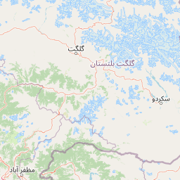
Map view of Astore Wildlife Sanctuary

Use this park location map to pinpoint Astore Wildlife Sanctuary in Pakistan, understand its exact geographic position, and read its mapped placement within the surrounding landscape more clearly.

Pigeon | © OpenStreetMap contributors

Location context for Astore Wildlife Sanctuary

Gilgit-Baltistan
Park atlas

Compare regional mountain habitats and connected high-altitude reserves in northern Pakistan.

Parks Near Astore Wildlife Sanctuary and Surrounding Protected Areas

Browse protected areas and high-mountain wildlife habitats located near Astore Wildlife Sanctuary in the western Karakoram. Comparing surrounding mountain reserves provides deeper geographical context into the ecological networks of Gilgit-Baltistan.
National parkGilgit-Baltistan
About 53 km away#1 closest

South

Nanga Parbat National Park: Protected Himalayan Landscape and Geographic Atlas

Explore mapped boundaries and alpine terrain in Gilgit-Baltistan.

Nanga Parbat National Park is a vast protected area defined by its spectacular Himalayan setting and dramatic alpine geography within Gilgit-Baltistan, Pakistan. As a national park, it safeguards the immense Nanga Parbat massif, its surrounding glaciers, and diverse altitudinal landscapes. This page offers an atlas perspective for understanding the park's geographic scope, its mapped natural features, and its significance as a protected mountain wilderness.

Area
1,785.61 km²
Established
2021
IUCN
II
Relief
Mountain
National parkGilgit-Baltistan
About 74 km away#2 closest

Southeast

Deosai National Park: A Premier High-Altitude Alpine Wilderness and Protected Landscape in Pakistan

Mapped boundaries and unique terrain within Gilgit-Baltistan's geography.

Deosai National Park is a key protected area in Pakistan's Gilgit-Baltistan region, characterized by its high-altitude alpine meadows and expansive plateau terrain. As a national park, it offers crucial insights into mapped landscapes and regional geography, particularly for understanding conservation efforts in extreme environments. The park's setting provides a unique lens through which to explore the distribution and characteristics of protected lands within the broader atlas of natural landscapes.

Area
3,584 km²
Established
1993
IUCN
Ib
Relief
Highland
National parkAzad Kashmir
About 81 km away#3 closest

Southwest

Ghamot National Park: Pakistan National Park Atlas and Protected Landscape

Explore mapped boundaries and regional geography in Azad Kashmir.

Ghamot National Park represents a cornerstone for protected area exploration in Pakistan, situated within the dramatic mountainous terrain of Azad Kashmir. As a national park, it is recognized for its critical function as a wildlife corridor, especially for the survival of the Himalayan Brown Bear, and harbors diverse avian populations. This page offers detailed insight into its geographic context and its significance within a broader regional conservation strategy, providing rich data for atlas-based discovery.

Established
2004
IUCN
II
Relief
Mountain
Access
Remote access
National parkPakistan
About 87 km away#4 closest

Southwest

Lulusar-Dudipatsar National Park: Pakistan's Dramatic Western Himalayan Protected Area

Explore alpine lakes, mountain scenery, and protected landscape geography.

Lulusar-Dudipatsar National Park stands as a remarkable protected landscape within Pakistan's Western Himalayas. The park's geography is defined by towering peaks and a series of pristine glacial lakes, including the iconic Dudipatsar and Lulusar lakes. Users can explore its mapped terrain and understand its significance as a high-altitude ecosystem and a key component of Pakistan's protected areas network.

Established
2003
IUCN
II
Relief
Mountain
Climate
Alpine
National parkPakistan
About 101 km away#5 closest

South

Gurez National Park: Pakistan's Alpine Protected Landscape and Wildlife Habitat

Explore its mapped terrain and regional geographic context.

Gurez National Park stands as a protected national park within Pakistan's breathtaking Himalayan mountain system. This park is crucial for conserving the endangered musk deer and safeguarding a fragile alpine ecosystem characterized by dramatic valleys, steep peaks, and the flowing Kishenganga River. Its relative isolation preserves a unique natural landscape and traditional cultural heritage, making it a point of interest for understanding remote wilderness and conservation efforts within the South Asian atlas.

IUCN
II
National parkGilgit-Baltistan
About 101 km away#6 closest

South

Himalaya National Park: Exploring Its Protected Boundaries and Mountainous Landscape in Gilgit-Baltistan

Mapped protected area within Pakistan's northern mountain region.

Himalaya National Park serves as a significant protected entity within the dramatic geography of Gilgit-Baltistan, Pakistan. This national park offers a focused view of its specific natural terrain and mapped boundaries, contributing to a broader atlas of conservation lands. Users can discover the park's role as a protected landscape, examining its integration within the regional context and understanding its unique geographic characteristics. The focus here is on the park's protected status and its place in the mapped natural environment of Northern Pakistan.

Area
2,263 km²
Established
2021
IUCN
II
Relief
Mountain
National parkKhyber Pakhtunkhwa
About 119 km away#7 closest

Southwest

Saiful Muluk National Park: Mapped Protected Landscape and Alpine Terrain in Pakistan

Discover the geography and protected boundaries of this Himalayan national park.

Saiful Muluk National Park in Khyber Pakhtunkhwa, Pakistan, is a key protected area characterized by its stunning alpine lake and dramatic Himalayan topography. This entry details the park's geographic scope, mapped landscape features, and its role as a critical national park. Understand the unique subalpine forests and meadow habitats that define this mountainous region and its protected status.

Area
880 km²
Established
2003
IUCN
II
Relief
Mountain
National parkGilgit-Baltistan
About 124 km away#8 closest

North

Qurumbar National Park: Pakistan's High-Altitude Protected Landscape and Geographic Atlas Point

Explore mapped alpine terrain, glacial features, and vital wildlife corridors.

Qurumbar National Park, situated in the rugged terrain of Gilgit-Baltistan, Pakistan, offers an unparalleled glimpse into a high-altitude protected landscape. This national park is defined by its dramatic alpine valleys, glacial features, and significant ecological value. As a key atlas point, it showcases the convergence of major Asian mountain systems and provides critical habitat for iconic mountain wildlife within its mapped boundaries.

Area
738 km²
Established
2011
IUCN
II
Relief
Mountain

Common questions about visiting, size, designation, and location context for Astore Wildlife Sanctuary

Astore Wildlife Sanctuary FAQs for park facts, access, geography, and protected area context

Find quick answers about Astore Wildlife Sanctuary, including protected-area facts, park geography, trail and visitor context, and how the park fits into its surrounding country and regional landscape.
MoriAtlas Explorer

Continue Your Protected Areas Search Across the Global Atlas

Deepen your exploration by continuing the structured search for national parks and protected areas worldwide. Utilize the comprehensive filtering capabilities to compare different conservation landscapes and refine your understanding of global park geography. Discover more about the distribution and characteristics of protected natural areas.

Global natural geography