

Mori Atlas logo
National parkBlackwood River National Park

Understand the mapped boundaries and regional geography of this national park.

Blackwood River National Park: A Protected Landscape in Western Australia

Blackwood River National Park represents a significant protected natural area within Western Australia, offering a distinct geographic identity. As a national park, its boundaries are meticulously mapped, providing a clear demarcation of its conservation landscape. This entry facilitates an atlas-driven understanding of the park's place within the broader regional geography of Western Australia, highlighting its role in the state's network of protected lands.

National ParkWestern AustraliaRiver EcosystemOld-Growth ForestJarrah ForestKarri Forest

Blackwood River National Park

National park

Park overview

Structured park overview, official facts, and landscape profile for Blackwood River National Park

Blackwood River National Park park facts, protected area profile, and essential visitor context
Review the core facts for Blackwood River National Park, including designation, size, terrain, visitor scale, habitats, and operating context in one park-focused overview.

About Blackwood River National Park

Blackwood River National Park occupies a meaningful position in Western Australia's protected area network as a conservation reserve established specifically to protect the middle reaches of the Blackwood River system. The river itself holds significant ecological importance as the largest river in South West Australia, originating on the regional plateau and flowing through a landscape of state forest before reaching the coast. The park's establishment in 2004 represented the culmination of planning efforts outlined in the Regional Forest Agreement for the South-West Forest Region of Western Australia and the Forest Management Plan 2004-2013, both of which identified the need for improved protection of old-growth forest ecosystems in the region. The park is bordered by Wiltshire-Butler National Park along its middle section to the north, with another unnamed national park adjoining the western boundary. The surrounding landscape consists predominantly of state forest lands that have been actively managed for timber production, making the national park designation an important addition to the regional conservation network. Visitors can access the park through two campgrounds, Warner Glen at the western end and Sues Bridge in the central portion, both providing direct river access for water-based recreation activities.

Quick facts and research context for Blackwood River National Park

Blackwood River National Park covers 204.75 square kilometers along the middle course of the Blackwood River in Western Australia's South West region. The park was officially designated in 2004 through legislation that redesignated lands from four former state forests into national park status. It is managed by the Parks and Wildlife Service of the Department of Biodiversity, Conservation and Attractions. The park provides habitat across two distinct bioregions, with the Jarrah Forest bioregion representing Southwest Australia woodlands in the northern portion and the Warren bioregion encompassing jarrah-karri forest and shrublands in the southern areas. The Blackwood River itself is the largest river in South West Australia, originating on the plateau and flowing westward through the park before turning south to reach the Southern Ocean.

Park context

Deeper park guide and search-rich context for Blackwood River National Park

Blackwood River National Park history, landscape, wildlife, and travel context
Explore Blackwood River National Park through its history, landscape character, ecosystems, wildlife, conservation priorities, cultural context, and seasonal travel timing in a structured park guide built for atlas discovery and search intent.

Why Blackwood River National Park stands out

Blackwood River National Park is best known for protecting the middle reach of the Blackwood River, the most significant river system in South West Australia. The park preserves a corridor of riparian and adjacent forest habitats where the river transitions from its plateau source across the landscape before entering the Southern Ocean. It encompasses old-growth forest habitats within two bioregions, representing the convergence of the Southwest Australia woodlands and the jarrah-karri forest and shrublands. The park provides recreational opportunities centered on the river, with campgrounds offering swimming access and canoe or kayak launching facilities.

Blackwood River National Park history and protected-area timeline

Blackwood River National Park was established in 2004 through the Reserves (National Parks, Conservation Parks, and Nature Reserves) Bill 2004, which restructured land tenure across portions of the South West forest region. The creation of this national park was specifically recommended in the Regional Forest Agreement for the South-West Forest Region of Western Australia, published in May 1999, which identified gaps in the existing protected area network for old-growth forest conservation. The land comprising the new national park was previously designated as state forest, with the legislation redesignating lands from four separate state forest areas to create the new protected area. This process aligned with the broader Forest Management Plan 2004-2013, which outlined a strategy for improving conservation outcomes for old-growth forests through national park establishment. The formal designation marked a significant step in balancing forest conservation with other land uses in the South West region of Western Australia.

Blackwood River National Park landscape and geographic character

The landscape of Blackwood River National Park is defined by its position along the middle reaches of the Blackwood River as it flows westward across the South West region before turning south toward the Southern Ocean. The terrain through the park consists of valley systems carved by the river, with the surrounding landscape characterized by undulating hills and forested slopes typical of the South West Australian landscape. The park is situated within a matrix of state forest lands, with Blackwood State Forest, South Blackwood State Forest, and Milyeannup State Forest surrounding the protected area on multiple sides. The river itself provides a linear watercourse feature through the park, with riparian corridors of vegetation following its banks. The park sits at the interface between the plateau landscapes where the river originates and the lower-lying coastal plain areas as the river makes its way toward the Southern Ocean.

Blackwood River National Park ecosystems, habitats, and plant life

The ecological character of Blackwood River National Park is defined by its position spanning two significant bioregions of South West Australia. The northern portion of the park falls within the Jarrah Forest bioregion, also known as the Southwest Australia woodlands, characterized by jarrah-dominated open forest and woodland communities adapted to the region's Mediterranean climate. The southern portion of the park lies within the Warren bioregion, also referred to as the jarrah-karri forest and shrublands, where the vegetation includes both jarrah and karri tree species, creating taller and denser forest structures. This bioregional transition creates a diversity of habitat types within the park, from open woodlands on the more elevated terrain to denser forest in the riparian zones and lower-lying areas. The Blackwood River corridor itself provides additional habitat diversity, supporting riparian vegetation communities distinct from the surrounding forest types.

Blackwood River National Park wildlife and species highlights

The wildlife of Blackwood River National Park is supported by the diverse forest and riparian habitats created by the intersection of two bioregions and the Blackwood River corridor. The jarrah and karri forests provide habitat for numerous bird species, mammals, and invertebrates characteristic of South West Australian forests. The river itself supports aquatic fauna adapted to the region's river systems, and the riparian zones provide important habitat for species that depend on the interface between aquatic and terrestrial environments. The old-growth forest elements present within the park, which were a primary motivation for its designation, provide critical habitat for species that require mature forest structures for nesting, foraging, or shelter. The conservation of this corridor through national park protection helps maintain connectivity for wildlife movement through the broader landscape.

Blackwood River National Park conservation status and protection priorities

Blackwood River National Park represents an important addition to Western Australia's conservation estate, specifically established to protect old-growth forest habitats within the South West forest region. The park was created as part of a systematic approach to addressing conservation gaps identified in the Regional Forest Agreement, which recognized that existing protected area coverage was insufficient for maintaining viable populations of old-growth forest dependent species. The transition from state forest to national park status provides these lands with stronger legal protection and management focused on conservation outcomes rather than timber production. The park contributes to the broader regional conservation network, connecting with adjacent protected areas including Wiltshire-Butler National Park and contributing to landscape-scale conservation planning across the South West region. The protection of the Blackwood River corridor also provides aquatic ecosystem benefits, helping preserve water quality and habitat for river-dependent species.

Blackwood River National Park cultural meaning and human context

The Blackwood River has long been significant to the local communities of the South West region of Western Australia, with the river system providing water, food resources, and transportation routes for Indigenous peoples historically. The Augusta-Margaret River and Nannup areas have cultural connections to Noongar people, whose traditional lands encompass the broader South West region. The establishment of Blackwood River National Park as a conservation reserve contributes to ongoing efforts to recognize and protect cultural and natural heritage values across the landscape. The surrounding state forest lands have historically been managed for timber production, and the creation of the national park represents a recognition that some areas hold higher conservation and cultural values than production potential.

Top sights and standout views in Blackwood River National Park

The middle reach of the Blackwood River, the largest river in South West Australia, forms the central feature of this national park, providing a scenic and ecological spine through the protected area. Two campgrounds, Warner Glen and Sues Bridge, provide visitor access to the river for swimming, canoeing, and kayaking activities. The park spans two bioregions, offering a transition from Jarrah Forest woodlands in the north to Warren bioregion jarrah-karri forest in the south. The old-growth forest communities that prompted the park's establishment represent significant conservation values for the South West region. Connection to adjacent protected areas including Wiltshire-Butler National Park creates a larger conservation landscape through this portion of Western Australia.

Best time to visit Blackwood River National Park

The South West region of Western Australia experiences a Mediterranean climate with wet winters and warm, dry summers, which influences the best conditions for visiting Blackwood River National Park. The summer months from December through February typically offer warm conditions suitable for swimming and water-based activities on the river, though visitors should be aware that bushfire risk increases during the hot summer period. Autumn and spring provide mild temperatures and the opportunity to experience the forest during different seasonal conditions. Winter brings rainfall that can affect access and road conditions within the park, though the forest landscapes take on a different character during the wet season. The shoulder seasons of spring and autumn often provide comfortable conditions for bushwalking and exploring the park's natural values.
Park location guide

Geography guide, regional context, and park location map for Blackwood River National Park

Blackwood River National Park park geography, regions, and map view in Australia
Understand where Blackwood River National Park sits in Australia through a broader geographic reading of the surrounding landscape, nearby location context, and its mapped position within the national park landscape.

How Blackwood River National Park fits into Australia

Australia is a constitutional monarchy and federal parliamentary democracy comprising six states and ten territories. With a population of nearly 28 million, it is one of the world's most urbanised countries, with most people concentrated on the eastern seaboard. The country has a high Human Development Index and is known for its cultural diversity, ancient Aboriginal heritage, and unique wildlife.

Wider geography shaping Blackwood River National Park in Australia

Australia occupies the entire Australian continent, the island of Tasmania, and numerous smaller islands. It is the world's flattest and driest inhabited continent, featuring vast deserts in the interior (the Outback), tropical rainforests along the eastern coast, and a coastline bordering the Indian and Pacific Oceans.

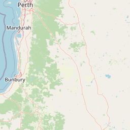
Map view of Blackwood River National Park

Use this park location map to pinpoint Blackwood River National Park in Australia, understand its exact geographic position, and read its mapped placement within the surrounding landscape more clearly.

Pigeon | © OpenStreetMap contributors

Location context for Blackwood River National Park

Western Australia
Park atlas

Discover Connected Protected Landscapes and Diverse Forest Bioregions Across Western Australia's South West.

Explore Other National Parks and Protected Areas Near Blackwood River National Park in Western Australia
After exploring Blackwood River National Park, continue your geographic discovery by browsing other national parks and protected areas across Western Australia's South West region. Compare diverse protected landscapes, river ecosystems, and old-growth forest habitats to understand broader conservation patterns and regional park geography.
National park

Wiltshire-Butler National Park: Mapped Jarrah Forest Landscape in Western Australia

Explore protected boundaries and regional geographic context

Wiltshire-Butler National Park stands as a protected natural area celebrated for its representation of Western Australia's iconic jarrah forest ecosystems. This National Park, created in 2004, offers rich opportunities for atlas-based discovery, focusing on its distinct landscape character, mapped park boundaries, and its geographical placement within the broader South West region. Understanding its terrain and conservation significance provides valuable insight into the protected lands of the Jarrah Forest bioregion.

Area
116.45 km²
Established
2004
IUCN
II
Relief
Highland
National parkAustralia

Milyeannup National Park: Explore its Protected Landscape and Geographic Atlas Context

Discover the mapped terrain and boundaries of this Australian national park.

Milyeannup National Park offers a unique focus for atlas-based geographic exploration. This entry details the park's identity as a protected area, highlighting its landscape context and mapped geographic features within Australia. Use this resource to understand its role in the national park system and its specific place within the broader landscape.

Area
186.92 km²
Established
2004
Scope
Terrestrial
Forest
Mostly forested
National parkWestern Australia

Scott National Park National Park: Mapped Protected Landscape in Western Australia

Geographic Context and Natural Terrain Discovery

Scott National Park serves as a significant protected area within the diverse geography of Western Australia. This national park provides a focal point for understanding regional landscape patterns and mapped natural features. Explore its role as a protected land, offering insight into the state's broad natural heritage and supporting detailed geographic discovery for atlas enthusiasts.

Area
32.73 km²
Established
1959
IUCN
II
Relief
Lowland
National park

Forest Grove National Park: Mapped Boundaries of a Jarrah Forest Protected Landscape

Western Australia's National Park in the Margaret River Region.

Forest Grove National Park represents a vital protected area within Western Australia's Jarrah Forest bioregion, offering a clear look at the characteristic tall open forest and woodland ecosystems of the region. While nearby areas are known for their dramatic coastlines, this national park highlights the inland natural terrain and its unique ecological importance. Its mapped boundaries are integral to understanding the contiguous forest corridors developed to preserve these valuable Southwest Australian habitats.

Area
13.79 km²
Established
2004
Relief
Lowland
Climate
Temperate
National park

Hilliger National Park: Western Australian Protected Jarrah Forest and Memorial Landscape

Mapped boundaries of a vital national park in the South West region.

Hilliger National Park stands as a testament to forest conservation in Western Australia's South West. This 16,962-hectare national park, established in 2004, protects representative old-growth jarrah forest ecosystems and honors a significant firefighting legacy. Explore its terrain and its geographic placement within a broader network of protected lands, offering a concrete example of conservation strategy in the region. The park's mapped area contributes valuable data to the understanding of regional natural landscapes.

Area
169.62 km²
Established
2004
Climate
Temperate
Scope
Terrestrial
National parkWestern Australia

Wooditjup National Park: Protected Forest Landscape and Regional Geographic Context

Explore mapped boundaries of this Western Australia national park.

Wooditjup National Park stands as a testament to Western Australia's unique forest ecosystems, specifically within the Jarrah Forest bioregion. This protected area offers a distinct natural landscape contrasting with the nearby coastal attractions of Margaret River. Delve into the park's mapped geography, understand its role as a national park, and appreciate its position within the broader South West Australian landscape and its traditional Wardandi Country heritage.

Area
38.92 km²
Established
2004
IUCN
II
Relief
Lowland
National parkWestern Australia

Easter National Park: Protected Jarrah Forest Landscape Atlas

Explore its mapped terrain and regional geography.

Easter National Park serves as a protected national park in Western Australia, preserving crucial jarrah forest ecosystems within the Warren bioregion. As part of the Southwest Australia biodiversity hotspot, it contributes to a contiguous block of protected land safeguarding the region's distinctive woodland and forest communities. Users can explore its mapped boundaries and understand its role within the broader South West Australian geography, offering a detailed look at a representative forest reserve.

Area
29.85 km²
Established
2004
IUCN
II
Relief
Lowland
National parkWestern Australia

Leeuwin-Naturaliste National Park: Western Australia's Protected Landscape and Geographic Context

Explore mapped natural terrain and protected boundaries.

Leeuwin-Naturaliste National Park provides a distinct focus for understanding protected lands within Western Australia. This national park offers rich opportunities to examine its mapped boundaries and unique landscape characteristics, contributing valuable context to the regional geography of the state. Discover the natural terrain and protected area status that define this significant location for atlas-based discovery and geographic comprehension.

Area
190.92 km²
Established
1957
IUCN
II
Visitors
2.3M annual

Common questions about visiting, size, designation, and location context for Blackwood River National Park

Blackwood River National Park FAQs for park facts, access, geography, and protected area context
Find quick answers about Blackwood River National Park, including protected-area facts, park geography, trail and visitor context, and how the park fits into its surrounding country and regional landscape.
MoriAtlas Explorer

Continue Your Protected Areas Search Across the Global Atlas

Deepen your exploration by continuing the structured search for national parks and protected areas worldwide. Utilize the comprehensive filtering capabilities to compare different conservation landscapes and refine your understanding of global park geography. Discover more about the distribution and characteristics of protected natural areas.

Global natural geography