Mori Atlas logo
Nature reserveBretti Nature Reserve

Mapping the ecological connectivity of wet sclerophyll forests and river corridors in New South Wales

Bretti Nature Reserve and the Protected Forest Landscapes of the Great Eastern Escarpment

Bretti Nature Reserve represents a critical protected link within the Great Dividing Range, spanning the transition between elevated tablelands and the coastal lowlands of New South Wales. This atlas detail examines the reserve's unique mosaic of wet sclerophyll forest and subtropical rainforest patches, anchored by the confluence of the Bernard and Manning Rivers. The terrain serves as a vital ecological corridor, tracing the rugged escarpment topography that defines this section of the Australian eastern mountain spine.

strict nature reservewet sclerophyll foresttemperate rainforestGreat Dividing RangeGreat Eastern Escarpmentriver landscape

Bretti Nature Reserve

Nature reserve

Park overview

Structured park overview, official facts, and landscape profile for Bretti Nature Reserve

Bretti Nature Reserve park facts, protected area profile, and essential visitor context

Review the core facts for Bretti Nature Reserve, including designation, size, terrain, visitor scale, habitats, and operating context in one park-focused overview.

About Bretti Nature Reserve

Bretti Nature Reserve is a compact protected area with an outsized conservation role. Set in the rugged foothills north of Gloucester in the Hunter Region of New South Wales, it adjoins the wider Barrington Tops landscape and forms part of a long chain of protected forests stretching along the Great Eastern Escarpment of the Great Dividing Range. The reserve's mix of wet sclerophyll eucalyptus forest, subtropical rainforest remnant, and riverine habitat gives it an ecological character that contrasts with the drier, more open forests found elsewhere in the surrounding lowlands.

The reserve's establishment in January 1999 brought these ecosystems under formal protection and recognised their value as a stepping stone between larger wilderness areas to the north and south. As part of the Curracabundi Group, the reserve contributes to a wider landscape-scale conservation initiative aiming to keep mountain ecosystems connected along eastern Australia. This status as a strict nature reserve, the most restrictive IUCN-aligned category used in New South Wales, signals that the area is managed chiefly for ecological and scientific values rather than for intensive public use or development.

For visitors, the reserve is most readily experienced through its scenery along Thunderbolts Way, which threads between towering eucalypts and old figs, and through the riverside camp on the Bernard River near its meeting with the Manning River. Despite its modest footprint, Bretti Nature Reserve rewards those who pause to look and listen, offering a concentrated expression of the wet forests, birdlife, and river country that define this stretch of the Australian escarpment.

Quick facts and research context for Bretti Nature Reserve

Bretti Nature Reserve is a strict nature reserve of around 29 square kilometres in the Hunter Region of New South Wales, located roughly 30 kilometres north of Gloucester near the southern edge of the Barrington Tops uplift. Established in 1999 and managed by the NSW National Parks and Wildlife Service, the reserve protects wet sclerophyll eucalyptus forest and rainforest on the slopes and gullies of the Great Eastern Escarpment.

It is one of the constituent protected areas of the Curracabundi Group, a corridor of wilderness and nature reserves designed to link mountain ecosystems along the length of eastern Australia. The reserve's most prominent natural feature is the Bernard River valley, where the river meets the Manning River. Access is closely tied to Thunderbolts Way, the scenic touring road that cuts through the reserve.

Protection and recognition

Examine the documented conservation scope and international recognition records for Bretti Nature Reserve.

Bretti Nature Reserve Protection Status and Territorial Designation Facts

Terrestrial conservation frameworks establish the official protection status and management scope recorded for Bretti Nature Reserve. Structured territorial facts outline the documented designation history and international recognition metrics associated with the reserve.

Protection details

Protection scope
Terrestrial
Transboundary protection
No
Park context

Deeper park guide and search-rich context for Bretti Nature Reserve

Bretti Nature Reserve history, landscape, wildlife, and travel context

Explore Bretti Nature Reserve through its history, landscape character, ecosystems, wildlife, conservation priorities, cultural context, and seasonal travel timing in a structured park guide built for atlas discovery and search intent.

Why Bretti Nature Reserve stands out

Bretti Nature Reserve is best known for protecting a vibrant mosaic of wet sclerophyll forest and temperate rainforest on the Great Eastern Escarpment, and for serving as a quiet but vital ecological link in the Curracabundi Group of reserves. Its rainforest patches harbour the locally rare wompoo fruit dove, one of the more distinctive tropical-subtropical bird species reaching this far south in eastern Australia. The reserve is also well known among travellers for the scenic stretch of Thunderbolts Way that winds through it, framed by ancient figs and tall eucalypts. Less widely known but equally important is the reserve's river landscape: the Bernard River and its junction with the Manning River create a forested riparian corridor that supports rich wildlife habitat and anchors the reserve's most visited area, a riverside campground.
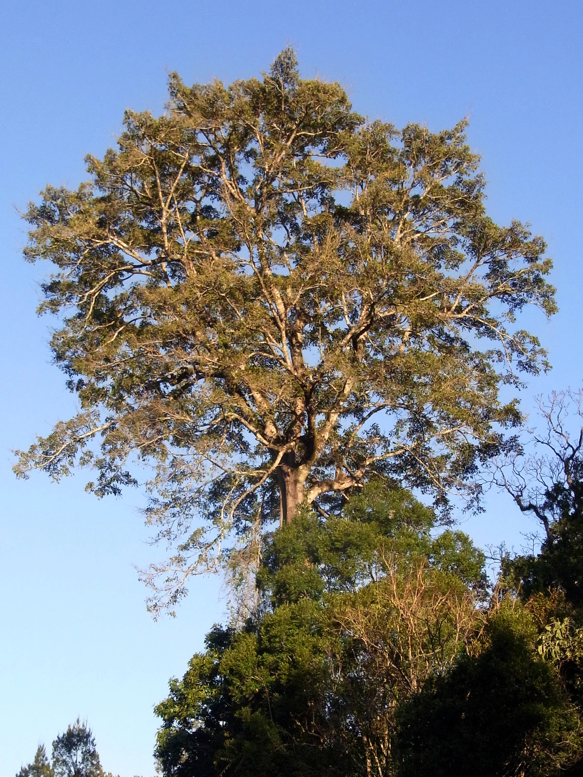
A large, tall tree with a dense canopy reaching into a clear blue sky, towering over surrounding smaller trees.
A prominent Ficus obliqua tree rising above the forest canopy in Bretti Nature Reserve.

Bretti Nature Reserve history and protected-area timeline

The Bretti Nature Reserve was gazetted in January 1999, bringing an area of wet sclerophyll forest, rainforest, and Bernard River gorge country under formal protection in the Hunter Region of New South Wales. Its creation formed part of a broader effort during the late twentieth century to consolidate fragmented forest reserves along the Great Eastern Escarpment into a continuous conservation system rather than isolated patches.

The reserve subsequently became one of the constituent protected areas of the Curracabundi Group, a collaborative initiative that links wilderness and nature reserves along the length of the Great Dividing Range in eastern Australia. This grouping reflects an evolving conservation philosophy in New South Wales: recognising that highland and escarpment ecosystems, many of which are relicts from cooler and wetter climatic periods, require large, connected landscapes to maintain viable populations of sensitive species. The reserve has been managed continuously by the NSW National Parks and Wildlife Service, with emphasis on retaining its strict nature reserve character and minimising infrastructure development within its boundaries.

Bretti Nature Reserve landscape and geographic character

The landscape of Bretti Nature Reserve is shaped by the dramatic transition from the cool, elevated tablelands of Barrington Tops to the warmer coastal lowlands of the Manning River valley. The reserve occupies a section of this steep eastern fall, where the Great Dividing Range splinters into a series of ridges, spurs, and deeply cut river gorges. Elevations vary enough to support clearly distinct vegetation zones across a relatively small footprint.

The Bernard River corridor is the reserve's most striking physical feature, carving a forested valley through the escarpment slopes before joining the Manning River near the reserve's edge. Along this valley, the terrain narrows into shaded gullies and opens into broader alluvial flats near the river junction. The escarpment context also creates the moist, sheltered conditions that allow small rainforest patches to persist amid the dominant eucalypt forests, an unusual juxtaposition that gives the reserve much of its visual and ecological richness.

Bretti Nature Reserve ecosystems, habitats, and plant life

Ecologically, Bretti Nature Reserve is defined by the interplay between wet sclerophyll eucalyptus forest and remnant temperate rainforest, two forest types that share space across the slopes and gullies of the eastern escarpment. Tall mesic eucalypts dominate the broader hillsides, their canopies interspersed with a diverse understorey, while pockets of subtropical and warm temperate rainforest cling to the most sheltered, moisture-retaining sites along the river valleys and lower slopes.

This combination produces a structurally complex forest where open-canopied eucalypt woodland transitions abruptly into dense, layered rainforest within short distances. Such mosaics are increasingly rare in heavily cleared eastern Australia, making the reserve a refuge for species that rely on stable, humid microclimates. The Bernard River and its tributaries further enhance ecological diversity by creating permanently moist riparian zones that sustain amphibian, reptile, and invertebrate populations alongside the forest fauna.

Bretti Nature Reserve wildlife and species highlights

The reserve's mix of wet sclerophyll forest and rainforest supports a varied fauna typical of the Barrington Tops foothills. Most distinctive among the reserve's birds is the wompoo fruit dove, a large, colourful pigeon normally associated with subtropical rainforests further north; its presence at Bretti marks the area as one of the more southerly reliable locations in New South Wales for this species, and its deep, resonant call is often what visitors notice first in the rainforest patches.

Beyond this signature species, the reserve provides habitat for the typical upland-escarpment birdlife of the region, including honeyeaters, robins, fantails, and various parrots that move through the eucalypt canopy. The dense rainforest and riverine vegetation also support a healthy population of small mammals, reptiles, and amphibians, with the Bernard River corridor acting as a key movement and foraging pathway. Because the reserve is managed as a strict nature reserve, disturbance is minimal, allowing wildlife to behave in ways less constrained than in more frequently visited parks.

Bretti Nature Reserve conservation status and protection priorities

Bretti Nature Reserve is significant from a conservation perspective both for what it protects locally and for where it sits in the broader landscape. Classified as a strict nature reserve under the IUCN system, it receives the highest level of nature protection available in New South Wales, with management prioritising ecological integrity, scientific reference values, and the preservation of natural processes over recreation or infrastructure.

The reserve is one of the core building blocks of the Curracabundi Group, a network of protected areas strung along the Great Eastern Escarpment that aims to connect mountain ecosystems over very long distances. This landscape-scale role gives Bretti a conservation weight greater than its individual area would suggest: by protecting forest cover and river habitat between larger reserves to the north and south, it helps maintain ecological connectivity, supports genetic exchange in wildlife populations, and buffers the resilience of escarpment forests against climate and land-use pressures further down the range.

Top sights and standout views in Bretti Nature Reserve

The standout qualities of Bretti Nature Reserve lie in the combination of wet forest, rainforest remnants, and river scenery packed into a small, carefully protected footprint. The rainforest patches, the constant presence of the Bernard River, and the chance to hear the wompoo fruit dove calling from the canopy all combine to give the reserve a distinctly subtropical, escarpment-gorge character that contrasts with the drier forests typically associated with New South Wales.

Equally important is the reserve's role as a connected piece of a much larger conservation puzzle along the Great Dividing Range, and its accessibility via Thunderbolts Way, which threads through some of its most scenic forest. These qualities together make Bretti a quiet but deeply characteristic example of eastern Australia's wet escarpment country.

Monthly climate preview

Long-term representative monthly temperature and precipitation data for Bretti Nature Reserve

Bretti Nature Reserve Climate Normals and Annual Weather Patterns

Bretti Nature Reserve exhibits a measured annual temperature and precipitation rhythm across twelve recorded months. Analyzing these long-term climate normals reveals detailed monthly variations in average minimum and maximum temperatures alongside daily rainfall averages.
Annual mean15 °C
8 °C21 °C
Jan21°
Feb20°
Mar18°
Apr15°
May11°
Jun
Jul
Aug
Sep12°
Oct15°
Nov18°
Dec20°
Warmest month
January

21.1 °C

Coolest month
July

8 °C

Wettest month
February

4.9 mm/day

Driest month
July

1.5 mm/day

Park location guide

Geography guide, regional context, and park location map for Bretti Nature Reserve

Bretti Nature Reserve park geography, regions, and map view in Australia

Understand where Bretti Nature Reserve sits in Australia through a broader geographic reading of the surrounding landscape, nearby location context, and its mapped position within the national park landscape.

How Bretti Nature Reserve fits into Australia

Australia is a constitutional monarchy and federal parliamentary democracy comprising six states and ten territories. With a population of nearly 28 million, it is one of the world's most urbanised countries, with most people concentrated on the eastern seaboard. The country has a high Human Development Index and is known for its cultural diversity, ancient Aboriginal heritage, and unique wildlife.

Wider geography shaping Bretti Nature Reserve in Australia

Australia occupies the entire Australian continent, the island of Tasmania, and numerous smaller islands. It is the world's flattest and driest inhabited continent, featuring vast deserts in the interior (the Outback), tropical rainforests along the eastern coast, and a coastline bordering the Indian and Pacific Oceans.

Map view of Bretti Nature Reserve

Use this park location map to pinpoint Bretti Nature Reserve in Australia, understand its exact geographic position, and read its mapped placement within the surrounding landscape more clearly.

Pigeon | © OpenStreetMap contributors

Location context for Bretti Nature Reserve

New South Wales

Explore protected area scenery, river valleys, and wet sclerophyll forest habitats.

Bretti Nature Reserve Photos and Landscapes: Visualizing the Escarpment Forest

Visual records reveal the steep terrain, river corridors, and rainforest patches that define Bretti Nature Reserve. Examining these protected landscapes helps observers understand the ecological transition zones spanning the eastern escarpment.

A large, tall tree with a dense canopy reaching into a clear blue sky, towering over surrounding smaller trees.

Park atlas

Compare surrounding escarpment forests and connected river corridors across the region

Explore Protected Areas and National Parks Near Bretti Nature Reserve

Browsing other protected areas near Bretti Nature Reserve reveals the wider ecological patterns of the Great Dividing Range escarpment. Examining adjacent forest reserves and mountain parks provides valuable context for understanding regional conservation networks.
National parkNew South Wales
About 4.8 km away#1 closest

West

Woko National Park: Explore Its Protected Landscape and Geographic Boundaries

Discover the mapped terrain and regional atlas context of Woko National Park.

Woko National Park presents a unique opportunity for geographic discovery, situated within New South Wales, Australia. This detail page focuses on the park's protected landscape and its mapped boundaries, providing a clear understanding of its geographic identity. Engage with Woko National Park as a key component of the Australian national park atlas, highlighting its regional setting and natural terrain.

Area
85.98 km²
Established
1982
IUCN
II
Relief
Highland
National parkNew South Wales
About 5.2 km away#2 closest

North

Barakee National Park: New South Wales Protected Landscape Atlas Explorer

Mapped Boundaries and Regional Geography Insights

Barakee National Park is a vital component of New South Wales's protected natural areas, offering a focused point for geographic discovery. This page provides key details on its protected landscape identity and its place within the mapped terrain of the region. Examine the structured data to grasp the park's geographic footprint and understand its significance as a designated national park within Australia.

Area
50.11 km²
Established
1999
IUCN
II
Relief
Mixed relief
National parkMid North Coast
About 19 km away#3 closest

East

Tapin Tops National Park: Protected Landscape in Mid North Coast, Australia

Mapped geographic context and natural terrain discovery.

Tapin Tops National Park is a designated national park offering rich opportunities for geographic and landscape exploration. This detail page provides a structured look at its protected area status and its location within the Mid North Coast region of Australia. Delve into the mapped boundaries and understand the park's specific natural terrain for comprehensive atlas-based discovery.

Area
110 km²
Established
1999
IUCN
II
Relief
Mountain
National parkNew South Wales
About 21 km away#4 closest

Northwest

Nowendoc National Park: Protected Area Identity and New South Wales Geography

Mapping the natural landscapes and protected boundaries within this national park.

Nowendoc National Park in New South Wales, Australia, offers a distinct protected landscape for atlas-driven discovery. This entry provides critical geographic context, detailing the park's mapped boundaries and its place within the regional terrain. Explore the specific identity of Nowendoc National Park as a protected natural area, crucial for understanding Australian conservation landscapes and geographic context.

Area
88 km²
Established
1999
IUCN
II
Relief
Upland
A soft watercolor painting of a forest landscape with slender trees and grasses, rendered in light green, pink, and neutral tones.
State or regional parkNew South Wales
About 25 km away#5 closest

South

Copeland Tops State Conservation Area: Geography and Protected Land Overview in New South Wales

Mapping forest ecosystems and historic industrial relic landscapes.

Copeland Tops State Conservation Area provides a distinct look at the Hunter Region landscape, offering an unusual blend of dry rainforests with massive Moreton Bay figs and red cedar alongside expansive wet sclerophyll forests. The reserve functions as an essential habitat for koalas, wombats, and greater gliders, while the Mountain Maid gold mine remnants offer insight into the local nineteenth century history hidden within these sheltered valleys.

Area
22.01 km²
Established
2003
Relief
Upland
Scope
Terrestrial
A horizontal watercolor painting depicting a soft landscape with distant purple hills, a meandering stream, and green grassy foreground vegetation.
Protected areaNew South Wales
About 27 km away#6 closest

Southwest

Barrington Tops State Conservation Area: Protected Plateau and Volcanic Landscape Context

Highland geography within the Mount Royal Range, New South Wales

This protected area represents a significant upland region in New South Wales, characterized by weathered plateau edges and cool mountain environments. The terrain supports high-altitude peat wetlands and diverse montane forests, rooted in the ancient geological legacy of the Barrington Volcano. Its protected boundaries link directly to the Gondwana Rainforests, providing essential habitat continuity across the Great Dividing Range.

Area
84.46 km²
Established
2003
Relief
Mountain
Climate
Temperate
National parkNew South Wales
About 30 km away#7 closest

Northeast

Cottan-Bimbang National Park: A Protected Landscape in New South Wales

Explore its mapped boundaries and regional geographic context.

Delve into the protected landscape of Cottan-Bimbang National Park, a key national park situated in New South Wales, Australia. This page provides detailed insight into its geographic setting and mapped park boundaries, offering a clear understanding of its regional importance. Discover the distinct natural landscape characteristics that define Cottan-Bimbang National Park within the broader Australian atlas.

Area
269 km²
Established
1999
IUCN
II
Climate
Temperate
National parkNew South Wales
About 31 km away#8 closest

North

Mummel Gulf National Park: New South Wales Protected Area & Mapped Gorge Landscape

Rugged escarpment terrain with diverse forest ecosystems.

Mummel Gulf National Park is a protected area in New South Wales, Australia, renowned for its dramatic V-shaped gorge carved by the Mummel River, reaching depths over 400 metres. This rugged escarpment landscape hosts a variety of vegetation communities, including tall open eucalypt, wet sclerophyll, snow gum forests, and subtropical rainforest patches. The park's geography is central to its ecological significance, providing habitat for numerous species and showcasing a distinct natural terrain within the New England region, ideal for geographic exploration.

Area
122 km²
Established
1999
IUCN
II
Relief
Mountain

Common questions about visiting, size, designation, and location context for Bretti Nature Reserve

Bretti Nature Reserve FAQs for park facts, access, geography, and protected area context

Find quick answers about Bretti Nature Reserve, including protected-area facts, park geography, trail and visitor context, and how the park fits into its surrounding country and regional landscape.
MoriAtlas Explorer

Continue Your Protected Areas Search Across the Global Atlas

Deepen your exploration by continuing the structured search for national parks and protected areas worldwide. Utilize the comprehensive filtering capabilities to compare different conservation landscapes and refine your understanding of global park geography. Discover more about the distribution and characteristics of protected natural areas.

Global natural geography