

Mori Atlas logo
National parkChambi National Park

Examine the elevation, forested slopes, and mountain ridges of this vital North African conservation area

Chambi National Park: Mapping the Protected Mountain Landscapes and Geography of West Central Tunisia

Chambi National Park protects the dramatic terrain surrounding Djebel Chambi, the highest peak in Tunisia. This atlas entry details the geography of the Kasserine Governorate, focusing on the steep rocky slopes, semi-arid vegetation zones, and the protected habitats within the Mont de Tebessa massif. Analyze the topographical relief and environmental significance of this critical Mediterranean mountain ecosystem.

mountain ecosystemendangered species habitatUNESCO biosphere reserveNorth AfricaCuvier's gazelle refugeBarbary sheep

Chambi National Park

National park

Park overview

Structured park overview, official facts, and landscape profile for Chambi National Park

Chambi National Park park facts, protected area profile, and essential visitor context

Review the core facts for Chambi National Park, including designation, size, terrain, visitor scale, habitats, and operating context in one park-focused overview.

About Chambi National Park

Chambi National Park protects a mountainous landscape of considerable ecological and geographical importance in Tunisia. Located in the west-central region of the country within the Kasserine Governorate, the park encompasses the slopes and summit of Djebel Chambi, Tunisia's highest mountain at 1,544 meters above sea level. The protected area lies close to the Algerian border and forms part of the Mont de Tebessa forest massif, a mountain range that extends across the border region. The terrain consists of rugged slopes, rocky outcrops, and forested areas that transition from Mediterranean-type vegetation at lower elevations to more sparse, drought-resistant plant communities at higher altitudes. The park's ecological character is defined by its position at the intersection of North African and Mediterranean biogeographical zones, supporting a mix of species adapted to both semi-arid and more temperate conditions. Without permanent rivers or streams, the park's water systems rely entirely on seasonal rainfall and underground aquifers, making the ecosystem particularly sensitive to climatic variations.

Quick facts and research context for Chambi National Park

Chambi National Park occupies 67.23 square kilometers in the Kasserine Governorate of west-central Tunisia, near the Algerian border. The park was formally established in 1980, though conservation efforts began earlier with a 300-hectare fenced reserve for Cuvier's gazelle created in 1970. Mount Chambi (Djebel Chambi) rises to 1,544 meters as Tunisia's tallest mountain, forming the park's central geographical feature. The area is part of the Mont de Tebessa forest massif, a mountainous region spanning the border zone between Tunisia and Algeria. The park has no permanent watercourses, relying instead on seasonal precipitation and groundwater systems.

Protection and recognition

Terrestrial protected area management scope and administrative records

Chambi National Park Protection Status and Conservation Recognition

Chambi National Park protection status details the documented terrestrial scope and administrative framework governing the protected area. Structured conservation records compile official designation history and international recognition data without assuming management outcomes.

Protection details

Protection scope
Terrestrial
Transboundary protection
No
Park context

Deeper park guide and search-rich context for Chambi National Park

Chambi National Park history, landscape, wildlife, and travel context

Explore Chambi National Park through its history, landscape character, ecosystems, wildlife, conservation priorities, cultural context, and seasonal travel timing in a structured park guide built for atlas discovery and search intent.

Why Chambi National Park stands out

Chambi National Park is best known for protecting Tunisia's highest mountain and serving as one of the last remaining habitats for the endangered Cuvier's gazelle, a species now rare across North Africa. The park also supports populations of Barbary sheep, a vulnerable mountain-dwelling antelope species. Its significance extends to ornithology, with notable bird species including the Tunisian crossbill, Egyptian vulture, Bonelli's eagle, and peregrine falcon. The combination of high-altitude ecosystems, endangered mammal species, and the presence of endemic flora makes this park a critical conservation area in the Mediterranean region.
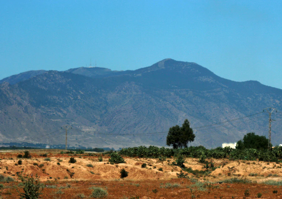
Djebel Chambi mountain visible in the distance with arid landscape and scattered vegetation in the foreground under a clear blue sky
Djebel Chambi mountain range in Chambi National Park, Tunisia

Chambi National Park history and protected-area timeline

Conservation at Chambi began in 1970 when a 300-hectare fenced reserve was established specifically to protect populations of Cuvier's gazelle, which had become increasingly endangered across its range. This early protection effort recognized the critical importance of the Mount Chambi area as a refuge for this species. In 1977, the park and its surrounding areas received international recognition when they were designated a UNESCO biosphere reserve, acknowledging both the ecological significance and the need for coordinated conservation management. The formal establishment of Chambi National Park followed in 1980, expanding the protected area to its current extent of 6,723 hectares and providing stronger legal framework for the preservation of the region's unique ecosystems and endangered species.

Chambi National Park landscape and geographic character

The landscape of Chambi National Park is dominated by Djebel Chambi, a prominent mountain that rises dramatically from the surrounding plains of west-central Tunisia. The terrain is characterized by steep rocky slopes, mountain ridges, and forested valleys that create a varied topography within a relatively compact protected area. The mountain's elevation of 1,544 meters provides significant vertical relief and creates distinct ecological zones as elevation increases. The Mont de Tbessa forest massif, which encompasses the park, consists of ancient mountain ranges that have been shaped by geological processes over millions of years. Vegetation cover varies with elevation and aspect, with denser forest vegetation in protected valleys and more open shrubland on exposed slopes. The absence of permanent rivers means the landscape is shaped primarily by seasonal precipitation, with water flowing in temporary wadis during wet periods and the terrain displaying characteristics of semi-arid mountain environments.

Chambi National Park ecosystems, habitats, and plant life

The park's ecological significance stems from its position within the Mont de Tebessa forest massif and its role as a transitional zone between Mediterranean and North African biomes. Vegetation communities within the park include holm oak forests, Aleppo pine stands, and dense maquis shrubland featuring Cotoneaster nummularius. The park also supports areas of Stipa tenacissima, a tough perennial grass that forms extensive steppe-like vegetation in drier sections. These plant communities provide critical habitat for the park's endangered mammal species and support diverse bird populations. The combination of forested slopes, rocky outcrops, and open grassland areas creates a mosaic of habitats that supports species adapted to different ecological niches. The lack of permanent water sources makes the ecosystem particularly dependent on the health of the surrounding forested areas for water retention and soil stabilization.

Chambi National Park wildlife and species highlights

Chambi National Park is home to several species of significant conservation concern. The park is one of the last refuges of Cuvier's gazelle, an endangered antelope species that has declined dramatically across its North African range. The Barbary sheep, a vulnerable mountain-dwelling species also known as aoudad, inhabits the rocky slopes and steep terrain of the park. Birdlife is particularly well-represented, with the park supporting populations of the Tunisian crossbill, an endemic subspecies of particular note. Raptors are well represented, with Egyptian vulture, Bonelli's eagle, and peregrine falcon all found within the protected area. These bird species utilize the mountain terrain for nesting and hunting, with the cliffs and rocky outcrops providing ideal breeding habitat. The diverse wildlife community reflects the park's importance as a mountain ecosystem in a region where such habitats are relatively rare in Tunisia.

Chambi National Park conservation status and protection priorities

Chambi National Park represents one of Tunisia's most important conservation areas, designated both as a national park in 1980 and a UNESCO biosphere reserve in 1977. The dual protection status reflects the site's exceptional ecological value and the need for integrated conservation and sustainable development approaches. The park serves as a critical refuge for Cuvier gazelle, a species that has suffered severe population declines across its historical range in North Africa. The 1970 establishment of a dedicated fenced reserve for this species was a pioneering conservation effort in the region. The Mont de Tebessa forest massif, of which the park is a part, forms a continuous ecological corridor across the Tunisian-Algerian border, making transboundary conservation coordination important for species that move between the two countries. The protection of Mount Chambi also preserves important watershed functions and helps prevent soil erosion in this mountainous region.

Top sights and standout views in Chambi National Park

Chambi National Park offers visitors the opportunity to explore Tunisia's highest mountain and witness rare North African wildlife in a protected mountain environment. The park's network of trails allows access to different elevations and habitat types, with the summit of Djebel Chambi providing panoramic views across the west-central Tunisian landscape. Wildlife viewing opportunities focus on the endangered Cuvier's gazelle and Barbary sheep, though these species require patient observation given their cautious nature. The bird population, particularly the raptors and the endemic Tunisian crossbill, attracts ornithological interest. The park's designation as a UNESCO biosphere reserve indicates its importance beyond simple protection, incorporating sustainable use zones and community involvement in conservation management.

Best time to visit Chambi National Park

The most favorable time to visit Chambi National Park is during the spring months from March to May, when temperatures are moderate and vegetation is at its most vibrant following winter rains. Autumn, particularly October and November, also offers pleasant conditions for hiking and wildlife observation. Summer months can bring extreme heat, especially at lower elevations within the park, making outdoor activities uncomfortable. Winter, while cooler, may bring cold temperatures at higher elevations and limited accessibility. The park can be visited year-round, but the shoulder seasons provide the most comfortable conditions for exploring the mountain trails and observing wildlife.

Monthly climate preview

Examine long-term representative temperature ranges and precipitation metrics for Chambi National Park.

Chambi National Park Climate Normals and Annual Weather Patterns by Month

Chambi National Park exhibits a measured annual temperature rhythm alongside consistent long-term precipitation averages recorded across twelve distinct monthly intervals. Reviewing the complete multi-year climate profile provides deeper analytical insight into local meteorological conditions at the representative coordinate.
Annual mean16 °C
6 °C28 °C
Jan
Feb
Mar11°
Apr14°
May19°
Jun24°
Jul28°
Aug27°
Sep23°
Oct18°
Nov11°
Dec
Warmest month
July

27.6 °C

Coolest month
January

6.4 °C

Wettest month
March

1.3 mm/day

Driest month
July

0.3 mm/day

Park location guide

Geography guide, regional context, and park location map for Chambi National Park

Chambi National Park park geography, regions, and map view in Tunisia

Understand where Chambi National Park sits in Tunisia through a broader geographic reading of the surrounding landscape, nearby location context, and its mapped position within the national park landscape.

How Chambi National Park fits into Tunisia

Tunisia is a Maghreb country in North Africa with a Mediterranean coastline, bordered by Algeria and Libya. The country features the ancient ruins of Carthage, the Great Mosque of Kairouan, and portions of the Atlas Mountains and Sahara Desert. With a population of approximately 12 million, Tunisia operates as a unitary presidential republic with Arabic as the official language.

Wider geography shaping Chambi National Park in Tunisia

Tunisia occupies 163,610 km² in North Africa, bordering Algeria to the west and southwest, Libya to the southeast, and the Mediterranean Sea to the north and east. The country features the eastern end of the Atlas Mountains in the north and extends into the northern Sahara Desert in the south. Its 1,300 km of coastline runs along the Mediterranean Basin. Africa's northernmost point, Cape Angela, is located in Tunisia.

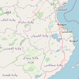
Map view of Chambi National Park

Use this park location map to pinpoint Chambi National Park in Tunisia, understand its exact geographic position, and read its mapped placement within the surrounding landscape more clearly.

Pigeon | © OpenStreetMap contributors

Location context for Chambi National Park

Kasserine Governorate

Explore the landscapes, rocky terrain, and protected habitats of Tunisia's highest peak

Chambi National Park Photos and Mountain Scenery Visual Guide

Visual documentation of Chambi National Park reveals the rugged mountain terrain, forested slopes, and semi-arid valleys defining the protected area. Examining these landscape views and habitat photographs helps researchers understand the environmental character surrounding Mount Chambi more clearly.

Djebel Chambi mountain visible in the distance with arid landscape and scattered vegetation in the foreground under a clear blue sky

Park atlas

Compare regional mountain terrain and connected conservation areas across the wider territory.

Explore Other Parks Near Chambi National Park and Protected Landscapes

Browse nearby national parks and protected areas sharing similar semi-arid mountain ecosystems. Comparing surrounding regional geography provides deeper context for conservation landscapes beyond Mount Chambi.
National parkTunisia
Mapped park locations coincide#1 closest

Chambi National Park: Mapping Tunisia's Premier Mountain Protected Area and Alpine Terrain

Regional alpine geography and protected highland ecosystems

Explore the distinct mountainous geography of Chambi National Park, situated in the Kasserine Governorate of Tunisia. This protected area encompasses the nation's highest peak and serves as a vital refuge for endemic mountain species. The landscape features a complex interaction between Aleppo pine forests, holm oak woodlands, and high-altitude steppe plateaus that define this significant Mediterranean mountain region.

Area
67.23 km²
Established
1980
IUCN
II
Relief
Mountain
National parkTunisia
About 117 km away#2 closest

Northeast

Jebel Serj National Park: Central Tunisia's Distinctive Mountain Protected Area

Explore its terrain and protected landscape context.

Jebel Serj National Park, established in 2010, safeguards a significant mountainous territory in central Tunisia, distinguishing itself from the broader semi-arid plains. This protected landscape showcases the Djebel Serj massif, a unique topographical feature that serves as an ecological bridge between Tunisia's northern and southern regions. Users exploring this page can gain an atlas-level understanding of the park's mapped boundaries, its geological character, and its contribution to the conservation of representative natural diversity within North Africa's transitional ecosystems.

Area
17.2 km²
Established
2010
IUCN
II
Scope
Terrestrial
National parkGafsa Governorate
About 122 km away#3 closest

Southeast

Bou-Hedma National Park: Mapped Protected Area and Conservation Sanctuary in Gafsa Governorate

Discover Saharan wildlife, Roman ruins, and unique semi-arid landscapes.

Bou-Hedma National Park serves as a crucial conservation hub in Tunisia's Gafsa Governorate, renowned for its success in reintroducing endangered Saharan large mammals like the scimitar oryx and addax. The park's geography spans arid plains and seasonal wadis, encompassing the Ramsar-listed Sebkhet Noual wetland. Its unique landscape also preserves significant Roman-era archaeological sites, offering a rich context for exploring protected-area identity, conservation achievements, and ancient human history within a North African setting.

Established
1980
IUCN
II
Access
Access unknown
Scope
Terrestrial
National parkEl Tarf Province
About 158 km away#4 closest

North

El Kala National Park: Protected Wetlands and Barbary Stag Habitat

Explore its mapped geography and vital ecosystem context.

El Kala National Park represents a crucial protected landscape within El Tarf Province, Algeria, recognized internationally for its extensive Mediterranean wetlands and rich biodiversity. This national park is a vital ecological zone, comprising six major lakes and a significant stretch of coastline, offering a unique mosaic of aquatic and terrestrial environments. Its role as a sanctuary for the Barbary stag and migratory birds highlights its importance in regional conservation efforts. Exploring El Kala National Park provides insight into the mapped terrain, protected boundaries, and distinct geographic features that define this significant North African natural area.

Area
764 km²
Established
1993
IUCN
II
Visitors
30K annual
National parkJendouba Governorate
About 176 km away#5 closest

North

El Feidja National Park: National Park Mapping and Protected Landscape Discovery

Explore geographic context within Jendouba Governorate.

Gain a clear understanding of El Feidja National Park's protected status and its geographic footprint. This page offers detailed insights into the park's mapped boundaries and landscape characteristics, situated within the Jendouba Governorate. It serves as a primary resource for atlas exploration, highlighting the natural terrain and regional significance of this Tunisian national park.

Area
27.65 km²
Established
1990
IUCN
II
Relief
Mountain
National parkTunisia
About 189 km away#6 closest

North

Oued Zeen National Park: Tunisia's National Park Entry for Geographic and Landscape Atlas Exploration

Explore the mapped protected area and regional geography of Oued Zeen National Park.

Oued Zeen National Park is a designated national park in Tunisia, offering a crucial point for geographic exploration within the country's atlas. This page details its protected landscape identity, contributing to a structured understanding of regional natural areas and park boundaries. Users can examine its geographic setting and landscape context to deepen their appreciation of Tunisia's protected lands.

Area
67 km²
Established
2010
Scope
Terrestrial
Water
Major water bodies
National parkBizerte Governorate
About 215 km away#7 closest

North

Jebel Chitana-Cap Négro National Park: National Park Protected Area & Landscape Identity

Explore the mapped geography of Jebel Chitana-Cap Négro National Park.

As a designated national park, Jebel Chitana-Cap Négro National Park represents a key protected area for understanding the regional geography of Bizerte Governorate. This entry provides structured information focused on the park's geographic scope, its mapped boundaries, and its significance as a protected landscape. It is designed for users seeking detailed, atlas-style context on Jebel Chitana-Cap Négro National Park's natural setting and its place within Tunisia's protected lands network.

Area
101.2 km²
Established
2010
Relief
Mountain
Scope
Terrestrial
National parkTunisia
About 230 km away#8 closest

Northeast

Ichkeul National Park: Tunisia's Key Protected Landscape for Geographic Discovery

Explore the mapped geography and regional context of this Tunisian national park.

Ichkeul National Park is a crucial protected area located in Tunisia, offering a distinct focal point for geographic exploration and atlas-based understanding. This park's mapped boundaries and protected status are central to appreciating its role within Tunisia's natural landscapes and the wider North African region. Through structured data and detailed geographic context, users can gain insight into Ichkeul National Park's unique environmental identity and its significance as a protected natural resource.

Common questions about visiting, size, designation, and location context for Chambi National Park

Chambi National Park FAQs for park facts, access, geography, and protected area context

Find quick answers about Chambi National Park, including protected-area facts, park geography, trail and visitor context, and how the park fits into its surrounding country and regional landscape.
MoriAtlas Explorer

Continue Your Protected Areas Search Across the Global Atlas

Deepen your exploration by continuing the structured search for national parks and protected areas worldwide. Utilize the comprehensive filtering capabilities to compare different conservation landscapes and refine your understanding of global park geography. Discover more about the distribution and characteristics of protected natural areas.

Global natural geography