

Mori Atlas logo
National parkChambi National Park

Tracing the mapped boundaries and natural terrain of this essential UNESCO-recognized mountain environment in west-central Tunisia.

Chambi National Park: A Comprehensive Geographic Profile of Tunisia's Highest Alpine Protected Mountain Range

Chambi National Park serves as the premier alpine sanctuary in Tunisia, anchored by the dominant peak of Djebel Chambi. This protected area preserves critical Mediterranean mountain ecosystems, ranging from rocky ridgelines and steep forested slopes to expansive semi-arid plateaus. By examining the park boundaries and regional topography, researchers and geography enthusiasts can better understand the environmental significance of this critical North African highland landscape.

Mountain ParksEndangered Species RefugesUNESCO Biosphere ReservesNorth African NatureAlpine EnvironmentsMediterranean Forests

Chambi National Park

National park

Park overview

Structured park overview, official facts, and landscape profile for Chambi National Park

Chambi National Park park facts, protected area profile, and essential visitor context

Review the core facts for Chambi National Park, including designation, size, terrain, visitor scale, habitats, and operating context in one park-focused overview.

About Chambi National Park

Chambi National Park occupies a distinctive position in Tunisia's protected area network as the country's sole significant alpine protected area. The park's mountainous character, centered on Djebel Chambi, provides elevational diversity that supports multiple habitat types rarely found together in Tunisia. The Mont de Tebessa forest massif, of which the park forms a part, represents one of the most extensive forest areas in Tunisia's interior, providing connectivity between Tunisian and Algerian ecosystems. The park's establishment in 1980 followed nearly a decade of focused conservation attention, beginning with a fenced reserve in 1970 specifically designed to protect Cuvier's gazelle populations. The 1977 designation as a UNESCO biosphere reserve elevated the area's international conservation profile, recognizing its ecological significance beyond national boundaries.

Quick facts and research context for Chambi National Park

Chambi National Park covers 67.23 square kilometers of mountainous terrain in western Tunisia. It protects Mount Chambi, the highest point in Tunisia, within the Mont de Tebessa forest massif that spans the border region between Tunisia and Algeria. The park features holm oak woodlands, Aleppo pine forests, and steppe grasslands across its elevational gradient. Notable wildlife includes the endangered Cuvier's gazelle and vulnerable Barbary sheep, while the avifauna features species such as the Egyptian vulture, Bonelli's eagle, and the Tunisian crossbill. The park has no permanent rivers or streams, relying on seasonal precipitation and limited groundwater sources.

Protection and recognition

Documented terrestrial protection scope and established designation year

Chambi National Park Protection Status and Designation History

Chambi National Park maintains a documented terrestrial protection status established in 1977 for conservation oversight. Official records outline the designation timeline and management scope associated with the protected area.

Protection details

Protection scope
Terrestrial
Designated year
1977
Transboundary protection
No
Park context

Deeper park guide and search-rich context for Chambi National Park

Chambi National Park history, landscape, wildlife, and travel context

Explore Chambi National Park through its history, landscape character, ecosystems, wildlife, conservation priorities, cultural context, and seasonal travel timing in a structured park guide built for atlas discovery and search intent.

Why Chambi National Park stands out

Chambi National Park is primarily known for protecting Tunisia's highest mountain and its surrounding fragile ecosystems. The park preserves one of the last remaining refuges of the endangered Cuvier's gazelle in North Africa, making it particularly significant for anti-extinction conservation efforts for this species. It also hosts the vulnerable Barbary sheep, a distinctive North African ungulate. The park's avifauna is notable, particularly the presence of the Tunisian crossbill, an endemic subspecies with limited global distribution. The combination of alpine positioning, endangered mammal species, and endemic bird populations makes this park a focal point for North African conservation science.

Chambi National Park history and protected-area timeline

The conservation history of Chambi National Park reflects Tunisia's broader movement toward systematic environmental protection beginning in the 1970s. In 1970, authorities established a 300-hectare fenced reserve specifically to protect populations of Cuvier's gazelle, which had been experiencing significant decline across its North African range. This targeted intervention recognized the species' vulnerability and the importance of the Chambi area as a remaining stronghold. In 1977, the park and its surrounding缓冲区 were designated as a UNESCO biosphere reserve, a designation that acknowledged both the ecological importance of the mountain ecosystems and the need for sustainable management approaches. The full national park designation followed in 1980, expanding protection to the full 6,723-hectare area and establishing the framework for ongoing conservation management and scientific monitoring.

Chambi National Park landscape and geographic character

The landscape of Chambi National Park is defined by its mountainous terrain, with Djebel Chambi rising as the dominant geographic feature across the protected area. The mountain reaches 1,544 meters above sea level, making it the highest peak in Tunisia and providing the park with a pronounced elevational range that creates diverse microclimates and habitat conditions. The terrain includes rocky ridgelines, steep slopes transitioning to more gentle plateaus, and valleys that channel seasonal water flow. Vegetation patterns follow the elevational gradient, with holm oak woodlands dominating lower slopes, Aleppo pine forming forest patches at mid-elevations, and steppe vegetation including Stipa tenacissima covering exposed plateaus and higher terrain. The absence of permanent rivers or streams means the landscape relies on precipitation and limited spring sources, giving the terrain a character of Mediterranean mountain semi-aridity.

Chambi National Park ecosystems, habitats, and plant life

The ecological character of Chambi National Park reflects its position at the intersection of Mediterranean and Saharan biomes. The park's elevational range supports distinct vegetation zones, from holm oak woodlands at lower elevations through Aleppo pine forests to xeric steppe communities at higher altitudes. The holm oak (Quercus rotundifolia) represents a Mediterranean climate species reaching its southern and eastern limits in this region, while the Aleppo pine provides forest cover in areas where moisture conditions permit. The understory includes species such as Cotoneaster nummularius, a shrubby plant adapted to the seasonal climate. The park's classification as a UNESCO biosphere reserve recognizes these ecological communities as representative of Mediterranean mountain ecosystems that have limited representation in protected area networks across North Africa.

Chambi National Park wildlife and species highlights

Chambi National Park supports several mammal species of significant conservation concern. The Cuvier's gazelle, classified as endangered, finds one of its last remaining refuges within the park boundaries, making this protected area critically important for the species' survival in the wild. The Barbary sheep, also known as aoudad, is present in vulnerable populations, representing a North African endemic that inhabits the mountainous rocky terrain. The park's avifauna is diverse, with notable species including the Egyptian vulture, a scavenging raptor of conservation concern across its range, Bonelli's eagle, and the peregrine falcon. The Tunisian crossbill, an endemic subspecies, represents a particularly significant avian population, as its distribution is limited to this specific region of North Africa.

Chambi National Park conservation status and protection priorities

Chambi National Park holds significant conservation importance at both national and international levels. Its designation as a UNESCO biosphere reserve in 1977 acknowledged the area's ecological significance and the need for coordinated conservation approaches that balance human use with environmental protection. The park serves as a critical refuge for Cuvier's gazelle, an endangered species whose populations have declined dramatically across its North African range, making the protected habitat at Chambi essential for species persistence. The presence of the vulnerable Barbary sheep and the endemic Tunisian crossbill further elevates the park's conservation value, as these populations depend on the specific habitat conditions that the mountain ecosystems provide. The park's position within the Mont de Tebessa forest massif also provides ecological connectivity with Algerian protected areas, supporting broader regional conservation objectives.

Top sights and standout views in Chambi National Park

Chambi National Park offers visitors access to Tunisia's premier mountain hiking environment, with trails ascending toward the summit of Djebel Chambi, the country's highest point. The park's significance extends beyond recreation to include scientific value, as the UNESCO biosphere reserve designation supports research into Mediterranean mountain ecology and endangered species conservation. Wildlife observation opportunities focus on the Cuvier's gazelle and Barbary sheep, though these species require patience and appropriate timing to observe. The birdlife, particularly birds of prey such as the Egyptian vulture and Bonelli's eagle, provides additional naturalist interest, especially for those familiar with North African avifauna.

Best time to visit Chambi National Park

The optimal visiting period for Chambi National Park spans the spring months from March through May, when temperatures are moderate and vegetation is in active growth, enhancing the landscape's visual appeal. Autumn, particularly October and November, offers similar comfortable conditions and represents a second favorable season for exploration. Summer months can bring high temperatures in the mountain environment, though the higher elevation provides some relief compared to lower-lying Tunisian destinations. Winter may bring cold conditions and occasional precipitation, but also offers the possibility of snow-capped views of the mountain peak, though access may be more limited during this season.

Monthly climate preview

Long term monthly temperature ranges and precipitation metrics for Chambi National Park in Tunisia

Chambi National Park Climate Normals, Average Temperature and Precipitation Profiles

Representative coordinate data reveals measured average temperatures ranging from 6.43 degrees Celsius to 27.62 degrees Celsius alongside steady precipitation patterns across the twelve month cycle. Examining the complete monthly climate record provides deeper insight into long term thermal variations and precipitation distribution across the protected area.
Annual mean16 °C
6 °C28 °C
Jan
Feb
Mar11°
Apr14°
May19°
Jun24°
Jul28°
Aug27°
Sep23°
Oct18°
Nov11°
Dec
Warmest month
July

27.6 °C

Coolest month
January

6.4 °C

Wettest month
March

1.3 mm/day

Driest month
July

0.3 mm/day

Park location guide

Geography guide, regional context, and park location map for Chambi National Park

Chambi National Park park geography, regions, and map view in Tunisia

Understand where Chambi National Park sits in Tunisia through a broader geographic reading of the surrounding landscape, nearby location context, and its mapped position within the national park landscape.

How Chambi National Park fits into Tunisia

Tunisia is a Maghreb country in North Africa with a Mediterranean coastline, bordered by Algeria and Libya. The country features the ancient ruins of Carthage, the Great Mosque of Kairouan, and portions of the Atlas Mountains and Sahara Desert. With a population of approximately 12 million, Tunisia operates as a unitary presidential republic with Arabic as the official language.

Wider geography shaping Chambi National Park in Tunisia

Tunisia occupies 163,610 km² in North Africa, bordering Algeria to the west and southwest, Libya to the southeast, and the Mediterranean Sea to the north and east. The country features the eastern end of the Atlas Mountains in the north and extends into the northern Sahara Desert in the south. Its 1,300 km of coastline runs along the Mediterranean Basin. Africa's northernmost point, Cape Angela, is located in Tunisia.

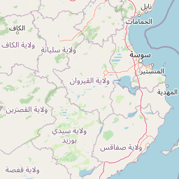
Map view of Chambi National Park

Use this park location map to pinpoint Chambi National Park in Tunisia, understand its exact geographic position, and read its mapped placement within the surrounding landscape more clearly.

Pigeon | © OpenStreetMap contributors

Location context for Chambi National Park

Kasserine Governorate
Park atlas

Compare surrounding mountain landscapes and regional conservation areas

Parks Near Chambi National Park and Related Protected Areas in the Region

Browsing other protected areas near Chambi National Park reveals broader ecological patterns across the interior highland terrain. Comparing these adjacent mountain habitats provides valuable regional context for Mediterranean conservation zones.
National parkKasserine Governorate
Mapped park locations coincide#1 closest

Chambi National Park: Mountain Geography and Protected Landscape Analysis

High elevation terrain in the Kasserine Governorate

Chambi National Park encompasses 67 square kilometers of rugged, high-altitude terrain in Tunisia. This resource maps the park's mountain ecosystem, from its forested valleys to its exposed rocky peaks, providing a structured overview of this significant protected landscape near the Algerian border.

Area
67.23 km²
Established
1980
IUCN
II
Relief
Mountain
National parkTunisia
About 117 km away#2 closest

Northeast

Jebel Serj National Park: Central Tunisia's Distinctive Mountain Protected Area

Explore its terrain and protected landscape context.

Jebel Serj National Park, established in 2010, safeguards a significant mountainous territory in central Tunisia, distinguishing itself from the broader semi-arid plains. This protected landscape showcases the Djebel Serj massif, a unique topographical feature that serves as an ecological bridge between Tunisia's northern and southern regions. Users exploring this page can gain an atlas-level understanding of the park's mapped boundaries, its geological character, and its contribution to the conservation of representative natural diversity within North Africa's transitional ecosystems.

Area
17.2 km²
Established
2010
IUCN
II
Scope
Terrestrial
National parkGafsa Governorate
About 122 km away#3 closest

Southeast

Bou-Hedma National Park: Mapped Protected Area and Conservation Sanctuary in Gafsa Governorate

Discover Saharan wildlife, Roman ruins, and unique semi-arid landscapes.

Bou-Hedma National Park serves as a crucial conservation hub in Tunisia's Gafsa Governorate, renowned for its success in reintroducing endangered Saharan large mammals like the scimitar oryx and addax. The park's geography spans arid plains and seasonal wadis, encompassing the Ramsar-listed Sebkhet Noual wetland. Its unique landscape also preserves significant Roman-era archaeological sites, offering a rich context for exploring protected-area identity, conservation achievements, and ancient human history within a North African setting.

Established
1980
IUCN
II
Access
Access unknown
Scope
Terrestrial
National parkEl Tarf Province
About 158 km away#4 closest

North

El Kala National Park: Protected Wetlands and Barbary Stag Habitat

Explore its mapped geography and vital ecosystem context.

El Kala National Park represents a crucial protected landscape within El Tarf Province, Algeria, recognized internationally for its extensive Mediterranean wetlands and rich biodiversity. This national park is a vital ecological zone, comprising six major lakes and a significant stretch of coastline, offering a unique mosaic of aquatic and terrestrial environments. Its role as a sanctuary for the Barbary stag and migratory birds highlights its importance in regional conservation efforts. Exploring El Kala National Park provides insight into the mapped terrain, protected boundaries, and distinct geographic features that define this significant North African natural area.

Area
764 km²
Established
1993
IUCN
II
Visitors
30K annual
National parkJendouba Governorate
About 176 km away#5 closest

North

El Feidja National Park: National Park Mapping and Protected Landscape Discovery

Explore geographic context within Jendouba Governorate.

Gain a clear understanding of El Feidja National Park's protected status and its geographic footprint. This page offers detailed insights into the park's mapped boundaries and landscape characteristics, situated within the Jendouba Governorate. It serves as a primary resource for atlas exploration, highlighting the natural terrain and regional significance of this Tunisian national park.

Area
27.65 km²
Established
1990
IUCN
II
Relief
Mountain
National parkTunisia
About 189 km away#6 closest

North

Oued Zeen National Park: Tunisia's National Park Entry for Geographic and Landscape Atlas Exploration

Explore the mapped protected area and regional geography of Oued Zeen National Park.

Oued Zeen National Park is a designated national park in Tunisia, offering a crucial point for geographic exploration within the country's atlas. This page details its protected landscape identity, contributing to a structured understanding of regional natural areas and park boundaries. Users can examine its geographic setting and landscape context to deepen their appreciation of Tunisia's protected lands.

Area
67 km²
Established
2010
Scope
Terrestrial
Water
Major water bodies
National parkBizerte Governorate
About 215 km away#7 closest

North

Jebel Chitana-Cap Négro National Park: National Park Protected Area & Landscape Identity

Explore the mapped geography of Jebel Chitana-Cap Négro National Park.

As a designated national park, Jebel Chitana-Cap Négro National Park represents a key protected area for understanding the regional geography of Bizerte Governorate. This entry provides structured information focused on the park's geographic scope, its mapped boundaries, and its significance as a protected landscape. It is designed for users seeking detailed, atlas-style context on Jebel Chitana-Cap Négro National Park's natural setting and its place within Tunisia's protected lands network.

Area
101.2 km²
Established
2010
Relief
Mountain
Scope
Terrestrial
National parkTunisia
About 230 km away#8 closest

Northeast

Ichkeul National Park: Tunisia's Key Protected Landscape for Geographic Discovery

Explore the mapped geography and regional context of this Tunisian national park.

Ichkeul National Park is a crucial protected area located in Tunisia, offering a distinct focal point for geographic exploration and atlas-based understanding. This park's mapped boundaries and protected status are central to appreciating its role within Tunisia's natural landscapes and the wider North African region. Through structured data and detailed geographic context, users can gain insight into Ichkeul National Park's unique environmental identity and its significance as a protected natural resource.

Common questions about visiting, size, designation, and location context for Chambi National Park

Chambi National Park FAQs for park facts, access, geography, and protected area context

Find quick answers about Chambi National Park, including protected-area facts, park geography, trail and visitor context, and how the park fits into its surrounding country and regional landscape.
MoriAtlas Explorer

Continue Your Protected Areas Search Across the Global Atlas

Deepen your exploration by continuing the structured search for national parks and protected areas worldwide. Utilize the comprehensive filtering capabilities to compare different conservation landscapes and refine your understanding of global park geography. Discover more about the distribution and characteristics of protected natural areas.

Global natural geography