

Mori Atlas logo
National parkGalways Land National Park

Discover the mapped terrain and protected area context of Galways Land National Park in Central Province.

Galways Land National Park: Sri Lanka's Protected Landscape and Geographic Atlas Entry

Galways Land National Park stands as a significant protected area within Sri Lanka's Central Province, representing a key entry in the national park atlas. This page provides detailed geographic information, focusing on the park's mapped boundaries, natural terrain, and its role as a conservation landscape. Understand the specific context of Galways Land National Park within its regional setting and explore its protected area identity through a lens of structured geographic discovery.

montane forestbirdwatchingCentral Province Sri Lankaendemic birdsmigratory birdshighland ecosystem

Galways Land National Park

National park

Park overview

Structured park overview, official facts, and landscape profile for Galways Land National Park

Galways Land National Park park facts, protected area profile, and essential visitor context
Review the core facts for Galways Land National Park, including designation, size, terrain, visitor scale, habitats, and operating context in one park-focused overview.

About Galways Land National Park

Galways Land National Park occupies a distinctive position among Sri Lanka's protected areas as one of the smallest national parks in the country, yet one of the most ecologically significant for highland biodiversity. Located within the municipal boundary of Nuwara Eliya, a city in the Central Province known for its tea plantations and cool climate, the park protects a remnant of the montane forest that once covered this highland region. The transition from sanctuary status in 1938 to full national park designation in 2006 reflects evolving conservation priorities in Sri Lanka, where montane ecosystems face pressure from agricultural expansion and urban development. The Department of Wildlife Conservation manages the park as part of a network that includes several other protected areas in the central highlands, an area recognized for its ecological importance and endemism.

Quick facts and research context for Galways Land National Park

Galways Land National Park covers 27 hectares (0.10 square miles) of montane forest in the Central Province of Sri Lanka, within the Nuwara Eliya municipal area. The park was originally declared a wildlife sanctuary in May 1938 and received national park designation in May 2006. It is managed by the Department of Wildlife Conservation and classified under IUCN Category II. The park is notable for its dense montane forest character and its concentration of birdlife, hosting approximately 30 native bird species and around 20 rare migratory species.

Park context

Deeper park guide and search-rich context for Galways Land National Park

Galways Land National Park history, landscape, wildlife, and travel context
Explore Galways Land National Park through its history, landscape character, ecosystems, wildlife, conservation priorities, cultural context, and seasonal travel timing in a structured park guide built for atlas discovery and search intent.

Why Galways Land National Park stands out

Galways Land National Park is best known as one of Sri Lanka's premier birdwatching destinations. The park's montane forest habitat at elevation supports an exceptional concentration of avifauna, including both resident endemic species and seasonal migrants. Notable species include the Ceylon white-eye, Kashmir flycatcher, and mountain leaf warbler. The Field Ornithology Group of Sri Lanka identifies this park alongside Victoria Park as the two most significant birdwatching sites in the country. Beyond birds, the park preserves valuable flora of both native and introduced origin within its compact montane forest setting.

Galways Land National Park history and protected-area timeline

The area that now comprises Galways Land National Park was first protected as a wildlife sanctuary on 27 May 1938, establishing nearly seven decades of continuous conservation status before its elevation to national park status. On 18 May 2006, the sanctuary was redesignated as a national park, a change that reflected both the ecological significance of the montane forest and the need for enhanced protection mechanisms. This progression from sanctuary to national park mirrors a broader pattern in Sri Lankan conservation history, where early wildlife protection areas were gradually upgraded as conservation science and national environmental policy matured. The 2006 designation coincided with increased attention to Sri Lanka's montane ecosystems, which contain species found nowhere else on Earth.

Galways Land National Park landscape and geographic character

The park sits in the central highlands of Sri Lanka at elevations characteristic of montane terrain, with the landscape dominated by dense forest cover adapted to the cooler, cloudier conditions of highland environments. The terrain around Nuwara Eliya is inherently mountainous, with rolling slopes and valley systems that create diverse microhabitats within the forest. While the park itself is compact at 27 hectares, its position within the highlands places it in a landscape of significant topographic variation. The forest within the park is described as dense, indicating canopy closure and layered vegetation structure typical of montane forest ecosystems.

Galways Land National Park ecosystems, habitats, and plant life

The montane forest ecosystem of Galways Land National Park represents a distinctive ecological zone in Sri Lanka, characterized by vegetation adapted to higher elevations, cooler temperatures, and higher moisture levels. The park preserves valuable flora, both native species and introduced specimens, within its boundaries. This combination of native and introduced plant material creates a complex vegetation structure that supports diverse ecological interactions. Montane forests in Sri Lanka are globally significant for their endemic biodiversity, and even small remnants like Galways Land contribute to the preservation of these communities.

Galways Land National Park wildlife and species highlights

Galways Land National Park is distinguished by its exceptional avifauna, with the Field Ornithology Group of Sri Lanka recognizing it as one of the country's most important birdwatching sites. The park supports approximately 30 native bird species alongside about 20 rare migrant species that visit during seasonal movements. Endemic species found in the park include the Ceylon white-eye, Kashmir flycatcher, and mountain leaf warbler, each representing species adapted to highland forest habitats. The park's significance for migratory birds indicates its role as a waypoint or wintering ground in regional flyway patterns, adding to its ecological importance beyond resident species.

Galways Land National Park conservation status and protection priorities

The designation of Galways Land as a national park reflects its conservation significance within Sri Lanka's protected area network. The park was established specifically to conserve the unique montane ecosystems of the central highlands, an environment that supports species found nowhere else on Earth. As one of the smallest national parks in Sri Lanka, it demonstrates that even limited areas can hold substantial ecological value when they protect critical habitat types. The park's location within the Nuwara Eliya municipal area also highlights the challenge of maintaining natural ecosystems in proximity to urban development, making its continued protection particularly important for highland biodiversity.

Galways Land National Park cultural meaning and human context

Galways Land National Park is located in an area of Sri Lanka with strong colonial-era associations, as Nuwara Eliya was developed as a hill station during British rule and remains known for its tea industry and temperate climate. The park sits in proximity to the Galway Forest Lodge, suggesting historical human presence in the general area. The highland region has long been valued for its agricultural potential, particularly tea cultivation, which has shaped the landscape surrounding the park. While the park itself does not contain documented indigenous heritage sites, the broader central highlands region contains cultural landscape elements reflecting centuries of human interaction with the terrain.

Top sights and standout views in Galways Land National Park

The park's compact size makes it an accessible destination for visitors interested in Sri Lankan highland nature, with dense montane forest and exceptional birdwatching opportunities within a manageable area. The concentration of approximately 50 bird species, including both residents and migrants, represents remarkable biodiversity for a 27-hectare site. Its designation as one of the two most significant birdwatching sites in Sri Lanka by the Field Ornithology Group establishes its reputation among ornithological communities. The proximity to Victoria Park in Nuwara Eliya creates an opportunity for combined visits exploring different aspects of the region's avifauna.

Best time to visit Galways Land National Park

The best time to observe birds in Galways Land National Park coincides with the migratory season, when the park's populations of rare migrant birds are present. Sri Lanka's highland climate varies with monsoon seasons, with the northeast monsoon (December to March) bringing most rainfall to the central highlands. The periods surrounding monsoon seasons often provide favorable conditions for birdwatching, though the park can be visited year-round given its accessible location within Nuwara Eliya. The montane forest environment maintains its character throughout the year, though visitors should anticipate cool highland conditions regardless of season.
Park location guide

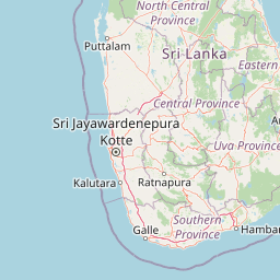
Geography guide, regional context, and park location map for Galways Land National Park

Galways Land National Park park geography, regions, and map view in Sri Lanka
Understand where Galways Land National Park sits in Sri Lanka through a broader geographic reading of the surrounding landscape, nearby location context, and its mapped position within the national park landscape.

How Galways Land National Park fits into Sri Lanka

Sri Lanka is a tropical island nation in South Asia with a recorded history spanning over 3,000 years. Formerly known as Ceylon, it became independent in 1948 and adopted its current constitutional name in 1972. The country features diverse geography ranging from coastal plains to mountainous highlands and maintains a population exceeding 22 million.

Wider geography shaping Galways Land National Park in Sri Lanka

Sri Lanka is an island nation in the Indian Ocean, positioned southwest of the Bay of Bengal. It is separated from India by the Gulf of Mannar and Palk Strait to the northwest. The island has a pear-like shape with diverse terrain including coastal plains, central highlands, and river valleys.

Map view of Galways Land National Park

Use this park location map to pinpoint Galways Land National Park in Sri Lanka, understand its exact geographic position, and read its mapped placement within the surrounding landscape more clearly.

Pigeon | © OpenStreetMap contributors

Location context for Galways Land National Park

Central Province
Park atlas

Trace the regional spread of protected areas and compare park geography in Sri Lanka's central highlands.

Discover Other National Parks and Protected Areas Near Galways Land National Park
Extend your exploration beyond Galways Land National Park by browsing other national parks and protected areas in Sri Lanka's Central Province, focusing on its unique montane forest and highland ecosystems. Comparing these regional park geographies provides deeper insight into conservation landscapes and their distinct environmental characteristics.
National parkCentral Province

Horton Plains National Park: A Protected Landscape within Sri Lanka's Central Province

Explore its mapped geographic boundaries and park identity.

Delve into the geographic specifics of Horton Plains National Park, a designated national park located in the Central Province of Sri Lanka. This entry provides detailed insights into its protected area status, mapped landscape features, and regional geographic context. Understand how this park contributes to the atlas of protected lands and offers a distinct point for landscape exploration.

Area
31.6 km²
Established
1988
IUCN
II
Relief
Mountain
National parkSri Lanka

Udawalawe National Park: National Park Protected Landscape and Geographic Atlas

Explore Sri Lanka's mapped natural terrain and park boundaries.

Gain a comprehensive atlas-level understanding of Udawalawe National Park, a key protected landscape in Sri Lanka. This entry focuses on the park's distinct geographic identity, its mapped boundaries, and its significance as a protected area within the island's diverse natural terrain. Explore how this national park contributes to the regional geography and provides structured insights for landscape discovery.

Area
308.21 km²
Established
1972
IUCN
II
Visitors
188.4K annual
National parkUva Province

Gal Oya National Park: Protected Landscape and Reservoir Geography in Uva Province

Explore savannah grasslands, elephant populations, and mapped terrain.

Gal Oya National Park presents a unique protected landscape within Uva Province, Sri Lanka. This national park is defined by its broad savannah grasslands, known as thalawa, interspersed with forested hills and the vast Senanayake Samudraya reservoir. Its varied topography, from lowlands to mountain peaks, offers a rich canvas for geographic exploration and understanding protected-area dynamics. The park's consistent visibility of elephant populations across these diverse terrains makes it a key site for wildlife observation within Sri Lanka's atlas of natural heritage.

Area
259 km²
Established
1954
IUCN
II
Relief
Mountain
National parkWestern Province

Horagolla National Park: Sri Lanka's Mapped Protected National Park in Western Province

Explore geographic boundaries and protected landscape context.

Horagolla National Park represents a significant protected natural area within Sri Lanka's Western Province. This detail page offers users the opportunity to examine the park's specific geographic setting, its mapped protected boundaries, and its overall context within the island's atlas of natural landscapes. Gain a structured understanding of this national park entity and its regional geographic features.

Area
0.33 km²
Established
1973
IUCN
II
Relief
Lowland
National parkSri Lanka

Lunugamvehera National Park: Sri Lanka's Protected Area Mapping and Geographic Identity

Mapped terrain and national park boundaries in Sri Lanka.

Lunugamvehera National Park is a dedicated national park situated in Sri Lanka. This entry facilitates a focused exploration of its protected landscape, offering insight into its mapped geography and position within the country's conservation network. Understand the park's role and its physical characteristics through detailed geographic and atlas-oriented information.

Area
234.988 km²
Established
1995
IUCN
II
Relief
Lowland
National parkCentral Province

Wasgamuwa National Park: A National Park in Central Province for Geographic Exploration

Mapped protected boundaries and landscape context.

Wasgamuwa National Park is a significant national park located in Sri Lanka's Central Province, offering valuable data for atlas exploration and geographic understanding. This protected area's mapped boundaries and regional setting within Central Province provide essential context for researchers and explorers focused on conservation landscapes. Discover the park's unique geographic identity and its contribution to the regional atlas, highlighting its role as a structured natural landscape.

Area
393.22 km²
Established
1984
IUCN
II
Relief
Upland
National parkEastern Province

Lahugala Kitulana National Park: Eastern Province National Park Protected Landscape Discovery

Explore mapped boundaries and regional geography.

Lahugala Kitulana National Park is a key protected area, designated as a national park within Sri Lanka's Eastern Province. This content focuses on its geographic identity, including mapped park boundaries and its regional landscape context. Gain a structured understanding of this protected natural land for atlas-based exploration, highlighting its geographical significance and protected status.

Area
15.54 km²
Established
1980
IUCN
II
Relief
Lowland
Watercolor illustration of a landscape with green hills, grassy foreground, and pink sky
National parkSri Lanka

Ussangoda National Park: Sri Lanka's National Park and Protected Landscape Atlas Entry

Mapped protected boundaries and regional geographic context.

Ussangoda National Park represents a vital component of Sri Lanka's protected natural areas, offering unique insights into its landscape and geography. This atlas entry focuses on the park's identity as a national park, providing a detailed view of its mapped boundaries and its specific location within the island's diverse geography. Understand the protected land context and the unique characteristics that define Ussangoda National Park for focused geographic discovery.

Area
3.49 km²
Established
2010
IUCN
II
Relief
Upland

Common questions about visiting, size, designation, and location context for Galways Land National Park

Galways Land National Park FAQs for park facts, access, geography, and protected area context
Find quick answers about Galways Land National Park, including protected-area facts, park geography, trail and visitor context, and how the park fits into its surrounding country and regional landscape.
MoriAtlas Explorer

Continue Your Protected Areas Search Across the Global Atlas

Deepen your exploration by continuing the structured search for national parks and protected areas worldwide. Utilize the comprehensive filtering capabilities to compare different conservation landscapes and refine your understanding of global park geography. Discover more about the distribution and characteristics of protected natural areas.

Global natural geography