Mori Atlas logo
National parkGangotri National Park

Discover the mapped boundaries and landscape context of this protected area in Uttarakhand.

Gangotri National Park: Uttarakhand Protected Area and National Park Geography Atlas

Gangotri National Park represents a significant protected landscape within the Garhwal region of Uttarakhand, India. As a designated national park, its geographic scope and mapped boundaries offer critical insights into the region's natural terrain. This park is essential for understanding the distribution of protected areas across the Himalayan state, providing a focused lens for atlas-driven exploration of India's conservation landscapes.

National ParkHimalayan Protected AreaGlacial LandscapeSacred GeographyAlpine EcosystemsWildlife Habitat

Gangotri National Park

National park

Park overview

Structured park overview, official facts, and landscape profile for Gangotri National Park

Gangotri National Park park facts, protected area profile, and essential visitor context
Review the core facts for Gangotri National Park, including designation, size, terrain, visitor scale, habitats, and operating context in one park-focused overview.

About Gangotri National Park

Gangotri National Park occupies a remarkable position in the western Himalayan region, protecting a vast swath of mountainous terrain in Uttarkashi District of Uttarakhand state. The park's name derives from the sacred town of Gangotri, which marks the access point to one of Hinduism's most revered pilgrimage sites. Within the park's boundaries lies the Gaumukh glacier, emerging from the larger Gangotri glacier system, which has been traditionally identified as the origin of the Ganges River. This religious and geographical significance has drawn visitors to the region for centuries, though the park's formal protection dates only to 1989. The park spans an area of approximately 2,390 square kilometers, though some sources cite the core protected area as 1,553 square kilometers. Its northern and northeastern boundaries follow the international border with China, situating the park at a transition point between Indian and Tibetan biogeographical realms. The landscape is characterized by extraordinary topographical diversity, with high mountain ridges, deep river gorges, rocky craggy glaciers, and narrow valley systems creating a complex three-dimensional terrain. Elevation gradients from 1,800 to 7,083 meters produce dramatic ecological zonation, supporting communities ranging from subalpine coniferous forests at lower elevations to alpine meadows and permanent snow cover at higher altitudes.

Quick facts and research context for Gangotri National Park

Gangotri National Park covers roughly 2,390 square kilometers in the upper Bhagirathi river catchment of Uttarakhand, India. The park was established in 1989 and falls under IUCN Category II protection. Its elevation range spans from 1,800 to over 7,000 meters, supporting diverse biomes from subtropical communities to alpine meadows. The park is managed by the Forest Department of the Government of Uttarakhand and forms a contiguous conservation landscape with Govind National Park and Kedarnath Wildlife Sanctuary.

Park context

Deeper park guide and search-rich context for Gangotri National Park

Gangotri National Park history, landscape, wildlife, and travel context
Explore Gangotri National Park through its history, landscape character, ecosystems, wildlife, conservation priorities, cultural context, and seasonal travel timing in a structured park guide built for atlas discovery and search intent.

Why Gangotri National Park stands out

Gangotri National Park is best known for housing the Gaumukh glacier, the terminus of the Gangotri glacier and the traditional source point of the Ganges, one of the most sacred rivers in Hinduism. The park's extreme elevation range and position in the Trans-Himalayan zone support remarkable biodiversity including the elusive snow leopard, blue sheep, Himalayan tahr, and musk deer. Its dramatic landscape features high ridges, deep gorges, precipitous cliffs, and glacial valleys that create a visually spectacular mountain environment. The combination of religious significance as a Hindu pilgrimage destination and outstanding ecological value makes this park uniquely distinguished within India's national park system.

Gangotri National Park history and protected-area timeline

Gangotri National Park was established in 1989 as part of India's expanding network of protected areas designed to conserve the nation's mountainous ecosystems and biodiversity. The creation of the park reflected growing recognition of the ecological importance of the upper Himalayan catchments, particularly as these regions face pressures from climate change, infrastructure development, and increasing pilgrimage-related tourism. The park was designated under IUCN Category II, reflecting its primary mandate of protecting natural ecosystems while allowing for limited sustainable use. Prior to formal protection, the Gangotri region had long been recognized for its religious significance, with the Gangotri temple serving as one of the Char Dhams (four sacred sites) of the Hindu pilgrimage circuit. The establishment of the park created a management framework that balances ecological conservation with the traditional religious uses of the landscape, though tensions between these objectives continue to present challenges. The park now forms part of a larger contiguous conservation landscape in Uttarakhand, connecting with Govind National Park to the southeast and Kedarnath Wildlife Sanctuary to the east, creating a vital wildlife corridor through the central Himalayan region.

Gangotri National Park landscape and geographic character

The landscape of Gangotri National Park presents an imposing spectacle of Himalayan mountain terrain, characterized by dramatic topographical variation across its vast expanse. High ridges rise sharply from valley floors, their crests often remaining snow-capped throughout the year. Deep gorges have been carved by the Bhagirathi River and its tributaries over geological time, creating vertical drops that can exceed hundreds of meters. The geology is dominated by Himalayan crystalline formations, with granite and other metamorphic rocks providing the structural foundation for the terrain. Throughout the park, rocky craggy glaciers cling to mountain faces and occupy valley heads, remnants of the Pleistocene glaciations that shaped much of the Himalayan landscape. Between these glacial features, narrow valleys funnel watercourses downward, their floors often filled with glacial outwash deposits and debris. The elevation gradient from 1,800 to 7,083 meters creates a dramatic visual progression, with the lower valleys supporting vegetation and human settlement while the upper reaches remain permanently frozen or covered in seasonal snow. The combination of these features produces a landscape of exceptional visual diversity and geological interest.

Gangotri National Park ecosystems, habitats, and plant life

The ecological character of Gangotri National Park reflects its position in the biogeographical zone designated as 2A West Himalaya, combining elements from both the Himalayan and Trans-Himalayan realms. At lower elevations, the park supports Western Himalayan subalpine conifer forests dominated by species such as chir pine, deodar cedar, fir, and spruce, with interspersed oak woodlands. These forests transition to Western Himalayan alpine shrub and meadows at higher elevations, where rhododendron thickets become increasingly prominent. The vegetation pattern includes kharsu oak communities in patches at mid-elevations and birch formations in higher areas. However, the park's ecology has been significantly affected by landslide activity along the route from Gangotri to Gaumukh, with these events creating isolation between forest patches and affecting the connectivity of alpine vegetation communities. The ground vegetation, while showing signs of drying in some areas, still demonstrates significant biomass with coverage ranging from 10 to 50 percent across different portions of the park. This diverse habitat matrix supports both Himalayan and Trans-Himalayan species assemblages, creating a complex ecological community that reflects the park's transitional position between different biogeographical zones.

Gangotri National Park wildlife and species highlights

Gangotri National Park supports a remarkable assembly of Himalayan wildlife, with fifteen mammal species and over one hundred fifty bird species documented within its boundaries. The park is particularly renowned for populations of the snow leopard, one of the most elusive and endangered big cats in the world, whose presence in these high-altitude landscapes reflects the excellent conservation status of the area. The ungulate community includes blue sheep, also known as bharal, which represents one of the most abundant large mammal species in the park, along with Himalayan tahr and musk deer. Predatory mammals include Asian black bear and brown bear, both of which inhabit the park's forest and alpine zones. The avifauna is particularly diverse, with species including the colorful Himalayan monal, the koklass pheasant, and the Himalayan snowcock representing the park's notable birdlife. Additional species include various pheasants, partridges, doves, and pigeons that occupy the diverse habitat types from forest understory to alpine meadows. The park's position along a major Himalayan migratory corridor also contributes to its ornithological significance, though the full extent of seasonal bird movements through the area remains an ongoing area of study.

Gangotri National Park conservation status and protection priorities

Gangotri National Park represents an important conservation asset in India's protected area network, serving as a protected habitat for species of significant conservation concern including the snow leopard, which is listed as vulnerable on the IUCN Red List. The park's inclusion within a larger contiguous conservation landscape connecting Govind National Park and Kedarnath Wildlife Sanctuary creates essential wildlife corridors that enable species movement through the fragmented Himalayan environment. The park's elevation gradient and diverse habitat types protect representative samples of Western Himalayan ecosystems, including both subalpine coniferous forests and alpine meadows that have been identified as priorities for conservation under India's protected area framework. However, the park faces ongoing conservation challenges including the impacts of climate change on glacier systems, landslide events that fragment habitat connectivity, and the pressures associated with religious pilgrimage tourism to the Gangotri region. The documentation of landslide-induced isolation between forest patches has highlighted the need for ongoing ecological monitoring to understand the long-term conservation implications of these natural disturbance events.

Gangotri National Park cultural meaning and human context

Gangotri National Park occupies a landscape of profound religious significance within Hinduism, as the region surrounding the Gangotri temple is one of the four sacred Char Dhams that constitute the holiest pilgrimage circuit in the tradition. The town of Gangotri, from which the park takes its name, serves as the base for pilgrims seeking to visit the Gaumukh glacier, traditionally considered the source of the Ganges River. This spiritual significance has drawn visitors to the region for centuries, creating a cultural landscape where religious practice and natural environment have become deeply intertwined. The park's establishment in 1989 occurred within this context of ongoing religious use, requiring management approaches that accommodate both conservation objectives and traditional cultural practices. Local communities have historically maintained relationships with the landscape that include seasonal grazing, pilgrimage access, and religious observances, creating a human-environment dynamic that differs from many strictly wilderness-focused protected areas.

Top sights and standout views in Gangotri National Park

Gangotri National Park offers visitors access to one of the most spiritually and ecologically significant landscapes in the Himalayan region. The opportunity to trek to Gaumukh, the glacier source of the Ganges, provides a profound connection to both natural spectacle and religious tradition. The park's wildlife, particularly the chance to encounter snow leopard, blue sheep, and Himalayan tahr in their natural high-altitude habitat, represents a major draw for nature enthusiasts and wildlife photographers. The dramatic mountain scenery, with its towering peaks, glacial valleys, and alpine meadows, creates exceptional trekking and exploration opportunities throughout the park's vast terrain. The combination of religious pilgrimage routes and backcountry wilderness access allows visitors to experience the full spectrum of what this remarkable protected area offers.

Best time to visit Gangotri National Park

The optimal period for visiting Gangotri National Park spans from late spring through early autumn, roughly May through October, when weather conditions allow access to the park's trails and higher-elevation zones. The summer months of June through September typically offer the most stable conditions for trekking, with relatively warm temperatures in the valleys and clear skies revealing the mountain landscape. During these months, the alpine meadows bloom with wildflowers, creating particularly scenic conditions throughout the park. The monsoon season from July to September brings significant rainfall to the region, which can trigger landslides and make some routes hazardous, though it also transforms the landscape with lush vegetation. Winter conditions from November through April bring heavy snowfall that closes most access routes and makes the high-altitude portions of the park inaccessible to most visitors. The pre-monsoon period in May and early June offers pleasant temperatures and relatively clear conditions before the monsoon clouds arrive.

Park location guide

Geography guide, regional context, and park location map for Gangotri National Park

Gangotri National Park park geography, regions, and map view in India
Understand where Gangotri National Park sits in India through a broader geographic reading of the surrounding landscape, nearby location context, and its mapped position within the national park landscape.

How Gangotri National Park fits into India

India is a South Asian country bordered by the Indian Ocean, Arabian Sea, and Bay of Bengal. It shares land borders with Pakistan, China, Nepal, Bhutan, Bangladesh, and Myanmar. The country has a population of over 1.4 billion people and operates as a federal parliamentary republic with its capital in New Delhi.

Wider geography shaping Gangotri National Park in India

India occupies the Indian subcontinent in South Asia, bordered by the Arabian Sea to the southwest, the Bay of Bengal to the southeast, and the Indian Ocean to the south. It shares land borders with Pakistan to the west, China, Nepal, and Bhutan to the north, and Bangladesh and Myanmar to the east. The territory also includes the Andaman and Nicobar Islands in the Indian Ocean.

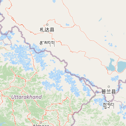
Map view of Gangotri National Park

Use this park location map to pinpoint Gangotri National Park in India, understand its exact geographic position, and read its mapped placement within the surrounding landscape more clearly.

Pigeon | © OpenStreetMap contributors

Location context for Gangotri National Park

UttarakhandUttarkashi District
Park atlas

Browse the protected landscapes and mapped geography of the Western Himalayas, tracing regional park connections.

Explore National Parks and Protected Areas Surrounding Gangotri National Park, Western Himalayas
Continue your exploration beyond Gangotri National Park by browsing other national parks and protected areas across the surrounding Himalayan region of Uttarakhand, India. Compare diverse glacial landscapes, alpine ecosystems, and critical wildlife habitats to understand the broader conservation geography and regional park context.
National parkChamoli district

Valley of Flowers National Park: National Park Protected Landscape and Geographic Context

Explore the mapped terrain and regional boundaries of this Himalayan national park.

Valley of Flowers National Park is a distinct protected area within India's Garhwal region, situated in the Chamoli district. This park detail page facilitates atlas-focused discovery, highlighting its mapped boundaries and geographic significance. Users can explore the protected landscape's role within its regional context, providing essential data for understanding its ecological and geographical importance for landscape exploration.

Area
87.5 km²
Established
1982
Relief
Mountain
Climate
Alpine
National parkUttarakhand

Nanda Devi National Park: High-Altitude Protected Landscape and Himalayan Geography

Explore mapped glacial basins and alpine terrain in Uttarakhand.

Nanda Devi National Park is a prime example of a high-altitude protected area, nestled in the Garhwal Himalayas of Uttarakhand, India. Established in 1982, this national park protects a vast glacial sanctuary, renowned for its dramatic peaks, including Nanda Devi, India's second-highest mountain. The park's landscape is defined by rugged terrain, extensive glaciers like the Uttari Rishi and Dakshini Rishi, and a striking ring of mountains over 6,000 meters, providing critical context for understanding protected land geography and Himalayan atlas exploration.

Area
630.33 km²
Established
1982
IUCN
II
Relief
Mountain
National parkHimachal Pradesh

Pin Valley National Park: Remote Himalayan Cold Desert National Park in Himachal Pradesh

Explore its dramatic terrain and unique protected landscape in Spiti Valley.

Pin Valley National Park is a significant protected area covering roughly 675 square kilometers of the cold desert region in Himachal Pradesh, India. Established as a national park, it showcases a remote and rugged Himalayan landscape, characterized by its stark beauty, sparse vegetation, and extreme temperatures typical of high-altitude deserts. The park's geography spans dramatic mountain terrain, steep cliffs, and deep valleys, forming a vital habitat for endangered species and contributing to the unique ecological profile of the Cold Desert Biosphere Reserve.

Area
675 km²
Established
1987
IUCN
II
Relief
Mountain
National parkHimachal Pradesh

Great Himalayan National Park: Protected Landscape and Mapped Geography

Explore this national park's dramatic elevation and rich biodiversity.

Great Himalayan National Park is a vital protected area within India's Himachal Pradesh, celebrated for its exceptional biodiversity and dramatic mountain geography. This national park encompasses a remarkable range of elevations, creating distinct ecological zones from lower forest elevations to high alpine meadows and glacial zones. Its significance as a mapped protected landscape makes it essential for understanding regional natural heritage and conservation efforts within the Himalayas.

Area
1,171 km²
Established
1984
IUCN
II
Relief
Mountain
National parkUttarakhand

Rajaji National Park: Uttarakhand National Park and Tiger Reserve Landscape

Sivalik Hills geography and protected area context

Rajaji National Park is a vital protected landscape situated in the Uttarakhand region of India, recognized as both a national park and a tiger reserve. Its territory spans across the Sivalik Hills, offering a diverse terrain characterized by deciduous forests and riparian ecosystems. The park's location along the Ganga river significantly influences its ecology, providing a unique geographic context for its protected status and wildlife significance.

Area
820.5 km²
Established
1983
IUCN
II
Relief
Highland
National parkHaryana

Kalesar National Park: Exploring Haryana's Unique Sal Forest Protected Landscape

Discover mapped terrain and regional geography within the Shivalik foothills.

Kalesar National Park, located in the Shivalik foothills of Haryana, is a crucial protected area renowned for its natural sal forest, a rare ecological feature in the state. Spanning approximately 53 square kilometers, the park's diverse terrain offers insights into regional geography and conservation, serving as a vital habitat for leopards and a corridor for wild elephants. Its mapped boundaries encompass a unique landscape that contrasts sharply with surrounding agricultural lands, making it a significant point of study for protected-area enthusiasts.

Area
53 km²
Established
2003
IUCN
IV
Relief
Highland
National parkUttarakhand

Jim Corbett National Park: Uttarakhand National Park and Protected Landscape Atlas

Mapped Boundaries and Regional Geographic Context

Jim Corbett National Park offers a specific entry point for understanding protected landscapes and their geographic significance. As a designated national park within Uttarakhand, India, it provides a distinct case study for exploring mapped boundaries and regional natural terrain. This detailed view allows for a deep dive into the park's identity as a protected area, highlighting its placement within the larger atlas of India's natural heritage and its contribution to the Himalayan geographic narrative.

Area
1,288.31 km²
Established
1936
IUCN
II
Visitors
365K annual
National parkNepal

Khaptad National Park: Nepal's National Park Landscape and Protected Area Geography

Explore the mapped terrain and regional context of this protected landscape.

Khaptad National Park is a designated national park in Nepal, offering a unique entry point for exploring protected landscapes and regional geography. This entry details the park's mapped boundaries and its significance within the broader atlas of natural terrain. Users can delve into the specific geographic context of this protected area, understanding its role within Nepal and the wider South Asian context for structured landscape discovery.

Area
225 km²
Established
1984
IUCN
II
Relief
Mountain

Common questions about visiting, size, designation, and location context for Gangotri National Park

Gangotri National Park FAQs for park facts, access, geography, and protected area context
Find quick answers about Gangotri National Park, including protected-area facts, park geography, trail and visitor context, and how the park fits into its surrounding country and regional landscape.
MoriAtlas Explorer

Continue Your Protected Areas Search Across the Global Atlas

Deepen your exploration by continuing the structured search for national parks and protected areas worldwide. Utilize the comprehensive filtering capabilities to compare different conservation landscapes and refine your understanding of global park geography. Discover more about the distribution and characteristics of protected natural areas.

Global natural geography