Mori Atlas logo
National parkGurez National Park

Discover the mapped boundaries and regional geography of this vital national park.

Gurez National Park: Pakistan's Himalayan Protected Landscape Atlas Entry

Gurez National Park represents a significant protected area within Pakistan's stunning Himalayan mountain range. This dedicated entry provides an atlas-style overview of its geographic scope, focusing on the unique alpine ecosystems, vital musk deer habitats, and the dramatic terrain that defines this remote wilderness. Understand the park's role in conservation and its place within the broader mapped landscape of South Asia, offering factual context for geographic exploration.

Himalayan protected areaMusk deer habitatAlpine ecosystemsKashmir mountainsValley conservationRemote wilderness

Gurez National Park

National park

Park overview

Structured park overview, official facts, and landscape profile for Gurez National Park

Gurez National Park park facts, protected area profile, and essential visitor context

Review the core facts for Gurez National Park, including designation, size, terrain, visitor scale, habitats, and operating context in one park-focused overview.

About Gurez National Park

Gurez National Park occupies the remote Gurez Valley, a strategically significant and ecologically sensitive area in the Himalayan region. The park's creation reflected growing recognition of the need to protect the musk deer species from poaching and habitat loss, as well as preserve the broader alpine ecosystem. The valley has been inhabited for centuries by the Dard people, an indigenous community with distinct cultural traditions tied to the land. The protected area boundaries encompass both the core conservation zone and surrounding landscape that supports local pastoral activities. Management of the park balances conservation objectives with the traditional livelihoods of resident communities who have long co-existed with the wildlife populations. The region's political context has historically affected access and development, contributing to its relative remoteness and limited tourism infrastructure compared to other Himalayan destinations.

Quick facts and research context for Gurez National Park

Gurez National Park is situated in the northern reaches of the Kashmir Valley at elevations ranging from 2,200 to 4,300 meters above sea level. The park was designated primarily to protect habitat for the vulnerable musk deer, a species prized for its musk pod which has historically driven poaching pressures. The landscape features a mix of coniferous forests, alpine meadows, and rocky terrain traversed by the Kishenganga River. The region experiences heavy winter snowfalls that isolate the valley for several months each year.

Park context

Deeper park guide and search-rich context for Gurez National Park

Gurez National Park history, landscape, wildlife, and travel context

Explore Gurez National Park through its history, landscape character, ecosystems, wildlife, conservation priorities, cultural context, and seasonal travel timing in a structured park guide built for atlas discovery and search intent.

Why Gurez National Park stands out

Gurez National Park is best known for its population of musk deer, the endangered ungulate species that inspired its original designation as Musk Deer National Park. The park protects one of the few remaining habitats for this shy and elusive animal in the Himalayas. Beyond musk deer, the valley is renowned for its spectacular mountain scenery, traditional Dard villages, and relative isolation that has preserved both natural and cultural heritage. The Kishenganga River, which flows through the valley, adds to the landscape's dramatic character.

Gurez National Park history and protected-area timeline

The precise establishment date of Gurez National Park as a formal protected area reflects broader conservation development in the Kashmir region during the latter decades of the twentieth century. The park was originally designated with a focus on musk deer protection, responding to serious declines in populations driven by demand for musk in traditional medicine and perfumery. Over time, the conservation framework evolved to encompass broader ecological protection goals. The valley's history extends far beyond its protected area status, with archaeological evidence suggesting human habitation dating back centuries. The Dard-speaking communities of Gurez maintain cultural connections to the land that predate modern conservation frameworks. Political developments affecting the Kashmir region have influenced access to the area and the evolution of management approaches.

Gurez National Park landscape and geographic character

The Gurez Valley landscape is defined by its position within the greater Himalayan mountain system, featuring dramatic elevation changes, steep-sided valleys, and towering peaks that frame the valley floor. The Kishenganga River cuts through the valley, creating riparian corridors and meadows alongside its course. The terrain transitions from forested lower slopes to alpine meadows and eventually to rocky, barren terrain at higher elevations. During winter, heavy snowfall transforms the landscape dramatically, with the valley becoming effectively isolated until spring melt opens passes and routes. The combination of river valleys, mountain ridges, and open meadows creates a diverse visual landscape that characterizes this corner of the Himalayas.

Gurez National Park ecosystems, habitats, and plant life

The natural environment of Gurez National Park reflects the biodiversity patterns typical of the western Himalayan ecosystem. The vegetation follows altitudinal zones, with coniferous forests of pine and spruce giving way to birch and juniper at higher elevations before transitioning to alpine meadows. These habitats support a range of species adapted to the challenging climate and seasonal extremes. The park's conservation focus on musk deer highlights the species' ecological role within this environment, though the park also protects other fauna including various ungulates, small mammals, and bird species. The ecosystem represents a relatively intact example of Himalayan alpine ecology, though like many protected areas in the region, it faces pressures from climate change and human activity.

Gurez National Park wildlife and species highlights

The flagship species of Gurez National Park is the musk deer, a small ungulate known for the musk-producing gland that has made it a target of poaching despite legal protection across its range. Beyond musk deer, the park provides habitat for other notable mammals including ibex, markhor, and various smaller species adapted to the mountainous terrain. Birdlife includes species typical of Himalayan forests and alpine zones, with various thrushes, pheasants, and raptors present in appropriate habitats. The Kishenganga River system supports fish populations and provides aquatic habitat. The overall wildlife community reflects the ecological diversity of the western Himalayas, though comprehensive species inventories for this particular protected area remain limited in publicly available literature.

Gurez National Park conservation status and protection priorities

Gurez National Park represents an important conservation designation within the Himalayan region, providing legal protection to a fragile alpine ecosystem and its characteristic species. The park's focus on musk deer conservation addresses a species that remains vulnerable despite protective measures across its range. Conservation challenges in the region include poaching pressure, habitat fragmentation from development, and increasingly, climate change impacts on alpine ecosystems. The park also plays a role in protecting watershed values for the downstream Kishenganga catchment. Management approaches must balance conservation objectives with the traditional livelihood needs of local communities who depend on pastoral activities within and adjacent to the protected area.

Gurez National Park cultural meaning and human context

The Gurez Valley is home to the Dard people, an indigenous community with linguistic and cultural connections distinct from other populations in the Kashmir region. Traditional villages throughout the valley showcase local architectural styles and settlement patterns that reflect centuries of adaptation to the mountain environment. The Dard culture in Gurez represents one of the more isolated communities in the Himalayas, with traditions that have been less influenced by broader regional changes than populations in more accessible areas. Pastoral activities, particularly sheep and goat herding, have traditionally shaped land use patterns throughout the valley. The cultural landscape represents a dimension of significance that extends beyond purely ecological values, highlighting the deep connections between human communities and the Himalayan environment.

Top sights and standout views in Gurez National Park

The primary highlight of Gurez National Park is its population of endangered musk deer, found in relatively few protected areas across the Himalayas. The valley's dramatic mountain scenery and relatively untouched character offer a contrast to more heavily visited Himalayan destinations. The opportunity to experience the traditional Dard culture in its mountain setting adds a cultural dimension not found in more ecologically focused protected areas. Winter isolation creates a stark, different character that appeals to visitors seeking remote Himalayan landscapes away from crowds. The Kishenganga River corridor provides scenic value and supports the broader ecological character of the protected area.

Best time to visit Gurez National Park

The optimal period for visiting Gurez National Park spans from late spring through early autumn, roughly May through September, when weather conditions allow access to the valley. Summer months offer the most reliable access, with snow having melted from the main routes and temperatures suitable for trekking and exploration. The landscape during this period features alpine meadows in bloom and the valley at its most accessible. Winter access is severely limited by heavy snowfall that closes the valley for extended periods, essentially isolating Gurez from surrounding areas. Spring and autumn represent transitional periods with variable conditions. The timing of visits should account for the park's remote location and limited infrastructure, requiring careful planning regardless of season.
Monthly climate preview

Track representative annual temperature swings and monthly precipitation patterns across measured elevations

Gurez National Park Climate Normals and Long Term Weather by Month

Long term climatology data for Gurez National Park reveals consistent monthly temperature ranges and recorded precipitation rates across a representative coordinate. Reviewing the complete twelve month profile provides deeper insight into measured meteorological averages and baseline environmental rhythms.
Annual mean3 °C
-9 °C14 °C
Jan-9°
Feb-8°
Mar-3°
Apr
May
Jun12°
Jul14°
Aug13°
Sep10°
Oct
Nov-1°
Dec-6°
Warmest month
July

14.2 °C

Coolest month
January

-9.2 °C

Wettest month
March

3.2 mm/day

Driest month
October

0.7 mm/day

Park location guide

Geography guide, regional context, and park location map for Gurez National Park

Gurez National Park park geography, regions, and map view in Pakistan

Understand where Gurez National Park sits in Pakistan through a broader geographic reading of the surrounding landscape, nearby location context, and its mapped position within the national park landscape.

How Gurez National Park fits into Pakistan

Pakistan, officially the Islamic Republic of Pakistan, is a federal parliamentary Islamic republic in South Asia. It is the fifth-most populous country and the 33rd-largest by area. The country gained independence from British India in 1947 and has a diverse history spanning ancient civilizations including Mehrgarh and the Indus Valley Civilisation. Pakistan shares maritime borders with Oman and is bounded by the Arabian Sea, Gulf of Oman, and several neighboring countries.

Wider geography shaping Gurez National Park in Pakistan

Pakistan is located in South Asia, bordered by the Arabian Sea to the south, the Gulf of Oman to the southwest, and shares land borders with India to the east, Afghanistan to the west, Iran to the southwest, and China to the northeast. The country also shares a maritime border with Oman in the Gulf of Oman. The Wakhan Corridor in Afghanistan separates Pakistan from Tajikistan in the northwest.

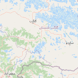
Map view of Gurez National Park

Use this park location map to pinpoint Gurez National Park in Pakistan, understand its exact geographic position, and read its mapped placement within the surrounding landscape more clearly.

Pigeon | © OpenStreetMap contributors
Park atlas

Compare other protected areas within the broader Himalayan mountains, tracing adjacent regional geography and conservation landscapes.

Explore Other National Parks and Protected Areas Near Gurez National Park

After exploring Gurez National Park, discover other national parks and protected areas in the surrounding Himalayan region, comparing diverse mountain terrain and alpine ecosystems. This structured view offers an atlas-style comparison of regional park geography, conservation strategies, and the diverse spread of protected landscapes across the Himalayas.
National parkGilgit-Baltistan
About 28 km away#1 closest

East

Himalaya National Park: Exploring Its Protected Boundaries and Mountainous Landscape in Gilgit-Baltistan

Mapped protected area within Pakistan's northern mountain region.

Himalaya National Park serves as a significant protected entity within the dramatic geography of Gilgit-Baltistan, Pakistan. This national park offers a focused view of its specific natural terrain and mapped boundaries, contributing to a broader atlas of conservation lands. Users can discover the park's role as a protected landscape, examining its integration within the regional context and understanding its unique geographic characteristics. The focus here is on the park's protected status and its place in the mapped natural environment of Northern Pakistan.

Area
2,263 km²
Established
2021
IUCN
II
Relief
Mountain
National parkGilgit-Baltistan
About 39 km away#2 closest

Northeast

Deosai National Park: A Premier High-Altitude Alpine Wilderness and Protected Landscape in Pakistan

Mapped boundaries and unique terrain within Gilgit-Baltistan's geography.

Deosai National Park is a key protected area in Pakistan's Gilgit-Baltistan region, characterized by its high-altitude alpine meadows and expansive plateau terrain. As a national park, it offers crucial insights into mapped landscapes and regional geography, particularly for understanding conservation efforts in extreme environments. The park's setting provides a unique lens through which to explore the distribution and characteristics of protected lands within the broader atlas of natural landscapes.

Area
3,584 km²
Established
1993
IUCN
Ib
Relief
Highland
Nature reserveJammu and Kashmir
About 45 km away#3 closest

Southwest

Wular Lake Nature Reserve: Protected Wetland and Freshwater Geography in the Kashmir Valley

Tectonic freshwater lake and Ramsar-recognized protected area.

Wular Lake stands as one of the largest freshwater bodies in South Asia, characterized by its tectonic origin and its role as a critical component of the Jhelum River catchment. The protected nature reserve landscape currently encompasses a mosaic of open water, reed beds, and muddy shallows that provide habitat for endemic snowtrout and migratory bird populations throughout the Kashmir Valley.

Established
1990
Relief
Lowland
Climate
Temperate
Scope
Terrestrial
National parkGilgit-Baltistan
About 53 km away#4 closest

Northwest

Nanga Parbat National Park: Protected Himalayan Landscape and Geographic Atlas

Explore mapped boundaries and alpine terrain in Gilgit-Baltistan.

Nanga Parbat National Park is a vast protected area defined by its spectacular Himalayan setting and dramatic alpine geography within Gilgit-Baltistan, Pakistan. As a national park, it safeguards the immense Nanga Parbat massif, its surrounding glaciers, and diverse altitudinal landscapes. This page offers an atlas perspective for understanding the park's geographic scope, its mapped natural features, and its significance as a protected mountain wilderness.

Area
1,785.61 km²
Established
2021
IUCN
II
Relief
Mountain
National parkAzad Kashmir
About 62 km away#5 closest

Northwest

Ghamot National Park: Pakistan National Park Atlas and Protected Landscape

Explore mapped boundaries and regional geography in Azad Kashmir.

Ghamot National Park represents a cornerstone for protected area exploration in Pakistan, situated within the dramatic mountainous terrain of Azad Kashmir. As a national park, it is recognized for its critical function as a wildlife corridor, especially for the survival of the Himalayan Brown Bear, and harbors diverse avian populations. This page offers detailed insight into its geographic context and its significance within a broader regional conservation strategy, providing rich data for atlas-based discovery.

Established
2004
IUCN
II
Relief
Mountain
Access
Remote access
National parkSrinagar district
About 70 km away#6 closest

South

Dachigam National Park: Protected Landscape Atlas and Geographic Context in Srinagar District

Mapped boundaries and natural terrain within India's national park system.

Gain insight into Dachigam National Park, a significant protected area located in the Srinagar district. This page provides detailed geographic context and an atlas-style view of its protected landscape. Understand its specific role as a national park and explore its mapped features, contributing to a comprehensive understanding of India's natural territories.

Area
141 km²
Established
1910
IUCN
II
Relief
Mountain
Protected areaJammu and Kashmir
About 71 km away#7 closest

South

Hokersar Protected Area: Wetland Geography and Map Context in Jammu and Kashmir

Migratory bird sanctuary and critical Jhelum basin wetland

Hokersar encompasses a distinct wetland landscape in northwestern India, characterized by shallow water, reed beds, and marshy pastures. As a key node for Palearctic waterbirds in the Kashmir Valley, the reserve provides essential flood-buffering services through its perennial stream network and seasonal snowmelt cycles, making it a focal point for regional ecological study.

Area
13.75 km²
Visitors
500K annual
Relief
Lowland
Climate
Temperate
National parkPakistan
About 72 km away#8 closest

Northwest

Lulusar-Dudipatsar National Park: Pakistan's Dramatic Western Himalayan Protected Area

Explore alpine lakes, mountain scenery, and protected landscape geography.

Lulusar-Dudipatsar National Park stands as a remarkable protected landscape within Pakistan's Western Himalayas. The park's geography is defined by towering peaks and a series of pristine glacial lakes, including the iconic Dudipatsar and Lulusar lakes. Users can explore its mapped terrain and understand its significance as a high-altitude ecosystem and a key component of Pakistan's protected areas network.

Established
2003
IUCN
II
Relief
Mountain
Climate
Alpine

Common questions about visiting, size, designation, and location context for Gurez National Park

Gurez National Park FAQs for park facts, access, geography, and protected area context

Find quick answers about Gurez National Park, including protected-area facts, park geography, trail and visitor context, and how the park fits into its surrounding country and regional landscape.
MoriAtlas Explorer

Continue Your Protected Areas Search Across the Global Atlas

Deepen your exploration by continuing the structured search for national parks and protected areas worldwide. Utilize the comprehensive filtering capabilities to compare different conservation landscapes and refine your understanding of global park geography. Discover more about the distribution and characteristics of protected natural areas.

Global natural geography