Peaks
장산
137 m

A comprehensive analysis of terrain, environmental zones, and boundary data.
Investigate the physical geography and administrative distribution of Gyeongju National Park in North Gyeongsang Province. This profile details the 137.09 square kilometer landscape, characterized by mixed terrain and diverse natural features, including significant peaks and coastal environments across the region.
Related tags
South Korea's only national park dedicated to preserving ancient Silla dynasty heritage and archaeological treasures
Gyeongju National Park is South Korea's sole national park designated primarily for its historical and cultural significance rather than natural landscapes. Located in and around the city of Gyeongju in North Gyeongsang Province, the park encompasses a remarkable collection of Silla dynasty archaeological sites spanning over a millennium of Korean history. The park was established on December 31, 1968, making it one of South Korea's earlier national park designations. Unlike typical protected areas that focus on wilderness and biodiversity, Gyeongju National Park protects an extraordinary concentration of ancient palaces, temples, tombs, stone monuments, and Buddhist carvings set within a mountainous landscape. The park is divided into eight non-contiguous sections scattered around the Gyeongju metropolitan area, each containing distinct clusters of historical monuments. This unique designation reflects the park's role as a living museum of Korean civilization, where visitors can walk through ancient temple grounds, explore royal tomb mounds, and contemplate carved Buddhist statues amid forested hills.
Coastal park status in North Gyeongsang Province and American Samoa
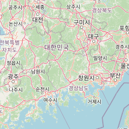
Spatial dimensions and coordinates across 137 square kilometers
Mixed relief classifications and recorded geographic features within the protected boundary
Peaks
137 m
Rock formations
Rock formations
Peaks
594 m
Peaks
624.5 m
Mountain saddles
Temperate climate zones, mixed relief, and coastal and mountain landscapes
Mountains · Coast · Lakes
Trace the regional geography and compare other protected landscapes surrounding Gyeongju National Park
North

Mapped terrain, park boundaries, and natural landscapes.
Juwangsan National Park is a protected natural area situated within South Korea's Taebaek mountain range, renowned for its steep valleys, waterfalls, and dense forests. This park offers a rich landscape context, showcasing dramatic ridgelines and providing a significant example of South Korea's protected mountain terrain. Discover its geographic placement, mapped protected boundaries, and the unique natural and cultural elements that define this national park.
West
Discover Protected Landscape and Regional Terrain
Gayasan National Park presents a distinct protected-area entity within South Gyeongsang Province, serving as a crucial point for atlas-driven geographic exploration. As a designated national park in South Korea, it offers insights into its specific mapped boundaries and the surrounding natural terrain. Understanding this park's role within the regional geography provides a foundational element for comprehending broader landscape patterns and protected land distribution across the country.
West
Explore its protected land boundaries and regional landscape context.
Examine Deogyusan National Park, a designated national park situated in the Jeollabuk-do region of South Korea. This entry provides critical geographic context, focusing on the park's mapped boundaries and its role as a protected landscape. Users can gain a structured understanding of its natural terrain and regional significance, contributing to a broader atlas of protected areas.
Northwest
Discover South Korea's Songnisan National Park and its protected terrain.
Delve into the protected landscape of Songnisan National Park, a key national park entity in South Korea. This atlas-focused view highlights its mapped geographic boundaries and natural terrain, providing essential context for understanding conservation areas. Explore Songnisan National Park as a distinct protected region contributing to the country's diverse geography and mapped natural heritage.
Northwest
Explore its park boundaries and regional geography.
Sobaeksan National Park represents a crucial protected area within the mountainous terrain of Chungcheongbuk-do, South Korea. As a designated national park, it offers a valuable point of reference for understanding regional geographic distribution and landscape context across the Korean Peninsula. This park's identity as a protected natural landscape contributes significantly to the atlas-based exploration of conservation areas and their environmental settings.

Northwest
Discover its mapped mountain terrain and protected landscape identity.
Woraksan National Park offers a detailed view of protected mountain landscapes within South Korea's Gyeongsangbuk-do region. The park is characterized by its prominent Mount Worak, steep ridgelines, and dense forested terrain, contributing significantly to the nation's network of protected areas. Users can explore the geographic context, mapped boundaries, and ecological significance of this vital national park, understanding its place in the broader regional atlas and natural landscape context.
Southwest
Explore the mapped terrain and protected area geography.
Jirisan National Park is a key protected area within South Korea, serving as a vital component of the nation's natural landscape. This atlas-focused content provides detailed geographic information, highlighting the park's mapped boundaries and its role within the regional context of the Korean Peninsula. Understand the distinct characteristics of this protected national park for comprehensive geographic discovery.
Southwest
Explore mapped protected area boundaries and natural terrain.
As a designated national park in South Korea, Hallyeohaesang National Park offers a distinct geographic profile crucial for atlas exploration. This entry focuses on its protected landscape features, mapped territorial extent, and regional context within the Republic of Korea. Understand the park's specific geographical markers and its significance as a mapped protected area.
Delve deeper into understanding Gyeongju National Park's role as a protected landscape within North Gyeongsang Province. This focused exploration reveals its mapped boundaries and regional geographic placement, vital for anyone building a comprehensive atlas of protected areas. Engage with the structured data to grasp the specific natural landscape attributes and its position in South Korea's conservation geography.