
Viewpoints
Park geography
A detailed look at the physical terrain, elevation gradients, and natural features
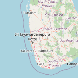
Horton Plains National Park Geographic Profile and Mapped Regional Landscape Context
The geographic profile of Horton Plains National Park encompasses a 31.6 square kilometer area within the Central Province of Sri Lanka. This high altitude alpine environment features elevations reaching 2389 meters, including mountain peaks, waterfalls such as Baker's Falls, and viewpoints like World's End.
Related tags
Montane GrasslandCloud ForestEndemic BiodiversityWorld Heritage SiteHighland Ecosystems
Highland plateau preserve with dramatic cliffs and endemic cloud forest ecosystems
Horton Plains National Park
Horton Plains National Park is a protected area in the central highlands of Sri Lanka, situated at elevations between 2,100 and 2,300 meters above sea level. The park encompasses approximately 3,160 hectares of montane grassland and cloud forest, making it one of the highest and most ecologically significant protected areas in Sri Lanka. Established as a nature reserve in 1969 and elevated to national park status in 1988, Horton Plains forms part of the Central Highlands World Heritage Site, inscribed in 2010 alongside Peak Wilderness Sanctuary and the Knuckles Mountain Range. The park is distinguished by its dramatic topography, serving as the headwaters for three major Sri Lankan rivers—the Mahaweli, Kelani, and Walawe—and featuring the spectacular sheer cliff known as World's End, which drops 870 meters into the valley below. The combination of high-altitude grassland, montane forest, and unique geological conditions has produced an ecosystem of exceptional biodiversity, with numerous plant and animal species found nowhere else on Earth.
- Location
- Sri Lanka
- Park type
- National park
- Established
- 1988
- Area
- 31.6 km²
- Highest point
- 2,389 m
Location overview
National and regional location overview for Central Province
Horton Plains National Park Geographic and Regional Overview
Horton Plains National Park lies within Sri Lanka, Zambia, and American Samoa, with ties to Central Province. The inland protected area operates as a non-transboundary territory with no coastal or marine boundaries.
- Countries
- Sri Lanka, Zambia
- Regions
- Central Province
- Primary location
- Central Province
- Geographic setting
- Inland
Boundary and coordinates
Analyzing the geographic span and 31.6 square kilometer total area.
Horton Plains National Park Boundary Map and Spatial Limits
Mapped geometry outlines the physical limits of Horton Plains National Park to provide geographic context. Derived facts detail the 31.6 square kilometer area along with calculated perimeter, center, and coordinate span data.
- Boundary area
- 32.2 km²
- Boundary perimeter
- 25.1 km
- Northernmost point
- 6.8396° N
- Southernmost point
- 6.7739° N
- Easternmost point
- 80.8378° E
- Westernmost point
- 80.7664° E
- Geographic centre
- 6.8062° N, 80.7978° E
- North–south span
- 7.3 km
- East–west span
- 7.9 km
Elevation and terrain
Explore recorded vertical relief ranges and specific interior natural features
Horton Plains National Park Elevation Profile and Mountain Terrain Geography
This elevation summary outlines mountain terrain data ranging from twelve hundred to twenty-three hundred meters across the protected area. Linked feature cards document official names, types, and spatial relationships for interior waterfalls, peaks, and viewpoints.
- Minimum elevation
- 1,200 m
- Maximum elevation
- 2,300 m
- Highest point
- 2,389 m
Selected named natural features
Rivers
Belihul Oya
Peaks
Agrabopath
2,320 m
Waterfalls
Slab Rock Falls
Viewpoints
World's End (Plate 1)
Streams
Agara Oya
Environmental setting
Alpine climate zones, montane forests, and major water features across the protected landscape
Horton Plains National Park Environmental Setting and Physical Geography Classifications
Stored landscape features, habitat types, and relief categories provide complementary perspectives on the physical setting of Horton Plains National Park. Recorded classifications link directly to relevant atlas destinations for broader regional geography context.
- Relief
- Mountain
- Climate
- Alpine
- Water
- Major water bodies
- Forest cover
- Partial forest
- Seasonality
- Seasonal
Landscape features
Mountains · Cliffs · Forest · Grassland · Wetland · Lakes · Rivers · Waterfalls
Habitat types
Montane forest · Alpine meadow · Grassland · Wetland · Riverine habitat
Park atlas
Map connected protected landscapes and high-altitude ecosystems throughout Sri Lanka's Central Highlands, exploring regional park geography.
Discover Other National Parks and Protected Areas Near Horton Plains National Park in Sri Lanka
After exploring Horton Plains National Park, browse other national parks and protected areas across Sri Lanka's Central Highlands and surrounding montane landscapes. Compare diverse ecosystems, from cloud forests to highland grasslands, and understand their regional conservation context within this significant World Heritage Site.
National parkCentral Province
About 15 km away#1 closest
North

Galways Land National Park: A Protected Landscape within Central Province, Sri Lanka
Explore the mapped geography and protected area context of this national park.
Galways Land National Park is a designated national park within the Central Province of Sri Lanka, offering a distinct focus for geographic exploration. This entry provides specific details on its protected landscape characteristics and its place within the regional atlas. Users can examine the mapped boundaries and understand the natural terrain that defines this conservation area. Discover the unique geographic identity of Galways Land National Park and its contribution to the protected areas network.
- Area
- 0.27 km²
- Established
- 2006
- IUCN
- II
- Relief
- Mountain
National parkSri Lanka
21 km away#2 closest
South
Udawalawe National Park: National Park Protected Landscape and Geographic Atlas
Explore Sri Lanka's mapped natural terrain and park boundaries.
Gain a comprehensive atlas-level understanding of Udawalawe National Park, a key protected landscape in Sri Lanka. This entry focuses on the park's distinct geographic identity, its mapped boundaries, and its significance as a protected area within the island's diverse natural terrain. Explore how this national park contributes to the regional geography and provides structured insights for landscape discovery.
- Area
- 308.21 km²
- Established
- 1972
- IUCN
- II
- Visitors
- 188.4K annual
National parkSri Lanka
43 km away#3 closest
Southeast
Lunugamvehera National Park: Sri Lanka's Protected Area Mapping and Geographic Identity
Mapped terrain and national park boundaries in Sri Lanka.
Lunugamvehera National Park is a dedicated national park situated in Sri Lanka. This entry facilitates a focused exploration of its protected landscape, offering insight into its mapped geography and position within the country's conservation network. Understand the park's role and its physical characteristics through detailed geographic and atlas-oriented information.
- Area
- 234.988 km²
- Established
- 1995
- IUCN
- II
- Relief
- Lowland
National parkSouthern Province
50 km away#4 closest
Southeast
Yala National Park: National Park Protected Landscape and Geographic Exploration
Mapped boundaries and regional context in Southern Province
Investigate Yala National Park, a protected national park situated in the Southern Province of Sri Lanka. This entry focuses on its geographic identity, detailing mapped boundaries and the surrounding landscape context crucial for atlas-based exploration and understanding protected area distributions. Gain insight into the park's role as a significant natural landmark.
- Area
- 978.807 km²
- Established
- 1938
- IUCN
- II
- Visitors
- 400K annual
National parkUva Province
67 km away#5 closest
Northeast
Gal Oya National Park: Protected Landscape and Reservoir Geography in Uva Province
Explore savannah grasslands, elephant populations, and mapped terrain.
Gal Oya National Park presents a unique protected landscape within Uva Province, Sri Lanka. This national park is defined by its broad savannah grasslands, known as thalawa, interspersed with forested hills and the vast Senanayake Samudraya reservoir. Its varied topography, from lowlands to mountain peaks, offers a rich canvas for geographic exploration and understanding protected-area dynamics. The park's consistent visibility of elephant populations across these diverse terrains makes it a key site for wildlife observation within Sri Lanka's atlas of natural heritage.
- Area
- 259 km²
- Established
- 1954
- IUCN
- II
- Relief
- Mountain
National parkEastern Province
68 km away#6 closest
Northeast
Maduru Oya National Park: Sri Lanka National Park Landscape and Geographic Context
Mapped protected area boundaries within Eastern Province.
Maduru Oya National Park represents a distinct protected area within the Eastern Province of Sri Lanka, offering valuable geographic context for atlas-based exploration. This national park's mapped boundaries and its placement within the regional landscape provide critical data points for understanding conservation geography. Discover the park's identity as a protected natural landscape and its role in the broader geographic atlas of Sri Lanka.
- Area
- 588.5 km²
- Established
- 1983
- IUCN
- II
- Relief
- Mountain
National parkSri Lanka
77 km away#7 closest
South
Ussangoda National Park: Sri Lanka's National Park and Protected Landscape Atlas Entry
Mapped protected boundaries and regional geographic context.
Ussangoda National Park represents a vital component of Sri Lanka's protected natural areas, offering unique insights into its landscape and geography. This atlas entry focuses on the park's identity as a national park, providing a detailed view of its mapped boundaries and its specific location within the island's diverse geography. Understand the protected land context and the unique characteristics that define Ussangoda National Park for focused geographic discovery.
- Area
- 3.49 km²
- Established
- 2010
- IUCN
- II
- Relief
- Upland
National parkSouthern Province
About 78 km away#8 closest
Southeast
Bundala National Park: A Ramsar Wetland & UNESCO Biosphere Reserve in Southern Province
Explore its unique coastal geography and mapped bird habitats.
Bundala National Park is a critical protected area situated in Sri Lanka's Southern Province, defined by its system of five shallow brackish lagoons, salt pans, and coastal dune ecosystems. Recognized globally as a Ramsar wetland and UNESCO Biosphere Reserve, it serves as a crucial wintering ground for migratory water birds, most famously large flocks of greater flamingos. The park's extremely low-lying coastal terrain, with unique palu tree forests on sand dunes, offers a distinct landscape for geographic discovery and understanding regional protected areas.
- Area
- 33.39 km²
- Established
- 1993
- IUCN
- II
- Relief
- Lowland
MoriAtlas Explorer
Continue Exploring Horton Plains National Park's Geographic and Landscape Context
Deepen your understanding of Horton Plains National Park by examining its specific geographic features and mapped park boundaries. Discover its role within the broader atlas of protected areas in Sri Lanka and how its landscape contributes to regional geographic understanding. This exploration helps contextualize the park's protected status and its unique natural terrain for detailed atlas discovery.
Browse next
Global natural geography
Explore related park routes
Explore MoriAtlas Global ParksBrowse All MoriAtlas ParksGlobal Park Map DiscoveryMoriAtlas: Browse All CountriesBrowse All MoriAtlas ContinentsNational Park Environment AtlasGrand Canyon National Park AtlasYellowstone National Park AtlasYosemite National Park Atlas and GeographySerengeti National Park AtlasGalápagos National Park Protected LandscapeBanff National Park Geography and AtlasKruger National Park Atlas EntryUluṟu-Kata Tjuṯa National Park AtlasExplore Uluru-Kata Tjuta National Park GeographyPlitvice Lakes National Park AtlasFiordland National Park Protected LandscapeGreat Smoky Mountains National Park AtlasAfghanistan National Parks and Protected AreasAlbania National Parks and Protected AreasAlgeria National Parks and Protected AreasAmerican Samoa National Parks and Protected AreasAndorra National Parks and Protected AreasAngola National Parks and Protected AreasAntarctica National Parks and Protected AreasAntigua and Barbuda Park List