
Islands
Park geography
A detailed look at the island terrain, coastal extents, and regional geography
Houtman Abrolhos Islands National Park Geographic Profile, Boundaries, and Landscape Data
Examine the technical geographic scope of Houtman Abrolhos Islands National Park, including its total recorded boundary span and maritime terrain. This structured profile maps the distribution of islands and coastal landmarks that define this protected area within Western Australia.
Related tags
islandscoral reefsseabird coloniesmarine parkWestern Australia
Remote island chain guarding Western Australia's mid-west coast
Houtman Abrolhos Islands National Park
Houtman Abrolhos Islands National Park protects a scattered archipelago of more than 200 islands lying roughly 75 kilometres off the coast of Geraldton in Western Australia's Mid West region. These islands form the most northerly true coral reef system in the southern hemisphere and represent a unique convergence of marine, terrestrial, and avian ecosystems. The national park was formally established in July 2019, coinciding with the 400th anniversary of the islands' first recorded European sighting by Dutch navigator Frederik de Houtman in 1619. The park encompasses three distinct island groups the Wallabi Group in the north, the Easter Group centrally, and the Pelsaert Group in the southern reaches, each offering different landscapes and ecological characteristics. The islands serve as critically important breeding grounds for numerous seabird species and support isolated yet biologically significant terrestrial communities despite their small land areas.
- Location
- Australia
- Park type
- National park
- Established
- 2019
- Area
- 15.6 km²
Location overview
Island and coastal marine geography in the Mid West region
Geographic Profile of Houtman Abrolhos Islands National Park, Australia
Located in the Mid West of Western Australia, Houtman Abrolhos Islands National Park remains a key reserve in Australia. Geographic profiles define the park as a coastal, island, and marine territory within one nation.
- Countries
- Australia
- Regions
- Mid West, Western Australia
- Primary location
- Australia
- Geographic setting
- Coastal · Island · Marine
Boundary and coordinates
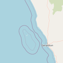
Mapping the 15.64 square kilometer extent and geographic coordinates.
Houtman Abrolhos Islands National Park Boundary Map and Geographic Extent
The mapped boundary outline provides critical spatial context for Houtman Abrolhos Islands National Park. Accompanying geographic facts outline estimated total area, center coordinates, and spatial spans to aid regional analysis.
- Boundary area
- 15.6 km²
- Boundary perimeter
- 142.7 km
- Northernmost point
- 28.2902° S
- Southernmost point
- 28.9872° S
- Easternmost point
- 114.042° E
- Westernmost point
- 113.5863° E
- Geographic centre
- 28.5366° S, 113.7444° E
- North–south span
- 77.3 km
- East–west span
- 44.6 km
Terrain and natural features
Classified lowland terrain profiles and recorded insular geography
Houtman Abrolhos Islands National Park Terrain and Named Features
Recorded terrain classifications indicate lowland relief across the protected landscape alongside multiple documented islands, peaks, and capes. Associated feature cards provide specific names, types, and spatial relationships within the boundary.
Selected named natural features
Peaks
Flag Hill
15 m
Capes
Wreck Point
Islands
White Island
Islands
East Wallabi Island
Islands
Jon Jim Island
Environmental setting
Marine, coastal, and lowland topography classifications across island terrain
Houtman Abrolhos Islands National Park Environmental Classifications and Setting
Stored landscape and habitat properties organize the physical setting into distinct marine, coastal, and lowland categories. Recorded classifications connect directly to broader atlas destinations sharing similar environmental traits.
- Relief
- Lowland
- Water
- Major water bodies
- Forest cover
- No forest cover
- Seasonality
- Year-round
Landscape features
Islands · Beach · Coast
Habitat types
Coastal habitat · Marine habitat
Park atlas
Trace the geographic spread of coastal protected areas and island ecosystems in Western Australia's Mid West, extending from Geraldton's offshore marine zones.
Discover Nearby Protected Areas: Houtman Abrolhos Islands National Park and Surrounding Marine Landscapes
Continue your exploration beyond Houtman Abrolhos Islands National Park by browsing other national parks and protected areas across Western Australia's Mid West region. Compare these diverse marine and coastal conservation landscapes to understand their interconnected geography, ecological significance, and unique protected features.
National parkWestern Australia
69 km away#1 closest
Northeast

Kalbarri National Park: Discover Its Mapped Geography and Protected Landscape Identity
Western Australia's protected national park terrain.
Kalbarri National Park is a vital protected area within the vast geography of Western Australia. This detail entry provides essential context for understanding the park's specific protected landscape, its geographic features, and how it integrates into the broader regional atlas. Explore the mapped boundaries and natural terrain that define Kalbarri National Park, offering a foundation for deeper geographic study and protected-area discovery.
- Area
- 1,830.05 km²
- Established
- 1963
- IUCN
- II
- Relief
- Mixed relief
Nature reserveWestern Australia
122 km away#2 closest
Northeast
Eurardy Reserve Nature Reserve: Geographic Context and Protected Landscape Profile
Sandplain terrain and conservation corridors in Western Australia
Eurardy Reserve stands as a pivotal nature reserve in Western Australia, offering a unique look at intact sandplain ecosystems and Mallalie scrub associations. Positioned near Kalbarri National Park, the area provides vital habitat connectivity and botanical value. Users can explore its flat, undulating terrain and seasonal landscape transitions through this structured geographic overview of the Mid West region.
- Area
- 300.5 km²
- Established
- 2005
- Relief
- Lowland
- Climate
- Mediterranean
National parkWestern Australia
152 km away#3 closest
Southeast
Lesueur National Park: Detailed National Park Atlas and Geographic Context
Explore the mapped protected landscape in Western Australia.
Lesueur National Park is a key protected area within the expansive geography of Western Australia. This resource provides detailed information on its national park status, mapped boundaries, and its significance within the regional atlas. Engage with the specific landscape identity of this protected territory and understand its role in the broader geographic context of Australia.
- Area
- 272.35 km²
- Established
- 1992
- IUCN
- II
- Relief
- Upland
National parkWestern Australia
172 km away#4 closest
Southeast
Tathra National Park: Protected Landscape Identity and Mapped Geographic Boundaries
Western Australia national park exploration and regional context.
Delve into the protected landscape of Tathra National Park, a significant entity within Western Australia's network of natural areas. This detail provides a structured overview of its geographic position, mapped outlines, and ecological context, serving as a vital entry point for understanding Australia's diverse protected lands and regional geography.
- Area
- 43.22 km²
- Established
- 1970
- IUCN
- II
- Relief
- Upland
National parkWestern Australia
173 km away#5 closest
Southeast
Drovers Cave National Park: Protected National Park Landscape in Western Australia
Discover the mapped geography and natural context of this park.
Drovers Cave National Park stands as a key protected area within the expansive Western Australian region. This national park offers a focused lens through which to explore its specific geographic identity and landscape characteristics. As a designated national park, it is mapped within the larger atlas of Australia's protected lands, providing users with structured insights into its regional setting and natural terrain.
- Area
- 26.81 km²
- Established
- 1972
- IUCN
- II
- Relief
- Lowland
National parkWestern Australia
187 km away#6 closest
Southeast
Alexander Morrison National Park: Discover Its Protected Landscape and Regional Geography
Mapped protected area boundaries and landscape context in Western Australia.
Alexander Morrison National Park represents a core protected natural landscape within Western Australia. As a national park, its identity is deeply tied to its mapped geographic extent and its role in the regional atlas. This destination provides a focused lens on a specific protected area, enabling users to understand its unique landscape features and its contribution to the conservation estate of Western Australia. Delve into its protected status and geographic orientation within Australia's largest state.
- Area
- 85 km²
- Established
- 1970
- IUCN
- II
- Relief
- Upland
National parkWestern Australia
199 km away#7 closest
Southeast
Nambul National Park: A Protected Landscape Within Western Australia's Geographic Context
Explore mapped boundaries and regional terrain context.
Nambul National Park represents a distinct protected area within the expansive geography of Western Australia. This detailed park page offers users an atlas-driven exploration of its identity as a national park, highlighting its mapped natural landscape and its regional significance. Understand the specific geographic features and protected land context that define Nambul National Park within Australia's largest state, fostering deeper geographic discovery.
- Area
- 192.68 km²
- Established
- 1994
- IUCN
- II
- Relief
- Upland
National parkWestern Australia
207 km away#8 closest
Southeast
Badgingarra National Park: Mapped Boundaries and Protected Landscape Exploration
Explore its national park designation and regional geography.
Delve into the protected landscape identity of Badgingarra National Park, a designated national park situated in Western Australia. This entry provides detailed atlas-level information, focusing on the park's geographic scope, mapped boundaries, and its significance as a protected natural area. Understand its terrain and regional context for a deeper appreciation of Western Australia's conservation landscapes.
- Area
- 131.08 km²
- Established
- 1973
- IUCN
- II
- Relief
- Mixed relief
MoriAtlas Explorer
Continue exploring Houtman Abrolhos Islands National Park's geographic context and protected landscape
Deepen your understanding of Houtman Abrolhos Islands National Park by examining its specific geographic attributes and mapped boundaries. This national park offers a crucial element for comprehending Australia's protected areas atlas and the intricate relationships between landscapes. Continue your exploration to reveal the full scope of this protected area's significance within the regional geography.
Browse next
Global natural geography
Explore related park routes
Explore MoriAtlas Global ParksBrowse All MoriAtlas ParksGlobal Park Map DiscoveryMoriAtlas: Browse All CountriesBrowse All MoriAtlas ContinentsNational Park Environment AtlasGrand Canyon National Park AtlasYellowstone National Park AtlasYosemite National Park Atlas and GeographySerengeti National Park AtlasGalápagos National Park Protected LandscapeBanff National Park Geography and AtlasKruger National Park Atlas EntryUluṟu-Kata Tjuṯa National Park AtlasExplore Uluru-Kata Tjuta National Park GeographyPlitvice Lakes National Park AtlasFiordland National Park Protected LandscapeGreat Smoky Mountains National Park AtlasAfghanistan National Parks and Protected AreasAlbania National Parks and Protected AreasAlgeria National Parks and Protected AreasAmerican Samoa National Parks and Protected AreasAndorra National Parks and Protected AreasAngola National Parks and Protected AreasAntarctica National Parks and Protected AreasAntigua and Barbuda Park List