Mori Atlas logo
National parkJim Corbett National Park

Discover the mapped boundaries and regional geography of this significant protected area.

Jim Corbett National Park: Uttarakhand's Premier National Park and Protected Landscape

Jim Corbett National Park stands as a key protected landscape within the northern Indian state of Uttarakhand, offering a unique focus for atlas exploration and geographic discovery. This national park represents a vital component of the region's natural heritage, characterized by its mapped boundaries and distinct ecological context. Users can delve into the specific geography and protected area identity of Jim Corbett National Park, understanding its placement within the broader Himalayan terrain and its significance as a conservation landscape.

National ParkTiger ReserveWildlife ConservationProject TigerDeciduous ForestHimalayan Foothills

Jim Corbett National Park

National park

Park overview

Structured park overview, official facts, and landscape profile for Jim Corbett National Park

Jim Corbett National Park park facts, protected area profile, and essential visitor context
Review the core facts for Jim Corbett National Park, including designation, size, terrain, visitor scale, habitats, and operating context in one park-focused overview.

About Jim Corbett National Park

Jim Corbett National Park stands as a landmark of Indian conservation history and ecological importance. Established as Hailey National Park in 1936, it became the first national park in Asia and was subsequently renamed Corbett National Park in honour of Jim Corbett, the British hunter and naturalist who played a pivotal role in its creation. The park is situated in the Nainital district of Uttarakhand, occupying the Patli Dun valley formed by the Ramganga river between the Lesser Himalaya and the Siwalik Hills. The reserve encompasses approximately 1,288 square kilometres, including a core zone of 822 square kilometres and a buffer zone of 466 square kilometres. The landscape is characterised by ridges, ravines, minor streams, and plateaus with varying aspects and slopes. The park's moist deciduous forests are dominated by sal trees, which cover nearly three-quarters of the area, interspersed with grasslands that comprise about 10 percent of the total terrain. The Ramganga river and its reservoir create additional aquatic habitat, supporting rich biodiversity. As India's first Project Tiger reserve launched in 1974, Corbett has served as a model for tiger conservation across the country, with the park's tiger population of approximately 260 individuals representing one of the most viable and visible tiger populations in India.

Quick facts and research context for Jim Corbett National Park

Located in Nainital district, Uttarakhand, Jim Corbett National Park is India's oldest national park and the first to join the Project Tiger conservation program in 1974. The park protects a diverse landscape of moist deciduous forest, grasslands, and riverine habitats in the sub-Himalayan Doon Valley. It harbours substantial populations of Bengal tigers, Indian elephants, and numerous deer species. The reserve includes a core zone of about 520.8 square kilometres and a larger buffer zone, with the Ramganga river flowing through the Patli Dun valley. The park receives monsoonal rainfall from July to September and experiences temperate conditions year-round.

Park context

Deeper park guide and search-rich context for Jim Corbett National Park

Jim Corbett National Park history, landscape, wildlife, and travel context
Explore Jim Corbett National Park through its history, landscape character, ecosystems, wildlife, conservation priorities, cultural context, and seasonal travel timing in a structured park guide built for atlas discovery and search intent.

Why Jim Corbett National Park stands out

Jim Corbett National Park is best known as India's premier tiger reserve and the birthplace of Project Tiger, the country's flagship conservation initiative. The park is famed for its successful tiger conservation story, with approximately 260 tigers inhabiting its forests according to the 2022 census. Its diverse landscape of sal forests, grasslands, and river corridors provides ideal habitat for both tigers and elephants, with the park supporting one of the highest densities of tigers in India. The park's historical significance as Asia's first national park, established in 1936 and named after the legendary hunter-turned-conservationist Jim Corbett, adds to its prominence. Corbett is also notable for its elephant-mounted safari experiences and the Dhikala forest rest house, which offers visitors a classic wilderness immersion in the heart of the reserve.

Jim Corbett National Park history and protected-area timeline

The conservation history of Jim Corbett National Park traces back to the 19th century when British forest officials recognised the ecological value of the region's forests. Some areas of the present park were formerly part of the princely state of Tehri Garhwal, where the forests were cleared by the Uttarakhand Forest Department to reduce vulnerability to Rohilla invaders. Following British intervention, the Buksa tribe, who had settled in the Terai, were evicted in the early 1860s. Major Ramsay, the British officer in charge, initiated efforts to protect the forests beginning in 1868, when the British forest department established control and prohibited cultivation and cattle operations. In 1879, these forests were constituted as a reserve forest permitting restricted felling. Early 20th-century British administrators, including E.R. Stevans and E.A. Smythies, advocated for establishing a national park, with the British administration considering a game reserve in 1907. The process culminated in 1936 when the Hailey National Park covering 323.75 square kilometres was created under Governor Sir Malcolm Hailey, becoming Asia's first national park. The reserve was renamed Ramganga National Park in 1954-1955 and again to Corbett National Park in 1955-1956, honouring Jim Corbett. During World War II, the park suffered from poaching and timber cutting. The park was chosen in 1974 as the launch site for Project Tiger, and buffer zones totalling 797.72 square kilometres were added in 1991, including the Kalagarh forest division and Sonanadi Wildlife Sanctuary.

Jim Corbett National Park landscape and geographic character

Jim Corbett National Park occupies a distinctive position in the sub-Himalayan belt, situated in the Doon Valley between the Lesser Himalaya in the north and the Siwalik Hills in the south. The terrain exhibits a characteristic Doon valley structure with longitudinal valleys formed along narrow tectonic zones between lineaments. The geology features upper tertiary rocks exposed towards the base of the Shiwalik range, with hard sandstone units forming broad ridges. The park encompasses the Patli Dun valley, created by the Ramganga river, which flows through the reserve and is impounded to form the Ramganga reservoir near the Kalagarh Dam in the southwest. The elevation ranges from 360 metres to 1,040 metres above sea level, creating a varied topography of ravines, ridges, minor streams, and small plateaus with differing aspects and slopes. The landscape includes dense forest-covered hills, open grasslands, riverine corridors, and marshy depressions. The Kalagarh Dam creates a significant water body that attracts migratory waterfowl during winter months. Corbett Falls, a 20-metre waterfall situated about 25 kilometres from Ramnagar, adds to the scenic diversity, surrounded by dense forests.

Jim Corbett National Park ecosystems, habitats, and plant life

The ecological character of Jim Corbett National Park is defined by its moist deciduous forests, grasslands, and riverine ecosystems that create a remarkably diverse habitat mosaic. Approximately 73 percent of the park is covered by dense moist deciduous forest dominated by sal trees, with additional species including peepal, rohini, and mango among 110 documented tree species. The total plant species count stands at 617, according to 2023 surveys. Grasslands cover about 10 percent of the area, providing critical foraging habitat for deer and elephants. The tree density varies across the park, with higher density in sal forests and lowest in Anogeissus-Acacia catechu forests. The forest exhibits healthy regeneration in certain communities including Mallotus philippensis, Jamun, and Diospyros species, though sal forest regeneration shows limitations. The Ramganga river and its reservoir support aquatic ecosystems, while marshy depressions add further ecological diversity. The park's position in the Terai Arc Landscape links it with protected areas across India and Nepal, facilitating wildlife corridors for tigers, elephants, and rhinoceroses.

Jim Corbett National Park wildlife and species highlights

Jim Corbett National Park harbours an impressive assemblage of wildlife, with 50 mammal species, 580 bird species, and 25 reptile species documented within its boundaries. The park is particularly renowned for its Bengal tiger population of approximately 260 individuals according to the 2022 census, representing one of India's most significant tiger populations. The tiger population includes individuals that have been observed killing and consuming large elephants, especially calves. The Indian elephant population numbers around 1,100 individuals based on 2019 counts. Predators include the Indian leopard, jungle cat, fishing cat, and leopard cat. The park supports substantial ungulate populations including chital, sambar deer, hog deer, and barking deer, which form the primary prey base for large predators. Other mammals include sloth bear, Asiatic black bear, Indian gray mongoose, otters, yellow-throated marten, Himalayan goral, Indian pangolin, langur, and rhesus macaque. The birdlife is exceptional, with over 586 resident and migratory species including crested serpent eagle, Indian paradise flycatcher, greater coucal, blossom-headed parakeet, red junglefowl, owls, and nightjars. Reptile species number at least 33, including the Indian python, while marsh crocodiles and gharials have been released into the Ramganga river. Additional fauna includes 7 amphibian species, 7 fish species, and 36 dragonfly species.

Jim Corbett National Park conservation status and protection priorities

Jim Corbett National Park represents a cornerstone of Indian wildlife conservation, serving as the flagship of Project Tiger since its launch in 1974. The park is part of the World Wide Fund for Nature's Terai Arc Landscape Program, which aims to protect three terrestrial flagship species—the tiger, Asian elephant, and Indian rhinoceros—by restoring wildlife corridors linking 13 protected areas across Nepal and India. An economic assessment estimated the annual flow benefits of the Corbett Tiger Reserve at approximately 14.7 billion rupees, including gene-pool protection worth 10.65 billion rupees, water provisioning to downstream districts, water purification services for Delhi, employment for local communities, habitat provision for wildlife, and carbon sequestration. The reserve has faced significant conservation challenges, including habitat loss from the construction of the Kalagarh Dam, which submerged 80 square kilometres of prime riverine habitat and led to local extinction of swamp deer and population decline in hog deer. Poaching was a serious concern in the late 1980s, with 109 cases recorded in 1988-89, though this dropped to 12 cases by 1997-98. Current threats include invasive species such as Lantana and Parthenium, human-wildlife conflict, and infrastructure development, with the NTCA expressing concern about weakened protection systems and poaching infiltration.

Jim Corbett National Park cultural meaning and human context

While Jim Corbett National Park is primarily known for its ecological significance, the region has historical human connections to the landscape. The areas comprising the park were formerly part of the princely state of Tehri Garhwal, with the Raja of Tehri ceding territory to the East India Company in return for assistance against Gurkha invaders. The Buksa tribe, indigenous to the Terai region, originally settled and cultivated the land before being evicted during British rule in the 1860s. The park is named after Jim Corbett, the British hunter and naturalist who famously hunted man-eaters in the region and later became a passionate advocate for wildlife protection. His book Man-Eaters of Kumoon brought international attention to the region and helped establish the reserve. The Garjiya Devi Temple, located on the banks of the Kosi river near the park, remains a sacred site visited during Kartik Purnima in November-December. Ecotourism has been encouraged since the 1990s, with nature guide training programs introduced to ensure local communities benefit from tourism while maintaining conservation objectives.

Top sights and standout views in Jim Corbett National Park

Jim Corbett National Park combines historical significance, ecological diversity, and conservation leadership as India's premier national park. The park's successful tiger population of approximately 260 individuals makes it one of the best places in India to observe tigers in the wild, while the presence of around 1,100 elephants adds to its megafauna appeal. The Dhikala forest rest house offers visitors a legendary wilderness experience at the fringes of the Patli Dun valley, with the Kanda ridge forming a dramatic backdrop. The Kalagarh Dam in the southwest attracts winter migratory waterfowl, while Corbett Falls provides a scenic waterfall surrounded by dense forests. The park's legacy as Asia's first national park, established in 1936 and named after Jim Corbett, gives it unique historical significance in the conservation movement. Elephant-mounted safaris offer a distinctive way to explore the park's terrain, and the 2022 tiger census confirms robust population numbers. The park's inclusion in the Terai Arc Landscape connecting Indian and Nepalese protected areas underscores its regional conservation importance.

Best time to visit Jim Corbett National Park

The optimal time to visit Jim Corbett National Park is during the dry season from November to June, with the peak tourist period running from mid-November to mid-June. Late in the dry season, from April to mid-June, offers the best chances of tiger sightings as animals congregate around remaining water sources, and experienced guides using elephants and jeeps can provide excellent wildlife viewing opportunities. Winter months from December to February bring temperate conditions with temperatures ranging from 5 to 30 degrees Celsius, though mornings can be foggy, which may limit early wildlife sightings. Summer temperatures can reach up to 40 degrees Celsius but the park's altitude provides some relief. The monsoon season from July to September brings heavy rainfall, during which many core areas remain closed to visitors. The park receives rainfall primarily during the monsoon months, and the landscape becomes lush and green, though wildlife viewing becomes more challenging. For birdwatchers, the winter months attract migratory species including waterfowl to the Ramganga reservoir and marshy areas.
Park location guide

Geography guide, regional context, and park location map for Jim Corbett National Park

Jim Corbett National Park park geography, regions, and map view in India
Understand where Jim Corbett National Park sits in India through a broader geographic reading of the surrounding landscape, nearby location context, and its mapped position within the national park landscape.

How Jim Corbett National Park fits into India

India is a South Asian country bordered by the Indian Ocean, Arabian Sea, and Bay of Bengal. It shares land borders with Pakistan, China, Nepal, Bhutan, Bangladesh, and Myanmar. The country has a population of over 1.4 billion people and operates as a federal parliamentary republic with its capital in New Delhi.

Wider geography shaping Jim Corbett National Park in India

India occupies the Indian subcontinent in South Asia, bordered by the Arabian Sea to the southwest, the Bay of Bengal to the southeast, and the Indian Ocean to the south. It shares land borders with Pakistan to the west, China, Nepal, and Bhutan to the north, and Bangladesh and Myanmar to the east. The territory also includes the Andaman and Nicobar Islands in the Indian Ocean.

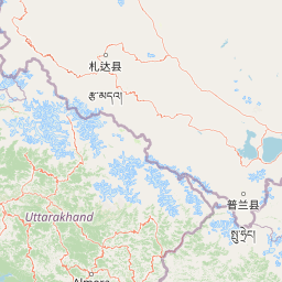
Map view of Jim Corbett National Park

Use this park location map to pinpoint Jim Corbett National Park in India, understand its exact geographic position, and read its mapped placement within the surrounding landscape more clearly.

Pigeon | © OpenStreetMap contributors

Location context for Jim Corbett National Park

Nainital districtUttarakhand
Park atlas

Compare diverse protected landscapes, mountain foothills, and riverine habitats across the surrounding Doon Valley region.

Explore National Parks and Protected Areas Near Jim Corbett National Park in India
Discover national parks and protected areas located geographically near Jim Corbett National Park, exploring interconnected conservation landscapes across India's sub-Himalayan belt. Compare diverse forest types, riverine ecosystems, and wildlife habitats within the Doon Valley and adjacent protected regions to understand broader ecological context and regional park distribution.
National parkUttarakhand

Rajaji National Park: Uttarakhand National Park and Tiger Reserve Landscape

Sivalik Hills geography and protected area context

Rajaji National Park is a vital protected landscape situated in the Uttarakhand region of India, recognized as both a national park and a tiger reserve. Its territory spans across the Sivalik Hills, offering a diverse terrain characterized by deciduous forests and riparian ecosystems. The park's location along the Ganga river significantly influences its ecology, providing a unique geographic context for its protected status and wildlife significance.

Area
820.5 km²
Established
1983
IUCN
II
Relief
Highland
National parkUttarakhand

Nanda Devi National Park: High-Altitude Protected Landscape and Himalayan Geography

Explore mapped glacial basins and alpine terrain in Uttarakhand.

Nanda Devi National Park is a prime example of a high-altitude protected area, nestled in the Garhwal Himalayas of Uttarakhand, India. Established in 1982, this national park protects a vast glacial sanctuary, renowned for its dramatic peaks, including Nanda Devi, India's second-highest mountain. The park's landscape is defined by rugged terrain, extensive glaciers like the Uttari Rishi and Dakshini Rishi, and a striking ring of mountains over 6,000 meters, providing critical context for understanding protected land geography and Himalayan atlas exploration.

Area
630.33 km²
Established
1982
IUCN
II
Relief
Mountain
National parkChamoli district

Valley of Flowers National Park: National Park Protected Landscape and Geographic Context

Explore the mapped terrain and regional boundaries of this Himalayan national park.

Valley of Flowers National Park is a distinct protected area within India's Garhwal region, situated in the Chamoli district. This park detail page facilitates atlas-focused discovery, highlighting its mapped boundaries and geographic significance. Users can explore the protected landscape's role within its regional context, providing essential data for understanding its ecological and geographical importance for landscape exploration.

Area
87.5 km²
Established
1982
Relief
Mountain
Climate
Alpine
Watercolor scene of grassy fields and a winding river with distant hills and trees
National parkSudurpashchim Province

Shuklaphanta National Park: A National Park in Nepal's Sudurpashchim Province

Explore mapped protected areas and regional landscape context.

Shuklaphanta National Park is a key protected landscape within Sudurpashchim Province, Nepal. As a designated national park, its geographic identity is significant for understanding regional conservation and natural terrain. This entry focuses on its mapped boundaries and role as a protected area, providing foundational geographic context for atlas exploration and discovery of Nepal's natural landscapes.

Area
305 km²
Established
2017
IUCN
II
Relief
Lowland
National parkHaryana

Kalesar National Park: Exploring Haryana's Unique Sal Forest Protected Landscape

Discover mapped terrain and regional geography within the Shivalik foothills.

Kalesar National Park, located in the Shivalik foothills of Haryana, is a crucial protected area renowned for its natural sal forest, a rare ecological feature in the state. Spanning approximately 53 square kilometers, the park's diverse terrain offers insights into regional geography and conservation, serving as a vital habitat for leopards and a corridor for wild elephants. Its mapped boundaries encompass a unique landscape that contrasts sharply with surrounding agricultural lands, making it a significant point of study for protected-area enthusiasts.

Area
53 km²
Established
2003
IUCN
IV
Relief
Highland
National parkNepal

Khaptad National Park: Nepal's National Park Landscape and Protected Area Geography

Explore the mapped terrain and regional context of this protected landscape.

Khaptad National Park is a designated national park in Nepal, offering a unique entry point for exploring protected landscapes and regional geography. This entry details the park's mapped boundaries and its significance within the broader atlas of natural terrain. Users can delve into the specific geographic context of this protected area, understanding its role within Nepal and the wider South Asian context for structured landscape discovery.

Area
225 km²
Established
1984
IUCN
II
Relief
Mountain
National parkLakhimpur Kheri district

Dudhwa National Park: Terai Grasslands and Alluvial Plain Geography within Lakhimpur Kheri

Discover the mapped protected landscape of this vital Indian national park.

Dudhwa National Park in Lakhimpur Kheri district stands as a crucial example of the Terai grassland ecosystem, characterized by its expansive alluvial plains and marshy habitats. This page provides an atlas-style exploration of its protected landscape, detailing the unique terrain and geographic context essential for understanding its conservation significance.

Area
614 km²
Established
1977
IUCN
II
Visitors
26K annual
National parkHaryana

Sultanpur National Park: Haryana's Designated Protected Landscape and Atlas Context

Mapped boundaries and regional geographic significance.

Delve into Sultanpur National Park, an important protected area within Haryana, India, viewed through an atlas and map-driven lens. This entry details the park's designation as a national park, offering insights into its specific geographic footprint and its relation to the surrounding regional terrain. Understand how Sultanpur National Park contributes to the protected landscape mosaic of North India, providing critical data for those exploring India's geography and conservation areas.

Area
1.43 km²
Established
1991
IUCN
II
Relief
Lowland

Common questions about visiting, size, designation, and location context for Jim Corbett National Park

Jim Corbett National Park FAQs for park facts, access, geography, and protected area context
Find quick answers about Jim Corbett National Park, including protected-area facts, park geography, trail and visitor context, and how the park fits into its surrounding country and regional landscape.
MoriAtlas Explorer

Continue Your Protected Areas Search Across the Global Atlas

Deepen your exploration by continuing the structured search for national parks and protected areas worldwide. Utilize the comprehensive filtering capabilities to compare different conservation landscapes and refine your understanding of global park geography. Discover more about the distribution and characteristics of protected natural areas.

Global natural geography