
Islands
Park geography
A comprehensive analysis of landscape features, subpolar climates, and island geography
Kawésqar National Park Detailed Geography, Regional Boundaries, and Physical Terrain Profile
Kawésqar National Park encompasses a vast, complex landscape across the Magallanes and Chilean Antártica Region. This geography profile details the physical boundaries, mixed relief, and diverse habitat classifications, ranging from coastal islands to temperate broadleaf forests and tundra environments.
Related tags
Magellanic rainforestPatagonian archipelagoIndigenous heritageTemperate forest wildernessGlacial landscapes
Patagonian archipelago wilderness of Magellanic rainforests and ancient Kawésqar heritage
Kawésqar National Park
Kawésqar National Park is a vast protected wilderness area in the southernmost region of Chile, spanning the archipelagic landscape on both sides of the Strait of Magellan. Formerly known as Alacalufes National Reserve, it is the second largest national park in Chile and ranks among the largest protected areas in the world, encompassing approximately 7 million acres of remote Patagonian terrain. The park is characterized by a labyrinth of islands, islets, channels, and fjords that make up the western archipelago region of Magallanes. Its ecological identity is defined by the Magellanic rainforest, a unique temperate forest ecosystem that thrives in the cool, humid conditions of this southern latitude. The park holds deep cultural significance as it preserves the ancestral lands of the Kawésqar people, also known as the Alacaluf, who inhabited these islands for approximately seven thousand years as nomadic hunter-gatherers.
- Location
- Chile
- Park type
- National park
- Established
- 1969
- Area
- 28,425.3 km²
Location overview
Coastal, island, and marine zones across Magallanes provinces
Geographic Profile of Kawésqar National Park in Chile
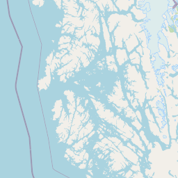
Kawésqar National Park lies in Chile within the Última Esperanza Province, Magallanes Province, and Magallanes and Chilean Antártica Region. Official records define its territory as an island, coastal, and marine park.
- Countries
- Chile
- Regions
- Magallanes and Chilean Antártica Region, Magallanes Province, Última Esperanza Province
- Primary location
- Magallanes and Chilean Antártica Region
- Geographic setting
- Coastal · Island · Marine
Boundary and coordinates
Visualizing the total area, coordinate limits, and spatial reach of the park
Geographic Boundary Map and Spatial Extent of Kawésqar National Park
Interactive boundary maps provide essential spatial context for the remote layout of Kawésqar National Park. Derived measurements display estimated area coverage alongside recorded center coordinates and geographic spans.
- Boundary area
- 55,363.9 km²
- Boundary perimeter
- 1,865.5 km
- Northernmost point
- 50.2019° S
- Southernmost point
- 54.3866° S
- Easternmost point
- 71.5869° W
- Westernmost point
- 75.5803° W
- Geographic centre
- 52.4563° S, 73.769° W
- North–south span
- 465.6 km
- East–west span
- 272.4 km
Terrain and natural features
Mapped physical geography featuring mixed relief and named island entities
Kawésqar National Park Terrain Classification and Recorded Island Features
Recorded terrain classifications outline mixed relief categories across the protected landscape. Associated feature cards detail names, types, and spatial relationships for islands located within boundaries.
Selected named natural features
Islands
Isla Christie
Islands
Islote Macizo
Islands
Isla Solar
Bays
Caleta Buena
Islands
Isla Astorga
Environmental setting
Subpolar climate zones, marine coastal habitats, and dominant forest cover.
Kawésqar National Park Environmental Settings and Landscape Classifications
Recorded habitat types and landscape features outline the physical setting across mixed relief terrains. Stored environmental categories link directly to relevant atlas destinations.
- Relief
- Mixed relief
- Climate
- Subpolar
- Water
- Water-dominated
- Forest cover
- Dense forest cover
Landscape features
Islands · Hills · Valleys · Coast · Forest · Tundra
Habitat types
Temperate broadleaf forest · Tundra habitat · Marine habitat · Coastal habitat
Park atlas
Expand your park discovery from Kawésqar National Park to other protected landscapes and national parks across the Southern Chile archipelago.
Discover Other National Parks and Protected Areas Near Kawésqar National Park
Continue your exploration from Kawésqar National Park by browsing other national parks and protected areas across Chile's remote Patagonian archipelago. Discover how nearby conservation landscapes connect to the unique Magellanic rainforest ecosystem and vast glacial fjords, gaining broader regional geographic context.
National parkMagallanes Region
Park boundaries overlap#1 closest
Southeast

Alberto de Agostini National Park: Glacial Landscapes and Cordillera Darwin Geography
Explore a protected national park in Chile's Magallanes Region.
Alberto de Agostini National Park is a significant protected area within the Magallanes Region, defined by the dramatic southern extent of the Andes, including the iconic Cordillera Darwin. This national park is characterized by extensive tidewater glaciers, deep fjords, and unique subpolar forests, offering a profound example of glacial landscape formation. Understanding its geographic setting and mapped boundaries provides critical context for exploring this remote Patagonian wilderness and its ecological significance.
- Area
- 14,600 km²
- Established
- 1965
- IUCN
- II
- Relief
- Mountain
National parkAysén del General Carlos Ibáñez del Campo Region
Park boundaries overlap#2 closest
North
Bernardo O'Higgins National Park: Southern Patagonian Ice Field & Glacial Terrain
Chile's largest protected area: a map of vast ice caps and fjords.
Bernardo O'Higgins National Park is a colossal protected landscape in Chile, safeguarding much of the Southern Patagonian Ice Field and its colossal glacial features like the Pío XI Glacier. Explore the dramatic terrain of towering granite peaks and intricate fjord systems that define this remote national park. This page provides essential context for understanding its geography, mapped boundaries, and significance as a vast wilderness preservation.
- Area
- 35,259 km²
- Established
- 1969
- IUCN
- II
- Visitors
- 36K annual
National parkMagallanes Region
27 km away#3 closest
Northeast
Torres del Paine National Park: National Park Protected Area Geography
Explore mapped protected landscapes and regional context.
Torres del Paine National Park represents a distinct protected landscape within Chile's Magallanes Region, offering valuable insights for geographic discovery and atlas exploration. This national park's mapped boundaries and unique terrain contribute to a comprehensive understanding of its protected status and environmental context. MoriAtlas provides structured data to explore the park's geography, landscape features, and its role as a vital protected natural area for detailed study.
- Area
- 1,814.14 km²
- Established
- 1959
- IUCN
- II
- Visitors
- 304.9K annual
National parkArgentina
60 km away#4 closest
North

Los Glaciares National Park: Argentinian National Park with Patagonian Ice Fields
Explore glacial terrain and iconic Andes peaks.
Los Glaciares National Park is a vast protected area in Argentina, dominated by a massive Patagonian ice cap and numerous descending glaciers, including the renowned Perito Moreno Glacier. Its dramatic landscape of ice fields, glacial lakes, and towering granite spires like Mount Fitz Roy provides critical context for understanding regional geography and the formation of glacial terrain. This park exemplifies the unique protected ecosystems of the southern Andes, offering rich detail for atlas-based discovery.
- Area
- 7,269.27 km²
- Established
- 1937
- IUCN
- II
- Visitors
- 688.8K annual
National parkMagallanes y la Antártica Chilena Region
73 km away#5 closest
South
Diego Ramírez Islands and Drake Passage National Park: A Southern Ocean Protected Landscape
Explore its remote island geography and vital Drake Passage marine ecosystems.
This national park protects one of the world's most remote and ecologically significant subantarctic environments, safeguarding the Diego Ramírez Islands and the legendary Drake Passage. It covers over 14 million hectares, representing Chile's southernmost contribution to global marine conservation and protecting unique pelagic bird habitats, marine mammal feeding grounds, and distinctive submarine geomorphology including Sars Seamount. The park's landscape is characterized by harsh subantarctic conditions, with vegetation adapted to cold, windy environments, and unique seafloor terrain beneath the powerful Antarctic Circumpolar Current.
- Area
- 144,391 km²
- Established
- 2025
- IUCN
- II
- Climate
- Subpolar
National parkTierra del Fuego
150 km away#6 closest
Southeast
Yendegaia National Park: A Chilean Protected Landscape within Tierra del Fuego
Mapped geographic context and protected area discovery.
Yendegaia National Park in Tierra del Fuego, Chile, stands as a distinct protected area offering valuable insights into regional geography and landscape. This page serves as a focused entry point for understanding the park's mapped boundaries and its significance as a national park. Delve into the specific geography and protected natural landscape that defines Yendegaia National Park within the broader South American atlas context.
- Area
- 1,506.12 km²
- Established
- 2013
- IUCN
- II
- Relief
- Mountain
National parkChile
166 km away#7 closest
East
Pali-Aike National Park: Chilean Protected Area and Landscape Atlas
Explore the geographic context and park boundaries in Chile.
Examine Pali-Aike National Park as a distinct protected landscape within Chile. This entry offers a detailed atlas perspective, focusing on its mapped boundaries, regional geographic setting, and the specific character of its natural terrain. Understand its significance as a national park and a point of interest for geographic discovery.
- Area
- 50.3 km²
- Established
- 1970
- IUCN
- II
- Visitors
- 2.5K annual
National parkArgentina
194 km away#8 closest
Southeast
Tierra del Fuego National Park: Southernmost Argentinian National Park and Protected Landscape
Explore the mapped terrain and subantarctic geography of this vital protected area.
Tierra del Fuego National Park, located at the southern tip of South America, provides a crucial atlas perspective on subantarctic ecosystems. This protected national park encompasses dramatic glacial valleys, rugged mountain ranges, ancient beech forests, and a significant coastal area along the Beagle Channel. Its unique landscape, accessible from Ushuaia, offers rich opportunities for understanding regional geography and the distribution of protected lands at the continent's edge.
- Area
- 630 km²
- Established
- 1960
- IUCN
- II
- Relief
- Mountain
MoriAtlas Explorer
Continue Exploring Kawésqar National Park's Geographic and Protected Landscape
Deepen your understanding of Kawésqar National Park by examining its mapped protected area and regional geographic placement. This dedicated exploration helps situate the park within its natural landscape context and highlights its importance as a national park for atlas-based discovery. Gain a clearer picture of the park's unique protected identity and its place in the broader atlas.
Browse next
Global natural geography
Explore related park routes
Explore MoriAtlas Global ParksBrowse All MoriAtlas ParksGlobal Park Map DiscoveryMoriAtlas: Browse All CountriesBrowse All MoriAtlas ContinentsNational Park Environment AtlasGrand Canyon National Park AtlasYellowstone National Park AtlasYosemite National Park Atlas and GeographySerengeti National Park AtlasGalápagos National Park Protected LandscapeBanff National Park Geography and AtlasKruger National Park Atlas EntryUluṟu-Kata Tjuṯa National Park AtlasExplore Uluru-Kata Tjuta National Park GeographyPlitvice Lakes National Park AtlasFiordland National Park Protected LandscapeGreat Smoky Mountains National Park AtlasAfghanistan National Parks and Protected AreasAlbania National Parks and Protected AreasAlgeria National Parks and Protected AreasAmerican Samoa National Parks and Protected AreasAndorra National Parks and Protected AreasAngola National Parks and Protected AreasAntarctica National Parks and Protected AreasAntigua and Barbuda Park List