Mori Atlas logo
National parkKazbegi National Park

Discover the mapped boundaries and alpine terrain of this prominent protected area in Mtskheta-Mtianeti.

Kazbegi National Park: A Protected Landscape in Georgia's Greater Caucasus Mountains

Kazbegi National Park represents a significant protected landscape within the Mtskheta-Mtianeti region of northeastern Georgia, anchoring the southern slopes of the Greater Caucasus. This national park preserves a rugged alpine terrain, characterized by towering peaks, deep river valleys, and high-altitude ecosystems that span from approximately 1,400 meters to over 3,000 meters. Through MoriAtlas, users can explore the park's geographic context, mapped boundaries, and unique natural features that define this vital section of the Caucasus.

mountain parksalpine ecosystemsprotected forestsGreater Caucasusendemic specieswildlife conservation

Kazbegi National Park

National park

Park overview

Structured park overview, official facts, and landscape profile for Kazbegi National Park

Kazbegi National Park park facts, protected area profile, and essential visitor context
Review the core facts for Kazbegi National Park, including designation, size, terrain, visitor scale, habitats, and operating context in one park-focused overview.

About Kazbegi National Park

Kazbegi National Park occupies a remarkable position in the Greater Caucasus mountain system, protecting a stretch of terrain that forms the natural boundary between Europe and Asia. The park's boundaries encompass some of the most spectacular mountain landscapes in the South Caucasus, with peaks rising well above 3,000 meters and glacial valleys carving through the terrain. The area has been inhabited for millennia, with evidence of human presence visible in the numerous historic churches, monasteries, and defensive structures scattered throughout the landscape.

The park's establishment in 1976 as a state reserve marked the beginning of formal conservation efforts in this ecologically significant region. Following Georgia's independence in 1991, the protected area was reclassified as a national park under the country's Protected Areas Law. The park's current boundaries include not only the core protected zone but also several nature monuments: Sakhiatsali Rock, Abano Mineral Lake, and the Truso Travertines. A visitor center operates within the park, providing information and facilitating access for tourists exploring this mountainous region.

Despite its popularity as a tourist destination, the park has historically faced challenges related to infrastructure development. Visitors are drawn to the area for trekking, mountaineering, and cultural tourism, with the iconic Gergeti Trinity Church being one of the most photographed landmarks in Georgia. The region's significance extends beyond tourism to encompass scientific, ecological, and cultural values that make it a cornerstone of Georgia's protected area network.

Quick facts and research context for Kazbegi National Park

Kazbegi National Park is located in north-eastern Georgia within the Mtskheta-Mtianeti region, centered around the town of Stepantsminda. The protected area covers approximately 78,000 hectares of Greater Caucasus terrain, established originally as a state reserve in 1976 and later designated as a national park. The park encompasses the northern slopes of the Kavkasioni ridge and the historic Khevi region, featuring high-altitude landscapes with elevations starting around 1,400 meters. The area is managed by Georgia's Agency of Protected Areas and functions as both a conservation unit and a popular destination for mountain tourism in the Caucasus.

Park context

Deeper park guide and search-rich context for Kazbegi National Park

Kazbegi National Park history, landscape, wildlife, and travel context
Explore Kazbegi National Park through its history, landscape character, ecosystems, wildlife, conservation priorities, cultural context, and seasonal travel timing in a structured park guide built for atlas discovery and search intent.

Why Kazbegi National Park stands out

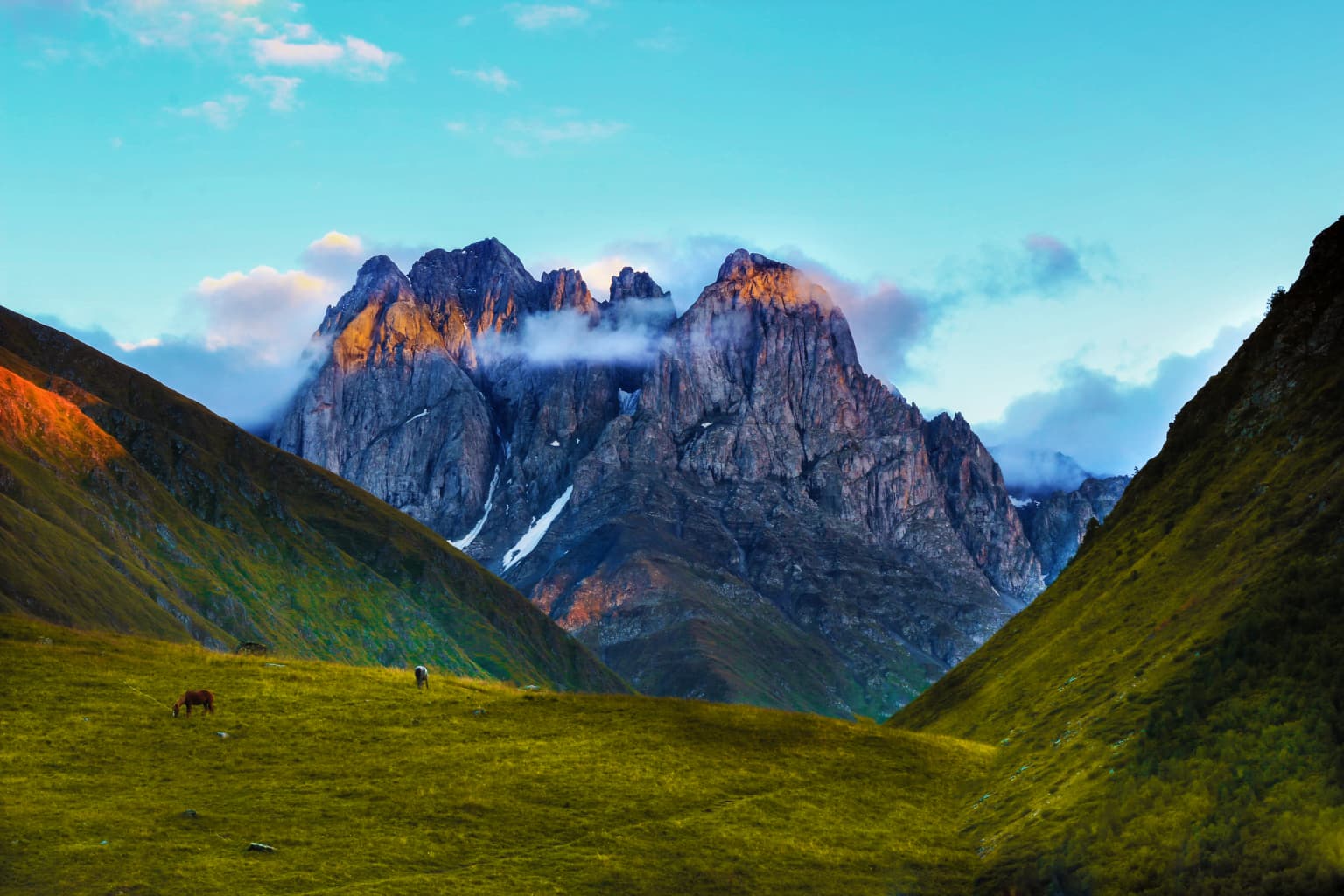
Kazbegi National Park is best known for its spectacular alpine scenery featuring the iconic Mount Kazbegi and the dramatic Gergeti Trinity Church perched on a hillside above the town. The park protects one of the Caucasus region's most significant high-altitude ecosystems, characterized by steep glacial valleys, alpine meadows, and rugged mountain terrain. It is renowned for supporting populations of East Caucasian tur and chamois, as well as being a stronghold for endemic Caucasian plant species. The combination of outstanding natural beauty with cultural landmarks like the Gergeti Church makes Kazbegi one of Georgia's most recognizable protected areas.

Kazbegi National Park history and protected-area timeline

Kazbegi National Park was originally established in 1976 as a state nature reserve, reflecting Georgia's commitment to conserving its mountainous landscapes even during the Soviet period. The protected area was created to preserve the unique ecosystems of the Greater Caucasus region and the outstanding natural landscapes of the Khevi historic region.

Following the restoration of Georgia's independence in 1991, the country's protected area framework underwent significant reorganization. Under Georgia's Protected Areas Law, Kazbegi was redesignated as a national park, granting it formal protection under the national park category. This transition reflected a broader shift toward establishing parks that could balance conservation with sustainable tourism and public access.

The modern protected area complex includes multiple designated zones: the core national park area of approximately 8,686 hectares, along with several recognized nature monuments covering additional territory. These include Sakhiatsali Rock, a notable geological feature; Abano Mineral Lake, a small but ecologically distinct water body; and the Truso Travertines, representing unique mineral deposition formations. The park is administered by the Agency of Protected Areas of Georgia, the national body responsible for managing the country's protected area network.

Kazbegi National Park landscape and geographic character

The landscape of Kazbegi National Park is defined by its position along the southern slopes of the Greater Caucasus main ridge, where towering mountain peaks give way to deep valleys and alpine terrain. The terrain is characteristically rugged, with steep-sided valleys carved by glacial activity and river erosion over millennia. The region's elevation range spans from approximately 1,400 meters at the valley floors to well over 3,000 meters at the highest peaks, creating diverse habitats across this vertical gradient.

Prominent features include dramatic rock faces and cliffs that define the dramatic scenery for which the region is famous. The landscape encompasses alpine meadows that bloom with wildflowers during the summer months, rocky terrain unsuitable for vegetation, and permanent snow fields on the highest summits. The Truso River valley and other watercourses have carved distinctive paths through the mountains, creating the characteristic valleys that define the Kazbegi area. The geological character of the region contributes to its visual drama, with the steep inclines and exposed rock creating the iconic Caucasus mountain scenery that attracts visitors from around the world.

Kazbegi National Park ecosystems, habitats, and plant life

Kazbegi National Park supports an ecologically significant mountain ecosystem characterized by remarkable plant diversity and distinctive habitat types. Approximately one-third of the park's territory is covered in forest, with the remaining areas comprising alpine meadows, snow-covered peaks, and inaccessible rocky terrain. The park documents approximately 1,347 plant species within its boundaries, representing one of the richest floral assemblages in the Caucasus region.

The forest communities are dominated by species adapted to the high-altitude environment, including Litvinov's birch, Caucasian pine, multiple juniper species, and sea buckthorn. These woodlands transition into alpine zones characterized by meadows and eventually into rocky terrain and permanent snow. Of particular conservation significance is the high degree of endemism, with over 26% of the plant species found in the park being endemic to the Caucasus region, meaning they occur nowhere else on Earth. This endemic character makes Kazbegi one of the most important centers of plant diversity in the entire Caucasus.

The park sits at the intersection of multiple ecological zones, creating a mosaic of habitats that supports diverse wildlife communities. The altitudinal range from subalpine forests through alpine meadows to nival zones creates distinct ecological bands, each supporting characteristic species assemblages.

Kazbegi National Park wildlife and species highlights

The fauna of Kazbegi National Park includes several species emblematic of the Caucasus mountain ecosystem. Among the most notable mammals is the East Caucasian tur, a wild goat species endemic to the eastern Caucasus that inhabits the rocky cliffs and steep terrain of the park. The chamois, another mountain goat-antelope, also occurs in the park's high-altitude zones. The brown bear remains present in the region, representing one of the larger predators within the park's ecosystem. Wolves maintain populations in the area, functioning as apex predators in the mountain ecosystem.

The birdlife of Kazbegi includes several species of conservation significance. The Caucasian snowcock inhabits the rocky alpine zones, while populations of griffon vulture and the bearded vulture, also known as lammergeier, are found in the park. The golden eagle, Georgia's national symbol, occurs as a breeding species in the high mountains. These raptor species are protected under Georgia's Red Book and represent the park's significance for avian conservation. Many of these wildlife species are listed in Georgia's Red Book of Endangered Species, reflecting their conservation importance and the critical role that Kazbegi plays in protecting them.

Kazbegi National Park conservation status and protection priorities

Kazbegi National Park serves as a critical conservation unit within Georgia's protected area network, preserving both outstanding natural landscapes and significant biodiversity. The park's designation as an IUCN Category II protected area reflects its primary objective of protecting natural ecosystems while allowing for sustainable public use. The high degree of plant endemism within the park's boundaries—exceeding 26% of documented species—makes it globally significant for biodiversity conservation.

The protected area provides essential habitat for species of conservation concern, including multiple species listed in Georgia's Red Book. The East Caucasian tur, chamois, wolf, brown bear, golden eagle, griffon vulture, and bearded vulture all receive protection within the park's boundaries. The presence of these species, particularly the large mammals and apex predators, indicates the ecological integrity of the park's ecosystems. The multiple nature monuments included within the protected area complex—Sakhiatsali Rock, Abano Mineral Lake, and the Truso Travertines—provide additional protection for specific geological and ecological features.

The park's management under the Agency of Protected Areas ensures that conservation objectives are integrated with sustainable tourism and visitor access, though challenges remain in developing appropriate infrastructure while maintaining ecological integrity.

Kazbegi National Park cultural meaning and human context

The Kazbegi region holds deep historical and cultural significance, situated in the historic Khevi region of Georgia. The landscape is marked by numerous religious monuments that reflect the area's role as a center of Georgian Christianity dating back centuries. The Gergeti Trinity Church, dating to the 14th century, stands as the most iconic landmark, perched on a hillside and framed by the dramatic Caucasus peaks. Additional historic structures include the Sioni basilica, Akhaltsikhe basilica, and the 17th-century Sno Castle.

The region also preserves evidence of pre-Christian traditions, with the area known for a blending of Christian and older pagan customs. This cultural layering reflects the historical position of Kazbegi as a frontier region where different traditions and influences intersected. The area's strategic importance along mountain routes passing through the Caucasus is evidenced by the numerous defensive structures and churches that mark the landscape. Local communities have maintained traditional land use practices in the surrounding areas, including pastoral activities that have shaped the cultural landscape over generations.

Top sights and standout views in Kazbegi National Park

Kazbegi National Park combines outstanding natural values with remarkable cultural heritage in one of the Caucasus region's most dramatic mountain settings. The park protects critical habitat for endemic species including over 26% of its plant species found nowhere else on Earth, while supporting populations of East Caucasian tur, chamois, and impressive raptor species. The iconic pairing of the Gergeti Trinity Church with the backdrop of Mount Kazbegi creates one of Georgia's most recognizable images. The high-altitude ecosystem, ranging from approximately 1,400 meters to over 3,000 meters, supports distinct ecological zones from subalpine forests through alpine meadows to rocky peaks. The park includes several nature monuments—Sakhiatsali Rock, Abano Mineral Lake, and Truso Travertines—adding geological and hydrological diversity to its conservation mandate.

Best time to visit Kazbegi National Park

Kazbegi National Park can be visited throughout the year, though the summer months from June through September typically offer the most accessible conditions for hiking and exploration. During this period, the alpine meadows are accessible, temperatures are moderate in the valleys, and the high mountain routes are snow-free. Autumn brings changing foliage colors to the forest areas and typically clear weather, though conditions begin to cool as the season progresses.

Winter transforms the landscape dramatically, with heavy snow cover creating conditions for winter sports and photography but making many trails inaccessible. The stark beauty of the snow-covered peaks is a significant attraction for winter visitors, though infrastructure limitations mean that access to the park requires appropriate preparation. Spring arrives later at these altitudes, with snow clearing from the lower trails in May and the first flowers appearing in the meadows. The shoulder seasons of late spring and autumn offer the advantages of fewer visitors while still providing access to the park's main attractions.

Park location guide

Geography guide, regional context, and park location map for Kazbegi National Park

Kazbegi National Park park geography, regions, and map view in Georgia
Understand where Kazbegi National Park sits in Georgia through a broader geographic reading of the surrounding landscape, nearby location context, and its mapped position within the national park landscape.

How Kazbegi National Park fits into Georgia

Georgia is a transcontinental country spanning Eastern Europe and West Asia, situated in the Caucasus region along the Black Sea. It declared independence from the Soviet Union in 1991 and today functions as a unitary parliamentary republic with Tbilisi as its capital. The nation is notable for its distinctive Georgian language, Orthodox Christian traditions dating to the 4th century, and archaeological evidence of the world's earliest winemaking sites.

Wider geography shaping Kazbegi National Park in Georgia

Georgia occupies a strategic position at the crossroads of Eastern Europe and West Asia, bordered by Russia to the north and northeast, the Black Sea to the west, Turkey and Armenia to the south, and Azerbaijan to the southeast. The terrain is predominantly mountainous in the north with the Greater Caucasus range, transitioning to plains and valleys in the east. The country spans approximately 69,700 square kilometres.

Map view of Kazbegi National Park

Use this park location map to pinpoint Kazbegi National Park in Georgia, understand its exact geographic position, and read its mapped placement within the surrounding landscape more clearly.

Pigeon | © OpenStreetMap contributors

Location context for Kazbegi National Park

Kazbegi MunicipalityMtskheta-Mtianeti
Park atlas

Map the surrounding high-altitude Caucasus terrain and related protected landscapes in Georgia and beyond.

Compare National Parks: Discover Protected Areas Adjacent to Kazbegi National Park
After exploring Kazbegi National Park, discover other protected areas and national parks throughout Georgia's Greater Caucasus region, tracing mountain landscapes and high-altitude ecosystems. Compare geographic features, conservation mandates, and regional park contexts to deepen your understanding of the Caucasus mountain environment.
Watercolor painting showing a landscape with green hills, trees, and distant mountains
National parkMtskheta-Mtianeti

Pshav-Khevsureti National Park: Protected Mountain Landscape and Regional Geography in Mtskheta-Mtianeti

Explore rugged terrain and alpine ecosystems in Georgia's Caucasus.

Pshav-Khevsureti National Park is a key protected area in Georgia's Mtskheta-Mtianeti region, recognized for its dramatic mountain terrain, deep river valleys, and alpine zones. Established as a national park, it safeguards the watersheds of major rivers, supporting significant wildlife and offering a compelling geographic context for atlas exploration. This protected landscape provides insight into the unique natural and cultural heritage of the Khevsureti region, making it a focal point for understanding Georgia's protected area network and mountainous geography.

Area
1,400.44 km²
Established
2014
IUCN
II
Relief
Mountain
National parkNorth Ossetia-Alania

Alaniya National Park: Protected Glacial Mountain Landscape in North Ossetia-Alania, Russia

Explore dramatic terrain and ancient heritage.

Alaniya National Park, situated in the rugged Central Caucasus Mountains of North Ossetia-Alania, Russia, is a premier example of a protected landscape defined by its dramatic glacial formations and high alpine environments. The park's geography features extensive glaciated peaks, deep valleys, and unique biodiversity. It preserves critical habitats and showcases significant archaeological sites, providing a rich context for understanding the natural and cultural history of the region through a structured atlas perspective.

Area
549 km²
Established
1998
IUCN
II
Relief
Mountain
Watercolor illustration of a landscape with mountains, a river, trees, and grassy fields
National parkMtskheta Municipality

Tbilisi National Park: Oldest Protected Landscape in Mtskheta Municipality

Explore Georgia's oldest national park and its mapped forest terrain.

Tbilisi National Park represents Georgia's oldest protected area, nestled in the Saguramo Range within Mtskheta Municipality. This page provides an atlas-focused view of its geographic features, including mountainous terrain and deciduous forest ecosystems. Users can explore the park's mapped boundaries and understand its significance as a crucial natural landscape close to Tbilisi, contributing to the region's protected areas network.

Area
380.02 km²
Established
1973
IUCN
II
Relief
Highland
National parkGeorgia

Tusheti National Park National Park: Geographic Exploration of Caucasus Protected Landscapes

Mapped protected area boundaries and alpine terrain in Georgia.

Tusheti National Park offers a deep dive into the rugged geography of the Greater Caucasus. This national park, situated in a remote corner of Georgia, protects a dramatic landscape characterized by high mountain ridges, glacial valleys, and diverse ecosystems. The park's mapped boundaries encompass significant alpine terrain, providing essential habitat and serving as a critical area for understanding regional protected land distribution and landscape context. Explore the unique geographic identity of Tusheti National Park.

Area
1,276.43 km²
Established
2003
IUCN
II
Relief
Mountain
Watercolor illustration of a mountainous landscape with green forests, rolling hills, and distant mountains under a light sky
National parkGeorgia

Algeti National Park: Explore Georgia's Protected Coniferous Forest Landscape

Mountain terrain, protected forests, and regional geography.

Algeti National Park, located in Georgia's Kvemo Kartli region, serves as a critical protected area preserving the easternmost populations of Caucasian Spruce and Nordmann Fir. This national park features a dramatic mountainous landscape within the Trialeti Range, characterized by deeply incised valleys, flowing rivers, and extensive old-growth forest ecosystems. Users can explore the park's geographic context, mapped boundaries, and the ecological significance of its unique coniferous and mixed forests, contributing to a broader understanding of protected lands in the Caucasus.

Area
68.22 km²
Established
2007
IUCN
II
Visitors
8K annual
National parkGeorgia

Borjomi-Kharagauli National Park: Protected Landscape Atlas of Georgia's Lesser Caucasus

Explore its unique forests, wildlife, and mountain terrain.

Delve into Borjomi-Kharagauli National Park, a significant protected area in Georgia's Lesser Caucasus region. This national park is renowned for its extensive old-growth forests, including rare Colchian fragments, and a remarkable concentration of endemic species. The park's dramatic mountainous terrain, spanning over 1,000 square kilometers, offers a rich tapestry of landscapes from deep valleys to alpine meadows, providing critical habitat for large mammals and contributing significantly to the region's biodiversity. Explore its mapped boundaries and geographic context for a deeper understanding of this vital conservation landscape.

Area
1,093 km²
Established
1995
IUCN
II
Relief
Mountain
Watercolor painting of green and pink mountain ranges under a light sky background
National parkSamtskhe–Javakheti

Javakheti National Park: Protected Highland Landscape and Wetland Atlas

Explore the unique geography and mapped park boundaries of this Georgian protected area.

Delve into Javakheti National Park, a significant protected landscape located in Georgia's Samtskhe, Javakheti region. This page serves as an entry point for understanding the park's distinctive highland terrain, its remarkable chain of lakes and marshes, and its protected area status. Explore the geographic context of this national park, its role in wetland conservation, and its value for structured atlas-based discovery of natural landscapes.

Area
238.53 km²
Established
2011
IUCN
II
Relief
Mixed relief
National parkShirak Province

Lake Arpi National Park: High-Altitude Wetland Protected Landscape in Shirak Province

Mapped boundaries of an important South Caucasus conservation area.

Lake Arpi National Park offers a unique window into high-altitude wetland ecosystems on the Shirak and Javakheti plateau, located at roughly 2000 meters above sea level. Established as a national park in 2009, it protects critical habitats, including the central Lake Arpi, and serves as a vital sanctuary for numerous bird species. This protected area is distinguished by its alpine meadows, significant bird populations, and its distinct geographic setting within Armenia's northwestern region, providing rich context for atlas-based exploration of protected lands.

Area
250 km²
Established
2009
IUCN
II
Relief
Mountain

Common questions about visiting, size, designation, and location context for Kazbegi National Park

Kazbegi National Park FAQs for park facts, access, geography, and protected area context
Find quick answers about Kazbegi National Park, including protected-area facts, park geography, trail and visitor context, and how the park fits into its surrounding country and regional landscape.
MoriAtlas Explorer

Continue Your Protected Areas Search Across the Global Atlas

Deepen your exploration by continuing the structured search for national parks and protected areas worldwide. Utilize the comprehensive filtering capabilities to compare different conservation landscapes and refine your understanding of global park geography. Discover more about the distribution and characteristics of protected natural areas.

Global natural geography