Mori Atlas logo
National parkKhao Khitchakut National Park

Understand the mapped boundaries and regional natural landscape of this significant national park.

Khao Khitchakut National Park: Protected Landscape and Geographic Context in Thailand

Khao Khitchakut National Park represents a vital protected natural area within the broader geography of Thailand. This page offers an atlas-style view, focusing on the park's specific geographic setting and its established protected boundaries. Users can explore the mapped extent of Khao Khitchakut National Park, gaining insight into its contribution to Thailand's conservation landscapes and regional natural terrain.

National ParksThailandMountain ForestsWaterfallsBuddhist Sacred SitesCardamom Mountains

Khao Khitchakut National Park

National park

Park overview

Structured park overview, official facts, and landscape profile for Khao Khitchakut National Park

Khao Khitchakut National Park park facts, protected area profile, and essential visitor context
Review the core facts for Khao Khitchakut National Park, including designation, size, terrain, visitor scale, habitats, and operating context in one park-focused overview.

About Khao Khitchakut National Park

Khao Khitchakut National Park represents a unique blend of ecological preservation and cultural significance within Thailand's protected area system. Established in 1977 as the 14th national park in Thailand, the park occupies a mountainous portion of the Soi Dao Mountains in Chanthaburi Province, part of the broader Cardamom Mountains that stretch across southeastern Thailand and into Cambodia. The park's relatively compact size of 59 square kilometres makes it one of Thailand's smaller national parks, yet it maintains substantial ecological value through its forest coverage and biodiversity. The landscape is dominated by mountainous terrain with the prominent Khao Phra Bat peak serving as both a natural and spiritual landmark. Beyond its natural attributes, the park holds deep religious significance for Thai Buddhists, with the Buddha footprint at Khao Phra Bat representing a sacred site that has drawn pilgrims for generations. This combination of ecological and cultural importance creates a distinctive character for the park within Thailand's national park network.

Quick facts and research context for Khao Khitchakut National Park

Khao Khitchakut National Park spans 59 square kilometres in Chanthaburi Province, located roughly 28 kilometres northeast of Chanthaburi town. The park was established in 1977 and is managed by Thailand's Department of National Parks, Wildlife and Plant Conservation. Its terrain is characterized by mountainous forest landscapes within the Soi Dao Mountains, with the highest point at Khao Phra Bat peak. The park borders the larger Khao Soi Dao Wildlife Sanctuary, creating a contiguous protected zone. It is notable for both its ecological diversity and its religious significance, featuring a sacred Buddha footprint site that attracts Buddhist pilgrims.

Park context

Deeper park guide and search-rich context for Khao Khitchakut National Park

Khao Khitchakut National Park history, landscape, wildlife, and travel context
Explore Khao Khitchakut National Park through its history, landscape character, ecosystems, wildlife, conservation priorities, cultural context, and seasonal travel timing in a structured park guide built for atlas discovery and search intent.

Why Khao Khitchakut National Park stands out

Khao Khitchakut is best known for two distinct qualities: its natural landscapes of forested mountains and waterfalls, and its sacred Buddhist site at Khao Phra Bat peak containing a revered Buddha footprint. The park's Krathing Falls, a 13-level waterfall system fed by the Chanthaburi River, is a major attraction for visitors. The mountain peak also features distinctive rock formations attributed with shapes resembling a pagoda, a monk's alms bowl, a turtle, and an elephant. During the Magha Puja holiday, large numbers of Thai Buddhists make pilgrimages to the Buddha footprint site, making this one of the country's more significant religious natural landmarks.

Khao Khitchakut National Park history and protected-area timeline

Khao Khitchakut National Park was officially designated as Thailand's 14th national park on 4 May 1977, marking a significant milestone in the country's early conservation efforts. The establishment of the park reflected Thailand's growing commitment to preserving its natural landscapes and biodiversity during the late 1970s, a period when the nation was systematically developing its national park system. The park was created to protect the forest ecosystems of the Soi Dao Mountains and the unique religious site at Khao Phra Bat. Management responsibilities fall to Thailand's Department of National Parks, Wildlife and Plant Conservation, which oversees both the ecological preservation and visitor services for the property. The park's designation also helped establish a connected protected zone alongside the adjacent Khao Soi Dao Wildlife Sanctuary, creating a larger conservation landscape in the region.

Khao Khitchakut National Park landscape and geographic character

The terrain of Khao Khitchakut National Park is characterized by mountainous forest landscapes within the Soi Dao Mountains. The park's highest point reaches 1,085 metres at Khao Phra Bat peak, which dominates the western portion of the protected area. The mountainous terrain features steep slopes and ridgelines typical of the Cardamom Mountains system, with valleys and drainage channels cutting through the forest. The Chanthaburi River and its tributaries flow through the park, feeding the waterfall systems that are among the park's most notable features. The Krathing waterfall system descends through 13 distinct levels, with nature trails intersecting the cascade at various points, creating a scenic and accessible attraction for visitors. Additional waterfalls include Changsay and Klong Piboon, further adding to the park's water-related landscape features. The combination of forested mountain slopes, prominent peaks, and waterfall systems creates a visually diverse landscape within the relatively small park boundary.

Khao Khitchakut National Park ecosystems, habitats, and plant life

The park's forest ecosystems represent significant ecological value within Thailand's eastern region. The vegetation includes several valuable timber species such as Dalbergia cochinchinensis, Pterocarpus macrocarpus, Afzelia xylocarpa, Dipterocarpus tuberculatus, Xylia xylocarpa, and Lagerstroemia calyculata. These species represent the typical composition of lowland and hill dipterocarp forests found throughout the Cardamom Mountains region. The forest coverage provides critical habitat for diverse wildlife species and contributes to watershed protection for the Chanthaburi River basin. The park's position within the broader Cardamom Mountains ecosystem connects it to one of Southeast Asia's most significant remaining forest areas, making it part of a larger ecological network that supports substantial biodiversity. The protected status helps preserve these forest communities from logging and conversion pressures that have affected much of the surrounding lowland areas.

Khao Khitchakut National Park wildlife and species highlights

Khao Khitchakut National Park supports several notable mammal species within its forest habitats. Large mammals present in the park include gaur, Asiatic black bear, sambar deer, and serow, representing some of the region's more significant terrestrial megafauna. Wild elephant herds have also been recorded within the park, though their movements likely extend between protected areas. Smaller mammal species include the northern red muntjac, which is commonly encountered in forest edge areas. The bird diversity includes species such as the Asian koel, blue-winged pitta, hooded pitta, and Oriental magpie-robin, representing both resident and potentially migratory species. The combination of forest habitats at varying elevations supports this diversity of wildlife, though the park's relatively small size means that larger species may move between the protected area and adjacent habitats including the Khao Soi Dao Wildlife Sanctuary.

Khao Khitchakut National Park conservation status and protection priorities

Khao Khitchakut National Park contributes to Thailand's conservation framework as an IUCN Category II protected area, representing national park status that emphasizes both ecosystem protection and sustainable recreation. The park forms part of a larger conservation landscape when combined with the adjacent Khao Soi Dao Wildlife Sanctuary, creating a more extensive protected zone that supports wildlife movement and ecological processes. The protected status helps preserve the forest ecosystems of the Soi Dao Mountains, which represent a significant remnant of the original forest cover that once dominated eastern Thailand. The protection of the Buddha footprint site also provides an additional layer of cultural preservation, as the religious significance ensures ongoing stewardship by local communities. The park's relatively small size presents both challenges and opportunities, requiring careful management to balance visitor use with ecological preservation.

Khao Khitchakut National Park cultural meaning and human context

Khao Khitchakut holds profound significance within Thai Buddhist tradition due to the presence of a sacred Buddha footprint at Khao Phra Bat peak. This religious site is one of the few natural Buddha footprint locations in Thailand and attracts significant pilgrimages, particularly during the Magha Puja holiday in February or March. The pilgrimage tradition connects the natural landscape with spiritual practice, making the park a place where ecological and cultural values intersect. The rock formations at Khao Phra Bat peak have also acquired traditional attributions, with local interpretation assigning the shapes of a pagoda, a monk's alms bowl, a turtle, and an elephant to various rock features. This cultural layer adds depth to the park's identity beyond its purely ecological significance, reflecting how natural landscapes in Thailand have historically been incorporated into religious and spiritual practice.

Top sights and standout views in Khao Khitchakut National Park

Khao Khitchakut National Park offers visitors a combination of natural and cultural attractions within a relatively accessible mountain setting. The Buddha footprint site at Khao Phra Bat peak represents the park's most significant cultural feature, drawing Buddhist pilgrims and curious visitors alike. Krathing Falls, with its 13-level cascade system, provides a scenic natural attraction that can be explored via nature trails that intersect the waterfall at multiple points. The mountain trails leading to Khao Phra Bat reward hikers with both panoramic views and the opportunity to visit the sacred footprint site, while the surrounding forest areas offer chances to observe wildlife and experience the park's ecological character. The park's proximity to Chanthaburi town makes it a feasible day-trip destination while still providing a meaningful natural retreat.

Best time to visit Khao Khitchakut National Park

The optimal time to visit Khao Khitchakut National Park coincides with the cool dry season from November through February, when temperatures are more comfortable for hiking and the forest environment is typically less humid. However, the park holds particular significance during the Magha Puja holiday, typically falling in February or March, when thousands of Buddhist pilgrims ascend to the Buddha footprint site at Khao Phra Bat. Visitors seeking a quieter experience may prefer to avoid this major pilgrimage period, while those interested in witnessing the traditional ceremonies may plan their visit accordingly. The wet season from May to October brings increased rainfall that can affect trail conditions and accessibility, though the waterfalls typically flow more strongly during and after the rainy period.
Park location guide

Geography guide, regional context, and park location map for Khao Khitchakut National Park

Khao Khitchakut National Park park geography, regions, and map view in Thailand
Understand where Khao Khitchakut National Park sits in Thailand through a broader geographic reading of the surrounding landscape, nearby location context, and its mapped position within the national park landscape.

How Khao Khitchakut National Park fits into Thailand

Thailand is a Southeast Asian nation formerly called Siam, located in mainland Southeast Asia. It operates as a unitary parliamentary constitutional monarchy under King Vajiralongkorn. The country borders Myanmar, Laos, Cambodia, and Malaysia, with maritime boundaries involving Vietnam, Indonesia, and India. Thailand has a population of nearly 66 million and covers approximately 513,120 km². Historically, the Sukhothai Kingdom marks the beginning of Thai history, followed by the powerful Ayutthaya Kingdom.

Wider geography shaping Khao Khitchakut National Park in Thailand

Thailand occupies mainland Southeast Asia with borders to Myanmar (west/northwest), Laos (east/northeast), Cambodia (southeast), and Malaysia (south). The country has coastline along the Gulf of Thailand to the southeast and the Andaman Sea to the southwest. The territory covers approximately 513,120 km².

Map view of Khao Khitchakut National Park

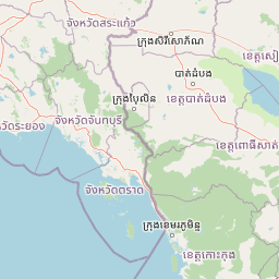
Use this park location map to pinpoint Khao Khitchakut National Park in Thailand, understand its exact geographic position, and read its mapped placement within the surrounding landscape more clearly.

Pigeon | © OpenStreetMap contributors

Location context for Khao Khitchakut National Park

Chanthaburi Province
Park atlas

Trace the regional geography and discover other protected landscapes across Eastern Thailand, extending your exploration beyond Khao Khitchakut.

Explore Nearby National Parks and Protected Areas Around Khao Khitchakut National Park
Browse a curated list of national parks and protected areas near Khao Khitchakut National Park, encompassing the mountain forests and unique landscapes of Eastern Thailand. This atlas view offers valuable geographic context for comparing diverse conservation efforts and tracing ecological connections across the wider Cardamom Mountains region.
National parkChanthaburi Province

Namtok Phlio National Park: A Protected Landscape in Chanthaburi Province

Explore National Park geography and mapped boundaries.

Namtok Phlio National Park, designated as a national park, offers a distinct geographic focus within Chanthaburi Province. This entry supports structured exploration of its protected landscape identity, mapped terrain, and regional context. Understand its place within the broader atlas of Thailand's conservation areas through detailed geographic information designed for discovery.

Area
135 km²
Established
1975
IUCN
II
Visitors
671.4K annual
National parkRayong Province

Khao Chamao, Khao Wong National Park: Protected Area Atlas and Mountain Landscape Context

Rayong Province's vital national park with mapped terrain and waterfalls.

Delve into the geography of Khao Chamao, Khao Wong National Park, a designated national park in Thailand's Rayong Province, forming a western extension of the Cardamom Mountains. This page provides detailed mapped context for its protected boundaries, forested hills, and prominent peaks, highlighting its importance as a habitat and an atlas entry for understanding regional landscapes. Explore the park's terrain and its role in conservation.

Area
84 km²
Established
1975
IUCN
II
Visitors
218.4K annual
Watercolor painting showing green hills, purple mountains, and a calm water body with sparse vegetation
National parkRayong Province

Khao Laem Ya, Mu Ko Samet National Park: Marine National Park and Protected Island Geography

Coastal terrain and archipelago mapped within Rayong Province.

Delve into Khao Laem Ya, Mu Ko Samet National Park, a significant marine protected area located in Rayong Province, Thailand. This atlas entry highlights the park's archipelago of islands, including Ko Samet, its mainland coastal features like Khao Laem Ya, and the surrounding Gulf of Thailand waters. Understand the park's role in coastal conservation, its mapped marine environments, and its unique blend of terrestrial and aquatic protected landscapes for geographic discovery.

Area
131 km²
Established
1981
IUCN
II
Visitors
1.6M annual
Watercolor landscape showing rolling hills, mountains, and a body of water with trees and vegetation
National parkThailand

Mu Ko Chang National Park: Thailand's National Park Landscape and Protected Area Geography

Mapped boundaries and regional context for this Thai national park.

Delve into the geography of Mu Ko Chang National Park, a vital national park located in Thailand. This page provides an atlas-level view of its protected area status, mapped boundaries, and its significance within the broader landscape of Southeast Asia. Understand the park's unique role as a conserved natural region through structured geographic data and detailed landscape context.

Area
650 km²
Established
1982
IUCN
II
Visitors
249.9K annual
National parkSa Kaeo Province

Pang Sida National Park: Protected Landscape Atlas in Sa Kaeo Province

Discover its mapped terrain and wildlife habitats.

Pang Sida National Park is a significant protected national park located in Sa Kaeo Province, Thailand, spanning approximately 844 square kilometers of the Sankamphaeng Range. As a critical element of the UNESCO Dong Phayayen-Khao Yai Forest Complex, it provides a vital protected landscape for diverse ecosystems and remarkable biodiversity. Users can explore the park's mountainous terrain, grasslands, and riparian zones, gaining insight into its geographic significance and its role within a larger conservation area.

Area
844 km²
Established
1982
IUCN
II
Visitors
58.4K annual
Watercolor painting showing green hills, pinkish mountains, and two trees in a scenic landscape
National parkSa Kaeo Province

Ta Phraya National Park: National Park & Protected Landscape Geography in Sa Kaeo Province

Explore the mapped boundaries and regional terrain of this Thai national park.

Ta Phraya National Park stands as a protected national park within the dynamic geography of Sa Kaeo Province, Thailand. This page offers an atlas-centric view, detailing the park's specific geographic footprint and its contribution to the regional landscape. Understanding Ta Phraya National Park's position, its mapped natural terrain, and its designation as a protected area is crucial for grasping Thailand's broader conservation geography.

Area
594 km²
Established
1996
IUCN
II
National parkThailand

Thap Lan National Park: Mapping Thailand's Protected Landscape Identity

Explore the mapped geography and protected area context.

Thap Lan National Park represents a vital element of Thailand's network of protected lands. This page offers an atlas-focused view of its geographic position and landscape character within the country. Users can uncover details about the park's mapped boundaries and its significance as a protected natural area. Understand its place in the broader context of Thai geography and conservation, enabling structured exploration of its natural terrain.

Area
2,236 km²
Established
1981
IUCN
II
Visitors
57.1K annual
National parkCambodia

Central Cardamom Mountains National Park: Cambodia's Premier Protected Rainforest Landscape

Explore Extensive Rainforest, Diverse Habitats, and Mountain Terrain

Central Cardamom Mountains National Park is Cambodia's largest protected area, a testament to significant rainforest conservation efforts. This national park spans approximately 4,010 square kilometers, showcasing a dynamic mountainous landscape with diverse ecological zones from coastal areas to peaks over 1,500 meters. Discover the geographic distribution of its protected boundaries and the rich tapestry of habitats that define this vital Southeast Asian natural reserve, offering deep context for atlas-based exploration.

Area
4,010.65 km²
Established
1999
IUCN
II
Relief
Mountain

Common questions about visiting, size, designation, and location context for Khao Khitchakut National Park

Khao Khitchakut National Park FAQs for park facts, access, geography, and protected area context
Find quick answers about Khao Khitchakut National Park, including protected-area facts, park geography, trail and visitor context, and how the park fits into its surrounding country and regional landscape.
MoriAtlas Explorer

Continue Your Protected Areas Search Across the Global Atlas

Deepen your exploration by continuing the structured search for national parks and protected areas worldwide. Utilize the comprehensive filtering capabilities to compare different conservation landscapes and refine your understanding of global park geography. Discover more about the distribution and characteristics of protected natural areas.

Global natural geography