Mori Atlas logo
National parkKhao Yai National Park

Understand the geographic setting and boundaries of this key national park in northeastern Thailand.

Khao Yai National Park: A Mapped Protected Landscape in Nakhon Ratchasima Province

Khao Yai National Park stands as a prominent protected area within Thailand's vast Nakhon Ratchasima Province, contributing significantly to the country's natural landscape. Situated in northeastern Thailand, this national park offers a unique opportunity for atlas-based exploration of its mapped boundaries and geographic context. Understanding Khao Yai National Park is key to appreciating the regional geography and the distribution of protected lands across the Khorat Plateau.

National ParkTropical ForestASEAN Heritage ParkUNESCO World Heritage SiteTiger ConservationWildlife Refuge

Khao Yai National Park

National park

Park overview

Structured park overview, official facts, and landscape profile for Khao Yai National Park

Khao Yai National Park park facts, protected area profile, and essential visitor context
Review the core facts for Khao Yai National Park, including designation, size, terrain, visitor scale, habitats, and operating context in one park-focused overview.

About Khao Yai National Park

Khao Yai National Park stands as Thailand's pioneering protected area and a cornerstone of the nation's conservation legacy. Situated approximately 150 kilometers northeast of Bangkok in the Dong Phaya Yen mountain range, the park encompasses a remarkable diversity of habitats ranging from lowland evergreen forests to montane forest zones. The establishment in 1962 marked a transformative moment in Thai environmental policy, driven substantially by the advocacy of Boonsong Lekagul, whose vision for wilderness preservation shaped the nation's approach to protected area management. The park's UNESCO World Heritage inscription in 2005 under the Dong Phayayen–Khao Yai Forest Complex designation reflects its exceptional ecological significance spanning multiple national parks within the same forest continuum. As adjacent lands face increasing development pressure from luxury hotels and golf courses, the park's ecological integrity faces ongoing challenges from encroachment and habitat fragmentation, making its conservation management increasingly complex.

Quick facts and research context for Khao Yai National Park

Khao Yai National Park spans roughly 2,166 square kilometers in central Thailand's Nakhon Ratchasima Province, protecting the Dong Phaya Yen mountain range's southern extent. The park features the distinctive spiral-shaped Khao Rom mountain at 1,351 meters elevation, the highest peak within the reserve. As Thailand's first national park, established in 1982, it holds ASEAN Heritage Park status since 1984 and became a UNESCO World Heritage Site in 2005. The climate follows three distinct seasons: a wet season from May through October, a cool dry season from November to February, and a hot season in March and April, with an annual mean temperature of 23°C. The park receives over 1.5 million visitors annually, making it one of Thailand's most visited protected areas.

Park context

Deeper park guide and search-rich context for Khao Yai National Park

Khao Yai National Park history, landscape, wildlife, and travel context
Explore Khao Yai National Park through its history, landscape character, ecosystems, wildlife, conservation priorities, cultural context, and seasonal travel timing in a structured park guide built for atlas discovery and search intent.

Why Khao Yai National Park stands out

Khao Yai National Park is renowned for its extensive old-growth evergreen forests, dramatic waterfalls including Haew Suwat, and its role as a critical tiger conservation landscape in Southeast Asia. The park represents one of the last remaining large-scale tropical forest ecosystems in mainland Thailand and serves as a vital ecological corridor connecting northern and southern forest complexes. Its significance is amplified by the 2016-2017 camera trap documentation of 18 tigers, including cubs, representing the first confirmed tiger presence in the park since 2002. The park also protects significant populations of Asian elephants, gibbons, and dhole wild dogs, making it a flagship for large-mammal conservation in the region.

Khao Yai National Park history and protected-area timeline

Khao Yai National Park was officially established on 18 September 1962 through royal proclamation published in the Government Gazette, becoming Thailand's inaugural national park. The park was named after the defunct tambon of Khao Yai, embedding local administrative heritage into its identity. Conservation pioneer Boonsong Lekagul was instrumental in advocating for the park's protection, recognizing the ecological value of the Dong Phaya Yen forest ecosystem before official establishment. In 1984, the park received ASEAN Heritage Park designation, acknowledging its regional significance within Southeast Asia's protected area network. The 2005 UNESCO World Heritage inscription elevated Khao Yai's global recognition, incorporating it into the Dong Phayayen–Khao Yai Forest Complex alongside adjacent protected areas. Contemporary challenges include managing visitor impacts, with annual attendance exceeding 1.5 million people, addressing illegal development within park boundaries, and combating unauthorized logging operations that threaten forest integrity.

Khao Yai National Park landscape and geographic character

The terrain of Khao Yai National Park features the prominent Dong Phaya Yen mountain range, characterized by steep ridges, deep valleys, and numerous perennial streams that have carved distinctive waterfalls throughout the landscape. Khao Rom stands as the park's highest summit at 1,351 meters, with its distinctive spiral form earning it the local name Khao Laem, meaning Spiky Mountain. The park's forest composition transitions from semi-evergreen forest in lower elevations through mixed deciduous zones to evergreen forest at higher altitudes, creating a complex ecological tapestry. Haew Suwat waterfall represents one of the most iconic landscapes within the park, where cascade waters drop through dense forest canopy. The Nong Pak Chee grassland area provides an unusual open habitat within the predominantly forested reserve, supporting different ecological communities. Hiking to major peaks requires substantial time, with ascents to Khao Rom requiring at least seven hours of walking and rope-assisted climbing near the summit.

Khao Yai National Park ecosystems, habitats, and plant life

Khao Yai National Park protects one of the most ecologically significant tropical forest ecosystems in mainland Southeast Asia. The park's forest types include semi-evergreen dipterocarp forest in lower elevations, mixed deciduous forest, and upper evergreen forest dominated by tall trees exceeding 45 meters in height with emergents rising above the canopy. These forests support extraordinary biodiversity, with the park serving as a critical corridor for species movement between northern and southern Thai forest complexes. The watershed function of these forests provides essential water resources for downstream communities and maintains hydrological cycles critical to regional ecology. The park's designation as part of the Dong Phayayen–Khao Yai World Heritage Site recognizes the forest ecosystem's outstanding universal value and its role in maintaining ecological processes essential for biodiversity persistence.

Khao Yai National Park wildlife and species highlights

The mammalian fauna of Khao Yai includes significant populations of large ungulates and carnivores that define the park's ecological character. Asian elephants traverse the forests in herds, while gibbons make their presence known through characteristic calls that echo through the canopy. Pig-tailed macaques, muntjacs, and sambar deer represent common ungulate species throughout the park's diverse habitats. Notable carnivore presence includes dhole wild dogs that hunt cooperatively in packs, along with occasional sun bear and Asian black bear sightings. The tiger population represents a particularly significant conservation achievement, with camera traps documenting 18 individuals including cubs in 2016-2017, the first confirmed tiger records since 2002. This tiger population restoration demonstrates the park's potential as a functioning large-mammal landscape when protection measures are effectively implemented. Smaller mammals include barking deer, porcupine, civet, and golden jackal, contributing to the park's overall mammalian diversity.

Khao Yai National Park conservation status and protection priorities

Khao Yai National Park occupies a critical position in Thailand's conservation strategy as the nation's first protected area and a model for subsequent national park establishment. Its ASEAN Heritage Park and UNESCO World Heritage designations reflect international recognition of its outstanding ecological value within Southeast Asia. The park's tiger population recovery demonstrates the effectiveness of sustained conservation investment, with the 2016-2017 camera trap confirmation of breeding activity representing a milestone for large carnivore conservation in Thailand. However, the park faces significant contemporary challenges including encroachment from illegal residential development, unauthorized logging operations, and the environmental impacts of high-volume visitation exceeding 1.5 million annual visitors. Management strategies have included innovative approaches such as mailing litter back to visitors who leave trash, addressing the substantial waste burden of over 23 tonnes generated during peak holiday periods. The challenge of acquiring additional land for wildlife conservation becomes increasingly difficult as surrounding areas develop, highlighting the tension between conservation goals and regional economic development pressures.

Khao Yai National Park cultural meaning and human context

While Khao Yai National Park is primarily valued for its ecological significance, the park exists within a landscape shaped by historical human activity in the broader Dong Phaya Yen region. The park's name derives from the former tambon administrative unit of Khao Yai, reflecting local geographic naming traditions. The surrounding communities in Nakhon Ratchasima Province maintain traditional relationships with the forested landscape, though the protected area designation has necessarily modified land-use patterns. The park's establishment in 1962 represented a modern conservation approach that sometimes conflicted with traditional practices, establishing a new paradigm for Thai wilderness preservation that prioritized ecological integrity over historical land-use patterns. The regional context includes nearby communities that have developed tourism-oriented economies serving the park's visitors, creating both economic opportunities and conservation pressures.

Top sights and standout views in Khao Yai National Park

Khao Yai National Park offers visitors access to some of Thailand's most impressive natural landscapes, including the iconic Haew Suwat waterfall featured in popular media. The opportunity to observe wild tigers, documented by camera trap studies confirming a resident population including cubs, represents a unique wildlife experience within Thailand's protected area network. The challenging hike to Khao Rom's summit rewards visitors with panoramic views from the park's highest point, though the seven-hour trek requires appropriate preparation. The cool season from November to February provides optimal conditions for hiking and wildlife observation, with clear skies and comfortable temperatures. The park's status as Thailand's first national park and a UNESCO World Heritage Site provides historical and cultural significance beyond its ecological value, making it a destination of national importance.

Best time to visit Khao Yai National Park

The optimal time to experience Khao Yai National Park is during the cool season from November through February, when daytime temperatures average around 22°C and nighttime temperatures drop to approximately 10°C, creating comfortable conditions for hiking and wildlife observation. Clear skies during this period provide excellent visibility for landscape photography and forest exploration. The rainy season from May to October transforms the landscape with lush vegetation and full-flowing streams, though heavy precipitation can restrict trail accessibility and create challenging conditions for visitors. The hot season in March and April brings higher temperatures ranging from 20-30°C, with reduced visibility in the forests as haze accumulates. For wildlife viewing, the dry season concentrations of animals around water sources can improve sighting opportunities, though the cool season provides the most pleasant overall experience for extended outdoor activities.

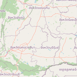
Park location guide

Geography guide, regional context, and park location map for Khao Yai National Park

Khao Yai National Park park geography, regions, and map view in Thailand
Understand where Khao Yai National Park sits in Thailand through a broader geographic reading of the surrounding landscape, nearby location context, and its mapped position within the national park landscape.

How Khao Yai National Park fits into Thailand

Thailand is a Southeast Asian nation formerly called Siam, located in mainland Southeast Asia. It operates as a unitary parliamentary constitutional monarchy under King Vajiralongkorn. The country borders Myanmar, Laos, Cambodia, and Malaysia, with maritime boundaries involving Vietnam, Indonesia, and India. Thailand has a population of nearly 66 million and covers approximately 513,120 km². Historically, the Sukhothai Kingdom marks the beginning of Thai history, followed by the powerful Ayutthaya Kingdom.

Wider geography shaping Khao Yai National Park in Thailand

Thailand occupies mainland Southeast Asia with borders to Myanmar (west/northwest), Laos (east/northeast), Cambodia (southeast), and Malaysia (south). The country has coastline along the Gulf of Thailand to the southeast and the Andaman Sea to the southwest. The territory covers approximately 513,120 km².

Map view of Khao Yai National Park

Use this park location map to pinpoint Khao Yai National Park in Thailand, understand its exact geographic position, and read its mapped placement within the surrounding landscape more clearly.

Pigeon | © OpenStreetMap contributors

Location context for Khao Yai National Park

Nakhon Ratchasima Province
Park atlas

Compare adjacent protected landscapes and explore the diverse ecosystems of the Dong Phaya Yen Mountains and central Thailand.

Discover National Parks and Protected Areas Near Khao Yai National Park
Continue your exploration from Khao Yai National Park by browsing other protected areas within the same regional context and surrounding landscapes. Comparing nearby national parks offers valuable insights into the broader geographic spread of conservation efforts across central Thailand, revealing connected forest complexes and diverse mountain ecosystems.
National parkSaraburi Province

Namtok Chet Sao Noi National Park: Protected Landscape and Seven-Tiered Waterfall Geography

Mapped terrain within Saraburi Province, Thailand.

Namtok Chet Sao Noi National Park offers a rich exploration of Thailand's natural geography, centered around its famous seven-tiered Chet Sao Noi waterfall. This national park, situated in Saraburi Province, features tropical rainforest ecosystems and distinctive landscapes within the Dong Phaya Yen mountains. Understand the park's mapped boundaries and its role as a vital protected area, providing insight into central Thailand's natural terrain and conservation efforts.

Area
42 km²
Established
2016
IUCN
II
Visitors
389.1K annual
National parkSaraburi Province

Namtok Sam Lan National Park: A Mapped Protected Landscape in Saraburi Province

Explore its terrain, waterfalls, and regional geography.

Gain detailed geographic insight into Namtok Sam Lan National Park, a vital protected area situated in Thailand's Saraburi Province. This destination provides a rich atlas view of its landscape, featuring prominent waterfalls and mixed forest ecosystems. Understand the park's specific location, mapped terrain, and its contribution to the regional geography, offering a concrete point for exploration.

Area
45 km²
Established
1981
IUCN
II
Visitors
45.8K annual
National parkThailand

Thap Lan National Park: Mapping Thailand's Protected Landscape Identity

Explore the mapped geography and protected area context.

Thap Lan National Park represents a vital element of Thailand's network of protected lands. This page offers an atlas-focused view of its geographic position and landscape character within the country. Users can uncover details about the park's mapped boundaries and its significance as a protected natural area. Understand its place in the broader context of Thai geography and conservation, enabling structured exploration of its natural terrain.

Area
2,236 km²
Established
1981
IUCN
II
Visitors
57.1K annual
National parkSa Kaeo Province

Pang Sida National Park: Protected Landscape Atlas in Sa Kaeo Province

Discover its mapped terrain and wildlife habitats.

Pang Sida National Park is a significant protected national park located in Sa Kaeo Province, Thailand, spanning approximately 844 square kilometers of the Sankamphaeng Range. As a critical element of the UNESCO Dong Phayayen-Khao Yai Forest Complex, it provides a vital protected landscape for diverse ecosystems and remarkable biodiversity. Users can explore the park's mountainous terrain, grasslands, and riparian zones, gaining insight into its geographic significance and its role within a larger conservation area.

Area
844 km²
Established
1982
IUCN
II
Visitors
58.4K annual
Watercolor painting showing green hills, pinkish mountains, and two trees in a scenic landscape
National parkSa Kaeo Province

Ta Phraya National Park: National Park & Protected Landscape Geography in Sa Kaeo Province

Explore the mapped boundaries and regional terrain of this Thai national park.

Ta Phraya National Park stands as a protected national park within the dynamic geography of Sa Kaeo Province, Thailand. This page offers an atlas-centric view, detailing the park's specific geographic footprint and its contribution to the regional landscape. Understanding Ta Phraya National Park's position, its mapped natural terrain, and its designation as a protected area is crucial for grasping Thailand's broader conservation geography.

Area
594 km²
Established
1996
IUCN
II
National parkChaiyaphum Province

Pa Hin Ngam National Park: Protected Area Atlas and Geographic Discovery in Chaiyaphum

Explore mapped boundaries and regional landscape context.

Pa Hin Ngam National Park is a significant national park entity located within Chaiyaphum Province, Thailand. This page offers detailed insight into its protected landscape, focusing on its mapped boundaries and how it fits into the regional geography of northeastern Thailand. Understand its identity as a conservation landscape through structured atlas exploration.

Area
100 km²
Established
1994
IUCN
II
Visitors
106.4K annual
National parkRayong Province

Khao Chamao, Khao Wong National Park: Protected Area Atlas and Mountain Landscape Context

Rayong Province's vital national park with mapped terrain and waterfalls.

Delve into the geography of Khao Chamao, Khao Wong National Park, a designated national park in Thailand's Rayong Province, forming a western extension of the Cardamom Mountains. This page provides detailed mapped context for its protected boundaries, forested hills, and prominent peaks, highlighting its importance as a habitat and an atlas entry for understanding regional landscapes. Explore the park's terrain and its role in conservation.

Area
84 km²
Established
1975
IUCN
II
Visitors
218.4K annual
National parkChaiyaphum Province

Sai Thong National Park: Protected National Park in Chaiyaphum Province's Geography

Explore mapped landscape and protected area context.

Sai Thong National Park is a designated national park located in Chaiyaphum Province, Thailand, contributing to the region's extensive network of protected areas. Its protected landscape identity is shaped by the geography of northeastern Thailand, offering a unique focus for map-based discovery and understanding the distribution of natural areas. Explore the mapped terrain and regional context of this significant natural landmark.

Area
319 km²
Established
1992
IUCN
II
Visitors
51.2K annual

Common questions about visiting, size, designation, and location context for Khao Yai National Park

Khao Yai National Park FAQs for park facts, access, geography, and protected area context
Find quick answers about Khao Yai National Park, including protected-area facts, park geography, trail and visitor context, and how the park fits into its surrounding country and regional landscape.
MoriAtlas Explorer

Continue Your Protected Areas Search Across the Global Atlas

Deepen your exploration by continuing the structured search for national parks and protected areas worldwide. Utilize the comprehensive filtering capabilities to compare different conservation landscapes and refine your understanding of global park geography. Discover more about the distribution and characteristics of protected natural areas.

Global natural geography