Mori Atlas logo
Nature reserveLa Trinité National Nature Reserve

Mapping the protected boundaries and natural terrain of this key French Guiana nature reserve.

La Trinité National Nature Reserve: Protected Landscape Identity in French Guiana's Geography

(Réserve naturelle nationale de la Trinité)

La Trinité National Nature Reserve represents a significant protected area within the vast tropical rainforests of French Guiana. This page provides a focused atlas view of the reserve, detailing its geographic placement and the mapped context of its protected landscape. Understand how this nature reserve contributes to the regional geography of South America, offering a dedicated space for exploring its natural terrain and conservation significance.

Tropical RainforestInselbergsNature ReserveFrench GuianaAmazon BasinMountain Forests

La Trinité National Nature Reserve

Nature reserve

Park overview

Structured park overview, official facts, and landscape profile for La Trinité National Nature Reserve

La Trinité National Nature Reserve park facts, protected area profile, and essential visitor context
Review the core facts for La Trinité National Nature Reserve, including designation, size, terrain, visitor scale, habitats, and operating context in one park-focused overview.

About La Trinité National Nature Reserve

La Trinité National Nature Reserve represents one of French Guiana's most significant conservation achievements, protecting a vast expanse of pristine tropical rainforest in the heart of the territory. The reserve was formally established in 1996, motivated by the exceptional ecological integrity of this isolated forest block that had escaped the gold mining activities that had impacted other parts of French Guiana. Spanning approximately 760 square kilometres, the protected area encompasses the Montagnes de la Trinité, a chain of mountains and inselbergs that form a distinct topographic feature in central French Guiana. The reserve lies within the communes of Mana and Saint-Élie, situated southwest of the Petit-Saut hydroelectric dam and at a considerable distance from the coast. This remoteness has been fundamental to the area's preservation, as the first road access points lie more than 50 kilometres away. The landscape is dominated by dense humid forest ranging from lowland to medium altitude, with distinctive vegetation communities on the steep slopes of inselbergs and on the extensive rock savannas associated with granite outcrops. The Mont Tabulaire, a lateritic plateau exceeding 600 metres in altitude, represents the reserve's highest point and supports unique montane forest associations. Management responsibility rests with the National Forests Office, which has overseen the reserve since 1997 and implemented successive management plans covering periods from 2001 to 2017.

Quick facts and research context for La Trinité National Nature Reserve

La Trinité National Nature Reserve protects 760 square kilometres of pristine tropical rainforest in French Guiana, making it the third-largest terrestrial protected area in France. Established in 1996, it occupies an isolated central position in the territory, far from the coast and major human infrastructure. The reserve features rugged mountainous terrain with distinctive granite inselbergs and lateritic plateaus, with Mont Tabulaire reaching 635 metres as the highest point. It lies at the headwaters of the Mana and Sinnamary rivers, southwest of the Petit-Saut hydroelectric dam. Managed by the National Forests Office (ONF) since 1997, the reserve serves as a critical refuge for Guianan biodiversity, with over 57 mammal species and more than 300 bird species recorded. Access is strictly controlled, with visitor entry regulated and the primary means of transport being helicopter or pirogue.

Park context

Deeper park guide and search-rich context for La Trinité National Nature Reserve

La Trinité National Nature Reserve history, landscape, wildlife, and travel context
Explore La Trinité National Nature Reserve through its history, landscape character, ecosystems, wildlife, conservation priorities, cultural context, and seasonal travel timing in a structured park guide built for atlas discovery and search intent.

Why La Trinité National Nature Reserve stands out

La Trinité is best known for protecting one of the most extensive and intact tracts of primary tropical rainforest in French Guiana, representing a remarkable ecological treasure in the Amazon basin. The reserve encompasses the dramatic Montagnes de la Trinité mountain range, featuring spectacular inselbergs and lateritic plateaus that rise abruptly from the forest canopy. Its biodiversity significance is extraordinary, with the reserve harbouring more than 35 percent of all vertebrate species known from French Guiana across a range of habitats from lowland forest to montane forest on rock savannas. Notable mammalian species include jaguar, puma, giant anteater, white-lipped peccary, and tapir, while the avifauna includes 64 determinant species. The discovery of new moth species as recently as 2011 demonstrates the ongoing scientific relevance of this remote wilderness area.

La Trinité National Nature Reserve history and protected-area timeline

The recognition of La Trinité's exceptional ecological value emerged through several decades of scientific investigation and conservation planning. Initial geological surveys of the area were conducted in 1947, with a comprehensive geological map of the sector completed in 1958. Botanical research by ORSTOM (now the Institute of Research for Development) in 1975 first proposed classification of the area as a nature reserve, recognising its ecological significance and relative isolation from human disturbance. The 1990s saw intensified scientific prospection, coinciding with the establishment of the Saint-Eugène research station on an tributary of the Sinnamary River at the edge of the Petit Saut reservoir lake. This station became a major base for CNRS researchers and collaborators conducting pioneering studies on the ecological impacts of large tropical hydroelectric dams, including research on the fragmentation effects created when the reservoir inundation formed hundreds of islands of varying sizes. The area received ZNIEFF (Zones Naturelles d'Intérêt Écologique, Faunistique et Floristique) type I classification in 1992, providing initial regulatory recognition of its ecological importance. Final designation as a National Nature Reserve occurred through a decree dated 6 June 1996, with management transferred to the National Forests Office in 1997. The first formal management plan covered 2001 to 2006, followed by a second plan for 2007 to 2011, and a third validated in June 2012 for the period 2012 to 2017.

La Trinité National Nature Reserve landscape and geographic character

The landscape of La Trinité National Nature Reserve is defined by its mountainous terrain and the dramatic presence of inselbergs rising abruptly from the surrounding forest. The Montagnes de la Trinité forms a distinct mountain chain in central French Guiana, with the reserve protecting the most significant portion of this range. Roche Bénitier stands as a prominent inselberg reaching 450 metres in altitude, its steep granite slopes supporting distinctive vegetation communities adapted to rocky conditions. The Mont Tabulaire represents an extraordinary geological feature, a lateritic plateau exceeding 600 metres in altitude and reaching 635 metres at its highest point, making it the summit of the reserve. This tabular landform results from laterite capping that has preserved the ancient land surface while surrounding areas have eroded. The terrain encompasses forests on lower slopes transitioning to lower montane forest at higher elevations, interspersed with rock savannas that occur on shallow soils over granite bedrock. The reserve occupies the uppercatchments of the Mana and Sinnamary river systems, with numerous small watercourses draining the mountain slopes through forest and wetland habitats. The overall effect is a landscape of exceptional topographic diversity within a tropical forest matrix, creating a mosaic of habitats that contributes significantly to the reserve's biodiversity importance.

La Trinité National Nature Reserve ecosystems, habitats, and plant life

The ecological character of La Trinité is defined by the diversity of forest and savanna habitats within a relatively compact protected area spanning the Guianan Shield. The reserve contains primary humid forest spanning from lowland conditions through to medium altitude forest, representing the full spectrum of Guianan forest types. On the slopes and summits of inselbergs, distinctive low forest develops on thinner soils, hosting non-forest species adapted to more exposed conditions. Marshy forests and riparian vegetation occur along watercourses and in valley bottoms, while rock savannas occupy areas where shallow soils over granite prevent forest development. This habitat mosaic supports extraordinary biodiversity; the reserve is estimated to harbour more than 35 percent of all vertebrate species found in French Guiana. The flora includes more than 1800 recorded species, representing approximately 30 percent of Guianan plant diversity, though inventories remain incomplete. The diverse habitat types from lowland forest to montane conditions on lateritic plateaus create vertical stratification that supports different ecological communities across the elevation gradient.

La Trinité National Nature Reserve wildlife and species highlights

The wildlife of La Trinité reflects the exceptional biodiversity of the Guianan forest ecosystem, with the reserve protecting significant populations of large mammals and diverse other fauna. More than 57 mammal species have been documented, including the jaguar and puma as apex predators, alongside the giant anteater, white-lipped peccary, and tapir representing characteristic South American megafauna. The avifauna is particularly rich, with 357 bird species recorded including 64 determinant species of particular conservation significance. This bird community closely resembles that of the Nouragues Reserve, another of French Guiana's premier protected areas. Fish diversity includes 94 species, while the herpetofauna comprises 67 amphibian species and 72 reptile species. Bats are well represented with 75 species recorded. The invertebrate fauna is extraordinarily diverse, with approximately 2660 species documented including more than 1750 lepidopteran species. A new species of the moth genus Eulepidotis was discovered on Roche Bénitier as recently as 2011, demonstrating that significant zoological discoveries continue to emerge from this protected area.

La Trinité National Nature Reserve conservation status and protection priorities

La Trinité occupies a critical position in French Guiana's protected area network as one of the largest and most ecologically significant reserves in the territory. As the third-largest terrestrial nature reserve in France, it protects a representative sample of the Guianan forest ecosystem that would otherwise face pressures from gold mining, logging, and agricultural expansion. The reserve's isolation has been fundamental to its integrity, as the interior location has historically limited human access and development pressure. The decree establishing the reserve regulates access and specifically prohibits hunting and fishing within its boundaries. Additional regulatory protection is provided through ZNIEFF designations covering both the inselberg and Mont Tabulaire area and the broader Montagnes de la Trinité. The reserve serves as a baseline for scientific research on tropical forest ecosystems, with the Saint-Eugène research station enabling long-term ecological studies including investigations of dam-induced fragmentation effects. Management plans have guided conservation activities since 2001, with the third plan covering 2012 to 2017 establishing priorities for biodiversity monitoring and habitat protection.

La Trinité National Nature Reserve cultural meaning and human context

While La Trinité is primarily valued for its ecological significance, the reserve also contains evidence of human presence in its archaeological sites. Rock shelters within the reserve contain archaeological vestiges indicating historical human occupation of the area, though the reserve does not encompass significant contemporary indigenous communities. The landscape has been shaped by geological processes dating to the formation of the Guianan Shield, with the distinctive inselbergs and lateritic plateaus representing ancient landforms. The reserve's name refers to the Trinity mountain formation, a toponym reflecting the historical French exploration and mapping of the Guianan interior. The limited contemporary human presence within the reserve reflects both its protected status and the challenging logistics of accessing this remote interior area, where the nearest settlements lie more than 50 kilometres distant.

Top sights and standout views in La Trinité National Nature Reserve

The Mont Tabulaire lateritic plateau stands as the reserve's highest point at 635 metres, offering spectacular views from one of the most distinctive geological features in French Guiana. Roche Bénitier provides another dramatic inselberg landscape where a new moth species was discovered as recently as 2011, demonstrating ongoing scientific discoveries in this protected area. The diversity of habitats from lowland forest through montane forest to rock savannas creates exceptional ecological complexity within a single protected area. Large mammals including jaguar, puma, giant anteater, and tapir roam these forests, representing a near-intact community of Neotropical megafauna. The Saint-Eugène research station has facilitated groundbreaking tropical forest research since the 1990s, including pioneering studies on ecological fragmentation from hydroelectric dam reservoirs. The reserve protects over 35 percent of French Guiana's vertebrate species, making it one of the most biodiverse protected areas in the entire Amazon basin.

Best time to visit La Trinité National Nature Reserve

As a strict nature reserve with limited public access, La Trinité is not a conventional tourist destination. Access is regulated and requires special authorization, with logistics centred on helicopter transport or travel by pirogue along the river systems. The wet season typically runs from December to July, with the dry season from August to November influencing river navigation and wildlife visibility. For research and authorized visits, the dry season generally offers better conditions for movement through the forest and wildlife observation, though the wet season supports spectacular waterfalls and maintains the forest's lush character. The reserve's remote location and strict access regulations mean that visits are primarily coordinated through the managing authority rather than independent travel.
Park location guide

Geography guide, regional context, and park location map for La Trinité National Nature Reserve

La Trinité National Nature Reserve park geography, regions, and map view in France
Understand where La Trinité National Nature Reserve sits in France through a broader geographic reading of the surrounding landscape, nearby location context, and its mapped position within the national park landscape.

How La Trinité National Nature Reserve fits into France

France is a unitary semi-presidential republic and one of the world's largest economies. It borders Belgium, Luxembourg, Germany, Switzerland, Italy, Monaco, Andorra, and Spain, with a maritime border to the United Kingdom. The country is known for its cultural influence, art, cuisine, and political history spanning centuries.

Wider geography shaping La Trinité National Nature Reserve in France

France is located in Western Europe. Metropolitan France extends from the Rhine to the Atlantic Ocean and from the Mediterranean Sea to the English Channel and North Sea. The country borders Belgium, Luxembourg, Germany, Switzerland, Italy, Monaco, Andorra, Spain, and has a maritime border with the United Kingdom.

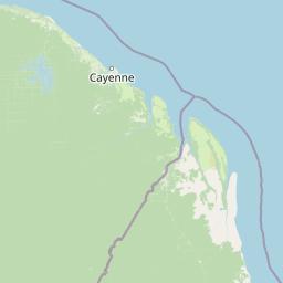
Map view of La Trinité National Nature Reserve

Use this park location map to pinpoint La Trinité National Nature Reserve in France, understand its exact geographic position, and read its mapped placement within the surrounding landscape more clearly.

Pigeon | © OpenStreetMap contributors

Location context for La Trinité National Nature Reserve

French Guiana
Park atlas

Compare diverse protected landscapes and regional geography beyond La Trinité National Nature Reserve.

Explore Nearby National Parks and Protected Areas Surrounding La Trinité National Nature Reserve
Browse other national parks and protected areas across French Guiana, comparing their distinct rainforest ecosystems, inselberg formations, and Amazon basin geography. Understand regional conservation landscapes, trace ecological connections, and discover the diverse natural features extending beyond La Trinité National Nature Reserve.
Nature reserveFrench Guiana

Nouragues Nature Reserve: Protected Nature Reserve Landscape within French Guiana's Amazon

Mapped geography featuring a distinct inselberg formation.

Nouragues Nature Reserve stands as a critical protected area within French Guiana, safeguarding a significant expanse of pristine lowland tropical rainforest. Its most defining characteristic is the Nouragues Inselberg, a colossal granite formation that dramatically punctuates the dense forest canopy. This reserve is not only a testament to conservation efforts but also a globally recognized hub for tropical forest ecology research. Exploring Nouragues Nature Reserve offers a unique lens into the natural processes and geological features of the Guiana Shield ecosystems.

Area
1,000 km²
Established
1995
IUCN
IV
Relief
Mixed relief
Nature reserveFrench Guiana

Mont Grand Matoury Nature Reserve: French Guiana's Protected Landscape and Mapped Geography

Explore its protected boundaries and regional terrain.

Mont Grand Matoury Nature Reserve is an integral part of the protected areas network in French Guiana, offering a specific focus on its natural landscape and geographic setting. This entry provides a structured overview of the reserve, detailing its mapped extent and its contribution to the regional geography. Users can delve into the specifics of this protected land, understanding its character and location within the wider context of France's overseas territories and the Amazonian biome.

Area
21.23 km²
Established
2006
IUCN
IV
Relief
Mixed relief
Nature reserveFrench Guiana

Trésor Regional Nature Reserve: Protected Nature Reserve in French Guiana's Guianas Region

Mapped Protected Landscape and Regional Geography

Investigate Trésor Regional Nature Reserve, a vital protected nature reserve located in French Guiana. This reserve is mapped as a significant component of the region's protected areas, contributing to the understanding of its unique tropical rainforest geography. Its designation underscores its importance for atlas exploration, offering structured insights into the natural landscapes that characterize this South American territory.

Area
24.64 km²
Established
2010
IUCN
IV
Relief
Mountain
Nature reserveFrench Guiana

Kaw-Roura Marshland Nature Reserve: A Protected Marshland Landscape in French Guiana

Explore its mapped terrain and regional geographic context.

Kaw-Roura Marshland Nature Reserve represents a distinct protected landscape within the tropical rainforests of French Guiana. This nature reserve offers detailed insights into marshland geography and terrain, contributing vital data for map-based exploration and understanding regional conservation patterns. Discover the specific protected boundaries and landscape character that define this important natural area, anchoring its identity within the larger geographic context of French Guiana.

Area
947 km²
Established
1998
IUCN
IV
Watercolor painting of a landscape with rolling hills, green trees, and soft color gradients
National parkFrench Guiana

Guiana Amazonian Park National Park: French Guiana's Expansive Protected Rainforest

Explore mapped boundaries and regional geographic context.

Guiana Amazonian Park, a cornerstone of protected land in French Guiana, offers a profound exploration of untamed Amazonian rainforest. As the largest national park in the European Union, it showcases a vast, remote ecosystem characterized by towering trees and intricate river systems. This page provides detailed context on its geographic placement within French Guiana and its significance as a major protected landscape for atlas-based discovery and understanding of tropical forest conservation.

Area
20,300 km²
Established
2007
IUCN
II
Relief
Lowland
National parkSuriname

Brownsberg Nature Park: Suriname National Park with Tropical Forest and Waterfall Landscapes

Mapped geography and protected landscape context.

Brownsberg Nature Park stands as a vital protected landscape within Suriname, distinguished by its central mountain, tropical forest ecosystems, and scenic waterfalls such as Leo Waterfall. The park's location overlooking the vast Brokopondo Reservoir provides a unique geographic setting, making it an important destination for atlas and map-based exploration of Suriname's natural heritage. Understanding Brownsberg Nature Park offers insight into the Neotropical biodiversity and terrain characteristic of the Guianan moist forests.

Area
122 km²
Established
1969
IUCN
II
Visitors
20K annual
Nature reserveSipaliwini District

Central Suriname Nature Reserve: Protected Nature Reserve with Mapped Geographic Context

Explore the landscape boundaries within Sipaliwini District's protected areas.

Central Suriname Nature Reserve is a significant protected area situated in Suriname's Sipaliwini District. As a designated nature reserve, it offers critical insights into regional geography and conservation landscapes. This page provides focused information on its mapped boundaries and its contribution to the broader atlas of protected lands, enabling detailed geographic discovery.

Area
16,000 km²
Established
1998
Relief
Mixed relief
Climate
Tropical
Protected areaGuyana

Kanashen Protected Area: Geographic Identity and Mapped Boundaries in Guyana

Explore the mapped landscape and protected land context.

Kanashen Protected Area serves as a critical point of geographic discovery within Guyana, offering detailed insights into its protected boundaries and natural landscape. This entry focuses on providing a structured, atlas-driven understanding of Kanashen, emphasizing its role within the regional geography of South America. Users can explore how this protected area fits into the larger mapped context, appreciating its specific terrain and conservation significance.

Area
6,485.67 km²
IUCN
VI
Relief
Mixed relief
Climate
Tropical

Common questions about visiting, size, designation, and location context for La Trinité National Nature Reserve

La Trinité National Nature Reserve FAQs for park facts, access, geography, and protected area context
Find quick answers about La Trinité National Nature Reserve, including protected-area facts, park geography, trail and visitor context, and how the park fits into its surrounding country and regional landscape.
MoriAtlas Explorer

Continue Your Protected Areas Search Across the Global Atlas

Deepen your exploration by continuing the structured search for national parks and protected areas worldwide. Utilize the comprehensive filtering capabilities to compare different conservation landscapes and refine your understanding of global park geography. Discover more about the distribution and characteristics of protected natural areas.

Global natural geography