Mori Atlas logo
National parkLake Kovada National Park

Discover the mapped geography and montane lake environment of this protected area in Isparta Province.

Lake Kovada National Park: National Park Landscape & Protected Area Boundaries

(Kovada Gölü Milli Parkı)

Lake Kovada National Park represents a significant protected landscape centered around its namesake freshwater lake in Turkey's Isparta Province. Established in 1970, this national park encompasses approximately 6,500 hectares, safeguarding a unique montane lake ecosystem nestled within the northern foothills of the Taurus Mountains. Users can explore the mapped boundaries and geographic context of this protected area, understanding its role as a representative example of lake-centered conservation in the Anatolian interior and its distinctive landscape character.

LakeNational ParkSouthwest TurkeyTaurus MountainsIsparta ProvinceMontane Landscape
Illustration of a lake surrounded by pine forests and mountains under a partly cloudy sky

Lake Kovada National Park

National park

Park overview

Structured park overview, official facts, and landscape profile for Lake Kovada National Park

Lake Kovada National Park park facts, protected area profile, and essential visitor context
Review the core facts for Lake Kovada National Park, including designation, size, terrain, visitor scale, habitats, and operating context in one park-focused overview.

About Lake Kovada National Park

Lake Kovada National Park protects a significant lake ecosystem in the heart of southwestern Turkey's mountainous interior. The park's core feature is Lake Kovada, a natural freshwater lake formed within a structural basin in the Taurus Mountain foothills. The surrounding landscape comprises a mix of woodland, scrub, and rocky terrain that frames the lake and contributes to the overall ecological character of the protected area. The park was formally established in November 1970, placing it among the pioneering national parks of Turkey's modern conservation era. Its designation reflected recognition of the lake's natural importance and the value of protecting this representative example of Anatolian montane lake environments. The park lies within Isparta Province, specifically in the districts of Sütçüler and Eğirdir, positioning it in a region known for its mountainous topography and relative remoteness from Turkey's coastal zones. Access to the park is provided via a 23-kilometer road that branches south from the main highway connecting Isparta, Eğirdir, and Konya. Within the park boundaries, basic visitor facilities have been developed to support camping and day-use recreation, with visitors typically accommodated in tents or caravans rather than formal lodging structures.

Quick facts and research context for Lake Kovada National Park

Lake Kovada National Park is located in Isparta Province in southwestern Turkey, approximately 23 kilometers south of the Eğirdir district along a branch road from the Isparta-Eğirdir-Konya state highway. The park was established on November 3, 1970, making it one of Turkey's older national parks. The protected area covers roughly 6,500 hectares centered on Lake Kovada, a natural freshwater lake in a mountain basin setting. The Ministry of Forest and Water Management oversees the park's administration. Visitors have access to basic recreational facilities including designated picnic areas and camping opportunities with accommodation in tents and caravans rather than permanent structures.

Park context

Deeper park guide and search-rich context for Lake Kovada National Park

Lake Kovada National Park history, landscape, wildlife, and travel context
Explore Lake Kovada National Park through its history, landscape character, ecosystems, wildlife, conservation priorities, cultural context, and seasonal travel timing in a structured park guide built for atlas discovery and search intent.

Why Lake Kovada National Park stands out

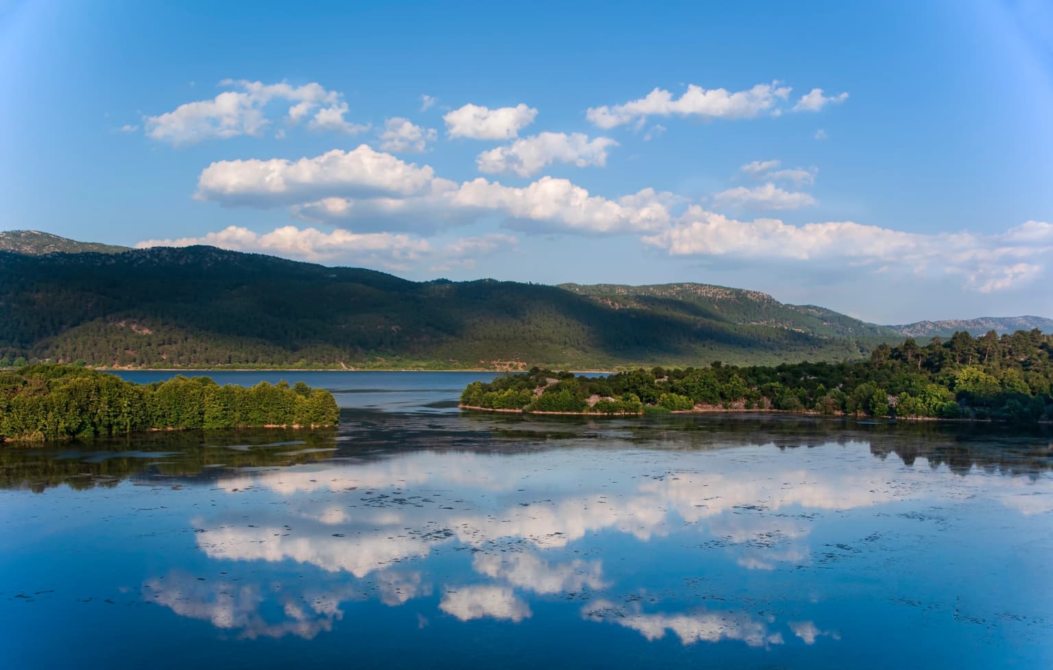
Lake Kovada National Park is best known for its namesake lake, a scenic freshwater body set within a mountain basin surrounded by forested terrain in the Taurus Mountain region. The park represents one of Turkey's key lake-focused protected areas, offering a distinctive combination of aquatic habitat, riparian zones, and upland forest in a relatively accessible location within the Anatolian interior. The lake itself serves as the primary visual and ecological anchor of the park, with its still waters, surrounding shoreline, and the transition to woodland and mountainous terrain creating a recognizable landscape character. The park's longevity since 1970 also establishes it as an established destination within Turkey's national park system.

Lake Kovada reflecting clouds and sky with mountains in the background.
Reflective surface of Lake Kovada with mountains and clouds under a bright sky.

Lake Kovada National Park history and protected-area timeline

Lake Kovada National Park was established on November 3, 1970, marking it as one of the earlier national parks created in Turkey under the country's modern national park legislation. The establishment reflected a growing recognition during the 1960s and early 1970s of the need to designate and protect significant natural areas across Turkey's diverse landscapes. Lake Kovada was identified as a candidate for protection due to its scenic and ecological value as a natural lake in a mountainous setting. The decision to create the national park followed broader governmental interest in developing a network of protected areas that would preserve representative examples of Turkey's natural heritage. The park has maintained its protected status continuously since 1970, with management responsibility assigned to the relevant national authority overseeing forestry and water management. Over the more than five decades since its establishment, the park has functioned as a designated conservation area and a destination for visitors seeking to experience a protected lake environment in the Anatolian interior.

Lake Kovada National Park landscape and geographic character

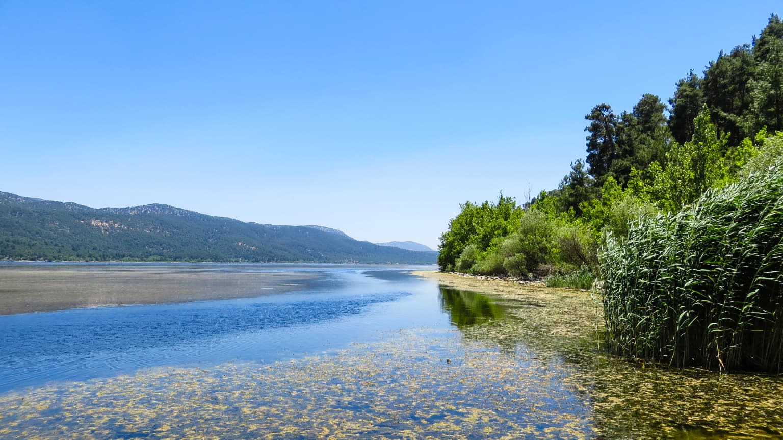
The landscape of Lake Kovada National Park centers on the lake basin itself—a natural freshwater lake occupying a structural depression within the mountainous terrain of the Taurus foothills. The lake sits at an elevation that places it in a montane setting, surrounded by slopes that rise toward higher terrain in the surrounding landscape. The shoreline of the lake varies between more gently sloped sections and areas where the terrain rises more directly from the water's edge. Beyond the immediate lake margin, the park encompasses forested slopes and transitional terrain that connects the lake basin to the broader watershed. The overall visual character combines the still waters of the lake with the green vegetation of the surrounding woodland and the mountainous backdrop, creating a landscape that is distinctly inland and removed from Turkey's coastal environments.

Calm lake with reeds on the right, reflecting blue sky and mountains in the background
Lake Kovada with reeds along the shoreline and distant mountains under a clear blue sky

Lake Kovada National Park ecosystems, habitats, and plant life

Lake Kovada National Park encompasses a lake-centered ecosystem that includes the open water habitat of the lake itself, shoreline and riparian zones where vegetation meets the water, and the forested and scrubland slopes that surround the basin. The lake provides important aquatic habitat within an otherwise predominantly terrestrial mountainous landscape. The surrounding vegetation includes woodland typical of the Taurus Mountain region, with species adapted to the continental climate and elevation of the area. The lake and its supporting watershed function as a self-contained hydrological unit, with the water body fed by local runoff and groundwater from the surrounding terrain. This combination of aquatic, riparian, and terrestrial habitats creates a relatively diverse ecological setting within the protected area.

Lake Kovada National Park wildlife and species highlights

The lake environment of Lake Kovada National Park supports aquatic wildlife including fish populations that inhabit the freshwater waters. The surrounding forested and scrubland areas provide habitat for typical species of the Taurus Mountain region, including various bird species that use the lake and its margins for feeding and nesting. The combination of open water, shoreline vegetation, and woodland creates a habitat mosaic that supports both water-associated species and terrestrial wildlife in the surrounding terrain.

Lake Kovada National Park conservation status and protection priorities

Lake Kovada National Park represents a long-standing protected area within Turkey's national park system, with conservation focused on maintaining the integrity of the lake ecosystem and the surrounding natural landscape. The park's designation in 1970 reflected early recognition of the need to protect significant natural lakes within Turkey's interior regions. The protected status aims to preserve the lake's water quality, shoreline character, and the ecological relationships between the aquatic and terrestrial components of the park. As a national park, the area receives formal recognition and management attention aimed at balancing conservation objectives with limited recreational use. The park serves as an example of lake protection in a region where inland freshwater environments face various pressures from development and resource use.

Lake Kovada National Park cultural meaning and human context

Lake Kovada National Park is situated within a region of southwestern Anatolia that has historical connections to agricultural and pastoral communities. The surrounding area of Isparta Province has traditionally been associated with fruit cultivation, livestock keeping, and settlement in the mountain valleys and plains. The park's lake and its watershed have likely been used historically by local communities for fishing, water access, and grazing in the surrounding terrain, though the protected status now limits some traditional uses within the park boundaries. The park's establishment in 1970 represented a formalization of conservation values that overlaid continued but regulated use of the area for recreation and nature appreciation.

Top sights and standout views in Lake Kovada National Park

Lake Kovada National Park's defining highlight is its namesake lake—a scenic mountain lake set in the Taurus foothills of southwestern Turkey, protected since 1970. The park offers a distinctly inland nature experience far from Turkey's coastal tourist zones, with the lake providing a central focal point for exploration and appreciation. The combination of still lake waters, surrounding woodland, and mountain backdrop creates a recognizable and peaceful landscape. Visitor facilities support camping and day-use recreation, making it accessible for those seeking a nature-oriented visit to a protected lake environment in Anatolia.

Best time to visit Lake Kovada National Park

Lake Kovada National Park can be visited throughout the year, though the best times for experiencing the park's landscape are during the spring and summer months when weather conditions are more favorable for outdoor activities. The lake and surrounding terrain are most accessible and inviting during the warmer period from May through September, when visitors can fully enjoy the camping and picnic facilities. Winter visitation is possible but the mountainous setting means cooler temperatures and potentially more limited access to some areas. The park's inland location means it experiences a continental climate with distinct seasons, and the character of the lake and surrounding landscape changes accordingly through the year.

Park location guide

Geography guide, regional context, and park location map for Lake Kovada National Park

Lake Kovada National Park park geography, regions, and map view in Turkey
Understand where Lake Kovada National Park sits in Turkey through a broader geographic reading of the surrounding landscape, nearby location context, and its mapped position within the national park landscape.

How Lake Kovada National Park fits into Turkey

Turkey, officially the Republic of Türkiye, is a transcontinental country located mainly in Anatolia (West Asia) with a smaller portion in East Thrace (Southeast Europe). It borders the Black Sea to the north, several countries to the east and south, and the Aegean Sea and European countries to the west. The country has a population of over 86 million and operates as a secular, Muslim-majority presidential republic with Ankara as capital and Istanbul as its largest city.

Wider geography shaping Lake Kovada National Park in Turkey

Turkey is a transcontinental country with the majority of its territory (about 97%) located in Anatolia (West Asia) and a smaller portion called East Thrace in Southeast Europe. It borders the Black Sea to the north, Georgia, Armenia, Azerbaijan, and Iran to the east, Iraq and Syria to the south, and the Mediterranean Sea to the southwest. To the west, Turkey borders the Aegean Sea, Greece, and Bulgaria. The terrain includes mountains, plateaus, and coastal plains, with the Taurus Mountains running along the southern coast.

Map view of Lake Kovada National Park

Use this park location map to pinpoint Lake Kovada National Park in Turkey, understand its exact geographic position, and read its mapped placement within the surrounding landscape more clearly.

Pigeon | © OpenStreetMap contributors

Location context for Lake Kovada National Park

Isparta Province

Explore the visual character of Lake Kovada's freshwater basin, forested slopes, and protected montane landscape in Turkey.

Lake Kovada National Park Photos: Visualizing Protected Montane Lake Landscapes and Park Scenery
Browse through comprehensive imagery showcasing the unique landscapes and natural habitats of Lake Kovada National Park, revealing its central freshwater lake, surrounding forested slopes, and diverse montane terrain. This visual documentation offers essential context, allowing users to deeply understand the park's protected environment and its distinctive geographic character within Turkey's Taurus Mountain region.

Lake Kovada reflecting clouds and sky with mountains in the background.

A panoramic view of Lake Kovada showing clear shallow water, rocky shore, and mountainous backdrop under a clear blue sky

Calm lake with reeds on the right, reflecting blue sky and mountains in the background

Park atlas

Explore the regional spread of protected landscapes, comparing lake environments and surrounding montane terrain in the Turkish interior.

Discover Other National Parks and Protected Areas Near Lake Kovada National Park
After exploring Lake Kovada National Park, browse other national parks and protected areas situated within southwestern Turkey and the broader Taurus Mountains region. This expanded geographic context allows for comparison of diverse conservation landscapes, from additional lake basins to forested uplands and mountain-valley ecosystems.
Watercolor illustration of green hills, pine trees, and distant mountains under a light sky
National parkIsparta Province

Kızıldağ National Park: Protected Taurus Mountain Landscape and Atlas Context

Mapped boundaries, alpine terrain, and unique cedar forests.

Kızıldağ National Park offers a detailed look into Turkey's protected natural heritage, specifically highlighting the dramatic mountainous terrain of the Taurus Ranges. This page provides atlas-level geographic information about its mapped boundaries, the significant Dedegöl Mountain, and the rare blue-leaf cedar forests unique to this region. Understand its role as a vital conservation area within Isparta Province and the broader Mediterranean mountain ecosystem.

Area
551.06 km²
Established
1969
Relief
Mountain
Scope
Terrestrial
National parkTurkey

Derebucak Çamlık Caves National Park: Turkey's Protected Karst Caves and Landscape

Explore Konya Province's longest cave system and its unique geological context.

Derebucak Çamlık Caves National Park is a vital protected landscape in central Turkey, celebrated for its extensive karst topography and significant cave formations. This national park encompasses thirteen unique caves and sinkholes, with Balatini Cave holding the distinction of being Konya Province's longest. The park's rugged terrain, characterized by pine forests and the Balat Stream feeding its underground systems, offers a profound look into Turkey's geological heritage and the conservation of its unique subterranean environments. MoriAtlas helps you navigate this mapped protected area.

Area
11.47 km²
Established
2022
Watercolor painting of colorful rowboats on a lake with distant mountains
National parkKonya Province

Lake Beyşehir National Park: Protected Landscape Geography and Mapped Boundaries

Discover the geography and mapped context of this national park in Konya.

Lake Beyşehir National Park is a major protected area in Turkey's Central Anatolia region, celebrated for its immense freshwater lake and diverse wetland habitats. The park's identity is strongly tied to its mapped boundaries that protect critical ecosystems, islands, and surrounding forested terrain. This page provides a detailed look at the park's geographic setting within Konya Province, serving as a valuable resource for atlas-based discovery of its unique natural and cultural landscape.

Area
868.55 km²
Established
1993
Relief
Lowland
Climate
Temperate
Watercolor illustration showing a mountainous landscape with a lake and greenery
National parkAntalya Province

Altınbeşik Cave National Park: A Karst Landscape with Turkey's Largest Subterranean Lake

Protected lands and mapped geological formations in Antalya Province.

Altınbeşik Cave National Park represents a significant protected karst landscape within Antalya Province, Turkey. The park's primary feature is the renowned Altınbeşik Cave, home to Turkey's largest subterranean lake and exceptional travertine formations. Explore the mapped geography of this unique national park, understanding its role as a critical discharge point for one of the world's longest karst aquifer systems.

Area
11.47 km²
Established
1994
Relief
Mixed relief
Climate
Mediterranean
Protected areaTurkey

Commander-in-Chief National Historic Park: Historic Battlefield Landscape in Turkey

Protected Area preserving pivotal geography and military history.

Commander-in-Chief National Historic Park is a designated protected area in Turkey, preserving the historic terrain of the decisive Battle of Dumlupınar. This site offers a unique glimpse into the geography and landscape that were instrumental in a key moment of the Turkish War of Independence. Explore the mapped context of this significant battlefield, understanding its role within the broader Anatolian geography and its importance as a preserved historic site.

Area
409.48 km²
Established
1981
Relief
Mixed relief
Climate
Temperate
Watercolor painting of a river flowing through green hills and mountains under a soft sky.
National parkMuğla Province

Saklıkent National Park: Explore Turkey's Deepest Gorge, Limestone Formations, and Protected Terrain

A remarkable national park showcasing dramatic canyon geography and karst landscapes.

Saklıkent National Park presents an extraordinary example of a protected landscape dominated by a deep limestone canyon in Muğla Province, Turkey. This national park invites exploration of its striking geological features, including towering cliffs and flowing karstic springs that form a spectacular gorge. Users engaging with Saklıkent National Park gain insight into the mapped boundaries of protected areas and the unique natural terrain sculpted by water over millennia, offering a rich geographic context for atlas discovery.

Area
16.43 km²
Established
1996
Visitors
200K annual
Relief
Mountain
National parkMuğla Province

Marmaris National Park: Mediterranean Forest Protected Landscape and Ancient Heritage

Discover its geography, mapped boundaries, and unique flora.

Marmaris National Park in Muğla Province offers a deep dive into a protected Mediterranean forest ecosystem and Carian history. Explore its rugged terrain, dramatic coastlines where pine forests meet the sea, and discover ancient sites like the Amos amphitheatre. This park is a key area for understanding regional geography, mapped natural landscapes, and the unique botanical diversity of Turkey's southwestern coast, supporting detailed atlas exploration.

Area
333.5 km²
Established
1996
Visitors
8.5M annual
Relief
Mixed relief
National parkAnkara Province

Mount Sarıçalı National Park: Turkey's Newest Protected Mountain Landscape

Ancient forests, endemic botany, and dramatic mountain terrain.

Mount Sarıçalı National Park, located in Ankara Province, Turkey, is a testament to the nation's commitment to conservation. This protected area is celebrated for its ancient forests, with larch, Kasnak oak, and juniper trees dating back 700-800 years. Its position at the confluence of three phytogeographic zones supports a rich array of 139 endemic plant species. The park's landscape is further characterized by the striking Uyuzsuyu Waterfall and the imposing Mount Sarıçalı peak, offering a profound geographic context for atlas exploration.

Area
10.24 km²
Established
2021
Relief
Mountain
Scope
Terrestrial

Common questions about visiting, size, designation, and location context for Lake Kovada National Park

Lake Kovada National Park FAQs for park facts, access, geography, and protected area context
Find quick answers about Lake Kovada National Park, including protected-area facts, park geography, trail and visitor context, and how the park fits into its surrounding country and regional landscape.
MoriAtlas Explorer

Continue Your Protected Areas Search Across the Global Atlas

Deepen your exploration by continuing the structured search for national parks and protected areas worldwide. Utilize the comprehensive filtering capabilities to compare different conservation landscapes and refine your understanding of global park geography. Discover more about the distribution and characteristics of protected natural areas.

Global natural geography