Mori Atlas logo
National parkLas Palmas de Cocalán National Park

Discover the mapped boundaries and regional setting of this national park in Chile.

Las Palmas de Cocalán National Park: Protected Landscape and Geographic Context

(Parque Nacional Las Palmas de Cocalán)

Las Palmas de Cocalán National Park represents a significant protected area within the geographic atlas of Chile's Libertador General Bernardo O'Higgins Region. This page offers a deep dive into its protected landscape characteristics, providing essential context for understanding its mapped boundaries and regional natural terrain. Explore the unique geography that defines this national park, contributing to a structured understanding of conservation lands.

Chilean palm forestEndemic species protectionPrivate land conservationMediterranean ecosystemAncient forestVulnerable species habitat

Las Palmas de Cocalán National Park

National park

Park overview

Structured park overview, official facts, and landscape profile for Las Palmas de Cocalán National Park

Las Palmas de Cocalán National Park park facts, protected area profile, and essential visitor context
Review the core facts for Las Palmas de Cocalán National Park, including designation, size, terrain, visitor scale, habitats, and operating context in one park-focused overview.

About Las Palmas de Cocalán National Park

Las Palmas de Cocalán National Park occupies a special position within Chile's national park system as the country's first and only protected area established entirely on private land. The park is situated in the Cocalán basin within the commune of Las Cabras, in the coastal mountain range of central Chile. Its primary ecological significance lies in the protection of Jubaea chilensis, the Chilean palm, a species that once dominated extensive areas of central Chile but now survives in only a few remnant populations. The park was created in 1971 following concern about the vulnerability of this iconic palm species, though official declaration as a national park came in 1989 through joint action by Chile's Ministry of National Assets and Ministry of Agriculture. The Cocalán basin contains an estimated 35,000 or more Chilean palm specimens, representing one of the three major populations of this species protected within Chile's wilderness areas. Unlike typical national parks with public access infrastructure, Las Palmas de Cocalán operates under a special management model where the private landowners maintain productive agricultural use of the surrounding lands while the core palm forest receives national protection.

Quick facts and research context for Las Palmas de Cocalán National Park

Located in the Chilean Coast Range (Cordillera de la Costa) near the town of Rengo, the park covers 3.709 square kilometers of terrain centered on ancient Chilean palm forests. The Chilean palm is a slow-growing species capable of living more than 1,000 years, with trunk diameters and heights that make the Cocalán basin specimens the most impressive in the country. The park exists within productive private agricultural lands, making it unique among Chile's national parks for its land tenure arrangement. Access is restricted and managed through the Hacienda Las Palmas de Cocalán, with guided educational visits available since 2018.

Park context

Deeper park guide and search-rich context for Las Palmas de Cocalán National Park

Las Palmas de Cocalán National Park history, landscape, wildlife, and travel context
Explore Las Palmas de Cocalán National Park through its history, landscape character, ecosystems, wildlife, conservation priorities, cultural context, and seasonal travel timing in a structured park guide built for atlas discovery and search intent.

Why Las Palmas de Cocalán National Park stands out

Las Palmas de Cocalán is best known for its ancient forests of the Chilean palm (Jubaea chilensis), one of the world's southernmost palm species and endemic to Chile. The park contains some of the oldest, tallest, and thickest specimens of this vulnerable palm species, representing a living relic of Chile's unique Mediterranean-climate ecosystems. The combination of extreme longevity in the palm trees, the restricted access due to private land ownership, and the park's status as the only national park in Chile on private property make it uniquely significant in the country's protected area system.

Las Palmas de Cocalán National Park history and protected-area timeline

The history of Las Palmas de Cocalán reflects both the cultural significance of the Chilean palm and the evolution of conservation in Chile. By the nineteenth century, the palms of the Cocalán estate were already objects of regional admiration, and in 1873, several specimens were transplanted to Santiago at the request of Intendant Benjamín Vicuña Mackenna for ornamental purposes, notably planting some on Cerro Santa Lucía. The species was later catalogued as vulnerable due to habitat loss and exploitation, prompting conservation action. The park was initially created in 1971 with the support of local residents who recognized the need to protect the palm population. In 1989, it was officially declared a national park by the Chilean Ministry of National Assets and Ministry of Agriculture, becoming part of a network of protected areas safeguarding the Chilean palm from extinction. Other protected areas in this network include La Campana National Park, which holds the largest palm population in Chile, and Los Palmares de Ocoa, a protected zone serving as a reserve. The unique private-land tenure model means that public access was historically restricted, though guided educational visits began in 2018 through collaboration with the hacienda owners and local guides.

Las Palmas de Cocalán National Park landscape and geographic character

The park is situated in the Cordillera de la Costa, the coastal mountain range of central Chile, within a valley basin environment that supports the palm forest ecosystem. The landscape consists of gently rolling terrain interspersed with the distinctive silhouettes of ancient Chilean palms rising above the understory vegetation. The Chilean Coast Range in this region creates a transitional zone between the higher Andes Mountains to the east and the Pacific coastal plain. The soils and climate of the Cocalán basin support a Mediterranean-type ecosystem with characteristic vegetation adapted to seasonal dry summers and wet winters. The palm forests create a visually distinctive landscape unlike typical temperate forests, with the tall, stout trunks of Jubaea chilensis forming an open canopy that allows light to penetrate to the forest floor.

Las Palmas de Cocalán National Park ecosystems, habitats, and plant life

The park protects one of Chile's most ecologically significant native palm forests, centered on Jubaea chilensis, the Chilean palm, which represents the southernmost extent of the palm family in the world and is endemic to Chile. This species can live for more than a millennium, with individual specimens in the Cocalán basin achieving remarkable dimensions in both height and trunk thickness, making them the largest Chilean palms in the country. The forest exists within a Mediterranean-climate ecosystem characterized by dry summers and autumns, with most precipitation falling during the winter months. The park forms part of a network of three protected areas in Chile that conserve ancient Chilean palm populations, collectively representing a critical stronghold for this endemic species. The vegetation community includes the Chilean palm as the dominant species, with associated native understory plants adapted to the unique microclimate created by the palm canopy.

Las Palmas de Cocalán National Park wildlife and species highlights

While the park is primarily celebrated for its botanical significance as a Chilean palm forest, the protected ecosystem supports various wildlife adapted to the Mediterranean-climate woodlands of central Chile. The ancient palm forest provides habitat and foraging resources for birds and small mammals native to this region. The structural complexity of the old-growth palm forest, with its large trunks and scattered canopy, creates microhabitats supporting biodiversity. The park's location within the broader Cocalán basin and its proximity to agricultural lands creates an interface between protected native habitat and working landscape, with species adapted to both environments. While detailed species inventories are not prominent in available sources, the intact palm forest ecosystem clearly provides ecological functions for regional wildlife populations.

Las Palmas de Cocalán National Park conservation status and protection priorities

Las Palmas de Cocalán represents a unique conservation model in Chile as the first and only national park established on private land, demonstrating how protected area designation can function collaboratively with private land stewardship. The park was established specifically to protect Jubaea chilensis, the Chilean palm, which was classified as a vulnerable species due to historical habitat loss and exploitation for palm honey production and other uses. The protected area forms part of a three-site network protecting ancient Chilean palm forests in Chile, alongside La Campana National Park and the Los Palmares de Ocoa protected zone. Conservation of this species is particularly significant given its extreme longevity and limited distribution, with the Cocalán basin specimens representing some of the most impressive individuals of this endemic palm anywhere in Chile. The restricted access policy, while limiting traditional tourism, serves a conservation function by minimizing disturbance to the sensitive ecosystem.

Las Palmas de Cocalán National Park cultural meaning and human context

The Chilean palm holds significant cultural value in Chile, with historical connections to the country's landscape identity and traditional practices. The Cocalán palms were already noted as remarkable specimens in the nineteenth century, leading to their transplantation to Santiago's Cerro Santa Lucía in 1873, where they remain visible today. The species has traditionally been used to produce palm honey (miel de palma), a sweetener derived from the sap of the palm, a practice that contributed to historical population declines and continues in the surrounding productive lands. The park exists within the Hacienda Las Palmas de Cocalán, an active agricultural property, representing a model where conservation operates alongside ongoing land use rather than displacing it. Since 2018, guided educational tours have created a new layer of cultural engagement, allowing visitors to learn about the palm's natural history and cultural significance through local guides.

Top sights and standout views in Las Palmas de Cocalán National Park

The ancient Chilean palm forests of Las Palmas de Cocalán represent one of the three great palm forest protected areas in Chile, with specimens among the tallest and thickest of this endemic species in the country. The park's unique status as Chile's only national park on private land demonstrates an innovative conservation model balancing private land stewardship with national protection. The extreme longevity of the Chilean palm, with individuals capable of living over 1,000 years, makes this forest a living historical record spanning multiple centuries. The restricted access has preserved the ecosystem from heavy visitation impacts, maintaining a more natural state than typical national parks. The guided educational tours introduced in 2018 provide controlled access for those seeking to experience this remarkable palm forest while ensuring conservation safeguards.

Best time to visit Las Palmas de Cocalán National Park

The park's location in central Chile's Mediterranean climate means that the best conditions for visiting occur during the Chilean spring and early summer months from October through December, when weather is mild and the landscape is vibrant following winter rains. The summer months of January through March can be hot and dry, while the winter brings rainfall that may affect access on the private lands. Since visits are conducted through pre-arranged guided tours via the Hacienda Las Palmas de Cocalán, visitors must coordinate their trip in advance rather than arriving independently. The controlled visitation model ensures that access is managed according to conservation priorities and available capacity, making advance planning essential regardless of season.
Park location guide

Geography guide, regional context, and park location map for Las Palmas de Cocalán National Park

Las Palmas de Cocalán National Park park geography, regions, and map view in Chile
Understand where Las Palmas de Cocalán National Park sits in Chile through a broader geographic reading of the surrounding landscape, nearby location context, and its mapped position within the national park landscape.

How Las Palmas de Cocalán National Park fits into Chile

Chile is a presidential republic in western South America, extending as a narrow strip along the western edge of the continent between the Andes Mountains and the Pacific Ocean. It is the southernmost country in the world and the closest to Antarctica. The country is bordered by Peru, Bolivia, and Argentina, and administers several Pacific islands including Easter Island. Chile is a major copper producer and has a population of approximately 19.6 million.

Wider geography shaping Las Palmas de Cocalán National Park in Chile

Chile occupies a narrow strip of land along the western edge of South America, extending approximately 4,300 km north to south but only about 350 km east to west at its widest point. The country is sandwiched between the Andes Mountains to the east and the Pacific Ocean to the west. It shares borders with Peru to the north, Bolivia to the northeast, and Argentina to the east. Southern Chile borders the Drake Passage. Chile also administers several Pacific islands including Juan Fernández Islands, Isla Salas y Gómez, Desventuradas Islands, and Easter Island, plus the Chilean Antarctic Territory.

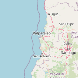
Map view of Las Palmas de Cocalán National Park

Use this park location map to pinpoint Las Palmas de Cocalán National Park in Chile, understand its exact geographic position, and read its mapped placement within the surrounding landscape more clearly.

Pigeon | © OpenStreetMap contributors

Location context for Las Palmas de Cocalán National Park

Libertador General Bernardo O'Higgins Region
Park atlas

Explore surrounding protected areas and compare diverse conservation landscapes across Central Chile's unique geography.

Discover Nearby National Parks and Protected Areas Related to Las Palmas de Cocalán
After exploring Las Palmas de Cocalán National Park, browse other national parks and protected areas to understand the wider conservation efforts in central Chile. Compare geographic features, unique ecosystems, and diverse landscapes found in adjacent protected zones, expanding your atlas-style exploration of the region's natural heritage.
Watercolor painting of a coastal landscape featuring palm trees, mountains, and a body of water
National parkValparaíso Region

La Campana National Park: Protected Landscape of Chilean Wine Palms

Explore its mapped terrain and regional geographic context.

La Campana National Park represents a significant protected landscape within Chile, celebrated for its exceptional concentration of Chilean Wine Palms (Jubaea chilensis). As a national park situated in the Valparaíso Region, it showcases a diverse range of Mediterranean ecosystems and dramatic coastal mountain terrain. This page provides detailed atlas-style context, highlighting the park's unique botanical heritage, its distinct geographic setting, and its importance as a mapped natural area for regional landscape studies.

Area
80 km²
Established
1967
IUCN
II
Visitors
39.6K annual
National park

El Leoncito National Park: High-Altitude Andean Puna and Steppe Protected Landscape

Explore mapped boundaries and unique geographic context in San Juan Province.

El Leoncito National Park in Argentina's San Juan Province preserves critical high-altitude ecosystems, including the Central Andean Puna and Southern Andean steppe. This protected landscape spans dramatic mountain terrain, with elevations reaching over 6,000 meters, providing a unique geographic setting. The park's conservation value is underscored by its representative ecological samples and stark natural beauty, offering a distinct regional geography for exploration.

Area
897.06 km²
Established
2002
IUCN
II
Relief
Mountain
National parkBío Bío Region

Laguna del Laja National Park: Mapped Protected Area in Chile's Bío Bío Region

Explore regional park geography and landscape context.

Laguna del Laja National Park represents a key protected area with distinct geographic attributes within the Bío Bío Region. This profile focuses on its identity as a national park, providing context for its mapped boundaries and natural landscape. Discover its place in regional geography, offering valuable insights for any atlas-focused exploration of Chile's protected lands.

Area
119 km²
Established
1958
IUCN
II
Visitors
48.8K annual
Watercolor illustration of a river winding through a valley with rolling hills and green vegetation in the foreground.
National parkCoquimbo Region

Bosque de Fray Jorge National Park: National Park Protected Landscape & Geographic Atlas

Explore mapped boundaries and regional natural landscape context.

Bosque de Fray Jorge National Park is a key protected area offering unique insights into Chile's natural landscapes. This entry provides detailed geographic context, focusing on its status as a national park and its mapped boundaries within the Coquimbo Region. Discover its place in the regional atlas and understand its protected landscape identity for focused geographic exploration.

Area
100 km²
Established
1941
IUCN
II
Visitors
13.1K annual
National park

Sierra de las Quijadas National Park: Protected Landscape & Geographic Atlas in Argentina

Explore the unique Chaco-Monte ecotone and dramatic sandstone terrain.

Sierra de las Quijadas National Park in San Luis Province, Argentina, is a protected area recognized for its critical role as a biodiversity bridge between the Semiarid Chaco and High Monte ecoregions. Its landscape is marked by rugged mountains, vivid red sandstone cliffs, and significant paleontological sites, offering a unique look at Cretaceous-era geology. This park provides a rich opportunity for atlas exploration, allowing discovery of its distinctive protected landscape and the regional geography it inhabits.

Area
735.33 km²
Established
1991
IUCN
II
Relief
Mountain
National parkLa Araucanía Region

Nahuelbuta National Park: Ancient Araucaria Forests and Protected Highland Geography

Discover its mapped boundaries atop the Cordillera de Nahuelbuta.

Nahuelbuta National Park is a significant national park in Chile's La Araucanía Region, celebrated for its ancient monkey puzzle tree forests atop the Cordillera de Nahuelbuta. This protected area showcases a unique highland landscape with rugged terrain and exposed rocky outcrops, preserving species more typical of Andean and Patagonian environments. Understanding its mapped geography and protected landscape identity is key to appreciating its ecological importance and distinct position within South America's natural atlas.

Area
68 km²
Established
1939
IUCN
II
Relief
Mountain
National parkChile

Tolhuaca National Park National Park: Mapped Boundaries and Chilean Geography

Explore the protected landscape and regional context of this park.

Tolhuaca National Park is a protected national park located in Chile, offering a distinct point for geographic and landscape discovery. This detailed view focuses on the park's mapped boundaries, its environmental setting within Chile, and its overall protected-area identity. Engage with structured data that clarifies its position in the broader atlas of natural landscapes, providing context for regional geography and conservation efforts.

Area
64.74 km²
Established
1935
IUCN
II
Visitors
6.5K annual
National parkNeuquén Province

Laguna Blanca National Park: National Park in Neuquén Province, Patagonia

Mapped protected area and regional landscape context.

Laguna Blanca National Park represents a key protected landscape within the expansive geography of Neuquén Province, located in the Patagonia region of Argentina. This national park entity serves as a critical node for atlas exploration, allowing users to understand its specific protected boundaries and its contribution to the regional protected-area network. Investigate Laguna Blanca National Park to gain insight into its unique geographic setting and its role within the mapped natural areas of Western Argentina.

Area
112.5 km²
Established
1940
IUCN
II
Relief
Upland

Common questions about visiting, size, designation, and location context for Las Palmas de Cocalán National Park

Las Palmas de Cocalán National Park FAQs for park facts, access, geography, and protected area context
Find quick answers about Las Palmas de Cocalán National Park, including protected-area facts, park geography, trail and visitor context, and how the park fits into its surrounding country and regional landscape.
MoriAtlas Explorer

Continue Your Protected Areas Search Across the Global Atlas

Deepen your exploration by continuing the structured search for national parks and protected areas worldwide. Utilize the comprehensive filtering capabilities to compare different conservation landscapes and refine your understanding of global park geography. Discover more about the distribution and characteristics of protected natural areas.

Global natural geography