Mori Atlas logo
National parkLiesjärvi National Park

Discover the geographic identity and protected area boundaries of Liesjärvi National Park.

Liesjärvi National Park: A Mapped Protected Landscape within Kanta-Häme's Geography

(Liesjärven kansallispuisto)

Liesjärvi National Park stands as a significant protected area within the Kanta-Häme region of southern Finland, embodying the Finnish Lakeland's natural heritage. This national park offers a distinct geographic canvas, characterized by its mapped landscape and conservation status. As part of MoriAtlas's structured exploration of natural terrains and protected lands, Liesjärvi National Park provides vital context for understanding regional geography and the distribution of conservation efforts in Finland.

National parkBoreal forestOld-growth forestLake highlandsSouthern FinlandWetlands
Stylized illustration showing mountains with waterfall, river flowing through forested valley

Liesjärvi National Park

National park

Park overview

Structured park overview, official facts, and landscape profile for Liesjärvi National Park

Liesjärvi National Park park facts, protected area profile, and essential visitor context
Review the core facts for Liesjärvi National Park, including designation, size, terrain, visitor scale, habitats, and operating context in one park-focused overview.

About Liesjärvi National Park

Liesjärvi National Park sits in the lake-highland region of Häme in southern Finland, spanning an area of approximately 21 to 22 square kilometres across the municipalities of Tammela, Somero, and Karkkila. Established in 1956, it ranks among Finland's older national parks and has been expanded in subsequent decades, particularly in the 1980s and 2000s. The park protects a representative slice of the near-natural landscapes that characterise this part of Finland, where undulating terrain and abundant lakes create a distinctive mosaic of habitats. The park's name derives from Liesjärvi, a lake with a sandy bottom that lies adjacent to but outside the protected area, though the lake's islands fall within the park's boundaries. The landscape features glacial ridges, wetland areas, and forests ranging from dense spruce stands to more open pine-dominated heaths. Several trails traverse the park, connecting visitors with its varied scenery and heritage sites, while the broader Häme Ilvesreitistö network extends over 200 kilometres through the region. The park is managed by Metsähallitus and receives approximately 57,000 visitors annually, making it a important destination for outdoor recreation in southern Finland.

Quick facts and research context for Liesjärvi National Park

Liesjärvi National Park spans roughly 21 square kilometres in the Kanta-Häme region of southern Finland, making it one of the country's smaller yet older protected areas established in 1956. The park encompasses diverse terrain including dense spruce forests, open pine heaths, wetland mires, glacial ridges, and a network of lakes and ponds with nearly 50 kilometres of total shoreline. The landscape represents the classic lake highlands of Häme, a region known for its undulating terrain and abundant water bodies. The park includes the historic Korteniemen perinnetila, the only forest guard station in Southern Finland to retain its original yard layout from the early 1900s. The park forms part of the broader Häme Ilvesreitistö trail network spanning over 200 kilometres, with about 30 kilometres of marked paths within the park itself.

Park context

Deeper park guide and search-rich context for Liesjärvi National Park

Liesjärvi National Park history, landscape, wildlife, and travel context
Explore Liesjärvi National Park through its history, landscape character, ecosystems, wildlife, conservation priorities, cultural context, and seasonal travel timing in a structured park guide built for atlas discovery and search intent.

Why Liesjärvi National Park stands out

Liesjärvi National Park is best known for its combination of ancient forest preservation and cultural landscape stewardship. The Ahonnokan and Isosaari areas contain old-growth forests that have been protected as conservation forests since 1929, representing some of the finest examples of near-natural forest in southern Finland. The park is also distinguished by Korteniemen perinnetila, a heritage farmstead where visitors can experience traditional agricultural practices and observe a preserved forest guard station from the early 1900s. The Kyynäränharju ridge offers scenic views over the lake landscape, while the diverse habitat types support everything from old-growth spruce forests to wetland mires. The park's proximity to Helsinki and its integration into the longer Häme Ilvesreitistö trail network make it a gateway to Finnish wilderness for millions of southern residents.

A stream flows through a forested area with moss-covered rocks and fallen branches
Stream flowing through forested terrain in Liesjärvi National Park

Liesjärvi National Park history and protected-area timeline

Liesjärvi National Park traces its protective status to 1920 when part of the present-day park area was first designated as a protected area. The formal establishment of the national park followed in 1956, making it one of Finland's earlier protected areas. The park was created from former state lands, with the Korteniemi forest guard station integrated into the protected area to help preserve the cultural landscape and disappearing natural habitats. Aarne Lönngrén served as the park's first forest guard. The area's history of human occupation extends to the Stone Age, with archaeological evidence of prehistoric settlement found at the Korteniemen perinnetila site. Later periods saw the land used for slash-and-burn agriculture and tar production, and remnants of historic tar kilns can still be found at Korteniemen. The region came under state control in 1878, when the state selected Kalle Lönngrén as the first forest guard to oversee the Crown forests. Significant ecological preservation occurred in 1929 when the Ahonnokan and Isosaari old-growth forest areas were protected as conservation forests. The park was subsequently expanded in the 1980s and 2000s to its present extent.

Liesjärvi National Park landscape and geographic character

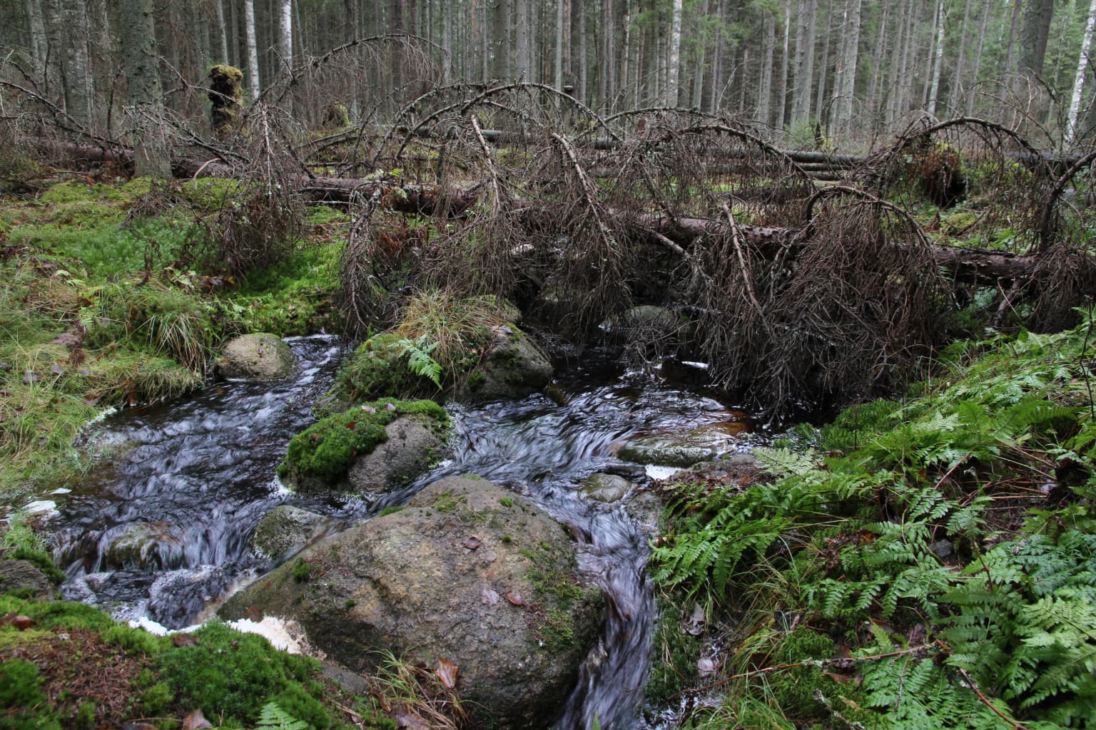
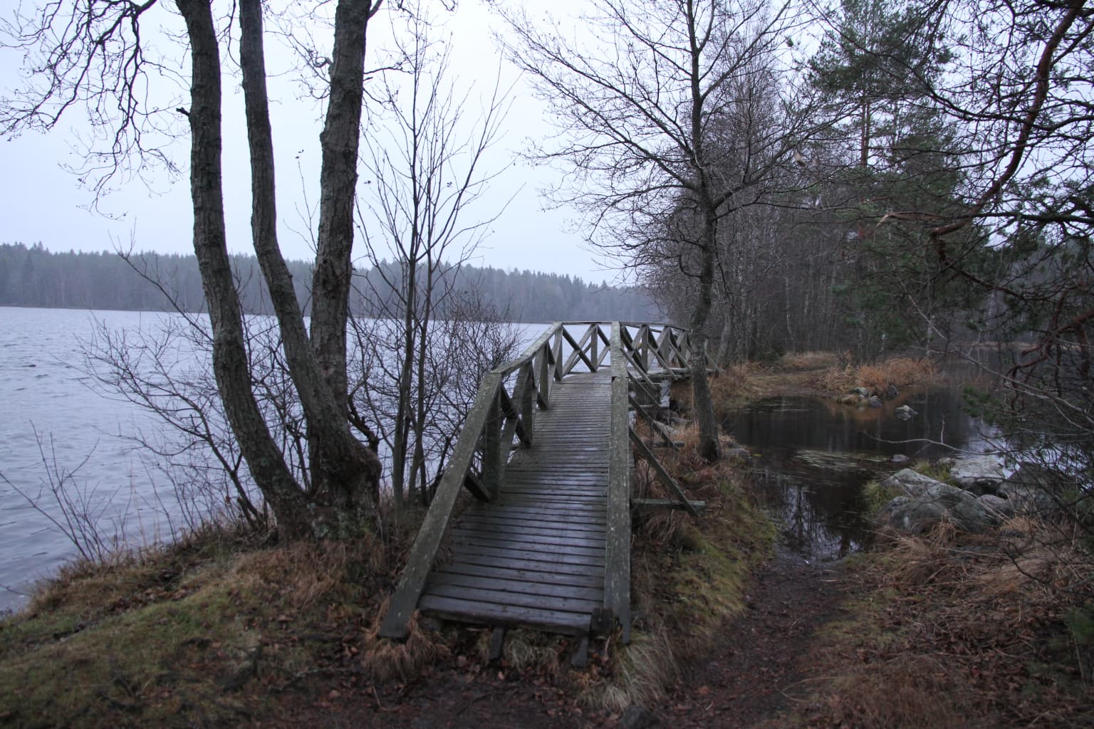
The landscape of Liesjärvi National Park exemplifies the classic lake-highland terrain of the Häme region in southern Finland. The terrain is characterised by gently undulating hills, glacial ridges, and a network of lakes, ponds, and wetlands that create a diverse mosaic of habitats. The park sits on the lie of the land in a region known for its abundant water bodies and forested hills. Kyynäränharju stands out as a notable ridge feature, offering elevated views over the surrounding lake landscape. The park contains extensive shoreline, with nearly 50 kilometres of water edge along its various lakes and ponds. Forest types range from dense, old-growth spruce-dominated forests to more open pine heaths on drier ridge sites. Wetland mires add further diversity to the terrain. While Liesjärvi lake itself lies just outside the park boundary, its islands are included in the protected area. The Korteniemen area represents a cultural landscape element, with its traditional farmstead setting contrasting with the surrounding natural terrain.

Wooden plank bridge crossing a stream with Liesjärvi Lake in the background and forested shoreline
Wooden walking bridge at Kyynäränjuova, Liesjärvi National Park with Liesjärvi Lake visible to the left

Liesjärvi National Park ecosystems, habitats, and plant life

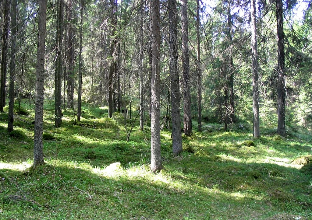
The nature of Liesjärvi National Park encompasses a remarkable diversity of forest and habitat types within a relatively compact area. The park protects old-growth spruce forests that represent some of the best examples of near-natural forest in southern Finland, with some of the oldest trees in the park reaching ages of 180 years. Open pine-dominated heaths occur on the drier ridge sites, while wetland mires fill the depressions between hills. The forest guard station at Korteniemen has been deliberately maintained to preserve cultural landscape elements that would otherwise disappear, including traditional habitats associated with rural land use. The aquatic environment includes the islands of Liesjärvi lake, adding to the habitat diversity. The park's position in the lake-highland zone of Häme places it in an ecological region characterised by the mixing of boreal and more southern influences, creating conditions that support a range of species and community types.

Tall coniferous trees with mossy ground in a forested area
Moss-covered forest floor with tall coniferous trees in Liesjärvi National Park

Liesjärvi National Park wildlife and species highlights

Liesjärvi National Park supports wildlife populations typical of southern Finnish boreal forests, with the diverse habitat mosaic providing conditions for a variety of species. The old-growth spruce forests host species associated with decaying wood, including various fungi and invertebrates that require veteran trees. The wetland areas attract waterfowl and provide breeding habitat for birds associated with marsh and bog environments. The shoreline areas along the park's numerous lakes and ponds offer feeding and nesting opportunities for waterbirds. The cultural landscape around Korteniemen, with its traditional practices, maintains open habitats that support different species assemblages than the closed forests. The broader Häme Ilvesreitistö network that the park participates in creates connectivity for wildlife movement through the forested landscape.

Liesjärvi National Park conservation status and protection priorities

Liesjärvi National Park represents an important conservation designation in southern Finland, protecting representative examples of the lake-highland landscape that has been extensively modified in this densely populated region. The early protection of old-growth forest areas at Ahonnokan and Isosaari in 1929 predates the national park designation itself, demonstrating the long-standing recognition of the area's ecological value. The park protects habitat types that have become scarce in the surrounding agricultural and forested landscape, including old-growth forests, wetlands, and the cultural environments associated with traditional land management. The integration of Korteniemen perinnetila into the protected area represents a thoughtful approach to conserving both natural and cultural heritage, maintaining traditional practices and the landscape elements they create. The park's proximity to Finland's most populated region underscores the importance of preserving accessible natural environments for both ecological and recreational purposes.

Liesjärvi National Park cultural meaning and human context

The cultural context of Liesjärvi National Park is strongly represented by Korteniemen perinnetila, the historic forest guard station that forms a living window into early 20th-century rural life in southern Finland. This site represents the only forest guard station in Southern Finland to have preserved its original yard layout, and it has been carefully restored to reflect its appearance from the 1910s. Archaeological evidence indicates human presence in the area since the Stone Age, with prehistoric settlement evidence found at Korteniemen. Later historical use included slash-and-burn agriculture and tar production, important industries in Finland's forest history. The tar production left visible traces, with multiple historic tar kiln sites still present at Korteniemen. The area came under state control in 1878 and was managed as Crown forest land with a dedicated forest guard. The park maintains this heritage through public events and open access from May through October, offering visitors a tangible connection to the region's rural past.

Top sights and standout views in Liesjärvi National Park

Liesjärvi National Park's standout features include the ancient forests of Ahonnokka, where trees up to 180 years old create a primeval forest atmosphere, and the historic Korteniemen perinnetila where visitors can experience traditional agricultural work and explore a preserved forest guard station from the 1910s. The scenic Kyynäränharju ridge provides panoramic views over the lake-highland landscape, while the park's nearly 50 kilometres of shoreline and diverse trail network offer extensive exploration opportunities. The integration into the 200-kilometre Häme Ilvesreitistö trail system makes the park a gateway to broader wilderness experiences in the region. With visitor numbers around 57,000 annually and location less than 100 kilometres from Helsinki, the park serves as an important accessible wilderness area for southern Finland's population.

Best time to visit Liesjärvi National Park

Liesjärvi National Park can be visited throughout the year, with each season offering distinct experiences. The summer months from May to October bring the most accessibility, with all facilities including Korteniemen perinnetila open to visitors. Summer offers warm weather for hiking the approximately 30 kilometres of marked trails, with long daylight hours allowing extended exploration. The autumn months bring changing forest colours and quieter trails as the peak summer season ends. Winter offers a different character across the snow-covered landscape, though facilities are more limited. The park's relatively small size and developed trail network make it suitable for day visits, while its integration into longer trail systems supports multi-day explorations. The proximity to Helsinki means the park can be easily accessed for weekend getaways throughout the year.

Park location guide

Geography guide, regional context, and park location map for Liesjärvi National Park

Liesjärvi National Park park geography, regions, and map view in Finland
Understand where Liesjärvi National Park sits in Finland through a broader geographic reading of the surrounding landscape, nearby location context, and its mapped position within the national park landscape.

How Liesjärvi National Park fits into Finland

Finland, officially the Republic of Finland, is a Nordic country in Northern Europe with a population of 5.6 million. It borders Sweden, Norway, and Russia, with the Gulf of Bothnia to the west and the Gulf of Finland to the south. The country gained independence from Russia in 1917 and is a unitary parliamentary republic. Its landscape is characterized by extensive boreal forests and over 180,000 lakes.

Wider geography shaping Liesjärvi National Park in Finland

Finland is located in Northern Europe, occupying a peninsula bordered by the Gulf of Bothnia to the west and the Gulf of Finland to the south. It shares land borders with Sweden to the northwest, Norway to the north, and Russia to the east. The terrain is predominantly flat with extensive forest coverage and numerous lakes.

Map view of Liesjärvi National Park

Use this park location map to pinpoint Liesjärvi National Park in Finland, understand its exact geographic position, and read its mapped placement within the surrounding landscape more clearly.

Pigeon | © OpenStreetMap contributors

Location context for Liesjärvi National Park

Kanta-Häme

Explore Liesjärvi's Diverse Scenery, Pristine Habitats, and Lake-Highland Terrain Through Detailed Protected Area Imagery

Liesjärvi National Park Photos: Visual Guide to Finland's Ancient Forests and Lake Landscapes
Visually explore Liesjärvi National Park, a Finnish protected area known for its ancient spruce forests, extensive lake-highland terrain, and unique wetland mires. The detailed imagery helps identify specific habitats, map the park's varied landscapes, and understand its distinctive conservation character within the Häme region.

A stream flows through a forested area with moss-covered rocks and fallen branches

A person hiking on a wooden boardwalk through a forest with tall pine trees and a lake visible in the background

Wooden plank bridge crossing a stream with Liesjärvi Lake in the background and forested shoreline

Tall coniferous trees with mossy ground in a forested area

Park atlas

Map the surrounding protected landscapes of southern Finland, tracing boreal forests, lake-highland terrain, and wetlands for broader park comparison.

Discover More National Parks and Protected Areas Surrounding Liesjärvi National Park
After exploring Liesjärvi National Park, continue your geographic discovery by browsing an organized list of nearby national parks and other protected areas across southern Finland. This structured view allows you to compare diverse landscapes, from ancient forests to wetlands, providing a comprehensive understanding of regional conservation efforts and connected park geography.
Watercolor illustration of a landscape featuring a body of water, trees, and distant mountains
National parkKanta-Häme

Torronsuo National Park: Explore Finland's Exceptional Raised Bog Ecosystem and Kanta-Häme Geography

Discover mapped peatlands, unique birdlife, and protected boreal wilderness.

Torronsuo National Park stands as a testament to Finland's remarkable wetland conservation efforts, presenting a striking example of a raised bog ecosystem. Located within the Kanta-Häme region, this national park is celebrated for its vast, domed peat landscape, some of the thickest peat layers ever measured in Finland, and its status as a Ramsar-designated wetland. The park's protected status ensures the preservation of its unique natural terrain, which supports a rich diversity of northern bird species and specialized bog flora, making it a significant area for ecological and geographic exploration.

Area
25.5 km²
Established
1990
IUCN
II
Visitors
58.6K annual
National parkUusimaa

Nuuksio National Park: Uusimaa Region Protected Landscape Atlas Entry

Mapped boundaries and geographic context for a Finnish National Park.

Access detailed geographic information and mapped boundaries for Nuuksio National Park, a protected national park within the Uusimaa region. This MoriAtlas entry provides context for understanding its landscape within Finland, focusing on atlas-style exploration and the identification of protected natural areas.

Area
53 km²
Established
1994
IUCN
II
Visitors
312.6K annual
National parkSouthwest Finland

Teijo National Park: Mapped Boundaries of a Protected National Park in Southwest Finland

Explore the geographic context and protected landscape of Teijo National Park.

Teijo National Park is a designated national park within Southwest Finland, offering a distinct protected landscape for atlas exploration. This entry focuses on its geographic identity, mapped park boundaries, and its place within the broader regional geography. Discover the structured details of Teijo National Park as a key protected area, providing valuable context for understanding natural landscapes and conservation efforts in Finland.

Area
34 km²
Established
2015
IUCN
II
Visitors
92.1K annual
Watercolor painting showing green hills, trees, and a stream in a landscape
National parkSouthwest Finland

Kurjenrahka National Park: Southwest Finland's Protected Landscape Atlas Entry

Discover geographic context and park boundaries.

Delve into Kurjenrahka National Park, a designated national park situated in Southwest Finland. This page provides an atlas-focused view of the park, detailing its protected landscape identity, mapped terrain, and its specific geographic location within the broader Finnish region. Understand the park's ecological context and its significance as a key protected area for regional geographic exploration.

Area
29 km²
Established
1998
IUCN
II
Visitors
66.8K annual
Watercolor illustration showing green trees, a river, and rolling hills under a soft sky
National parkUusimaa

Sipoonkorpi National Park: Protected Landscape and Geography in Uusimaa

Explore Finland's key national park and its natural terrain.

Discover Sipoonkorpi National Park, a vital protected landscape in Finland's Uusimaa region. This page offers detailed insight into its mapped boundaries, diverse boreal forests, extensive swamp areas, and the unique terrain that defines this significant natural area. Understand its role as one of the last undeveloped green spaces near the Helsinki metropolitan area and explore its geographic context within southern Finland.

Area
18.57 km²
Established
2011
IUCN
II
Visitors
165.5K annual
National parkPirkanmaa

Puurijärvi-Isosuo National Park: Protected Landscape Discovery in Pirkanmaa Region

Explore mapped protected areas and regional geography.

Puurijärvi-Isosuo National Park is a significant protected area in Finland's Pirkanmaa region. This entry provides detailed geographic context and maps the park's boundaries, offering a focused perspective for atlas-driven discovery of Finnish natural landscapes. Understand its place within the regional geography and the wider network of protected lands.

Area
27 km²
Established
1993
IUCN
II
Visitors
19.8K annual
National parkUusimaa

Ekenäs Archipelago National Park: Mapped Baltic Sea Archipelago Landscape

Protected marine area with island geography in Uusimaa, Finland.

Delve into the unique protected landscape of Ekenäs Archipelago National Park, a premier example of a Baltic Sea marine protected area. Located in the Uusimaa region, this national park encompasses a vast expanse of coastal waters dotted with hundreds of rocky islets and skerries. MoriAtlas provides detailed geographic context, allowing for exploration of its mapped boundaries, island formations, and critical role as a sanctuary for breeding aquatic birds. Understand its place within Finland's protected areas atlas and appreciate its distinctive marine archipelago character.

Area
52 km²
Established
1989
IUCN
II
Visitors
53.6K annual
National parkPäijät-Häme

Päijänne National Park: Mapped Island Archipelago in Finland's Päijät-Häme Region

Explore unique glacial geology and boreal island wilderness.

Päijänne National Park presents a compelling protected landscape for atlas discovery, focusing on its distinct archipelago character within Lake Päijänne, Southern Finland. This national park features numerous islands showcasing ancient geological formations, from rocky outcrops to sandy beach ridges and moraine formations. Its mapped terrain offers insights into glacial processes and the development of boreal island ecosystems. Navigate its unique island settings to understand the geographic context of this protected area in the Päijät-Häme region.

Area
14 km²
Established
1993
IUCN
II
Visitors
67K annual

Common questions about visiting, size, designation, and location context for Liesjärvi National Park

Liesjärvi National Park FAQs for park facts, access, geography, and protected area context
Find quick answers about Liesjärvi National Park, including protected-area facts, park geography, trail and visitor context, and how the park fits into its surrounding country and regional landscape.
MoriAtlas Explorer

Continue Your Protected Areas Search Across the Global Atlas

Deepen your exploration by continuing the structured search for national parks and protected areas worldwide. Utilize the comprehensive filtering capabilities to compare different conservation landscapes and refine your understanding of global park geography. Discover more about the distribution and characteristics of protected natural areas.

Global natural geography