Mori Atlas logo
Nature reserveLiffey Valley Reserve

Mapping the vegetation gradients and elevation-driven terrain of the Great Western Tiers

Liffey Valley Reserve Nature Reserve: A Mapped Analysis of Tasmania Protected Landscapes

Liffey Valley Reserve encompasses four distinct parcels of land that trace the steep relief of the Great Western Tiers in northern Tasmania. This protected area serves as a vital ecological corridor, mapping a rare compression of vegetation types from alpine heath down through tall sclerophyll forests to sheltered temperate rainforests. The reserve represents a core study in elevation-driven biodiversity and protected landscape continuity within the Meander River catchment.

nature reserveTasmaniasclerophyll foresttemperate rainforestalpine heathGreat Western Tiers

Liffey Valley Reserve

Nature reserve

Park overview

Structured park overview, official facts, and landscape profile for Liffey Valley Reserve

Liffey Valley Reserve park facts, protected area profile, and essential visitor context

Review the core facts for Liffey Valley Reserve, including designation, size, terrain, visitor scale, habitats, and operating context in one park-focused overview.

About Liffey Valley Reserve

Liffey Valley Reserve is a 275-hectare nature reserve operated by Bush Heritage Australia in the northern midlands region of Tasmania. Rather than a single contiguous block of forest, the reserve is a mosaic of four separate parcels strung along the Liffey Valley and its tributaries, where the catchment of the Meander River descends from the high wall of the Great Western Tiers.

The defining characteristic of the reserve is the steep environmental gradient it captures. In a relatively short horizontal distance, the land drops from the exposed plateau edge of the Tiers down through tall eucalypt forest into sheltered valleys. This vertical variation produces a striking diversity of vegetation types, from alpine heath and buttongrass moorland communities at the top of the escarpment to drier eucalypt forest on the mid-slopes, and eventually to the cool, damp shade of temperate rainforest in the deeper gullies.

Ecologically, the reserve functions as an important refuge for native forest in a landscape that has historically been heavily modified for agriculture and forestry. By holding four separate parcels, it protects not just a single forest type but a connected set of habitats that together sustain populations of mammals and birds reliant on mature forest, intact riparian corridors, and adjacent high-country vegetation.

Beyond its ecological role, the reserve has a place in Australian conservation history. It began as a pair of private land purchases made to keep native forest out of the chainsaw, and those purchases evolved into one of the country's most prominent private conservation organizations. The reserve is therefore both an active conservation property and a foundational chapter in the modern private-land conservation movement in Australia.

Quick facts and research context for Liffey Valley Reserve

Liffey Valley Reserve is a privately owned nature reserve of about 275 hectares in northern Tasmania, made up of four non-contiguous parcels in the catchment of the Meander River. It is located in the Liffey Valley, roughly 55 kilometres south-west of Launceston and south-east of Deloraine, beneath the cliffs of the Great Western Tiers.

The reserve is owned and managed by Bush Heritage Australia, and its component blocks were originally purchased in the early 1990s to shield native forests from logging. The land spans an elevation gradient from mid-altitude eucalypt forest to temperate rainforest gullies and high-elevation heath.

Park context

Deeper park guide and search-rich context for Liffey Valley Reserve

Liffey Valley Reserve history, landscape, wildlife, and travel context

Explore Liffey Valley Reserve through its history, landscape character, ecosystems, wildlife, conservation priorities, cultural context, and seasonal travel timing in a structured park guide built for atlas discovery and search intent.

Why Liffey Valley Reserve stands out

Liffey Valley Reserve is best known for compressing an unusually complete Tasmanian vegetation sequence into a small reserve, ranging from alpine heath on the Great Western Tiers down through wet and dry sclerophyll forest into temperate rainforest gullies. It is also strongly associated with threatened and emblematic Tasmanian wildlife, including Tasmanian devils, platypus and wedge-tailed eagles. The reserve is historically notable as the founding estate of Bush Heritage Australia, giving it a symbolic role in Australian private conservation as well as an ecological one.

Liffey Valley Reserve history and protected-area timeline

Liffey Valley Reserve began as a direct response to the threat of logging in the upper Liffey Valley. In 1990, two parcels known as Liffey River and Dry's Bluff were purchased in order to prevent their native forests from being harvested. A third parcel, Coalmine Creek, was acquired around the same time for much the same reason.

Those early purchases were channelled into a newly formed conservation entity, the Australian Bush Heritage Fund, which today operates as Bush Heritage Australia. Liffey Valley Reserve was effectively the founding estate of that organization. Coalmine Creek was later donated to Bush Heritage Australia in 2003, and the fourth parcel, Oura Oura, was added in 2011 through donation, completing the present four-parcel configuration of the reserve.

The trajectory of the reserve, from individual land purchase in response to a logging threat to a multi-parcel conservation estate managed by a national land trust, mirrors the broader development of private conservation in Australia during the late twentieth and early twenty-first centuries.

Liffey Valley Reserve landscape and geographic character

The Liffey Valley sits on the western side of northern Tasmania's central highlands, in the catchment of the Meander River. The valley's defining feature is the wall of the Great Western Tiers, a long escarpment that rises sharply above the surrounding lowlands. Within a roughly ten kilometre horizontal span, the terrain in this part of the catchment drops from around 1,200 metres above sea level at the plateau edge down to about 400 metres in the valley below, producing some of the steepest and most visually dramatic relief in northern Tasmania.

Within the reserve's four parcels, this gradient is expressed as a sequence of landforms. Exposed ridge lines and plateau margins carry stunted, wind-shaped vegetation, while the mid-slopes are dominated by tall eucalypt forest. Steeper, sheltered gullies broaden into damp, mossy depressions where the climate cools and rainfall accumulates, allowing temperate rainforest to persist. Rocky creek lines and small tributaries thread through the valley, linking the high country to the broader Meander catchment.

Liffey Valley Reserve ecosystems, habitats, and plant life

The vegetation of Liffey Valley Reserve is shaped by the same elevation gradient that defines the landscape. At the highest elevations on the reserve, alpine heath communities reflect the harsh, exposed conditions near the cliff edge of the Great Western Tiers. These low, hardy shrublands give way downslope to extensive stands of wet sclerophyll forest, where tall eucalypts rise above a dense understorey that thrives on the high rainfall and fertile soils of the mid-slopes.

Drier aspects and sheltered ridges carry dry sclerophyll forest, a more open eucalypt woodland adapted to lower soil moisture and greater exposure. In the deepest, most sheltered gullies, conditions cool and moisten enough to support temperate rainforest, one of Tasmania's most ecologically distinctive vegetation types. These rainforest patches, with their mixed canopy of myrtle beech, sassafras and other moisture-loving species, form small but biologically rich islands within the broader eucalypt forest matrix.

Together, these vegetation types create a layered habitat structure that supports a wide range of animal species and gives the reserve a strong representative value for Tasmanian temperate forest ecosystems.

Liffey Valley Reserve wildlife and species highlights

The mammals of Liffey Valley Reserve include some of Tasmania's most characteristic species. Tasmanian devils inhabit the forested landscape, while platypuses are present along the reserve's waterways. The reserve also supports smaller native mammals such as bandicoots, bettongs, potoroos, and pygmy possums; these small, ground-dwelling animals are particularly sensitive to habitat fragmentation and forest disturbance, so their presence is a useful indicator of the reserve's ecological condition.

Birdlife is similarly varied. The reserve hosts threatened Tasmanian wedge-tailed eagles, a subspecies found only on the island, along with pink robins in the damper forested areas and yellow-tailed black-cockatoos. Raptors, parrots and small forest passerines together contribute to a rich and seasonally dynamic bird community across the reserve's elevation gradient.

Liffey Valley Reserve conservation status and protection priorities

Liffey Valley Reserve matters for conservation both because of what it protects and because of how it was protected. Ecologically, it safeguards a continuous vegetation sequence from alpine heath through wet and dry sclerophyll forest to temperate rainforest, a combination that is increasingly rare in landscapes altered by agriculture and forestry. The presence of threatened species such as the Tasmanian wedge-tailed eagle, along with mammals sensitive to habitat change such as Tasmanian devils and small marsupials, elevates its conservation significance.

Equally important is its institutional significance. The reserve was among the first private properties placed under the management of Bush Heritage Australia, and its establishment helped demonstrate that private land acquisition could be an effective tool for protecting native forest at a landscape scale. By maintaining four distinct parcels, the reserve contributes to connectivity and habitat representation in a region where forest cover has otherwise been heavily reduced.

Liffey Valley Reserve cultural meaning and human context

The reserve's name, Dry's Bluff, carries a Tasmanian Aboriginal name in parentheses: Taytitikitheeker, a transliterated form reflecting the Aboriginal heritage of the broader Liffey Valley landscape. This recognition connects the modern conservation property to the long Aboriginal history of the region, even as the reserve itself is defined by its recent history of private acquisition and ecological management.

Top sights and standout views in Liffey Valley Reserve

Liffey Valley Reserve stands out for the way it condenses a multi-elevation Tasmanian vegetation sequence into a single connected set of reserves, from alpine heath at the top to temperate rainforest in the sheltered valleys. It protects habitat for threatened species such as the Tasmanian wedge-tailed eagle, Tasmanian devils and platypus, while also sheltering smaller ground-dwelling mammals like bettongs and potoroos that are vulnerable to forest disturbance.

Its status as the founding reserve of Bush Heritage Australia adds an institutional and historical layer to its ecological value, making it both a working conservation property and a touchstone in the history of private land conservation in Australia.

Best time to visit Liffey Valley Reserve

Tasmania's Liffey Valley experiences cool temperatures and reliable rainfall year-round, with winter bringing colder conditions and shorter days at higher elevations, and summer offering warmer, longer days and better access to forest walking. Spring and early summer tend to be particularly rewarding for observing mature wet forest and rainforest gullies at their greenest, while autumn can provide quieter conditions for birdwatching across the sclerophyll forest. Visitors should generally expect changeable mountain weather regardless of season, because the reserve sits directly beneath the steep wall of the Great Western Tiers.

Monthly climate preview

Long-term monthly temperature averages and precipitation records for Tasmania

Liffey Valley Reserve Climate Normals, Annual Temperature and Precipitation Patterns

Liffey Valley Reserve displays a measured annual rhythm of monthly temperature ranges and precipitation rates recorded between 1991 and 2020. Examining the complete twelve-month dataset reveals full monthly temperature variations and precipitation totals for this location.
Annual mean11 °C
6 °C17 °C
Jan17°
Feb17°
Mar15°
Apr11°
May
Jun
Jul
Aug
Sep
Oct10°
Nov12°
Dec15°
Warmest month
January

17 °C

Coolest month
July

6.3 °C

Wettest month
August

3.5 mm/day

Driest month
February

1.6 mm/day

Park location guide

Geography guide, regional context, and park location map for Liffey Valley Reserve

Liffey Valley Reserve park geography, regions, and map view in Australia

Understand where Liffey Valley Reserve sits in Australia through a broader geographic reading of the surrounding landscape, nearby location context, and its mapped position within the national park landscape.

How Liffey Valley Reserve fits into Australia

Australia is a constitutional monarchy and federal parliamentary democracy comprising six states and ten territories. With a population of nearly 28 million, it is one of the world's most urbanised countries, with most people concentrated on the eastern seaboard. The country has a high Human Development Index and is known for its cultural diversity, ancient Aboriginal heritage, and unique wildlife.

Wider geography shaping Liffey Valley Reserve in Australia

Australia occupies the entire Australian continent, the island of Tasmania, and numerous smaller islands. It is the world's flattest and driest inhabited continent, featuring vast deserts in the interior (the Outback), tropical rainforests along the eastern coast, and a coastline bordering the Indian and Pacific Oceans.

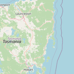
Map view of Liffey Valley Reserve

Use this park location map to pinpoint Liffey Valley Reserve in Australia, understand its exact geographic position, and read its mapped placement within the surrounding landscape more clearly.

Pigeon | © OpenStreetMap contributors

Location context for Liffey Valley Reserve

Tasmania
Park atlas

Compare regional protected landscapes across the northern Tasmanian catchment.

Exploring Parks Near Liffey Valley Reserve and Surrounding Protected Areas

Browsing other protected areas near Liffey Valley Reserve reveals connected vegetation gradients along the Great Western Tiers. Comparing nearby reserves provides broader geographic context for the surrounding northern Tasmanian river catchments.
National parkTasmania
About 35 km away#1 closest

West

Mole Creek Karst National Park: Mapped Protected Area and Tasmanian Landscape Atlas

Explore the geography and park boundaries within Tasmania's protected lands.

Mole Creek Karst National Park stands as a key protected area within Tasmania, offering a unique glimpse into the island state's natural geography. This resource facilitates an atlas-style discovery of the park's mapped landscape, its protected boundaries, and its significance within the broader context of Australian protected lands. Understand the park's terrain and its role in the region's conservation heritage.

Area
13.45 km²
Established
1996
IUCN
II
Relief
Mountain
National parkTasmania
About 38 km away#2 closest

Southwest

Walls of Jerusalem National Park: A Mapped Alpine Wilderness in Tasmania

Explore protected landscapes with biblical place names.

Walls of Jerusalem National Park in Tasmania is a distinguished national park characterized by its rugged alpine terrain and dramatic quartzite formations, most notably King Davids Peak. The park's landscape is further distinguished by a unique series of features named after biblical locations, offering an evocative exploration for those interested in geographic discovery. As a protected wilderness area within the Tasmanian Wilderness World Heritage Area, it provides valuable insight into Australia's significant natural landscapes and their mapped representation.

Area
518 km²
Established
1978
IUCN
II
Relief
Mountain
National parkTasmania
About 53 km away#3 closest

West

Cradle Mountain, Lake St Clair National Park: Tasmania's Mapped Protected Landscape and Geography

Explore national park boundaries and regional natural terrain.

Gain insight into Cradle Mountain, Lake St Clair National Park, a protected national park in Tasmania, Australia. This entry provides a foundational understanding of its mapped terrain, geographic setting, and protected area status. Delve into the specific landscape characteristics that define this significant conservation zone and its place within the national atlas.

Area
1,614.43 km²
Established
1922
IUCN
II
Visitors
209K annual
National parkTasmania
About 60 km away#4 closest

North

Narawntapu National Park: Tasmania's Coastal Protected Landscape and Wildlife Atlas

Explore mapped boundaries, heathland, woodland, and intertidal bird habitats.

Narawntapu National Park showcases a remarkable protected coastal landscape on Tasmania's north coast, renowned for its exceptional density of marsupial wildlife and significant intertidal bird populations. Its diverse terrain, including heathland, woodland, and extensive mudflats, offers unique opportunities for geographic discovery and understanding the park's ecological importance. Examine its mapped natural features and protected status within the broader atlas of Australian reserves.

Area
43.49 km²
Established
1976
IUCN
II
Visitors
10.1K annual
Watercolor illustration showing a lake with distant mountains and vegetation
National parkAustralia
About 63 km away#5 closest

East

Ben Lomond National Park: Tasmania's Premier Alpine Protected Landscape & Geography

Explore unique dolerite geology, plateau scenery, and alpine ecosystems.

Ben Lomond National Park is a premier alpine protected area within Australia, known for its dramatic dolerite geology and extensive plateau terrain. This national park offers a distinct mountain landscape shaped by glacial history, featuring notable peaks and significant alpine ecosystems. Discover the mapped boundaries and regional geographic context of this unique Australian protected land, understanding its place within the broader atlas of natural landscapes.

Area
162 km²
Established
1947
IUCN
II
Relief
Mountain
National parkTasmania
About 98 km away#6 closest

South

Mount Field National Park: Explore Tasmania's Protected Landscape and Geographic Identity

Mapped terrain and regional atlas context for this Australian national park.

Mount Field National Park serves as a cornerstone of protected natural landscapes in Tasmania, Australia. This entry provides detailed geographic context, focusing on its mapped boundaries and distinct environmental setting. Users can explore its identity as a national park, understand its regional placement within Tasmania, and gain insight into the mapped terrain that defines this significant protected area. It is designed for atlas-based discovery of the park's landscape characteristics.

Area
162.65 km²
Established
1916
IUCN
II
Relief
Mountain
National parkTasmania
About 103 km away#7 closest

Southwest

Franklin, Gordon Wild Rivers National Park: Mapped Protected Landscape Identity in Tasmania's Geography

Explore the mapped boundaries of this Tasmanian National Park.

Franklin, Gordon Wild Rivers National Park stands as a testament to Tasmania's commitment to preserving its natural heritage. This national park provides a unique opportunity to examine protected land boundaries and understand its specific geographic setting within the Australian state. Its landscape context is integral to the regional atlas, offering a clear representation of conservation priorities and natural geographic features for detailed study.

Area
4,463.42 km²
Established
1908
Relief
Mountain
Climate
Temperate
Watercolor illustration of a landscape featuring hills, trees, and a winding river
National parkTasmania
About 109 km away#8 closest

East

Douglas-Apsley National Park: Discover its Protected Landscape and Geographic Context in Tasmania

Mapped boundaries and regional terrain of a key Tasmanian national park.

Delve into the geographic details of Douglas-Apsley National Park, a designated national park situated in Tasmania, Australia. This entry provides insight into the park's protected landscape identity, its mapped boundaries, and its contribution to the rich regional geography of Tasmania. Understanding its place within the island's natural terrain is crucial for comprehensive atlas-driven exploration and appreciating Australia's protected areas.

Area
160.8 km²
Established
1989
IUCN
II
Relief
Upland

Common questions about visiting, size, designation, and location context for Liffey Valley Reserve

Liffey Valley Reserve FAQs for park facts, access, geography, and protected area context

Find quick answers about Liffey Valley Reserve, including protected-area facts, park geography, trail and visitor context, and how the park fits into its surrounding country and regional landscape.
MoriAtlas Explorer

Continue Your Protected Areas Search Across the Global Atlas

Deepen your exploration by continuing the structured search for national parks and protected areas worldwide. Utilize the comprehensive filtering capabilities to compare different conservation landscapes and refine your understanding of global park geography. Discover more about the distribution and characteristics of protected natural areas.

Global natural geography