

Mori Atlas logo
National parkMole Creek Karst National Park

Discover the mapped boundaries and regional landscape context of this Tasmanian national park.

Mole Creek Karst National Park: Tasmania's Protected Landscape and Geographic Atlas

Mole Creek Karst National Park represents a significant protected landscape within Tasmania, Australia's island state. This page offers an atlas-driven exploration of the park's geographic identity, detailing its mapped boundaries and its place within the region's natural terrain. Understand the park's protected area context and its contribution to Tasmania's renowned conservation landscapes.

karst landscapecave systemsglow wormstroglobite speciesWorld Heritage Areashow caves

Mole Creek Karst National Park

National park

Park overview

Structured park overview, official facts, and landscape profile for Mole Creek Karst National Park

Mole Creek Karst National Park park facts, protected area profile, and essential visitor context
Review the core facts for Mole Creek Karst National Park, including designation, size, terrain, visitor scale, habitats, and operating context in one park-focused overview.

About Mole Creek Karst National Park

Mole Creek Karst National Park represents one of Tasmania's most geologically and biologically significant protected areas, created specifically to preserve a unique karst landscape that cannot be found anywhere else in the state. The park sits on the eastern slopes of the Great Western Tiers, a mountain range that forms part of the ancient geological foundation of Tasmania. The karst system beneath this landscape has developed over millions of years as acidic groundwater gradually dissolved the limestone bedrock, creating an extensive network of caves, passages, sinkholes, and underground streams.

The park's twelve land blocks are interspersed with private agricultural land, creating management challenges as many significant cave entrances and karst features lie outside the protected boundary. This fragmented landscape requires careful coordination with neighboring landowners to ensure the integrity of the broader karst system. The area's significance extends far beyond its surface appearance, as the underground environment contains a complex ecosystem that has evolved in complete isolation from the outside world.

As part of the Tasmanian Wilderness World Heritage Site, the park contributes to the protection of one of the world's last great temperate wilderness areas. The World Heritage designation recognizes both cultural and natural values, with the area meeting criteria related to outstanding universal value in terms of geological processes, ecological systems, and biodiversity. The park attracts visitors from around the world who come to experience the subterranean wonders, with guided cave tours providing access to the most spectacular chambers while minimizing impact on the sensitive underground environment.

Quick facts and research context for Mole Creek Karst National Park

Mole Creek Karst National Park covers 13.45 square kilometers in northern Tasmania, Australia. Established in 1996, it is the only national park in Tasmania specifically created to protect karst landforms. The park contains over 300 known caves and sinkholes, with King Solomons Cave and Marakoopa Cave developed as show caves. The park is part of the Tasmanian Wilderness World Heritage Site and is classified as an IUCN Category II protected area. The surrounding forests are dominated by various eucalyptus species including brown-top stringybark, white-top stringybark, swamp gum, and black gum.

Park context

Deeper park guide and search-rich context for Mole Creek Karst National Park

Mole Creek Karst National Park history, landscape, wildlife, and travel context
Explore Mole Creek Karst National Park through its history, landscape character, ecosystems, wildlife, conservation priorities, cultural context, and seasonal travel timing in a structured park guide built for atlas discovery and search intent.

Why Mole Creek Karst National Park stands out

Mole Creek Karst National Park is best known for its spectacular underground cave systems and the rare cave-dwelling species that inhabit them. The park's Marakoopa Cave features one of the most impressive glow worm displays in Tasmania, with the bioluminescent larvae of Arachnocampus tasmaniensis creating a starry night effect on the cave ceilings. King Solomons Cave is renowned for its elaborate speleothem formations including flowing shawls, stalactites, and stalagmites, as well as sediment and bone deposits. Beyond the show caves, the park protects an exceptional collection of troglobite species that have evolved entirely within the cave environment, including the rare cave beetle Tasmanotrechus cockerilli, the Mole Creek Cave Pseudoscorpion, and the Mole Creek Cave Harvestman, all of which are endemic to this specific karst system.

Mole Creek Karst National Park history and protected-area timeline

Mole Creek Karst National Park was officially declared in 1996, making it one of Tasmania's more recently established national parks. The creation of the park represented a significant step in the protection of Tasmania's unique karst resources, as it was the first and remains the only national park in the state established specifically to protect karst landforms. Prior to formal protection, the cave systems had been known to local communities and researchers for decades, with exploratory work documenting the extent and significance of the underground network.

The establishment of the park came after growing recognition of the need to protect the cave systems and their unique biological inhabitants. The karst environment faces particular vulnerability due to its geological nature, where impacts to one part of the system can affect underground connections throughout the network. The parks and wildlife management authorities worked to consolidate the twelve separate land blocks that now comprise the national park, creating a protected framework that acknowledges the above-ground components while working to coordinate conservation of the broader underground system.

King Solomons Cave and Marakoopa Cave were developed as show caves prior to the national park's formal establishment, with infrastructure installed to allow guided access while protecting the sensitive cave environments. These show caves remain the primary attractions for visitors and provide important revenue that supports ongoing conservation and management activities within the park.

Mole Creek Karst National Park landscape and geographic character

The landscape of Mole Creek Karst National Park is defined by the interaction between surface terrain and the extraordinary underground karst system that lies beneath. The park occupies the lower slopes of the Great Western Tiers, a mountain range that forms part of Tasmania's central highlands. The surface terrain varies from gentle slopes to more steeply pitched areas, with the underlying limestone bedrock creating distinctive karst topography including sinkholes, vertical shafts, and resurgences where underground streams re-emerge.

The twelve discrete blocks that comprise the national park are interspersed with cleared agricultural land, creating a patchwork landscape where the protected areas sit within a broader rural setting. Within the park boundaries, the vegetation ranges from dense eucalyptus forest to more open areas that have been affected by historical fire regimes and grazing pressure. Many sinkholes within the park are associated with Sphagnum peatlands that develop in the depressions, adding wetland character to portions of the landscape.

The cave systems themselves represent the most dramatic landscape feature, with some passages extending for considerable distances beneath the surface. The Marakoopa Cave contains two underground streams, large caverns, rim pools, and the flowstone and shawl formations that characterize limestone caves. King Solomons Cave features extensive sediment deposits and impressive speleothem formations. The caves maintain a stable microclimate that differs dramatically from the surface environment, with constant temperatures and high humidity supporting the specialized cave-dwelling organisms.

Mole Creek Karst National Park ecosystems, habitats, and plant life

The ecological systems within Mole Creek Karst National Park encompass both surface forests and the unique underground cave environment, each supporting distinct communities of organisms adapted to their respective conditions. The surface forests are dominated by a diverse array of eucalyptus species including brown-top stringybark, white-top stringybark, swamp gum, black gum, white gum, and black peppermint, with silver wattle appearing in certain areas. The understory varies from shrubby vegetation in healthier forest areas to more open sections dominated by sedges and ferns where past disturbances have occurred.

The cave systems represent the most ecologically significant aspect of the national park, supporting a specialized community of organisms that have evolved to survive in complete darkness. These troglobite species have adapted in remarkable ways, including the reduction or complete loss of eyes, heightened non-visual senses, and specialized behaviors suited to the stable cave environment. The glow worm Arachnocampus tasmaniensis is perhaps the most famous cave resident, its bioluminescent larvae creating the spectacular display that draws many visitors to Marakoopa Cave.

The cave environment also supports a diverse community of invertebrates including crickets, beetles, harvestmen, and pseudoscorpions, each with varying degrees of cave adaptation. Several of these species are known only from the Mole Creek karst system and are considered rare or threatened under Tasmanian legislation. The caves also contain bacterial, algal, and fungal communities that play important roles in the formation and growth of speleothems.

Mole Creek Karst National Park wildlife and species highlights

The wildlife of Mole Creek Karst National Park is distinguished by the presence of numerous species that are endemic to the cave systems and found nowhere else in the world. The glow worm Arachnocampus tasmaniensis is the most visible and celebrated of these cave-dwelling species, inhabiting many caves throughout the system and providing one of the main attractions for visitors. These bioluminescent organisms create living light displays that are particularly spectacular in Marakoopa Cave.

The cave systems support several rare troglobite species that have evolved entirely within the underground environment. The cave beetle Tasmanotrechus cockerilli is a highly modified beetle that has evolved to live in complete darkness, with vestigial eyes and specialized adaptations for cave life. It is listed as vulnerable under the Tasmanian Threatened Species Protection Act. The Mole Creek Cave Pseudoscorpion, Pseudotyrannochthonius typhlus, is known from only about a dozen specimens and is considered one of the rarest cave-dwelling arthropods in Australia. The Mole Creek Cave Harvestman, Hickmanoxyomma gibbergunyar, is another troglobite species endemic to the karst system.

The surrounding forests support additional wildlife including the grey goshawk, eastern barred bandicoot, Tasmanian wedge-tailed eagle, and the giant freshwater crayfish, all of which are listed as endangered or vulnerable under Australian and Tasmanian legislation. These surface species depend on the forest habitats within and adjacent to the park, creating connections between the underground and above-ground ecosystems.

Mole Creek Karst National Park conservation status and protection priorities

Mole Creek Karst National Park serves critical conservation functions both for Tasmania and internationally, protecting a unique karst landscape and the remarkable species that depend on it. The park is the only protected area in Tasmania specifically established to preserve karst landforms, recognizing the exceptional geological and biological values of this underground system. As part of the Tasmanian Wilderness World Heritage Site, the park contributes to the protection of one of the world's last great temperate wilderness areas.

The cave-dwelling species within the park face particular conservation challenges due to their extremely restricted distributions. Several species are known only from a single cave or cave system, making them vulnerable to any disturbance within their limited habitat. The three primary troglobite species, the cave beetle, cave pseudoscorpion, and cave harvestman, are all listed as rare or vulnerable under Tasmanian legislation, acknowledging their conservation significance.

Tourism within the cave systems presents a complex conservation challenge. While visitor revenue supports ongoing management and protection activities, the cave environment is extremely sensitive to human disturbance. The stable, closed nature of cave microclimates means that visitor impacts can alter temperature, humidity, and atmospheric composition in ways that affect cave-dwelling organisms. Physical impacts from foot traffic can damage fragile speleothems and compact cave floor sediments that provide habitat for troglobite species. Ongoing management focuses on education, path marking, visitor monitoring, and infrastructure design that minimizes environmental impacts while allowing public access to appreciate these natural wonders.

Mole Creek Karst National Park cultural meaning and human context

Mole Creek Karst National Park is situated in an area with historical connections to Tasmanian Aboriginal communities, though the specific cultural relationships between Indigenous peoples and the cave systems are not extensively documented in the available source material. The broader Tasmanian landscape has been inhabited by Aboriginal peoples for tens of thousands of years, and many significant cultural sites exist throughout the region.

The modern landscape surrounding the park reflects European settlement patterns, with agricultural land surrounding the protected areas and the town of Mole Creek providing local services. The park's establishment in 1996 represents a more recent phase in the area's history, as conservation values were recognized and formalized through protected area designation. The relationship between the park management and traditional landowners could provide additional cultural context that is not captured in the current source material.

Top sights and standout views in Mole Creek Karst National Park

Mole Creek Karst National Park offers visitors the opportunity to explore one of Tasmania's most remarkable underground environments. The guided cave tours through Marakoopa Cave provide access to spectacular glow worm displays, underground streams, large caverns, and decorative flowstone formations. King Solomons Cave showcases impressive speleothem formations including shawls, stalactites, and stalagmites, along with sediment deposits that provide scientific insights into the cave's history. The park's significance extends far beyond tourism, as the cave systems protect species found nowhere else on Earth, making it important for scientific research and conservation.

The variety of cave experiences available ranges from developed show caves to more challenging locations for experienced cavers, though many caves remain undeveloped and unpromoted to protect their sensitive environments. The surface landscape also offers opportunities for bushwalking and nature appreciation, with diverse eucalyptus forests providing habitat for various native species. The park's inclusion in the Tasmanian Wilderness World Heritage Site connects it to a broader network of protected areas representing outstanding natural values.

Best time to visit Mole Creek Karst National Park

The show caves at Mole Creek Karst National Park can be visited throughout the year, as the underground environment maintains stable conditions regardless of surface weather. The cave environment remains at a constant temperature and humidity, making cave tours comfortable in any season. Surface activities within the park may be more pleasant during Tasmania's warmer months from late spring through early autumn, though the forests offer different experiences throughout the seasons.

Winter visits can offer a unique perspective on the karst landscape, with the surrounding forests displaying the characteristic colors of the colder months. The cave tours themselves remain equally impressive year-round, as the underground environment is not affected by seasonal changes. Visitors interested in seeing the glow worm display may wish to consider that the phenomenon is most visible in darker cave sections, and the experience is consistent regardless of when visited. The peak tourist season typically occurs during Australian school holidays and summer months, so those seeking a quieter experience might consider visiting during shoulder seasons.
Park location guide

Geography guide, regional context, and park location map for Mole Creek Karst National Park

Mole Creek Karst National Park park geography, regions, and map view in Australia
Understand where Mole Creek Karst National Park sits in Australia through a broader geographic reading of the surrounding landscape, nearby location context, and its mapped position within the national park landscape.

How Mole Creek Karst National Park fits into Australia

Australia is a constitutional monarchy and federal parliamentary democracy comprising six states and ten territories. With a population of nearly 28 million, it is one of the world's most urbanised countries, with most people concentrated on the eastern seaboard. The country has a high Human Development Index and is known for its cultural diversity, ancient Aboriginal heritage, and unique wildlife.

Wider geography shaping Mole Creek Karst National Park in Australia

Australia occupies the entire Australian continent, the island of Tasmania, and numerous smaller islands. It is the world's flattest and driest inhabited continent, featuring vast deserts in the interior (the Outback), tropical rainforests along the eastern coast, and a coastline bordering the Indian and Pacific Oceans.

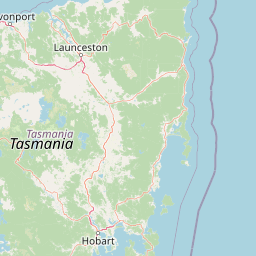
Map view of Mole Creek Karst National Park

Use this park location map to pinpoint Mole Creek Karst National Park in Australia, understand its exact geographic position, and read its mapped placement within the surrounding landscape more clearly.

Pigeon | © OpenStreetMap contributors

Location context for Mole Creek Karst National Park

Tasmania
Park atlas

Explore the surrounding Tasmanian protected landscapes and compare adjacent cave systems or wilderness areas.

Discover Other National Parks and Protected Areas Near Mole Creek Karst National Park
Explore nearby national parks and protected areas to understand the regional geographic context surrounding Mole Creek Karst National Park, including connected karst systems and adjacent wilderness. Directly compare conservation landscapes and gain deeper insight into Tasmania's unique protected-area spread.
National parkTasmania

Walls of Jerusalem National Park: A Mapped Alpine Wilderness in Tasmania

Explore protected landscapes with biblical place names.

Walls of Jerusalem National Park in Tasmania is a distinguished national park characterized by its rugged alpine terrain and dramatic quartzite formations, most notably King Davids Peak. The park's landscape is further distinguished by a unique series of features named after biblical locations, offering an evocative exploration for those interested in geographic discovery. As a protected wilderness area within the Tasmanian Wilderness World Heritage Area, it provides valuable insight into Australia's significant natural landscapes and their mapped representation.

Area
518 km²
Established
1978
IUCN
II
Relief
Mountain
National parkTasmania

Cradle Mountain, Lake St Clair National Park: Tasmania's Mapped Protected Landscape and Geography

Explore national park boundaries and regional natural terrain.

Gain insight into Cradle Mountain, Lake St Clair National Park, a protected national park in Tasmania, Australia. This entry provides a foundational understanding of its mapped terrain, geographic setting, and protected area status. Delve into the specific landscape characteristics that define this significant conservation zone and its place within the national atlas.

Area
1,614.43 km²
Established
1922
IUCN
II
Visitors
209K annual
National parkTasmania

Narawntapu National Park: Tasmania's Coastal Protected Landscape and Wildlife Atlas

Explore mapped boundaries, heathland, woodland, and intertidal bird habitats.

Narawntapu National Park showcases a remarkable protected coastal landscape on Tasmania's north coast, renowned for its exceptional density of marsupial wildlife and significant intertidal bird populations. Its diverse terrain, including heathland, woodland, and extensive mudflats, offers unique opportunities for geographic discovery and understanding the park's ecological importance. Examine its mapped natural features and protected status within the broader atlas of Australian reserves.

Area
43.49 km²
Established
1976
IUCN
II
Visitors
10.1K annual
National parkTasmania

Savage River National Park: Discover Tasmania's Protected Landscape Geography

Explore mapped boundaries and regional park context.

Savage River National Park represents a distinct protected area within Tasmania, Australia, offering valuable insights into the island's natural geography and conservation landscape. As a designated national park, its mapped territory contributes to the understanding of regional protected areas and their distribution across Tasmania. This entity serves as a crucial point for atlas-based exploration, allowing users to grasp its geographic identity and its place within a broader map of Australian natural territories.

Area
179.8 km²
Established
1999
IUCN
II
Climate
Temperate
National parkTasmania

Rocky Cape National Park: Tasmania's Coastal National Park with Ancient Aboriginal Heritage

Explore the dramatic headland, heath ecosystems, and mapped park boundaries.

Rocky Cape National Park on Tasmania's North West Coast is a nationally significant protected area recognized for its ancient Aboriginal archaeological heritage, representing at least 8,000 years of continuous occupation. The park's landscape unfolds across a dramatic coastal headland, featuring rugged rocky shores, expansive heathlands, and coastal woodlands that define this wild section of Tasmania. Its protected status underscores its importance for both cultural discovery and the preservation of unique Australian coastal ecosystems. Understanding Rocky Cape National Park offers direct insight into the region's geography and the enduring legacy of its first peoples.

Area
30.64 km²
Established
1967
IUCN
II
Relief
Lowland
National parkTasmania

Mount Field National Park: Explore Tasmania's Protected Landscape and Geographic Identity

Mapped terrain and regional atlas context for this Australian national park.

Mount Field National Park serves as a cornerstone of protected natural landscapes in Tasmania, Australia. This entry provides detailed geographic context, focusing on its mapped boundaries and distinct environmental setting. Users can explore its identity as a national park, understand its regional placement within Tasmania, and gain insight into the mapped terrain that defines this significant protected area. It is designed for atlas-based discovery of the park's landscape characteristics.

Area
162.65 km²
Established
1916
IUCN
II
Relief
Mountain
National parkTasmania

Southwest National Park: Tasmania's Core Wilderness National Park and World Heritage Landscape

Mapping the remote buttongrass moorlands and rugged terrain of this expansive park.

Southwest National Park represents a significant protected area in Tasmania, Australia, spanning over 6,183 square kilometers. As the heart of the Tasmanian Wilderness World Heritage Area, it showcases an extraordinary landscape characterized by vast buttongrass moorlands, ancient temperate rainforests, and dramatic mountainous terrain. This park is vital for its wilderness character and conservation significance, offering a unique opportunity to explore one of the Southern Hemisphere's last remaining untouched temperate wildernesses through its mapped geography and protected boundaries.

Area
6,182.67 km²
Established
1968
IUCN
II
Relief
Mountain
Watercolor illustration of a landscape featuring hills, trees, and a winding river
National parkTasmania

Douglas-Apsley National Park: Discover its Protected Landscape and Geographic Context in Tasmania

Mapped boundaries and regional terrain of a key Tasmanian national park.

Delve into the geographic details of Douglas-Apsley National Park, a designated national park situated in Tasmania, Australia. This entry provides insight into the park's protected landscape identity, its mapped boundaries, and its contribution to the rich regional geography of Tasmania. Understanding its place within the island's natural terrain is crucial for comprehensive atlas-driven exploration and appreciating Australia's protected areas.

Area
160.8 km²
Established
1989
IUCN
II
Relief
Upland

Common questions about visiting, size, designation, and location context for Mole Creek Karst National Park

Mole Creek Karst National Park FAQs for park facts, access, geography, and protected area context
Find quick answers about Mole Creek Karst National Park, including protected-area facts, park geography, trail and visitor context, and how the park fits into its surrounding country and regional landscape.
MoriAtlas Explorer

Continue Your Protected Areas Search Across the Global Atlas

Deepen your exploration by continuing the structured search for national parks and protected areas worldwide. Utilize the comprehensive filtering capabilities to compare different conservation landscapes and refine your understanding of global park geography. Discover more about the distribution and characteristics of protected natural areas.

Global natural geography