

Mori Atlas logo
National parkNeerabup National Park

Discover the mapped boundaries and regional context of Neerabup National Park.

Neerabup National Park: A Protected Landscape in Western Australia's Geography

Neerabup National Park stands as a key protected natural area within the diverse geography of Western Australia. As a designated national park, it offers a distinct geographic identity and a unique mapped landscape for exploration. Understanding its place within the broader regional context of Western Australia provides valuable insight for anyone interested in the atlas of protected lands and natural terrains across the continent.

Australian national parksIndigenous heritage sitesCoastal plain ecosystemsBirdwatching locationsWestern Australia nature reservesUrban-proximate parks

Neerabup National Park

National park

Park overview

Structured park overview, official facts, and landscape profile for Neerabup National Park

Neerabup National Park park facts, protected area profile, and essential visitor context
Review the core facts for Neerabup National Park, including designation, size, terrain, visitor scale, habitats, and operating context in one park-focused overview.

About Neerabup National Park

Neerabup National Park occupies a unique position in Western Australia's protected area network as a long, narrow corridor of remnant bushland threading through an area of rapidly expanding urban settlement. The park sits within the Northern Swan Coastal Plain, a biogeographic region characterized by sandy soils, wetlands, and woodlands that once covered extensive areas west of the Perth metropolitan region. Despite its modest size of 9.43 square kilometres, the park preserves an important example of the original coastal plain vegetation in an area that has been largely cleared for residential and agricultural use. The linear nature of the reserve reflects its origins along an ancient trackway that connected important wetland systems to the north, a route that remained in use through the colonial period as a stock route before being recognized for its Indigenous heritage significance. The absence of any formal visitor infrastructure distinguishes Neerabup from most national parks, offering an experience closer to walking through unmodified bushland than a conventional park visit.

Quick facts and research context for Neerabup National Park

Neerabup National Park covers 9.43 square kilometres along a thin 12-kilometre corridor west of Wanneroo Road in Perth's northern suburbs. The protected area was established in 1965 and is managed by the Western Australian Department of Environment and Conservation. It lies within the Northern Swan Coastal Plain Important Bird Area, recognized by BirdLife International for its role in supporting significant populations of Short-billed Black Cockatoos during the non-breeding season. The park contains no built infrastructure, no visitor facilities, and requires no entrance fee, making it one of the most undeveloped national parks near a major Australian city.

Park context

Deeper park guide and search-rich context for Neerabup National Park

Neerabup National Park history, landscape, wildlife, and travel context
Explore Neerabup National Park through its history, landscape character, ecosystems, wildlife, conservation priorities, cultural context, and seasonal travel timing in a structured park guide built for atlas discovery and search intent.

Why Neerabup National Park stands out

Neerabup National Park is best known for its role as a protected corridor along the Yaberoo Budjara Heritage Trail, an ancient Indigenous migration route linking Lake Joondalup with Loch McNess in neighbouring Yanchep National Park. The park is also recognized for its significance as a feeding ground for several thousand Short-billed Black Cockatoos during the non-breeding season, earning it inclusion in the Northern Swan Coastal Plain Important Bird Area. Its location on Perth's urban fringe, combined with a complete absence of visitor facilities, makes it distinctive among Australian national parks as a place where the natural landscape remains largely unmarked by development.

Neerabup National Park history and protected-area timeline

The park was established in 1965 as part of Western Australia's expanding national park system during the mid-twentieth century. The land it protects had long served as a thoroughfare, first for Indigenous groups moving between the lake systems of the coastal plain, and later for European settlers driving livestock along established stock routes. The Yaberoo Budjara Heritage Trail, which now traverses the park corridor, takes its name from the Yellalonga people whose traditional movements between Lake Joondalup and Loch McNess shaped the route's alignment. The trail was later used by colonial settlers as a stock route connecting pastoral areas to the north of Perth. Recognition of the route's Indigenous and historical significance led to its formal designation as a heritage trail, with the national park protecting the most natural and intact sections of the corridor. Management by the Department of Environment and Conservation has maintained the area's undeveloped character, with no visitor facilities added since the park's creation.

Neerabup National Park landscape and geographic character

The park occupies a long, thin corridor of bushland on the western side of Wanneroo Road, stretching approximately 12 kilometres through the City of Wanneroo. The landscape reflects the characteristic terrain of the Northern Swan Coastal Plain, with gentle undulating terrain and sandy soils supporting dense scrub and woodland. The vegetation consists primarily of Banksia woodland and scrubland, typical of the sandy soils of the Perth region. The corridor's narrow configuration means the park functions as a linear reserve, with its boundaries defined largely by the limits of remaining uncleared land. The landscape remains substantially unmodified by development within the park boundaries, though urban development presses against its edges on both sides of Wanneroo Road.

Neerabup National Park ecosystems, habitats, and plant life

The park protects a remnant example of the Northern Swan Coastal Plain ecosystem, a vegetation type that once covered extensive areas west of the Perth metropolitan region but has been largely cleared for urban development. The vegetation within the reserve includes Banksia woodlands, which provide important habitat for a range of native species. The coastal plain environment supports diverse plant communities adapted to the sandy, nutrient-poor soils and the Mediterranean climate of south-western Australia. The park's inclusion in the Northern Swan Coastal Plain Important Bird Area reflects its role in supporting significant bird populations, particularly the Short-billed Black Cockatoo, which uses the area as a feeding ground during the non-breeding season.

Neerabup National Park wildlife and species highlights

The park provides important habitat for several bird species, most notably the Short-billed Black Cockatoo, which congregates in significant numbers within the Northern Swan Coastal Plain Important Bird Area during the non-breeding season. The Banksia woodlands and scrubland support a range of bird species typical of the south-west Australian forest and woodland environments. The corridor nature of the reserve, connecting to other natural areas including Yanchep National Park to the north, allows for wildlife movement along the coastal plain. While detailed species inventories are not prominent in available sources, the intact vegetation and protected status suggest the area supports representative fauna of the coastal plain ecosystem.

Neerabup National Park conservation status and protection priorities

Neerabup National Park contributes to conservation of the Northern Swan Coastal Plain, one of the most heavily cleared and modified ecosystems in Western Australia. The park preserves remnant vegetation in an area experiencing rapid urban expansion, maintaining habitat connectivity along a corridor that links to other protected areas. Its designation as part of an Important Bird Area highlights the park's significance for species conservation, particularly for the Short-billed Black Cockatoo. The preservation of the Yaberoo Budjara Heritage Trail corridor also maintains cultural heritage values alongside ecological ones. As a relatively small reserve with no infrastructure, the park requires minimal management intervention, allowing natural processes to continue with minimal human disturbance.

Neerabup National Park cultural meaning and human context

The park is intrinsically linked to Indigenous heritage, protecting part of an ancient migration route used by the Yellalonga people to move between Lake Joondalup and Loch McNess. This route, now known as the Yaberoo Budjara Heritage Trail, represents one of the oldest continuous land use patterns in the Perth region. The trail takes its name from the traditional owners, with "Yaberoo" referring to a path or track and "Budjara" relating to the people of the area. After European colonization, the route served as a stock route for moving cattle and sheep between pastoral properties, representing a layer of colonial history overlaid on the Indigenous pathway. The heritage trail concept was developed to recognize and interpret both the Indigenous and settler history of the corridor.

Top sights and standout views in Neerabup National Park

The Yaberoo Budjara Heritage Trail traversing the park preserves an Indigenous migration route of significant cultural age, making it one of the more historically resonant natural areas near Perth. The park's significance as a Short-billed Black Cockatoo feeding ground during the non-breeding season has earned it recognition within the Northern Swan Coastal Plain Important Bird Area. Its complete lack of visitor facilities, roads, or entrance requirements offers an unusual, minimal-impact experience of unmodified coastal plain bushland within reach of a major city. The 12-kilometre linear corridor provides a distinctively different park experience from the typical destination-oriented national park.

Best time to visit Neerabup National Park

The park can be visited year-round given its proximity to Perth and lack of seasonal access restrictions. The best viewing opportunities for birdlife, particularly the Short-billed Black Cockatoos that congregate in the area during the non-breeding season, occur in the Australian autumn and winter months from March to August. The Mediterranean climate of the Perth region means summer months can be hot and dry, while winter brings mild temperatures and occasional rainfall that supports the park's vegetation. The undeveloped nature of the park means visitors should be prepared for walking without facilities, carrying adequate water and sun protection regardless of season.
Park location guide

Geography guide, regional context, and park location map for Neerabup National Park

Neerabup National Park park geography, regions, and map view in Australia
Understand where Neerabup National Park sits in Australia through a broader geographic reading of the surrounding landscape, nearby location context, and its mapped position within the national park landscape.

How Neerabup National Park fits into Australia

Australia is a constitutional monarchy and federal parliamentary democracy comprising six states and ten territories. With a population of nearly 28 million, it is one of the world's most urbanised countries, with most people concentrated on the eastern seaboard. The country has a high Human Development Index and is known for its cultural diversity, ancient Aboriginal heritage, and unique wildlife.

Wider geography shaping Neerabup National Park in Australia

Australia occupies the entire Australian continent, the island of Tasmania, and numerous smaller islands. It is the world's flattest and driest inhabited continent, featuring vast deserts in the interior (the Outback), tropical rainforests along the eastern coast, and a coastline bordering the Indian and Pacific Oceans.

Map view of Neerabup National Park

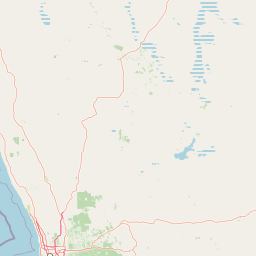
Use this park location map to pinpoint Neerabup National Park in Australia, understand its exact geographic position, and read its mapped placement within the surrounding landscape more clearly.

Pigeon | © OpenStreetMap contributors

Location context for Neerabup National Park

City of WannerooWestern Australia
Park atlas

Browse a wider atlas of nearby protected landscapes and natural reserves across the Northern Swan Coastal Plain.

Compare National Parks and Protected Areas Near Neerabup National Park, Western Australia
Continue your exploration from Neerabup National Park by browsing a curated list of other national parks and protected areas in the surrounding Western Australian region, including linear reserves and coastal plain ecosystems. Compare their unique geographic features, conservation values, and proximity to urban centers like Perth, offering a comprehensive regional overview of protected landscapes.
National parkWestern Australia

Yanchep National Park: Explore Its Unique Limestone Caves and Protected Bushland Geography

Discover the subterranean formations and coastal plain landscapes.

Yanchep National Park offers a singular opportunity for atlas-driven exploration of Western Australia's natural and cultural heritage. Situated on the Swan Coastal Plain, this national park is celebrated for its extensive network of limestone caves, including the notable Crystal Cave, providing a rare glimpse into subterranean geological processes. Beyond its underground wonders, the park encompasses diverse native bushland, supporting iconic koala colonies and offering insights into the region's ecological distinctiveness. Its deep Nyoongar heritage further enriches the understanding of this mapped protected landscape.

Area
28.76 km²
Established
1957
IUCN
II
Relief
Lowland
National parkWestern Australia

John Forrest National Park: National Park Atlas and Western Australia Protected Landscape

Mapped boundaries and regional geographic context.

Delve into the atlas-level details of John Forrest National Park, a protected area situated in Western Australia. This park's designation as a national park provides a focal point for understanding its specific geographic features and mapped extent. Users can explore its place within the broader regional geography of Western Australia, gaining structured insight into the protected landscape.

Area
26.78 km²
Established
1900
IUCN
II
Relief
Upland
National parkWestern Australia

Greenmount National Park: Western Australia National Park Landscape and Geography Atlas

Explore its protected boundaries and regional landscape context.

Greenmount National Park represents a distinct protected landscape within the diverse geography of Western Australia. As a National Park, its mapped boundaries are integral to understanding its regional context and offering users a point of detailed geographic discovery. This entry provides essential data on its protected status and geographic setting, supporting exploration of Australia's significant natural areas through an atlas-driven lens.

Area
2.02 km²
Established
1970
IUCN
II
Relief
Upland
National parkWestern Australia

Gooseberry Hill National Park: A Protected Landscape in Western Australia's Geography

Explore mapped boundaries and regional park context.

Gooseberry Hill National Park is a significant protected area designated as a national park within the diverse geography of Western Australia. This entry provides detailed insights into its specific location, mapped boundaries, and role as a conservation landscape. Understand how Gooseberry Hill National Park contributes to the broader atlas of protected lands in Western Australia, offering a foundational view for geographic exploration and landscape context.

Area
0.33 km²
Established
1970
IUCN
II
Relief
Highland
National parkWestern Australia

Avon Valley National Park: Protected National Park Discovery in Western Australia

Explore mapped boundaries and regional landscape context.

Delve into Avon Valley National Park, a designated national park offering rich opportunities for protected-area and landscape discovery. This page serves as an atlas-style entry point, detailing the park's mapped geography and its role within the diverse natural terrain of Western Australia. Understand its specific protected landscape identity and how it contributes to the broader conservation map.

Area
43.66 km²
Established
1970
IUCN
II
Relief
Mixed relief
Watercolor illustration of a landscape with rolling hills, trees, and fields
National parkWestern Australia

Kalamunda National Park: Explore Darling Scarp Woodland & Western Australia's Natural Terrain

A protected national park with distinct mapped landscape features.

Kalamunda National Park is an essential protected area located on the western slopes of the Darling Scarp, offering a clear representation of southwestern Australia's characteristic eucalypt woodland ecosystems. Its geography is defined by the escarpment's terrain, supporting tall marri, jarrah, and wandoo forests with a diverse understorey. As a national park, it provides critical habitat and contributes to the regional landscape context within Western Australia, making it a valuable point for atlas-driven discovery of protected natural areas.

Area
3.75 km²
Established
1964
IUCN
II
Relief
Mixed relief
National parkWestern Australia

Beelu National Park: Exploring Western Australia's Protected Jarrah-Marri Forest Landscape

Mapped Geographic Context & Natural Terrain Discovery

Beelu National Park, situated in Western Australia's Darling Range, offers an immersive experience within old-growth jarrah-marri forests. This protected area provides a vital glimpse into the region's natural landscapes, characterized by rolling hills and the Helena River valley. Users can explore the park's geographic setting, its mapped boundaries, and the unique ecological context it preserves. It stands as a significant natural reserve contributing to the understanding of Western Australia's conservation efforts and diverse terrain.

Area
46.17 km²
Established
1995
IUCN
II
Relief
Highland
National parkWestern Australia

Korung National Park: Protected Landscape and Map Context in Western Australia

Discover its unique dual bioregion geography.

Korung National Park is a protected national park in Western Australia, noted for its position along the Darling Scarp overlooking the Swan Coastal Plain. This reserve provides accessible natural experiences and showcases the ecological transition between two major southwest Australian bioregions. Its mapped landscapes offer a clear example of regional protected area planning and its importance for biodiversity conservation in the Perth metropolitan area.

Area
63.54 km²
Established
2004
IUCN
II
Relief
Mixed relief

Common questions about visiting, size, designation, and location context for Neerabup National Park

Neerabup National Park FAQs for park facts, access, geography, and protected area context
Find quick answers about Neerabup National Park, including protected-area facts, park geography, trail and visitor context, and how the park fits into its surrounding country and regional landscape.
MoriAtlas Explorer

Continue Your Protected Areas Search Across the Global Atlas

Deepen your exploration by continuing the structured search for national parks and protected areas worldwide. Utilize the comprehensive filtering capabilities to compare different conservation landscapes and refine your understanding of global park geography. Discover more about the distribution and characteristics of protected natural areas.

Global natural geography