Mori Atlas logo
National parkNew Forest National Park

Discover the mapped boundaries and unique geographic context of this historic protected area.

New Forest National Park: England's Ancient Woodland and Heathland Protected Landscape

Delve into the New Forest National Park, a profoundly distinctive protected landscape in southern England shaped by nearly a millennium of royal forest heritage and enduring common grazing rights. This area offers a rich tapestry of ancient woodlands, expansive heathlands, and valley mires, all mapped within England's broader geographic atlas. Explore the unique ecosystem and understand its place as one of the largest remaining tracts of unenclosed pasture and forest in lowland Britain, supporting significant biodiversity and living traditions.

HeathlandAncient woodlandNational ParkCommon landLowland habitatsRamsar site
Illustration showing a mountainous landscape with a waterfall, river, trees, and sky

New Forest National Park

National park

Park overview

Structured park overview, official facts, and landscape profile for New Forest National Park

New Forest National Park park facts, protected area profile, and essential visitor context
Review the core facts for New Forest National Park, including designation, size, terrain, visitor scale, habitats, and operating context in one park-focused overview.

About New Forest National Park

The New Forest stands as a living testament to nearly a thousand years of continuous stewardship and habitation in southern England. What makes this landscape particularly remarkable is that it is not a pristine wilderness preserved by exclusion but rather a working pastoral environment where ancient rights of common pasture are still actively exercised. The New Forest Commoners turn out their ponies, cattle, and pigs to graze the open heaths and woodland, maintaining the open character of the landscape that defines its ecological character. This partnership between human activity and natural processes has created a habitat of extraordinary biodiversity value, where heathland, woodland, valley bogs, and wood-pasture exist in a dynamic equilibrium. The forest drains to the south via three rivers—the Lymington, Beaulieu, and Avon Water—while the western areas are fed by streams including Latchmore Brook and Dockens Water. The area encompasses approximately 380 square kilometres of the historic royal forest within a national park of 566 square kilometres, and roughly 90 percent of the New Forest remains in Crown ownership, managed by Forestry England.

Quick facts and research context for New Forest National Park

The New Forest National Park covers 566 square kilometres and was established as a national park on 1 March 2005, making it one of the newer national parks in England. The area contains approximately 146 square kilometres of broadleaved woodland, 118 square kilometres of heathland and grassland, and 33 square kilometres of wet heathland. The New Forest has been designated as a Site of Special Scientific Interest, a Special Area of Conservation, a Special Protection Area, and a Ramsar wetland site, reflecting its international importance for biodiversity. The highest point is Pipers Wait at 129 metres above sea level near Nomansland.

Park context

Deeper park guide and search-rich context for New Forest National Park

New Forest National Park history, landscape, wildlife, and travel context
Explore New Forest National Park through its history, landscape character, ecosystems, wildlife, conservation priorities, cultural context, and seasonal travel timing in a structured park guide built for atlas discovery and search intent.

Why New Forest National Park stands out

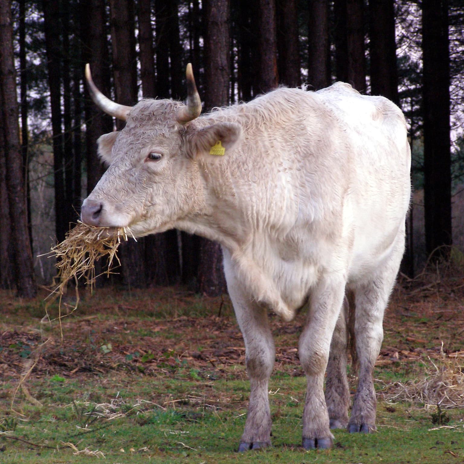
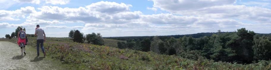
The New Forest is best known for its unique combination of royal heritage dating back nearly a millennium and its living agricultural traditions that continue through the ancient system of common rights. The area is famous for its iconic New Forest ponies, which are one of the indigenous horse breeds of the British Isles and roam freely across the heaths and woodlands. The forest is also renowned for its extensive lowland heathland, which represents one of the rarest habitats in Europe, and for the remarkable variety of wildlife it supports, including all three native British snake species, rare heathland birds such as the Dartford warbler, and the southern damselfly. The landscape is distinguished by its openness, created and maintained by centuries of grazing by commoners' ponies, cattle, and pigs.

Tall evergreen trees in a forest clearing with a group of people gathered on a bench
Group of people picnicking in a forest clearing at New Forest National Park

New Forest National Park history and protected-area timeline

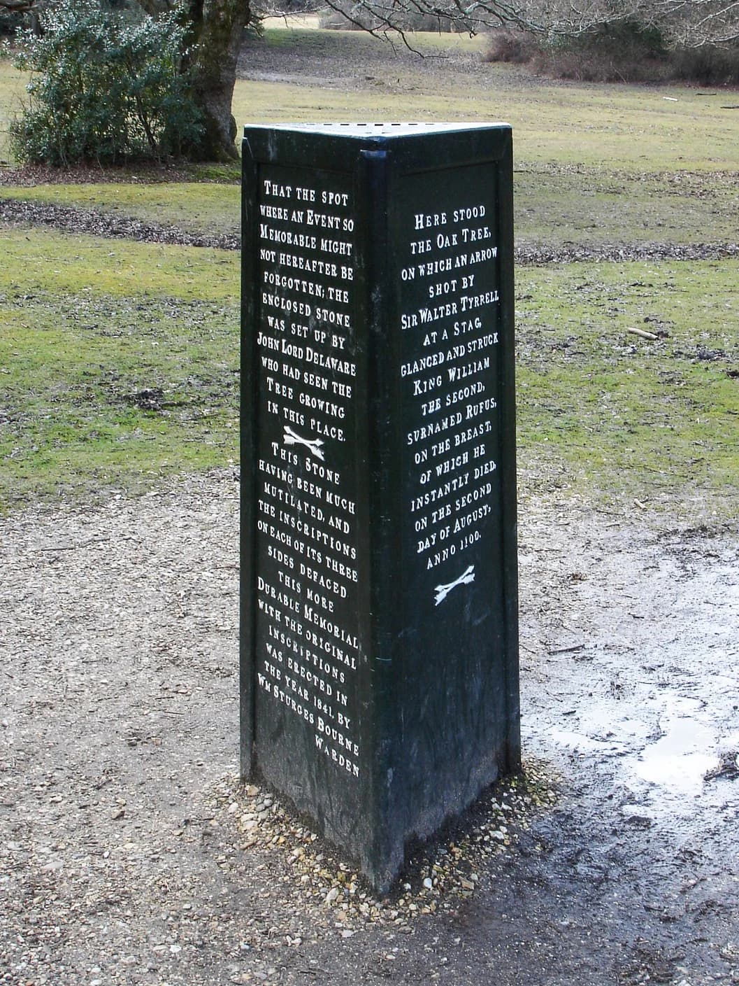
The New Forest's history as a royal forest begins with William the Conqueror, who declared it a royal hunting ground around 1079, creating it at the expense of more than 20 small hamlets and isolated farmsteads. The forest was first recorded as Nova Foresta in the Domesday Book of 1086, the only forest described in detail in that document. Medieval chroniclers alleged that William had evicted the inhabitants of 36 parishes to create the forest, though modern historians question this account given the poor quality of the soil in much of the area. Two of William's sons died in the forest: Prince Richard between 1069 and 1075, and King William II (William Rufus) in 1100, struck down while hunting. The reputed spot of Rufus's death is marked by the Rufus Stone. Common rights were confirmed by the New Forest Act 1697, and the forest became a source of timber for the Royal Navy in the 18th century. The New Forest Act 1877 confirmed the historic rights of the Commoners and limited enclosures to no more than 65 square kilometres. The forest gained SSSI status in 1971 and Heritage Area status in 1985, before becoming a National Park in 2005.

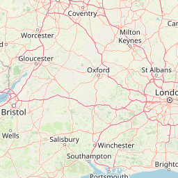
New Forest National Park landscape and geographic character

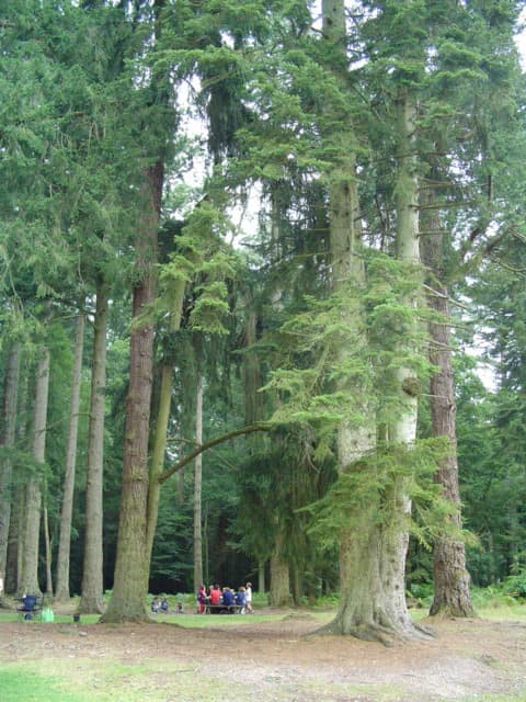
The New Forest landscape is characterized by a distinctive combination of heathland, woodland, and open pasture that is unique in lowland Britain. The heathland ranges from dry heaths dominated by heather and gorse to wet heaths with valley bogs supporting specialized plant communities. Ancient beech woodlands such as Mark Ash Wood and Mallard Wood represent some of the oldest wood-pasture in the country, while the enclosure plantations established since the 18th century add further ecological and visual variety. The highest point, Pipers Wait, rises to 129 metres near Nomansland, though the overall terrain is gently undulating. The geology consists mainly of sedimentary rock within the Hampshire Basin, creating the acid soils that have historically limited agriculture and encouraged the development of heathland. Three rivers—the Lymington, Beaulieu, and Avon Water—drain the forest to the south, while numerous streams flow west toward the Avon valley.

Beech trees in a forest with dappled sunlight and fallen leaves on the ground
Beech trees in Mallard Wood, New Forest National Park

New Forest National Park ecosystems, habitats, and plant life

The ecological importance of the New Forest derives from the extensive areas of lowland habitats that have survived here when they have been lost almost everywhere else in Britain. The forest contains several categories of internationally significant habitat, including valley bogs, alder carr, wet heaths, dry heaths, and deciduous woodland. These habitats support a remarkable concentration of rare species, including the New Forest cicada, the only cicada native to Great Britain, and plant species such as marsh gentian and marsh clubmoss. The wet heaths are particularly important for rare insects including the southern damselfly, large marsh grasshopper, and mole cricket. The forest also supports important populations of fungi, and the combination of habitats creates one of the most biodiverse landscapes in lowland Europe.

Light-colored cow with horns eating straw in a grassy field with trees in the background
Cow grazing on straw in a forested area of New Forest National Park

New Forest National Park wildlife and species highlights

The New Forest supports an exceptional variety of wildlife, with particular importance attached to specialist heathland birds that have declined dramatically across much of Britain. The Dartford warbler, woodlark, northern lapwing, Eurasian curlew, European nightjar, and Eurasian hobby all breed in significant numbers. The forest is one of the few remaining strongholds for the smooth snake, and all three native British snake species—the adder, barred grass snake, and smooth snake—are present. Deer are numerous, with fallow deer being most common, followed by roe deer and red deer, plus smaller populations of introduced sika deer and muntjac. The famous New Forest ponies are a familiar sight, along with commoners' cattle and the pigs released during the traditional pannage season. The New Forest Reptile Centre, established in 1969, plays an important role in conservation, particularly for sand lizards and great crested newts.

Two hikers walking on a path through heathland with forest in the background under a partly cloudy sky
Panorama showing the path and view across Acres Down in New Forest National Park

New Forest National Park conservation status and protection priorities

The New Forest's conservation significance is recognized through multiple layers of national and international protection. It is designated as a Site of Special Scientific Interest covering almost 300 square kilometres, making it the largest contiguous area of unsown vegetation in lowland Britain. As a Special Area of Conservation, Special Protection Area, and Ramsar wetland site, it receives EU-level protection for its habitats and species. The forest has its own Biodiversity Action Plan, and conservation measures include programs to reintroduce native species such as the sand lizard, which began in 1989, and ongoing efforts to restore conifer plantations to heathland and broadleaved woodland. The management of the forest balances multiple objectives, including the continuation of traditional commoning practices that are essential for maintaining the open heathland habitats.

New Forest National Park cultural meaning and human context

The New Forest's cultural identity is inseparable from the ancient system of common rights that has shaped the landscape for centuries. The New Forest Commoners exercise rights of common pasture that include turning out ponies, cattle, and pigs to graze, gathering fuel wood, cutting peat for fuel, and releasing pigs during the autumn pannage season to eat fallen acorns and beechnuts. These rights are enforced by official verderers and agisters, and the Court of Verderers represents the commoners rather than the Crown. This living tradition has created and maintained the open character of the forest, making it a rare example of a working historic landscape. The forest also contains around 250 round barrows and about 150 scheduled monuments, indicating its importance as a prehistoric landscape.

Two brown ponies walking on a street next to a shop with people nearby.
New Forest ponies walking on a street in Lyndhurst, Hampshire.

Top sights and standout views in New Forest National Park

The New Forest offers a distinctive combination of historical depth, ecological significance, and living traditions that sets it apart from other British landscapes. The ancient beech woodlands in Mallard Wood and Mark Ash Wood provide hauntingly beautiful environments, while the open heaths support populations of rare birds and reptiles. The opportunity to see New Forest ponies wandering freely through villages and across the heaths is a unique feature of any visit. The Rufus Stone marks the legendary site of King William II's death, connecting the landscape to nearly a thousand years of royal history. The Reptile Centre near Lyndhurst provides excellent opportunities to learn about the forest's remarkable reptile populations, and the network of footpaths and cycle routes offers waymarked exploration of the diverse habitats.

Dark stone monument with engraved historical text, situated in a grassy field with trees in the background
Rufus Stone historical monument with engraved text in New Forest National Park

Best time to visit New Forest National Park

The New Forest can be enjoyed throughout the year, with each season offering different qualities. Spring brings the emergence of reptile activity and the birth of pony foals, while summer sees the heather in full bloom across the heaths and the emergence of dragonflies and damselflies around the bogs. Autumn is the traditional pannage season when pigs are released to forage for acorns, and the woodland floors become carpeted with fallen leaves. Winter offers the best opportunities for deer viewing, as the animals become more visible in the reduced vegetation, and the stark beauty of the bare woodland creates a different atmosphere. The forest is busiest during summer weekends and the annual New Forest Show, but its extensive size means that quieter areas can always be found.

Park location guide

Geography guide, regional context, and park location map for New Forest National Park

New Forest National Park park geography, regions, and map view in United Kingdom
Understand where New Forest National Park sits in United Kingdom through a broader geographic reading of the surrounding landscape, nearby location context, and its mapped position within the national park landscape.

How New Forest National Park fits into United Kingdom

The United Kingdom is a parliamentary constitutional monarchy located in northwestern Europe, consisting of four constituent countries: England, Scotland, Wales, and Northern Ireland. As a major global power with over 69 million residents, it maintains significant international influence in politics, economics, and culture.

Wider geography shaping New Forest National Park in United Kingdom

The United Kingdom is an island nation located in northwestern Europe, surrounded by the Atlantic Ocean, North Sea, English Channel, Celtic Sea, and Irish Sea. It shares a land border with the Republic of Ireland to the west. The territory includes the island of Great Britain, the northeastern portion of Ireland, and most of the smaller British Isles islands.

Map view of New Forest National Park

Use this park location map to pinpoint New Forest National Park in United Kingdom, understand its exact geographic position, and read its mapped placement within the surrounding landscape more clearly.

Pigeon | © OpenStreetMap contributors

Location context for New Forest National Park

EnglandHampshireWiltshire

Gain visual insights into the park's lowland heathland, ancient woodlands, and unique pastoral landscapes.

New Forest National Park Imagery: Explore Ancient Woodlands, Heathland, and Iconic Ponies
Explore curated imagery capturing the distinct landscapes and diverse habitats within New Forest National Park. These photographs offer a visual understanding of its ancient woodlands, expansive heathland, and the iconic free-roaming ponies that shape its protected environment, aiding deep park discovery.

Tall evergreen trees in a forest clearing with a group of people gathered on a bench

Calm river reflecting alder trees and greenery, with lush vegetation along the banks

Beech trees in a forest with dappled sunlight and fallen leaves on the ground

Light-colored cow with horns eating straw in a grassy field with trees in the background

Two hikers walking on a path through heathland with forest in the background under a partly cloudy sky

Two Shetland Ponies, one light-colored and one brown, grazing in a grassy field

Two brown ponies walking on a street next to a shop with people nearby.

Dark stone monument with engraved historical text, situated in a grassy field with trees in the background

Gravel trail surrounded by dense forest with a cyclist riding away in the distance

Sunset over a pond with ice patches on the shoreline, surrounded by grass and trees

People walking on a dirt path near concrete enclosures with wire mesh tops in a park setting with trees and a greenhouse structure

Park atlas

Trace the spread of national parks and protected areas across southern England, comparing distinct lowland habitats and ancient woodlands.

Discover More Protected Areas Near New Forest National Park: Explore Adjacent Landscapes and Regional Park Geography
Explore national parks and protected areas geographically connected to New Forest National Park, including nearby ancient woodlands, heathlands, and other significant conservation landscapes. Broaden your understanding of regional protected-area patterns and compare the unique characteristics of each park's terrain and ecological features.
Watercolor illustration of a coastal landscape featuring green hills, white cliffs, and a body of water
National parkSouth East England

South Downs National Park: A Distinctive Chalk Landscape in South East England's Atlas

Iconic chalk downland, coastal cliffs, and mapped terrain.

South Downs National Park is a premier protected landscape in South East England, celebrated for its unique chalk downland terrain and dramatic coastal formations. This page provides detailed geographic context for the park, highlighting its rolling hills, dry valleys, and ancient woodlands. Discover the park's mapped boundaries and its significance within England's protected areas, offering a structured atlas view for landscape exploration.

Area
1,627 km²
Established
2010
IUCN
V
Visitors
18M annual
National parkWales

Brecon Beacons National Park: Explore Wales' Iconic Protected Mountain Landscape

Discover mapped terrain, park boundaries, and regional geography.

Brecon Beacons National Park, officially Bannau Brycheiniog, stands as a premier protected area within Wales, covering over 1,344 square kilometers of striking mountainous terrain. This national park is defined by its dramatic Old Red Sandstone ranges, including Pen y Fan, South Wales' highest peak, and features diverse landscapes from heather moorland to extensive river valleys. Its mapped boundaries encompass unique geological features, significant historical sites, and provide context for regional geographic exploration, making it a key destination for understanding protected lands in the UK.

Area
1,344 km²
Established
1957
IUCN
V
Visitors
4.4M annual
Watercolor illustration of Dartmoor moorland landscape with rolling hills, grassy vegetation, a stream, and distant mountains.
National parkDevon

Dartmoor National Park: Granite Tors and Prehistoric Landscape in Devon

Mapped protected area with significant Bronze Age remains.

Dartmoor National Park represents a distinctive granite upland in Devon, England, characterized by its dramatic tors and expansive moorland. This protected landscape is globally significant for its dense concentration of prehistoric archaeological sites, including stone circles, standing stones, and ancient settlements. Exploring Dartmoor offers a unique insight into Britain's regional geography, mapped terrain, and enduring connection to ancient human history.

Area
954 km²
Established
1951
IUCN
V
Visitors
11M annual
National parkPembrokeshire

Pembrokeshire Coast National Park: Mapped Coastal Boundaries and Protected Landscape Atlas

Explore unique seaside terrain and regional geography.

Delve into the Pembrokeshire Coast National Park, a premier protected landscape recognized for its extraordinary coastal formations and diverse natural terrain. This atlas entry details the park's distinct mapped boundaries, from its iconic limestone cliffs and sea stacks to its sheltered estuaries and inland Preseli Hills. Understand how this significant national park contributes to the protected area map of Pembrokeshire and offers unparalleled opportunities for geographic discovery along the Welsh coast.

Area
629 km²
Established
1952
IUCN
V
Relief
Mixed relief
National parkWales

Snowdonia National Park: Protected Landscape and Map Exploration in North Wales

Mountain terrain, glacial lakes, and regional geography.

Snowdonia National Park offers a profound exploration of mountainous protected landscapes in North Wales. This page details the park's mapped boundaries, revealing a terrain shaped by glaciation, featuring dramatic peaks like Snowdon, steep valleys, and pristine glacial lakes. Understand its geographic identity within the United Kingdom and how its protected status contributes to the regional landscape context, providing a unique focus for atlas-based discovery.

Area
2,142 km²
Established
1951
Relief
Mountain
Climate
Temperate
National parkUnited Kingdom

Peak District National Park: Explore Protected Landscape and Regional Geography

Mapped boundaries and natural terrain context for this UK national park.

Investigate the Peak District National Park, a cornerstone of the United Kingdom's protected natural areas. This MoriAtlas entry provides essential details on its geographic scope, mapped boundaries, and landscape characteristics. Engage with structured data to understand how this national park fits into the atlas of the United Kingdom, supporting detailed geographic and protected-area discovery for researchers and explorers.

Area
1,440 km²
Established
1951
IUCN
V
National park

The Broads National Park: Wetland Landscape, Rivers, and Regional Geography Atlas

Explore mapped waterways and protected reedbed ecosystems.

The Broads National Park offers a singular protected wetland landscape with over 200 kilometers of navigable waterways across its numerous shallow lakes, or 'broads.' Shaped by medieval peat excavations and natural processes, this area presents a unique geography of reedbeds and grazing marshes, punctuated by historic windmills. Discover the mapped extent of this protected landscape, its river systems, and its vital role in regional geography through structured atlas data.

Area
303 km²
Established
1989
IUCN
V
Relief
Lowland
Nature reserveBelgium

Zwin Nature Reserve: Belgium's Coastal Wetland and Historic Tidal Inlet Landscape

Mapped protected area boundaries and coastal wetland geography.

Delve into the Zwin Nature Reserve, a significant protected landscape on Belgium's North Sea coast. This area preserves the unique geography of a historical tidal creek system, characterized by extensive salt marshes, mudflats, and specialized coastal vegetation. As a vital habitat for diverse bird species and a showcase of tidal dynamics, Zwin offers a compelling case study in coastal conservation and landscape evolution, providing rich context for geographic and atlas-based exploration.

Area
1.58 km²
Established
1952
Relief
Lowland
Climate
Temperate

Common questions about visiting, size, designation, and location context for New Forest National Park

New Forest National Park FAQs for park facts, access, geography, and protected area context
Find quick answers about New Forest National Park, including protected-area facts, park geography, trail and visitor context, and how the park fits into its surrounding country and regional landscape.
MoriAtlas Explorer

Continue Your Protected Areas Search Across the Global Atlas

Deepen your exploration by continuing the structured search for national parks and protected areas worldwide. Utilize the comprehensive filtering capabilities to compare different conservation landscapes and refine your understanding of global park geography. Discover more about the distribution and characteristics of protected natural areas.

Global natural geography