

Mori Atlas logo
National parkOued Zeen National Park

Discover the protected area boundaries and regional geography of Oued Zeen National Park in Tunisia.

Oued Zeen National Park: Tunisia National Park, Mapped Landscape and Geographic Atlas Entry

Oued Zeen National Park represents a significant protected landscape within Tunisia, offering a distinct entry in the nation's geographic atlas. This national park designation highlights its importance for understanding regional conservation and natural terrain. Explore its mapped boundaries and surrounding geography to gain structured insights into Tunisia's protected areas and landscape context.

Mediterranean forestCork oakMountain landscapeNorth AfricaProtected areaTell Atlas

Oued Zeen National Park

National park

Park overview

Structured park overview, official facts, and landscape profile for Oued Zeen National Park

Oued Zeen National Park park facts, protected area profile, and essential visitor context

Review the core facts for Oued Zeen National Park, including designation, size, terrain, visitor scale, habitats, and operating context in one park-focused overview.

About Oued Zeen National Park

Oued Zeen National Park occupies a significant position within Tunisia's protected area network as a representative of Mediterranean forest ecosystems in the country's northwestern highlands. The park's location in the Aïn Draham delegation places it within the Tell Atlas mountain range, where elevation and orographic rainfall create conditions suitable for tree growth that are otherwise rare in Tunisia. The cork oak forests that dominate the park's vegetation are a characteristic feature of Mediterranean woodlands across the region, and their presence here reflects the ecological continuity between Tunisia and the broader Mediterranean basin. The park was established in 2010 as part of Tunisia's ongoing efforts to develop a comprehensive national park system that represents the country's diverse ecological regions, from coastal wetlands to mountain forests. The protection of this Mediterranean forest landscape acknowledges both the ecological value of these ecosystems and their importance for biodiversity conservation in a country where desert and semi-arid environments predominate.

Quick facts and research context for Oued Zeen National Park

Oued Zeen National Park is located in the Jendouba Governorate of northwestern Tunisia, in the delegation of Aïn Draham. The park spans roughly 6,700 hectares of mountainous Mediterranean terrain at the southern edge of the Tell Atlas mountain system. It was officially designated as a national park in 2010, making it one of Tunisia's more recently established protected areas. The region is characterized by cork oak forests, maquis shrubland, and rugged topography that contrasts sharply with the surrounding semi-arid lowlands.

Protection and recognition

Verifying the geographic conservation scope and official terrestrial protection framework.

Documenting the Protection Status and Terrestrial Boundaries of Oued Zeen National Park

Standardized data details the terrestrial protection status and conservation framework established for Oued Zeen National Park. Geographic researchers can trace official boundaries and verify designation records to understand how the geographic area fits into regional conservation networks.

Protection details

Protection scope
Terrestrial
Park context

Deeper park guide and search-rich context for Oued Zeen National Park

Oued Zeen National Park history, landscape, wildlife, and travel context

Explore Oued Zeen National Park through its history, landscape character, ecosystems, wildlife, conservation priorities, cultural context, and seasonal travel timing in a structured park guide built for atlas discovery and search intent.

Why Oued Zeen National Park stands out

Oued Zeen National Park is best known for its cork oak forests, which represent one of the most distinctive Mediterranean woodland types in North Africa. The park protects a mountainous landscape in Tunisia's northwest that supports relatively lush vegetation compared to the country's generally arid climate, owing to higher elevation and increased precipitation. These cork oak formations provide habitat for a variety of species and represent a conservation priority for maintaining Tunisia's Mediterranean forest estate.

Oued Zeen National Park history and protected-area timeline

Oued Zeen National Park was established in 2010, representing a relatively recent addition to Tunisia's network of protected areas. The park's creation reflected a growing recognition of the ecological significance of Tunisia's Mediterranean forest regions, particularly the cork oak woodlands of the northwest. Prior to national park designation, the area likely existed in some form of regional protection, though specific earlier conservation status is not detailed in available sources. The establishment of the park coincided with broader governmental efforts in Tunisia during the 2000s to expand and strengthen the national protected areas network, focusing on representing all major ecological zones within the country. The selection of Oued Zeen for national park status acknowledged both the quality of its forest ecosystems and the need to provide formal protection to habitats that face pressures from human activities including logging, grazing, and agricultural expansion.

Oued Zeen National Park landscape and geographic character

The landscape of Oued Zeen National Park is characterized by mountainous terrain typical of the Tell Atlas region in northwestern Tunisia. The topography features rugged hills and ridgelines with varying slopes and aspects, creating a diverse physical environment that influences local climate and vegetation patterns. The elevation of the park provides a cooler and wetter climate than the surrounding lowlands, supporting the development of forest cover where semi-arid conditions prevail below. The vegetation is dominated by cork oak, a Mediterranean tree species that thrives in areas with sufficient moisture, forming open woodland with an understory of maquis shrubs including species of laurel, cistus, and Erica. The park's landscape includes rocky outcrops and exposed substrates typical of limestone formations in this region, with seasonal streams and drainage channels that carry water during the wetter months.

Oued Zeen National Park ecosystems, habitats, and plant life

The natural environment of Oued Zeen National Park centers on Mediterranean forest ecosystems that are ecologically significant within the North African context. The cork oak woodlands represent the dominant habitat type, forming a semi-open canopy that allows light to reach the forest floor and supports a diverse shrub layer. These forests are characteristic of the Mediterranean maquis biome, a fire-adapted ecosystem that has evolved with the region's climate of wet winters and dry summers. The park's relatively higher elevation and precipitation support plant communities that contrast sharply with the surrounding landscapes, where steppe and semi-desert vegetation predominate. The ecological importance of this protected area lies in its representation of a habitat type that has been reduced across its range by clearing for agriculture, logging, and overgrazing.

Oued Zeen National Park wildlife and species highlights

The wildlife of Oued Zeen National Park is typical of Mediterranean forest environments in North Africa, though detailed species documentation for the park specifically is limited. The cork oak forests and maquis shrubland provide habitat for a variety of bird species, including numerous songbirds that inhabit the woodland canopy and denser shrub areas. Mammals likely present in the park include wild boar, various rodent species, and possibly smaller carnivores such as foxes and genets that inhabit the forest and shrubland. The Mediterranean woodland environment supports invertebrate communities important for ecosystem functioning, including pollinators and decomposers. While specific endangered species documentation is limited, the protected status of the area provides conservation benefit for the broader fauna community of Tunisia's northwestern forests.

Oued Zeen National Park conservation status and protection priorities

Oued Zeen National Park represents an important conservation achievement for Tunisia, providing formal protection to Mediterranean forest ecosystems that have experienced significant historical loss across their range. The establishment of the park in 2010 created a protected area dedicated to preserving cork oak forests and the biodiversity they support in the Tell Atlas region. These forests face ongoing pressures from human activities, including timber extraction, charcoal production, grazing by domestic livestock, and conversion to agricultural land. The national park designation provides a framework for management that balances conservation objectives with sustainable use where appropriate. The park contributes to Tunisia's commitments to maintaining biodiversity and protecting representative examples of the country's major ecological zones.

Oued Zeen National Park cultural meaning and human context

Oued Zeen National Park exists within a cultural landscape shaped by centuries of human activity in northwestern Tunisia. The region around Aïn Draham has a history of agricultural and pastoral use, with communities that have interacted with the forest environment for resources including cork, firewood, and grazing. The Arabic name of the park, الحديقة الوطنية بوادي الزان, reflects the local linguistic context and the Arabic-language heritage of the region. The area is situated within a part of Tunisia that has maintained strong connections to traditional land-use practices, though modern conservation priorities have shifted toward forest protection. The establishment of the national park represents a contemporary approach to managing landscapes that have cultural significance while ensuring their ecological continuity for future generations.

Top sights and standout views in Oued Zeen National Park

Oued Zeen National Park protects one of Tunisia's most significant Mediterranean forest areas, with cork oak woodlands forming the ecological centerpiece of the protected landscape. The park offers a glimpse into the greener, more luxuriant side of Tunisia, where mountain elevation and adequate rainfall create conditions for forest development that travelers to this mostly arid country might not expect. The contrast between the park's wooded highlands and the surrounding semi-arid plains illustrates the ecological diversity that Tunisia's protected areas network aims to preserve.

Best time to visit Oued Zeen National Park

The best time to visit Oued Zeen National Park is during the spring months from March through May, when mild temperatures and blooming vegetation showcase the park's natural beauty at its most vibrant. Autumn from September to November also offers favorable conditions, with comfortable temperatures and the forest taking on autumn colors. Summer months can be warm but are generally manageable for exploration, while winter brings cooler temperatures and occasional precipitation that contributes to the forest's moisture balance.

Monthly climate preview

Analysis of long-term temperature ranges and monthly precipitation distribution across representative coordinates

Oued Zeen National Park Climate Normals and Measured Annual Weather Patterns

Representative coordinates record measured monthly temperature swings from 11.38 degrees Celsius to 26.54 degrees Celsius alongside shifting precipitation rates from 0.17 to 3.14 millimeters per day. Examining the full twelve-month dataset clarifies long-term meteorological normals and climate rhythms across Oued Zeen National Park.
Annual mean18 °C
11 °C27 °C
Jan12°
Feb11°
Mar13°
Apr15°
May19°
Jun23°
Jul26°
Aug27°
Sep24°
Oct20°
Nov16°
Dec13°
Warmest month
August

26.5 °C

Coolest month
February

11.4 °C

Wettest month
December

3.1 mm/day

Driest month
July

0.2 mm/day

Park location guide

Geography guide, regional context, and park location map for Oued Zeen National Park

Oued Zeen National Park park geography, regions, and map view in Tunisia

Understand where Oued Zeen National Park sits in Tunisia through a broader geographic reading of the surrounding landscape, nearby location context, and its mapped position within the national park landscape.

How Oued Zeen National Park fits into Tunisia

Tunisia is a Maghreb country in North Africa with a Mediterranean coastline, bordered by Algeria and Libya. The country features the ancient ruins of Carthage, the Great Mosque of Kairouan, and portions of the Atlas Mountains and Sahara Desert. With a population of approximately 12 million, Tunisia operates as a unitary presidential republic with Arabic as the official language.

Wider geography shaping Oued Zeen National Park in Tunisia

Tunisia occupies 163,610 km² in North Africa, bordering Algeria to the west and southwest, Libya to the southeast, and the Mediterranean Sea to the north and east. The country features the eastern end of the Atlas Mountains in the north and extends into the northern Sahara Desert in the south. Its 1,300 km of coastline runs along the Mediterranean Basin. Africa's northernmost point, Cape Angela, is located in Tunisia.

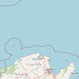
Map view of Oued Zeen National Park

Use this park location map to pinpoint Oued Zeen National Park in Tunisia, understand its exact geographic position, and read its mapped placement within the surrounding landscape more clearly.

Pigeon | © OpenStreetMap contributors

Location context for Oued Zeen National Park

Aïn Draham
Park atlas

Compare the diverse Mediterranean forest landscapes and mountainous terrain within Tunisia's Tell Atlas region.

Explore Related National Parks and Protected Areas Near Oued Zeen National Park

Browse a curated selection of national parks and protected areas, focusing on those situated geographically near Oued Zeen National Park in Tunisia's Tell Atlas region. Compare these regional protected landscapes to trace the spread of Mediterranean cork oak forests and understand the distinct ecological importance of Tunisia's diverse mountain environments.
National parkEl Tarf Province
About 20 km away#1 closest

West

El Kala National Park: Protected Wetlands and Barbary Stag Habitat

Explore its mapped geography and vital ecosystem context.

El Kala National Park represents a crucial protected landscape within El Tarf Province, Algeria, recognized internationally for its extensive Mediterranean wetlands and rich biodiversity. This national park is a vital ecological zone, comprising six major lakes and a significant stretch of coastline, offering a unique mosaic of aquatic and terrestrial environments. Its role as a sanctuary for the Barbary stag and migratory birds highlights its importance in regional conservation efforts. Exploring El Kala National Park provides insight into the mapped terrain, protected boundaries, and distinct geographic features that define this significant North African natural area.

Area
764 km²
Established
1993
IUCN
II
Visitors
30K annual
National parkJendouba Governorate
About 25 km away#2 closest

Southwest

El Feidja National Park: National Park Mapping and Protected Landscape Discovery

Explore geographic context within Jendouba Governorate.

Gain a clear understanding of El Feidja National Park's protected status and its geographic footprint. This page offers detailed insights into the park's mapped boundaries and landscape characteristics, situated within the Jendouba Governorate. It serves as a primary resource for atlas exploration, highlighting the natural terrain and regional significance of this Tunisian national park.

Area
27.65 km²
Established
1990
IUCN
II
Relief
Mountain
National parkBizerte Governorate
About 26 km away#3 closest

North

Jebel Chitana-Cap Négro National Park: National Park Protected Area & Landscape Identity

Explore the mapped geography of Jebel Chitana-Cap Négro National Park.

As a designated national park, Jebel Chitana-Cap Négro National Park represents a key protected area for understanding the regional geography of Bizerte Governorate. This entry provides structured information focused on the park's geographic scope, its mapped boundaries, and its significance as a protected landscape. It is designed for users seeking detailed, atlas-style context on Jebel Chitana-Cap Négro National Park's natural setting and its place within Tunisia's protected lands network.

Area
101.2 km²
Established
2010
Relief
Mountain
Scope
Terrestrial
National parkTunisia
About 66 km away#4 closest

Northeast

Ichkeul National Park: Tunisia's Key Protected Landscape for Geographic Discovery

Explore the mapped geography and regional context of this Tunisian national park.

Ichkeul National Park is a crucial protected area located in Tunisia, offering a distinct focal point for geographic exploration and atlas-based understanding. This park's mapped boundaries and protected status are central to appreciating its role within Tunisia's natural landscapes and the wider North African region. Through structured data and detailed geographic context, users can gain insight into Ichkeul National Park's unique environmental identity and its significance as a protected natural resource.

National parkTunisia
About 120 km away#5 closest

Southeast

Jebel Serj National Park: Central Tunisia's Distinctive Mountain Protected Area

Explore its terrain and protected landscape context.

Jebel Serj National Park, established in 2010, safeguards a significant mountainous territory in central Tunisia, distinguishing itself from the broader semi-arid plains. This protected landscape showcases the Djebel Serj massif, a unique topographical feature that serves as an ecological bridge between Tunisia's northern and southern regions. Users exploring this page can gain an atlas-level understanding of the park's mapped boundaries, its geological character, and its contribution to the conservation of representative natural diversity within North Africa's transitional ecosystems.

Area
17.2 km²
Established
2010
IUCN
II
Scope
Terrestrial
National parkTunisia
About 134 km away#6 closest

East

Boukornine National Park: A Protected Mediterranean Mountain Landscape in Tunisia

Explore its mapped terrain and unique protected ecosystem.

Boukornine National Park in Tunisia represents a significant protected landscape, notable for its central granite peak, Jebel Boukornine, which rises sharply above the surrounding coastal plains. This national park, covering approximately 1,939 hectares, preserves a distinctive Mediterranean mountain ecosystem. Its rugged terrain, rocky slopes, and the presence of Aïn Zargua spring support a unique concentration of species, including notable flora and fauna. Understanding Boukornine National Park provides insight into the regional geography and the importance of conserving these mountainous protected areas within Tunisia.

Area
19.39 km²
Established
1987
IUCN
II
Relief
Mountain
National parkTunisia
About 172 km away#7 closest

East

Zembra National Park: A Protected Island Landscape in Tunisia's Mediterranean Waters

Explore its unique geography and mapped protected area boundaries.

Zembra National Park safeguards a rugged, mountainous island environment characterized by dramatic limestone cliffs plunging into the Mediterranean Sea. This national park is renowned for its exceptional avian populations, including the endangered Eleonora's falcon, and its preserved Mediterranean maquis ecosystem, supporting endemic plant species. The park's geographic isolation contributes to its status as a significant biodiversity hotspot, offering a distinct lens for understanding island ecosystems and conservation efforts within the broader Tunisian geography.

IUCN
II
National parkKasserine Governorate
About 189 km away#8 closest

South

Chambi National Park: Mountain Geography and Protected Landscape Analysis

High elevation terrain in the Kasserine Governorate

Chambi National Park encompasses 67 square kilometers of rugged, high-altitude terrain in Tunisia. This resource maps the park's mountain ecosystem, from its forested valleys to its exposed rocky peaks, providing a structured overview of this significant protected landscape near the Algerian border.

Area
67.23 km²
Established
1980
IUCN
II
Relief
Mountain

Common questions about visiting, size, designation, and location context for Oued Zeen National Park

Oued Zeen National Park FAQs for park facts, access, geography, and protected area context

Find quick answers about Oued Zeen National Park, including protected-area facts, park geography, trail and visitor context, and how the park fits into its surrounding country and regional landscape.
MoriAtlas Explorer

Continue Your Protected Areas Search Across the Global Atlas

Deepen your exploration by continuing the structured search for national parks and protected areas worldwide. Utilize the comprehensive filtering capabilities to compare different conservation landscapes and refine your understanding of global park geography. Discover more about the distribution and characteristics of protected natural areas.

Global natural geography