

Mori Atlas logo
National parkPhu Kao–Phu Phan Kham National Park

Navigate the mapped natural terrain and protected boundaries of this Thai national park.

Phu Kao–Phu Phan Kham National Park: Protected Landscape Geography in Khon Kaen Province

Phu Kao–Phu Phan Kham National Park represents a significant protected landscape within Khon Kaen Province, situated in the Isan region of northeastern Thailand. This national park offers a focused point for understanding regional geography, allowing for detailed exploration of its protected area identity and mapped terrain. As part of Thailand's network of natural reserves, its boundaries and natural context are key elements for geographic discovery and atlas-based study of the Khorat Plateau's landscapes.

National parkKhorat PlateauRock art sitesMountain forestsDeciduous dipterocarpPrehistoric Thailand

Phu Kao–Phu Phan Kham National Park

National park

Park overview

Structured park overview, official facts, and landscape profile for Phu Kao, Phu Phan Kham National Park

Phu Kao, Phu Phan Kham National Park park facts, protected area profile, and essential visitor context
Review the core facts for Phu Kao, Phu Phan Kham National Park, including designation, size, terrain, visitor scale, habitats, and operating context in one park-focused overview.

About Phu Kao, Phu Phan Kham National Park

Phu Kao–Phu Phan Kham National Park represents a distinctive protected area in Thailand's northeastern highlands, where two separate mountain ranges are unified within a single park boundaries. The western section, centered around the Phu Kao range, comprises nine distinct peaks including Phu Fang, Phu Khum Pun, Phu Han, Phu Moey, Phu Khor Mor, Phu Chen, Phu Phrao, Phu Luak, and Phu Wat, collectively forming a complex geological structure with elevated plateaus surrounded by steeper slopes. This formation has led researchers to hypothesize that the area may represent the remnants of an extinct volcano or a geological uplift zone active hundreds of millions of years ago. The eastern section follows the Phu Phan Kham range, a longer mountain chain running along a northeast-southwest orientation within the greater Phu Phan Mountains system. When the Ubol Ratana Dam was constructed in the southwestern portion of this range, significant lowland areas were flooded, creating a reservoir that now forms part of the park's eastern section and provides habitat for aquatic and waterside species. The park headquarters sits on the shores of this reservoir, offering visitors access to both mountain and water-based recreation opportunities. The combination of ancient geological formations, significant archaeological sites, and varied landscape types creates a park that serves multiple purposes for both conservation and education.

Quick facts and research context for Phu Kao, Phu Phan Kham National Park

Phu Kao–Phu Phan Kham National Park occupies 318 square kilometers across Ubolratana and Phu Wiang districts in Khon Kaen Province and Non Sang district in Nong Bua Lamphu Province. The park is located approximately 60 kilometers northwest of Khon Kaen city. It was established in 1985 as Thailand's 50th national park and is managed by the Department of National Parks, Wildlife and Plant Conservation. The park is named after the two mountain ranges that dominate its terrain, both characterized by sandstone geology and complex ridgeline formations.

Park context

Deeper park guide and search-rich context for Phu Kao, Phu Phan Kham National Park

Phu Kao, Phu Phan Kham National Park history, landscape, wildlife, and travel context
Explore Phu Kao, Phu Phan Kham National Park through its history, landscape character, ecosystems, wildlife, conservation priorities, cultural context, and seasonal travel timing in a structured park guide built for atlas discovery and search intent.

Why Phu Kao, Phu Phan Kham National Park stands out

Phu Kao, Phu Phan Kham National Park is best known for its remarkable collection of prehistoric rock paintings found throughout numerous caves in the western section, including sites such as Tham Palan Hai, Tham Muem, and Tham Rakha Khanit. These ancient artworks, alongside Ban Chiang-era artifacts, date back more than 3,500 years, making the park significant for both archaeological study and cultural tourism. The park is also distinguished by its dual mountain range character, with the Phu Kao range featuring nine peaks with complex, crater-like formations suggesting ancient volcanic origins, while the eastern section encompasses parts of the Ubol Ratana Dam reservoir and dramatic wind-eroded rock formations at Ham Tang.

Phu Kao, Phu Phan Kham National Park history and protected-area timeline

The establishment of Phu Kao–Phu Phan Kham National Park in 1985 marked a significant milestone in Thailand's conservation history as the nation's 50th national park. Prior to formal protection, the area had long been recognized for its archaeological significance, with numerous caves throughout the western mountain section serving as repositories of prehistoric human activity. These caves contain rock paintings depicting human figures, animals, and geometric patterns created by ancient inhabitants more than 3,500 years ago. Archaeological excavations in the park area have also yielded artifacts associated with the Ban Chiang culture, one of Southeast Asia's most important prehistoric civilizations known for its sophisticated bronze-working traditions. The park's historical significance extends beyond its natural features, representing a continuous human presence in these highlands spanning millennia. The integration of these cultural resources with the mountainous landscape formed the basis for the park's establishment, recognizing that protection should encompass both natural ecosystems and the cultural heritage embedded within them.

Phu Kao, Phu Phan Kham National Park landscape and geographic character

The park's landscape is defined by its two distinct mountain ranges with contrasting geological character. The Phu Kao range in the western section presents a complex cluster of nine peaks rising from a central plateau area, creating a terrain of nested ridges and valleys that resembles an upturned basin or caldera. The outer peaks reach higher elevations with steeper slopes, while the inner foothills maintain more moderate gradients. This distinctive topography suggests either ancient volcanic activity or major crustal deformation that uplifted the entire region. The underlying geology consists primarily of sandstone layers overlying shale and mudstone bases, with laterite and sandy soils scattered throughout the higher elevations. The Phu Phan Kham range in the eastern section forms a more linear ridge system oriented along a northeast-southwest axis, with the Ubol Ratana reservoir occupying the lower southwestern basin where the original valley was flooded. Rock formations at Ham Tang have been shaped by wind and water erosion into unusual mushroom-like pillars and other distinctive shapes. The western section contains the Tat Fa and Tat Hin Taek waterfalls, where water cascades through forested areas before dropping into natural pools below.

Phu Kao, Phu Phan Kham National Park ecosystems, habitats, and plant life

The park supports three primary forest types reflecting the elevation gradients and moisture availability across its terrain. Deciduous dipterocarp forest dominates the higher elevations, with species such as Shorea roxburghii, Dipterocarpus obtusifolius, Olea brachiata, and various Cycas species forming the canopy. This forest type characterizes the majority of the park's area and provides the classic savanna-like appearance of northeastern Thailand's highlands during the dry season when trees shed their leaves. Mixed deciduous forest occupies lower elevations, particularly along watercourses and valley floors, where species like Burma padauk, wild almond, and Ceylon oak create more diverse forest structure. Dry evergreen forest is restricted to creek margins and areas with consistent moisture, featuring species including Lagerstroemia calyculata, Dipterocarpus alatus, and Afzelia xylocarpa. The forest composition reflects the park's position within the Khorat Plateau's ecological zone, where seasonal moisture patterns strongly influence vegetation communities. The reservoir and its associated wetlands add an aquatic dimension to the park's ecological diversity.

Phu Kao, Phu Phan Kham National Park wildlife and species highlights

Birdlife within the park reflects the diverse forest habitats present across its elevation range. Common species observed include the white wagtail and Richard's pipit in more open areas, while the sooty-headed bulbul and streak-eared bulbul inhabit forest edges and secondary growth. The oriental magpie-robin and common tailorbird are frequently found in the understory and thicker vegetation, while the greater coucal moves through denser cover. The millipede photographed within the park represents the diverse invertebrate community that contributes to forest ecosystem function. While the English Wikipedia source provides limited specific wildlife documentation, the varied forest types from dry evergreen along watercourses through deciduous dipterocarp on slopes to the reservoir environment suggest a corresponding diversity of fauna adapted to these different habitats. The presence of the reservoir also supports waterfowl and fish species that occupy niches distinct from the forest-dwelling fauna.

Phu Kao, Phu Phan Kham National Park conservation status and protection priorities

Phu Kao–Phu Phan Kham National Park contributes to Thailand's protected area network by preserving representative samples of the northeastern highland ecosystems that face pressures from agricultural expansion and development. The park's dual-range character protects forest types that are characteristic of the Khorat Plateau while also safeguarding significant archaeological sites that represent human cultural heritage spanning thousands of years. The management of the park requires balancing visitor access to attractions like the waterfalls and rock formations with the need to protect sensitive archaeological sites and maintain ecosystem integrity. As Thailand's 50th national park, it represents a maturing approach to protected area designation that increasingly recognized the importance of cultural landscape values alongside purely ecological considerations. The Ubol Ratana Dam reservoir within the park boundaries adds a further management dimension requiring coordination between conservation and water resource authorities.

Phu Kao, Phu Phan Kham National Park cultural meaning and human context

The cultural significance of Phu Kao–Phu Phan Kham extends to both prehistoric and historical periods. The rock paintings found in caves throughout the western section represent some of the oldest artistic expressions in mainland Southeast Asia, with archaeological evidence suggesting creation during the third millennium BCE or earlier. These paintings provide insights into the lives, beliefs, and artistic traditions of the region's early inhabitants. The discovery of Ban Chiang era artifacts further connects the park area to one of Thailand's most significant prehistoric cultures, known for early bronze metallurgy. The western section also contains Wat Phra Phutthabat Phu Kao, a temple that features rock footprints claimed to be those of a hunter and his dog, adding a layer of local religious and folk tradition to the landscape. These cultural elements are woven into the physical environment of mountains, caves, and forests, creating a cultural landscape where natural and historical values are inseparable.

Top sights and standout views in Phu Kao, Phu Phan Kham National Park

The park's most compelling attractions include the ancient rock art sites of Tham Palan Hai and other caves with prehistoric paintings, the nine-peak landscape of the Phu Kao range with its geological complexity, the reservoir vistas at Ubol Ratana Dam, and the sculpted rock formations at Ham Tang. The Tat Fa and Tat Hin Taek waterfalls provide scenic water features in the western section, while the cultural site at Wat Phra Phutthabat Phu Kao adds a religious dimension to the park experience. The park's dual personality, combining highland mountain terrain with significant reservoir waters, offers visitors diverse recreational opportunities within a single protected area.

Best time to visit Phu Kao, Phu Phan Kham National Park

The optimal time to visit Phu Kao–Phu Phan Kham National Park falls during the cool dry season from November through February, when average temperatures are most comfortable for hiking and outdoor activities. The Thai Wikipedia source describes three distinct seasons: a hot season from March to May with peak heat in April, a rainy season from June to October with heaviest rainfall in September, and a cool season from November to February influenced by high-pressure systems from southern China with lowest temperatures in January. The cool season offers the most stable conditions for exploring the park's trails, viewing waterfalls which will still have water flow from the preceding rainy season, and appreciating the forest scenery. Visitors during the hot season should anticipate high temperatures, particularly in April, while the rainy season brings potential access limitations and increased humidity though vegetation is at its lushest.

Park location guide

Geography guide, regional context, and park location map for Phu Kao, Phu Phan Kham National Park

Phu Kao, Phu Phan Kham National Park park geography, regions, and map view in Thailand
Understand where Phu Kao, Phu Phan Kham National Park sits in Thailand through a broader geographic reading of the surrounding landscape, nearby location context, and its mapped position within the national park landscape.

How Phu Kao, Phu Phan Kham National Park fits into Thailand

Thailand is a Southeast Asian nation formerly called Siam, located in mainland Southeast Asia. It operates as a unitary parliamentary constitutional monarchy under King Vajiralongkorn. The country borders Myanmar, Laos, Cambodia, and Malaysia, with maritime boundaries involving Vietnam, Indonesia, and India. Thailand has a population of nearly 66 million and covers approximately 513,120 km². Historically, the Sukhothai Kingdom marks the beginning of Thai history, followed by the powerful Ayutthaya Kingdom.

Wider geography shaping Phu Kao, Phu Phan Kham National Park in Thailand

Thailand occupies mainland Southeast Asia with borders to Myanmar (west/northwest), Laos (east/northeast), Cambodia (southeast), and Malaysia (south). The country has coastline along the Gulf of Thailand to the southeast and the Andaman Sea to the southwest. The territory covers approximately 513,120 km².

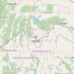
Map view of Phu Kao, Phu Phan Kham National Park

Use this park location map to pinpoint Phu Kao, Phu Phan Kham National Park in Thailand, understand its exact geographic position, and read its mapped placement within the surrounding landscape more clearly.

Pigeon | © OpenStreetMap contributors

Location context for Phu Kao, Phu Phan Kham National Park

Khon Kaen ProvinceNong Bua Lamphu Province
Park atlas

Trace the broader geographic context and compare protected landscapes surrounding Phu Kao–Phu Phan Kham National Park.

Discover Other National Parks and Protected Areas Near Phu Kao–Phu Phan Kham National Park
Explore other national parks and protected areas surrounding Phu Kao–Phu Phan Kham National Park, expanding your view of Thailand's diverse conservation landscapes. Compare their mapped geography and unique protected features to understand regional connections, offering valuable insights into shared terrain and ecological zones.
Green fields, trees, and pink-hued mountains in a watercolor landscape
National parkKhon Kaen Province

Nam Phong National Park: Mapped Protected Landscape and Geography in Khon Kaen Province

Explore scenic viewpoints, rock formations, and reservoir landscapes.

Nam Phong National Park presents a compelling case study in protected landscape geography, particularly within Thailand's northeastern region. This national park is defined by its mountainous terrain, featuring the Phu Phan Kham and Phu Meng ranges that dramatically meet the waters of the Ubol Ratana Dam reservoir. Its mapped boundaries encompass striking viewpoints like Hin Chang Si, prehistoric rock paintings, and geological formations, offering a detailed look at its natural and archaeological significance for atlas exploration.

Area
197 km²
Established
2000
IUCN
II
Visitors
68.3K annual
National parkKhon Kaen Province

Phu Wiang National Park: Detailed Protected Landscape and Regional Geographic Context

Explore mapped park boundaries and natural terrain in Khon Kaen Province.

Phu Wiang National Park serves as a vital component of Thailand's protected areas network, situated within the geographic landscape of Khon Kaen Province. This entry facilitates a detailed atlas-style examination of the park's identity as a national park, focusing on its geographic footprint and the surrounding regional context. Users can trace the protected landscape's features and understand its place within the broader mapped terrain of northeastern Thailand.

Area
325 km²
Established
1965
IUCN
II
Visitors
6.2K annual
National parkThailand

Phu Pha Man National Park: Dramatic Cliffs, Caves, and Dinosaur Tracks in Thailand's Protected Landscape

Explore mapped geography and prehistoric fossil sites within Thailand's Phu Pha Man National Park.

Phu Pha Man National Park is a protected area in Thailand distinguished by its rugged limestone formations, significant cave networks, and dramatic waterfalls. Beyond its scenic beauty, the park is a globally important site for paleontology, holding Asia's oldest known dinosaur tracks. This page provides an atlas-style view of its protected landscape, local geography, and the unique prehistoric discoveries that define its identity.

Area
350 km²
Established
2000
IUCN
II
Visitors
9.7K annual
National parkLoei Province

Phu Kradueng National Park: Sandstone Mesa Protected Landscape and Geographic Atlas

Discover mapped boundaries and pine savanna terrain.

Phu Kradueng National Park, situated in Loei Province, Thailand, is a remarkable protected area defined by its large sandstone mesa and striking cliff-edged summit plateau. This page offers detailed geographic insights into the park's unique landscape, including its pine savanna ecosystems, diverse forest types transitioning from lower slopes to the summit, and its cool, refreshing climate. Explore Phu Kradueng National Park's mapped boundaries and natural terrain for a deeper understanding of this significant conservation landscape.

Area
348 km²
Established
1962
IUCN
II
Visitors
86.3K annual
National parkThailand

Tat Ton National Park: Thailand's National Park Geography and Mapped Landscape

Explore its protected boundaries and natural terrain.

Delve into the specifics of Tat Ton National Park, a protected natural area in Thailand. This page provides a detailed exploration of its mapped boundaries, regional geography, and the character of its natural terrain. Understand its value as a national park for understanding the distribution of protected landscapes and how they contribute to the overall geographic context of Thailand.

Area
217 km²
Established
1980
IUCN
II
Visitors
388.7K annual
National parkPhetchabun Province

Nam Nao National Park: Protected Landscape and Regional Geography

Explore maps and natural terrain of this Northern Thailand park.

Nam Nao National Park, situated in Phetchabun Province, Thailand, is a large national park distinguished by its rugged mountainous terrain and extensive pine forest landscapes. This protected area is vital for its role in conservation, housing significant biodiversity and forming a natural boundary between regions. Through its mapped geography and diverse natural settings, Nam Nao National Park offers a key destination for understanding protected land dynamics and regional natural landscapes.

Area
966 km²
Established
1972
IUCN
II
Visitors
31.8K annual
National parkPhetchabun Province

Tat Mok National Park: A National Park within Phetchabun Province's Mapped Landscapes

Exploring its protected land and regional geographic context.

Tat Mok National Park is a designated national park offering rich opportunities for geographic discovery. Situated in Thailand's Phetchabun Province, this protected area contributes to the region's atlas of natural landscapes. Users can explore the mapped boundaries and understand the park's place within the broader geography of Phetchabun, highlighting its role as a conservation landscape within Thailand.

Area
290 km²
Established
1998
IUCN
II
Visitors
17.9K annual
National parkSakon Nakhon Province

Phu Phan National Park: Thailand's Protected Mountain Landscape and Natural Atlas Entry

Explore dry dipterocarp forest and unique terrain in Sakon Nakhon.

Phu Phan National Park offers a detailed look into Thailand's northeastern geography, characterized by its mountainous terrain and extensive dry dipterocarp forests. As a national park, it represents a vital protected landscape within Sakon Nakhon Province, showcasing unique geological formations and providing a rich context for atlas-based exploration. Discover the park's mapped boundaries, its ecological significance, and the distinct natural features that define this prominent Isan region protected area.

Area
665 km²
Established
1972
IUCN
II
Visitors
4.9K annual

Common questions about visiting, size, designation, and location context for Phu Kao, Phu Phan Kham National Park

Phu Kao, Phu Phan Kham National Park FAQs for park facts, access, geography, and protected area context
Find quick answers about Phu Kao, Phu Phan Kham National Park, including protected-area facts, park geography, trail and visitor context, and how the park fits into its surrounding country and regional landscape.
MoriAtlas Explorer

Continue Your Protected Areas Search Across the Global Atlas

Deepen your exploration by continuing the structured search for national parks and protected areas worldwide. Utilize the comprehensive filtering capabilities to compare different conservation landscapes and refine your understanding of global park geography. Discover more about the distribution and characteristics of protected natural areas.

Global natural geography