Peaks
Cerro Largo
322 m

Detailed terrain analysis including elevation, riverine networks, and protected area spans.
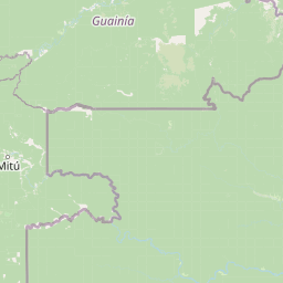
Analyze the physical geography of Puinawai Natural Reserve located in the Guainía Department of Colombia. This profile maps the 10925 square kilometer protected area, detailing its tropical forest, savanna landscapes, and complex river systems. Review recorded elevations ranging from 200 to 380 meters alongside internal landmarks like Cerro Cangrejo and the Río Inírida.
Related tags
Vast Amazon wilderness in far northeastern Colombia
Puinawai Natural Reserve is the second-largest national park in Colombia, encompassing a vast stretch of pristine Amazon rainforest in the remote Guainía Department along the country's eastern border with Venezuela. Established in September 1989, this protected area covers approximately 10,925 square kilometres, representing roughly 15% of the entire Guainía Department. The reserve occupies a critical position in the Amazon basin, where three major river systems converge and where the ecosystems transition between equatorial rainforest and tropical savanna. Despite its enormous size, the reserve remains largely inaccessible and uninhabited, with only about 1% of its area affected by deforestation, making it one of the most intact protected landscapes in Colombia.
Territorial tracking within the Guainía Department of Colombia
Mapped spatial geometry and calculated regional coverage metrics
Lowland relief classification and recorded natural features
Peaks
322 m
Rivers
Wetlands
Peaks
922 m
Waterfalls
Peaks
374 m
Tropical lowland forest and riverine habitats across recorded terrain classifications
Forest · Rivers · Grassland
Tropical forest · Savanna · Riverine habitat
Map the regional spread of protected areas and conservation landscapes surrounding Puinawai Natural Reserve.
Northeast

Discover the dramatic plateau landscapes and unique flora of this protected national park.
Delve into the distinct geography and protected landscape identity of Yapacana National Park, a significant national park within Venezuela's Amazonas region. This page serves as a comprehensive atlas entry, detailing the park's core features, including its iconic Yapacana hill, a dramatic tepui formation representative of the ancient Guayana Shield. Understand the park's geological heritage and its exceptional botanical value, marked by unique floristic connections, all within the context of its Amazonian basin setting.
North

Explore the geography and savanna terrain of this Orinoco basin national park.
El Tuparro National Natural Park stands as a significant protected area in the Vichada Department, embodying the ecological richness of Colombia's Llanos Orientales. Its landscape comprises extensive tropical savannas, striking gallery forests along major rivers like the Orinoco, and dramatic rapids. This page provides an atlas-focused view of El Tuparro National Natural Park, detailing its geographic boundaries and its importance as a conservation corridor within the region, crucial for understanding South American protected lands.
East
Explore its mist-shrouded peaks and deep canyons.
Serranía de la Neblina National Park is a paramount protected area in Venezuela's Amazonas state, famed for its highest tepui mountain. Established in 1978, this vast national park sprawls across 13,600 square kilometers of untamed Amazonian terrain. Its iconic Serranía de la Neblina is continuously wrapped in fog, presenting a unique landscape rich in endemic species and geological wonders like the Baría Grande Canyon. Discover its mapped geography and critical role in Guayanan Highlands conservation.
Northeast
A vital protected monument in the Amazonas region of Venezuela
Discover the geological significance of Monumento natural Piedra la Tortuga, where ancient Precambrian granite formations rise above tropical savannas and gallery forests. This protected area preserves a unique concentration of indigenous history, including major petroglyphs and burial sites, while supporting diverse bird species and riparian ecosystems within the Amazonas region.
East
Mapping the highland ecosystems and river systems of Amazonas
Parque nacional Duida-Marahuaca protects a vast expanse of remote wilderness, anchored by the prominent Cerro Duida, Cerro Huachamacari, and Cerro Marahuaca. This site offers deep insights into the park's sandstone topography and hydrological connectivity within the broader Guayana Shield, providing a clear geographic understanding of these isolated table-top mesas and their surrounding forest habitats.
East
Explore its vast geographic extent and critical Orinoco River basin landscape.
Parima Tapirapecó National Park is an expansive protected territory in Venezuela's Amazonas region, holding the title of the country's largest national park and ranking among the world's most significant protected lands. Its geography is defined by the ancient Guayanan Highlands, protecting the vital headwaters of the Orinoco River and a mosaic of tropical forests and savannas. This park offers deep insights into landscape preservation on a grand scale, crucial for understanding regional geography and protected area distribution.
West
Explore protected land and mapped terrain within Colombia.
Chiribiquete National Park offers a crucial point for exploring Colombia's protected natural areas. As a national park, its geographic scope and mapped landscape provide valuable context for understanding conservation efforts and regional geography. This page serves as an atlas entry, detailing the park's boundaries and its importance within the broader South American context.
East
Guiana Shield Geography and Cloud Forest Ecosystems
Duida, Marahuaca National Park in southern Venezuela is a protected national park defined by its spectacular tepui mountains and unique Guiana Shield geography. This park offers a glimpse into remote wilderness, characterized by dramatic sandstone formations and isolated cloud forest ecosystems that harbor endemic species. Understand the mapped extent and geographic context of this remarkable protected landscape, vital for comprehending regional natural heritage and evolutionary distinctiveness.
Delve deeper into the protected landscape of Puinawai Natural Reserve, understanding its precise geographic context within Guainía Department. Explore the mapped terrain, understand its position at the Amazon-Orinoco hydrological divide, and appreciate its significance as a vast, intact natural reserve for comprehensive atlas exploration.