
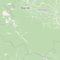
Streams
Park geography
Structured landscape data covering provincial administrative context and regional terrain.
Comprehensive Geographic Profile and Mapped Boundaries of Salonga National Park
Examine the technical geographic specifications of Salonga National Park, including its expansive 36,000 square kilometer boundary. This profile details the park distribution across the Kasaï, Sankuru, Équateur, and Mai Ndombe provinces, highlighting essential riverine systems, forest cover, and wetland terrain characteristics defined within its primary map extent.
Related tags
tropical rainforestUNESCO World Heritage Sitebonobo habitatCongo Basinprimate sanctuary
Africa's largest tropical rainforest reserve and a UNESCO World Heritage Site in the heart of the Congo Basin
Salonga National Park
Salonga National Park is a vast protected area in the Democratic Republic of the Congo, spanning approximately 36,000 square kilometers across the provinces of Mai Ndombe, Equateur, Kasaï, and Sankuru. Established in its current form in 1970, the park protects the largest tropical rainforest in Africa and the second-largest in the world, forming a critical component of the Congo Basin ecosystem. Inscribed on the UNESCO World Heritage List in 1984, Salonga represents one of the most significant biodiversity hotspots on the African continent, harboring numerous endemic and endangered species including the bonobo, Congo peafowl, and forest elephant. The park's interior remains largely inaccessible, with no road network within its boundaries and most regions reachable only by navigating its network of rivers. Due to challenges posed by civil conflict and poaching, the site was placed on the List of World Heritage in Danger from 1999 until 2021, when improved conservation efforts led to its removal from endangered status.
- Location
- Democratic Republic of the Congo
- Park type
- National park
- Established
- 1970
- Area
- 36,000 km²
Location overview
Regional distribution across four provinces in DR Congo
Geographic Location of Salonga National Park in DR Congo
Salonga National Park lies in the Democratic Republic of the Congo, across Kasaï, Sankuru, Équateur, and Mai Ndombe. Official records confirm a mainland, non-transboundary status within a single sovereign territory.
- Countries
- Democratic Republic of the Congo
- Regions
- Équateur Province, Kasaï Province, Mai Ndombe Province, Sankuru Province
- Primary location
- Democratic Republic of the Congo
- Geographic setting
- Inland
Boundary and coordinates
Interactive boundary geometry and calculated geographic measurements
Salonga National Park Boundary Map and Spatial Extent
Mapped park outlines provide spatial context for the protected area and its surrounding terrain. Accompanying facts detail the recorded area, coordinate limits, geographic spans, and central positioning.
- Boundary area
- 33,338.5 km²
- Boundary perimeter
- 1,867.7 km
- Northernmost point
- 1.0207° S
- Southernmost point
- 3.3164° S
- Easternmost point
- 22.6585° E
- Westernmost point
- 20.1122° E
- Geographic centre
- 2.1472° S, 21.3206° E
- North–south span
- 253.9 km
- East–west span
- 283.2 km
Terrain and natural features
Lowland relief classifications and recorded hydrographic features
Salonga National Park Terrain and Named Natural Features
Stored lowland terrain classifications define the regional landscape alongside recorded river networks and forest zones. Linked feature cards supply specific names, types, measurements, and spatial relationships.
Selected named natural features
Rivers
Ilonga-Djali
Rivers
Lokolo
Forests
RSouth
Rivers
Lokoro River
Rivers
Salonga
Environmental setting
Analysis of tropical forest cover, lowland relief, and riverine habitats
Salonga National Park Environmental Classification and Physical Setting
Recorded landscape features, tropical climate zones, and dominant forest cover provide complementary ways to read the physical setting of Salonga National Park. Stored classifications connect directly to relevant atlas destinations across the protected area.
- Relief
- Lowland
- Climate
- Tropical
- Water
- Major water bodies
- Forest cover
- Dense forest cover
Landscape features
Forest · Rivers · Wetland
Habitat types
Temperate broadleaf forest · Tropical forest · Wetland · Riverine habitat
Park atlas
Explore the Regional Context and Conservation Landscapes Surrounding Africa's Largest Tropical Rainforest.
Discover Other National Parks and Protected Areas Near Salonga National Park
Browse a curated selection of national parks and protected areas across the Congo Basin, offering geographic and ecological context to Salonga National Park's vast rainforest. Compare diverse conservation landscapes throughout the region, tracing the spread of significant wildlife habitats and unique ecosystems from an atlas perspective.
National parkDemocratic Republic of the Congo
202 km away#1 closest
East

Lomami National Park: Central African Protected Landscape and Biodiversity Hub
Explore its lowland tropical rainforest and distinct bonobo habitat.
Lomami National Park is a recently established national park in the Democratic Republic of the Congo, covering nearly 9,000 square kilometers of lowland tropical rainforest. Situated in the central Congo Basin, it plays a crucial role in protecting unique biodiversity, including genetically distinct bonobo populations separated by the Lomami River. The park also supports populations of okapi and the Congo peafowl, making it a vital area for conservation and geographic discovery within Central Africa.
- Area
- 8,879 km²
- Established
- 2016
- IUCN
- II
- Relief
- Mixed relief
National parkCongo
About 461 km away#2 closest
Northwest

Ntokou-Pikounda National Park: Congo's Protected Landscape and Regional Geographic Atlas
Explore the mapped boundaries of this national park in Congo.
Ntokou-Pikounda National Park serves as a critical point of reference for understanding protected landscapes in Congo. As a national park, its geographic scope and mapped boundaries are essential for atlas-based discovery. This detailed entry facilitates an exploration of its protected terrain and regional context, highlighting its significance within the broader conservation geography.
- Area
- 4,572 km²
- Established
- 2012
- IUCN
- II
- Relief
- Lowland
National parkDemocratic Republic of the Congo
481 km away#3 closest
East
Maiko National Park National Park: Map and Protected Landscape Exploration
Discover primary forest terrain and endemic species sanctuary.
Maiko National Park, situated in the Democratic Republic of the Congo, is a cornerstone of central African conservation, protecting over 10,000 square kilometers of pristine tropical rainforest. This national park is recognized globally for its critical role in harboring endemic species such as Grauer's gorilla and the okapi, alongside significant populations of forest elephants and chimpanzees. Its extensive river systems and varied terrain within the Ituri Rainforest ecosystem provide essential habitat, establishing Maiko as a key area for understanding and preserving central African biodiversity and landscape context.
- Area
- 10,885 km²
- Established
- 1970
- IUCN
- II
- Relief
- Mixed relief
National parkSouth Kivu Province
538 km away#4 closest
East
Kahuzi-Biéga National Park: Protected Mountain and Rainforest Geography in South Kivu
Mapped terrain from volcanic summits to equatorial forest basins.
Kahuzi-Biéga National Park represents a significant protected area within the South Kivu Province. The geography features two distinct sectors connected by a narrow ecological corridor, encompassing everything from high-altitude subalpine heather zones to dense tropical lowland environments. This dataset provides a detailed look at the park boundaries, volcanic topography, and the regional landscape context that defines this essential habitat.
- Area
- 6,000 km²
- Established
- 1970
- IUCN
- II
- Relief
- Mixed relief
National parkCongo
555 km away#5 closest
Northwest
Nouabalé-Ndoki National Park: Congo National Park & Protected Landscape Atlas
Explore protected area geography and mapped terrain.
Nouabalé-Ndoki National Park is a designated national park in Congo, offering rich opportunities for geographic discovery and atlas exploration. This page details the park's protected landscape, its mapped boundaries, and its significance within the regional geography of Congo. Users can investigate the park's natural terrain and its place within the broader atlas of protected areas.
- Area
- 3,921.61 km²
- Established
- 1993
- IUCN
- II
- Relief
- Lowland
National parkCuvette-Ouest Department
586 km away#6 closest
Northwest
Odzala-Kokoua National Park National Park: Mapped Protected Landscape in Cuvette-Ouest
Explore its geographic boundaries and regional terrain.
Odzala-Kokoua National Park is a key national park entity, offering a distinct protected landscape within the Cuvette-Ouest Department. This page provides an atlas-style exploration of its mapped boundaries and geographic context. Delve into the specifics of this protected area to understand its contribution to the regional geography and natural landscape, facilitating structured discovery of its terrain.
- Area
- 13,500 km²
- Established
- 1935
- IUCN
- II
- Visitors
- 50 annual
National parkCameroon
620 km away#7 closest
Northwest

Lobéké National Park National Park: A Protected Landscape within the Congo Basin
Explore its semi-evergreen forest, unique bais, and riverine ecosystems.
Lobéké National Park represents a core protected national park within the vast Congo Basin, renowned for its exceptionally high densities of African forest elephants and western lowland gorillas. Covering over 2,000 square kilometers of largely untouched semi-evergreen forest, the park features distinct ecosystems including mineral-rich bais clearings, saline swamp savannas, and diverse riverine habitats. As a crucial component of the Sangha Trinational protected area, Lobéké National Park offers a profound look into Central African wilderness and its unique natural geography.
- Area
- 2,178 km²
- Established
- 1999
- IUCN
- II
- Relief
- Lowland
National parkCentral African Republic
620 km away#8 closest
Northwest

Dzanga-Ndoki National Park National Park: Mapped Boundaries and Geographic Context in Central Africa
Explore protected landscape geography and park atlas details.
Gain a structured understanding of Dzanga-Ndoki National Park as a protected area in the Central African Republic. This page focuses on its precise geographic scope, mapped park boundaries, and its identity as a National Park. It serves as an entry point for exploring the park's landscape context and its place within the atlas of protected natural areas, offering factual details for geographic discovery.
- Area
- 1,143.26 km²
- Established
- 1990
- IUCN
- II
- Relief
- Lowland
MoriAtlas Explorer
Continue Exploring Salonga National Park's Unique Geographic and Landscape Context
Delve deeper into the mapped terrain and protected area geography of Salonga National Park. Understanding its role as a vital ecosystem within the Congo Basin and its significance for species like the bonobo provides essential context for geographic exploration. Continue to discover the rich, detailed atlas information available for this premier African protected landscape.
Browse next
Global natural geography
Explore related park routes
Explore MoriAtlas Global ParksBrowse All MoriAtlas ParksGlobal Park Map DiscoveryMoriAtlas: Browse All CountriesBrowse All MoriAtlas ContinentsNational Park Environment AtlasGrand Canyon National Park AtlasYellowstone National Park AtlasYosemite National Park Atlas and GeographySerengeti National Park AtlasGalápagos National Park Protected LandscapeBanff National Park Geography and AtlasKruger National Park Atlas EntryUluṟu-Kata Tjuṯa National Park AtlasExplore Uluru-Kata Tjuta National Park GeographyPlitvice Lakes National Park AtlasFiordland National Park Protected LandscapeGreat Smoky Mountains National Park AtlasAfghanistan National Parks and Protected AreasAlbania National Parks and Protected AreasAlgeria National Parks and Protected AreasAmerican Samoa National Parks and Protected AreasAndorra National Parks and Protected AreasAngola National Parks and Protected AreasAntarctica National Parks and Protected AreasAntigua and Barbuda Park List