

Mori Atlas logo
Protected landscapeSkipsfjord landskapsvernområde

A comprehensive atlas view of coastal fjord terrain, salmon rivers, and mountain catchment zones

Skipsfjord landskapsvernområde: Mapped Protected Landscape Geography in Northern Troms, Norway

Skipsfjord landskapsvernområde preserves a distinct outer-coast environment on the island of Vanna, where marine basins, flat valley floors, and rugged mountain slopes converge. This protected area in Troms encompasses an undisturbed river system, extensive cloudberry mires, and significant coastal cultural heritage sites. Use this geographic record to analyze the natural boundaries and environmental composition of one of Norway's most defined northern coastal protected landscapes.

landscape protection areaouter coast Tromsfjord landscapecoastal cultural landscapecloudberry miressalmon river
A digital illustration showing a coastal scene with a steep, rocky cliff overlooking a calm fjord, green grassy slopes in the foreground, and small cabins near the water.

Skipsfjord landskapsvernområde

Protected landscape

Park overview

Structured park overview, official facts, and landscape profile for Skipsfjord Landscape Protection Area

Skipsfjord Landscape Protection Area park facts, protected area profile, and essential visitor context

Review the core facts for Skipsfjord Landscape Protection Area, including designation, size, terrain, visitor scale, habitats, and operating context in one park-focused overview.

About Skipsfjord Landscape Protection Area

Skipsfjord landskapsvernområde is one of several landscape protection areas that together capture the diversity of Norway's outer coastline, focusing here on the Troms region and more specifically the island of Vanna in Karlsøy municipality. The reserve cuts across a distinctive cross-section of northern Norwegian coastal geography, from sheltered fjord shoreline across a soft, valley floor and up into steeper mountain slopes that drain into the same catchment.

The protection area was designated in December 1978 with the explicit goal of preserving a beautiful natural area of cultural landscape typical of the outer coastal districts of Troms, together with an undisturbed watercourse, geologically interesting deposits, and a characteristic, partly rich plant and animal life. The protected boundary follows a line between Skotallneset and Kvalkjeften across the fjord and continues inland to include Skipsfjorddalen and the parts of the mountains on Vanna whose waters drain into Skipsfjord.

In practice the reserve functions as a single ecological landscape unit: a fjord, a valley, and a mountain catchment joined by one river system. This makes it a compact example of how Norwegian coastal landscape protection under the older landskapsvernområde category is meant to preserve whole, interconnected land-sea units rather than isolated fragments. The combination of cultural landscape elements, an undisturbed river, and a broad natural context also gives the area a clear research and monitoring value.

Quick facts and research context for Skipsfjord Landscape Protection Area

Skipsfjord landskapsvernområde lies in Karlsøy municipality in Troms county, northern Norway, on the island of Vanna. It was formally protected on 15 December 1978 as a landscape protection area with plant-life protection. The reserve includes around 54.1 square kilometers of land area and approximately 10.7 square kilometers of sea area, extending from the inner Skipsfjord across Skipsfjorddalen and the adjacent mountain catchment on Vanna.

The protection purpose explicitly combines the preservation of a typical outer-coast cultural landscape, an undisturbed watercourse, geologically interesting deposits, and a characteristic, partly rich flora and fauna. Wildlife inventories by NINA in 2004 recorded 72 bird species and 12 mammal species in the area, including 13 red-listed bird species and one red-listed mammal, the Eurasian otter.

Protection and recognition

Review documented protection scope and international recognition details for Skipsfjord landskapsvernområde.

Skipsfjord landskapsvernområde Protection Status and Recognized Conservation Frameworks

Skipsfjord landskapsvernområde features a mixed protection scope outlining its formal conservation framework and management context. Official records detail the protected area designation and associated recognition sources without external assumptions.

Protection details

Protection scope
Mixed
Transboundary protection
No
Park context

Deeper park guide and search-rich context for Skipsfjord Landscape Protection Area

Skipsfjord Landscape Protection Area history, landscape, wildlife, and travel context

Explore Skipsfjord Landscape Protection Area through its history, landscape character, ecosystems, wildlife, conservation priorities, cultural context, and seasonal travel timing in a structured park guide built for atlas discovery and search intent.

Why Skipsfjord Landscape Protection Area stands out

Skipsfjord landskapsvernområde is best known for holding a representative picture of the outer coast of Troms, where a sheltered fjord with abandoned farms, a wide valley of cloudberry mires, and the salmon-bearing Skipsfjordelva meet the rugged mountain slopes of Vanna. It is also recognized for its biological richness on a relatively small geographic scale, with surveys identifying dozens of bird species and several red-listed animals within the same protected area. The reserve is further valued for combining cultural landscape value with ecological value: the three former farms of Røyrnes, Skipsfjord, and Nygård frame a landscape that has shifted from active agricultural use to recreational use, while the surrounding terrain retains undisturbed vegetation, mires, and shoreline habitats.
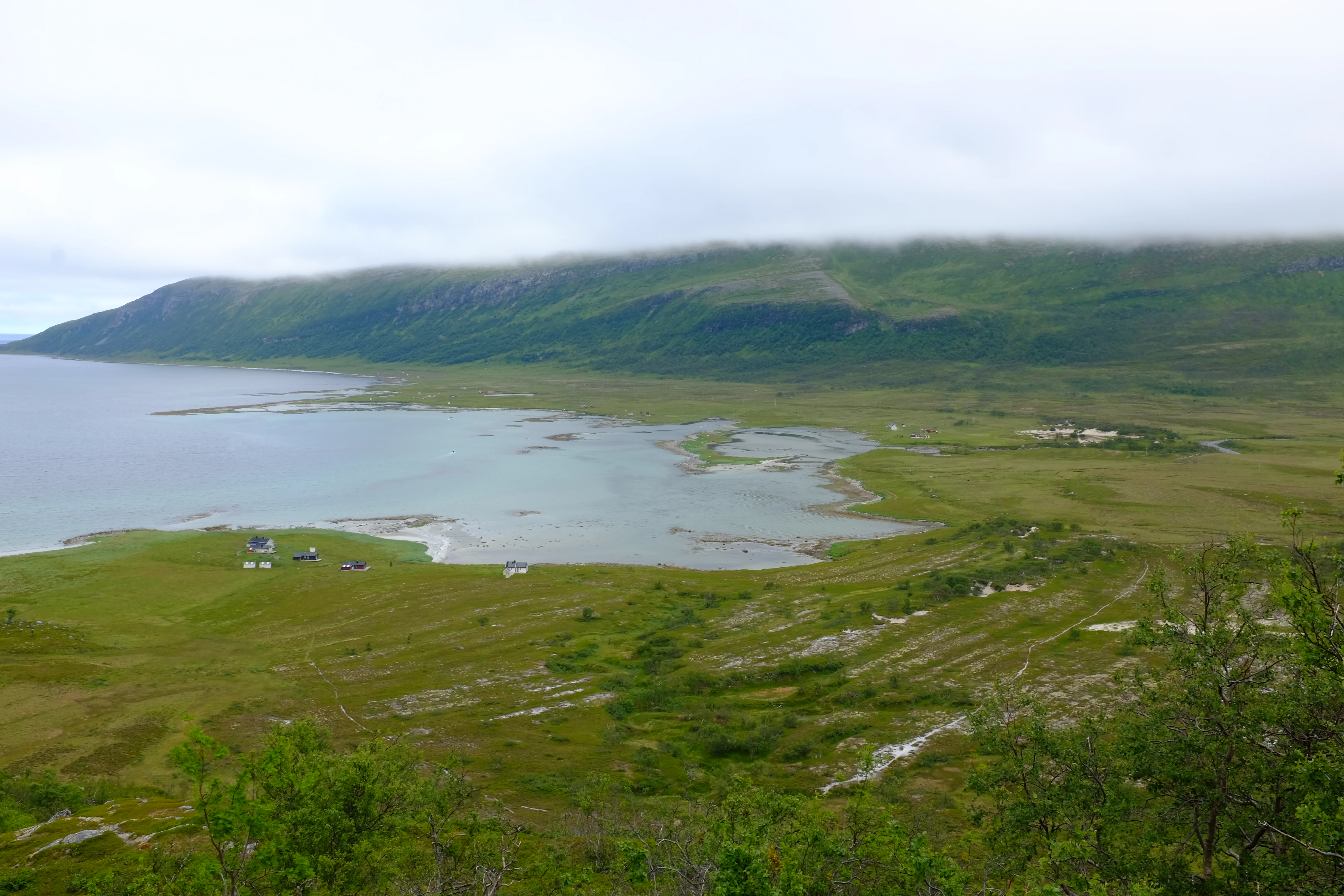
A high-angle view of a calm bay with grassy shores, small buildings in the distance, and low-lying mountains covered in clouds.
A view over the Skipsfjorden bay and surrounding coastal terrain.

Skipsfjord Landscape Protection Area history and protected-area timeline

Skipsfjord landskapsvernområde was formally established on 15 December 1978 as a landscape protection area with associated plant-life protection. Its designation came at a period when Norway was strengthening protection of representative coastal and fjord landscapes and was explicitly framed around preserving an outer-coast cultural landscape together with natural values such as the undisturbed Skipsfjordelva and scientifically interesting geological deposits.

The reserve takes in three former farms along the inner Skipsfjord shoreline: Røyrnes, lying furthest west near the river mouth; Skipsfjord itself, at the river estuary; and Nygård, north of the others. These farms have not been in active agricultural use since 1967 and now serve mainly as holiday properties, with a number of more recently built cabins also present in the area. This shift from working farming settlement to recreational use is an important part of the reserve's modern cultural landscape story.

Later biological and habitat surveys added to the documented history of the area. The Norwegian Institute for Nature Research, NINA, conducted a detailed wildlife mapping of the reserve in 2004, recording 72 bird species and 12 mammal species within the landscape protection area and providing much of the baseline data that frames the site's present conservation profile.

Skipsfjord Landscape Protection Area landscape and geographic character

The physical landscape of Skipsfjord landskapsvernområde divides into three clearly defined zones. The marine zone is the inner basin of Skipsfjorden, protected out to a line between Skotallneset and Kvalkjeften and including roughly 10.7 square kilometers of sea area as part of the reserve. The fjord shoreline here features the strandflaten, the low, flat coastal shelf typical of Norway's outer coast, on which the former farms sit.

The valley zone is Skipsfjorddalen, a relatively flat valley floor that is well known for its extensive cloudberry mires and for being a productive area for willow ptarmigan hunting. Running through the valley is the Skipsfjordelva, a salmon-bearing river whose undisturbed course was explicitly mentioned in the protection purpose and that broadens near the coast into a small estuary next to the Skipsfjord farm site.

Above the valley, the mountain zone rises into the southern and southeastern parts of Vanna, including the high ground whose runoff drains westward into Skipsfjord. Together the fjord, flat valley, and surrounding peaks form a compact cross-section of outer Troms geology, with cited geological deposits of scientific interest included in the formal purpose of the reserve.

Skipsfjord Landscape Protection Area ecosystems, habitats, and plant life

Ecologically, Skipsfjord landskapsvernområde is structured around the interaction between marine shoreline, freshwater valley wetland, and mountain catchment. The Skipsfjord valley flora is shaped by extensive mires, particularly cloudberry-dominated wetlands that give the valley floor its notable habitat character, while the shoreline supports salt-influenced vegetation on the strandflaten and around the three former farm sites.

The river system of Skipsfjordelva and its tributaries provides a continuous gradient from coastal brackish conditions up through freshwater mire and stream habitats into mountain runoff, all of which lie within the protected boundary. This continuity is one of the reasons the reserve was singled out for its undisturbed watercourse.

On the broader landscape scale, the reserve contains both open mire communities, valley meadows shaped by past grazing and mowing, freshwater shoreline, marine shoreline, low alpine vegetation, and bare mountain ground. These varying habitats, concentrated within a relatively small reserve, are central to the ecological value of the area and support the documented richness of its bird and mammal fauna.

Skipsfjord Landscape Protection Area wildlife and species highlights

Wildlife in Skipsfjord landskapsvernområde has been studied in a dedicated NINA survey from 2004, which registered 72 bird species and 12 mammal species within the landscape protection area. Of these, 13 bird species and one mammal species, the Eurasian otter, are on the Norwegian Red List, giving the relatively small area a notable share of red-listed species.

The recorded bird groups span a wide range of northern coastal and mountain species. Loons, cormorants, grey herons, ducks, white-tailed eagles, hawks, falcons, willow ptarmigan, waders, gulls and auks, the common cuckoo, owls, and passerines were all documented. This mix reflects the meeting of marine, shoreline, mire, valley, and mountain habitats within the same reserve.

Among mammals, the survey notes Eurasian otter, stoat, American mink, moose, domestic reindeer, mountain hare, Norwegian lemming, field vole, and several seal species including grey seal, harbour seal, ringed seal, and bearded seal. The presence of moose and domestic reindeer alongside shoreline seals and otters ties together the valley, mountain, and marine components that define the reserve.

Skipsfjord Landscape Protection Area conservation status and protection priorities

The conservation significance of Skipsfjord landskapsvernområde lies in its combination of an undisturbed river, a representative outer-coast cultural landscape, and rich biological diversity within a single protected unit. The formal purpose of the reserve, as recorded at its establishment, places equal weight on protecting a beautiful natural area, the watercourse, geological deposits of scientific interest, and characteristic flora and fauna.

A detailed wildlife inventory by the Norwegian Institute for Nature Research in 2004 documented 72 bird species and 12 mammal species in the landscape protection area, with 13 bird species and one mammal species, the Eurasian otter, holding red-listed status. The presence of nearby seal species in the marine portion adds a marine dimension to the red list profile.

The area also has documented habitat and land-cover references through the Norwegian Institute of Forest and Landscape's Markslagsstatistikk and through NINA's biological diversity report for Karlsøy municipality. Together these resources make the reserve an established reference site for understanding how cultural landscape, mire valley, and outer-coast fjord ecosystems interact in northern Norway.

Skipsfjord Landscape Protection Area cultural meaning and human context

The cultural layer of Skipsfjord landskapsvernområde is anchored in three former coastal farms along the inner shore of Skipsfjorden: Røyrnes furthest west, Skipsfjord at the river estuary, and Nygård to the north. All three were farmed together and have been out of active agricultural use since 1967, since when the buildings have been used for recreation and holiday purposes.

The presence of these abandoned farms within a protected natural area is central to the reserve's identity as an outer-coast cultural landscape. The earlier mix of small-scale agriculture, livestock grazing on surrounding meadows, and use of the valley and shoreline for hunting and fishing has left visible traces in the terrain and continues to shape the character of today's recreational landscape. Modern additions to the area include a number of newer cabins that sit alongside the older farm structures.

Top sights and standout views in Skipsfjord Landscape Protection Area

Skipsfjord landskapsvernområde stands out for the way a small protected area integrates fjord, valley, mountain, and river within a single boundary. The Skipsfjord valley floor is rich in cloudberry mires and is known as productive willow ptarmigan hunting terrain, while the salmon-bearing Skipsfjordelva runs uninterrupted through the protected catchment.

The reserve is also notable for the mix of an abandoned coastal farming settlement, now used for recreation, alongside red-listed species such as the Eurasian otter and thirteen bird species on the Norwegian Red List. The 2004 NINA survey that recorded 72 bird species and 12 mammal species underlines how biological richness and cultural landscape values meet here on the outer coast of Troms.

Best time to visit Skipsfjord Landscape Protection Area

Skipsfjord landskapsvernområde is most rewarding when the conditions of the northern Norwegian coastal calendar are taken into account rather than a fixed calendar window. Summer brings the long northern daylight hours, easier access by boat along the coast, and the period when valley mires and shoreline vegetation are most visible, while also being the time when seabirds, waders, and other coastal birdlife are most active around the fjord and the strandflaten.

Early autumn is the traditional period for willow ptarmigan hunting in the Skipsfjord valley, and it is also when the cloudberry mires are typically harvested. Winter brings snow cover, very short daylight, and limited access to the inner fjord farms and valley, but it is also the season that frames the surrounding mountain slopes on Vanna. Visitors should generally expect conditions typical of the outer Troms coast and plan around weather and daylight rather than a single optimal month.

Monthly climate preview

Long-term temperature ranges and monthly precipitation patterns sampled at representative elevations

Skipsfjord landskapsvernområde Climate Normals and Annual Weather Rhythms

Historical data records monthly temperature variations and precipitation averages measured at a representative coordinate within Skipsfjord landskapsvernområde. Examining the complete twelve-month sequence reveals the full range of long-term climatic conditions across the protected landscape.
Annual mean2 °C
-5 °C11 °C
Jan-4°
Feb-5°
Mar-3°
Apr
May
Jun
Jul11°
Aug10°
Sep
Oct
Nov-1°
Dec-3°
Warmest month
July

11.2 °C

Coolest month
February

-4.5 °C

Wettest month
October

4.1 mm/day

Driest month
April

2.7 mm/day

Park location guide

Geography guide, regional context, and park location map for Skipsfjord Landscape Protection Area

Skipsfjord Landscape Protection Area park geography, regions, and map view in Norway

Understand where Skipsfjord Landscape Protection Area sits in Norway through a broader geographic reading of the surrounding landscape, nearby location context, and its mapped position within the national park landscape.

How Skipsfjord Landscape Protection Area fits into Norway

Norway, officially the Kingdom of Norway, is a Nordic country in Northern Europe located on the Scandinavian Peninsula. It encompasses mainland Norway, the Arctic islands of Svalbard and Jan Mayen, and maintains dependencies including Bouvet Island and Antarctic claims. The country has a population of about 5.6 million and is bordered by Sweden, Finland, and Russia. Norway is a unitary parliamentary constitutional monarchy with Oslo as its capital and largest city.

Wider geography shaping Skipsfjord Landscape Protection Area in Norway

Norway occupies the western and northern portions of the Scandinavian Peninsula in Northern Europe. The country shares a long eastern border with Sweden, and borders Finland and Russia to the northeast. Norway has an extensive coastline facing the Skagerrak, North Sea, Norwegian Sea, and Barents Sea. The terrain is predominantly mountainous with numerous fjords along the coastline.

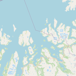
Map view of Skipsfjord Landscape Protection Area

Use this park location map to pinpoint Skipsfjord Landscape Protection Area in Norway, understand its exact geographic position, and read its mapped placement within the surrounding landscape more clearly.

Pigeon | © OpenStreetMap contributors

Location context for Skipsfjord Landscape Protection Area

Troms

Visualizing the outer coast fjords, cloudberry mires, and mountain catchments of northern Norway

Skipsfjord landskapsvernområde Photos and Landscape Scenery

Examine detailed photography of Skipsfjord landskapsvernområde to understand its unique outer-coast terrain, sheltered fjord basins, and sprawling valley mires. Visual records provide essential context for studying the protected habitats, river catchments, and coastal cultural landscapes found across Vanna island.

A high-angle view of a calm bay with grassy shores, small buildings in the distance, and low-lying mountains covered in clouds.

Park atlas

Compare adjacent coastal terrain, regional mountain catchments, and northern Norwegian reserves

Parks Near Skipsfjord Landskapsvernområde and Surrounding Protected Landscapes

Browsing other protected areas near Skipsfjord landskapsvernområde reveals broader ecological patterns across the outer coast of Troms. Evaluating adjacent coastal reserves and regional mountain catchments provides helpful geographical context for northern Norwegian conservation landscapes.
National parkFinnmark
About 117 km away#1 closest

East

Seiland National Park: Arctic Island Landscape and Northernmost Scandinavian Glaciers

Mapped boundaries of protected terrain in Finnmark

Seiland National Park offers a distinct glimpse into Arctic island geography, renowned for protecting Scandinavia's northernmost glaciers. This protected area in Finnmark features a dramatic landscape shaped by glaciated mountains, deep coastal fjords, and alpine terrain, making it a key destination for understanding Nordic natural environments. MoriAtlas facilitates exploration of its mapped boundaries and the unique combination of glacial and marine ecosystems present.

Area
316 km²
Established
2006
IUCN
II
Relief
Mountain
National parkTroms
About 132 km away#2 closest

Southeast

Reisa National Park: Dramatic River Valley and Protected Landscape Atlas

Subarctic terrain and geographic context in Troms, Norway.

MoriAtlas offers detailed geographic context for Reisa National Park, a protected landscape in Norway's Troms county. Explore the park's identity as a significant subarctic river valley, carved by the Reisa River into a dramatic canyon system. This page provides insights into its mapped natural features, regional landscape setting, and its importance within the broader atlas of protected areas. Understand the park's protected boundaries and terrain for structured geographic discovery.

Area
803 km²
Established
1986
IUCN
II
Relief
Mixed relief
National parkTroms
About 142 km away#3 closest

South

Øvre Dividal National Park: Arctic Alpine Protected Landscape in Troms, Norway

Mapped boundaries and unique ecological terrain of a pristine wilderness.

Øvre Dividal National Park stands as a premier example of Arctic alpine wilderness, meticulously preserved as a national park in Norway's Troms region. This entry facilitates a detailed exploration of its mapped protected boundaries and the distinct elevational ecological zones, from boreal forests to high-altitude tundra. Gain geographic context for this vital landscape, which supports diverse habitats and contributes to Scandinavia's largest contiguous wilderness areas.

Area
750 km²
Established
1971
IUCN
II
Relief
Mountain
National parkSenja
About 143 km away#4 closest

Southwest

Ånderdalen National Park: Ancient Coastal Pine Forest and Glacial Valley Landscape

Norway's protected area within the Senja region.

Delve into the detailed protected landscape of Ånderdalen National Park, a national park located on Norway's Senja island. This entry offers a focused atlas exploration of its unique geographic features, including its celebrated ancient coastal pine forest, dramatic glacial valleys carved from granite, and its significance as a representative example of the northern Norwegian coastal mountain terrain. Understand the mapped boundaries and the natural context of this vital conservation area.

Area
134 km²
Established
1970
IUCN
II
Relief
Mixed relief
National parkNorway
About 163 km away#5 closest

East

Stabbursdalen National Park: Protected Arctic Landscape and Northernmost Pine Forest Atlas

Explore Finnmark's unique geography and protected terrain.

Stabbursdalen National Park preserves a remarkable ecological boundary, featuring the planet's northernmost Scots pine woodland within a dramatic Arctic landscape. This protected area offers a deep dive into rugged mountain terrain, river valley formations, and vital wetland habitats. As a key component of Norway's protected lands, it provides essential context for understanding regional geography and the limits of forest ecosystems on the mapped landscape.

Area
747 km²
Established
1970
IUCN
II
Relief
Mixed relief
Watercolor painting depicting mountain peaks, a lake, and grassy areas in the foreground
National parkTroms
About 170 km away#6 closest

South

Rohkunborri National Park: Northern Norway's Dramatic Protected Landscape

Explore its mapped terrain, canyon, and alpine ecosystems.

Rohkunborri National Park offers a profound encounter with northern Norway's wild geography. As a designated national park in Troms county, it features the iconic Sørdalen canyon, a dominant geological feature that shapes its diverse terrain. The park's landscape encompasses a rich ecological gradient, from boreal forests to alpine tundra, supporting a variety of wildlife. This protected area is crucial for understanding Scandinavian mountain ecosystems and transboundary conservation efforts, providing rich content for atlas-based exploration of its mapped boundaries and natural context.

Area
571 km²
Established
2011
IUCN
II
Relief
Mountain
Watercolor illustration showing mountains in the background, a winding river, and vegetation in the foreground
National parkNorrbotten County
About 181 km away#7 closest

South

Vadvetjåkka National Park: Arctic Mountain Landscape and Karst Terrain

Northernmost National Park in Norrbotten County, Sweden

Vadvetjåkka National Park offers a unique atlas perspective on Sweden's northernmost protected mountain landscape. Explore its remote Arctic terrain, characterized by glaciers existing at unusual low altitudes and significant karst cave systems carved into limestone bedrock. This is a vital point for understanding the mapped geography and protected natural features of Norrbotten County and Swedish Lapland.

Area
26.3 km²
Established
1920
IUCN
II
Relief
Mountain
Watercolor painting showing green hills, a body of water, and distant mountains
National parkNorrbotten County
About 198 km away#8 closest

South

Abisko National Park

Subarctic national park with unique landscapes

Abisko National Park in Swedish Lapland offers a glimpse into dramatic subarctic terrain. Explore its protected boundaries, river canyons, and alpine tundra through structured geographic data.

Area
77 km²
Established
1909
IUCN
II
Visitors
50K annual

Common questions about visiting, size, designation, and location context for Skipsfjord Landscape Protection Area

Skipsfjord Landscape Protection Area FAQs for park facts, access, geography, and protected area context

Find quick answers about Skipsfjord Landscape Protection Area, including protected-area facts, park geography, trail and visitor context, and how the park fits into its surrounding country and regional landscape.
MoriAtlas Explorer

Continue Your Protected Areas Search Across the Global Atlas

Deepen your exploration by continuing the structured search for national parks and protected areas worldwide. Utilize the comprehensive filtering capabilities to compare different conservation landscapes and refine your understanding of global park geography. Discover more about the distribution and characteristics of protected natural areas.

Global natural geography