

Mori Atlas logo
National parkTarutao National Park

Discover the mapped boundaries and regional geography of this protected natural area.

Tarutao National Park: A National Park Protected Landscape in Satun Province, Thailand

(อุทยานแห่งชาติตะรุเตา)

Tarutao National Park, designated as a national park, represents a significant protected landscape within Satun Province, Thailand. This entry provides a focused view of its geographic scope and protected-area identity, enabling detailed atlas exploration. Users can explore the park's mapped boundaries and understand its context within the Andaman Sea coast's regional geography.

Marine national parkIsland archipelagoTurtle nesting siteASEAN Heritage ParkCoastal ecosystemsCoral reefs

Tarutao National Park

National park

Park overview

Structured park overview, official facts, and landscape profile for Tarutao National Park

Tarutao National Park park facts, protected area profile, and essential visitor context
Review the core facts for Tarutao National Park, including designation, size, terrain, visitor scale, habitats, and operating context in one park-focused overview.

About Tarutao National Park

Tarutao National Park represents a cornerstone of Thailand's marine conservation infrastructure, established to protect a remarkable archipelago that spans the transition between the Andaman Sea and the Strait of Malacca. The park's 51 islands vary dramatically in character, from the mountainous, forest-covered slopes of Ko Tarutao to the small, sandy atolls that barely rise above sea level. The Tarutao Archipelago, located approximately 30 kilometers from the coast, includes the main island of Ko Tarutao, which at 26.5 kilometers long and 11 kilometers wide is the largest in the park and features peaks exceeding 700 meters in elevation. The Klang Archipelago lies another 8 kilometers offshore, while the Adang-Rawi group sits approximately 50 kilometers west of Tarutao and includes the popular Ko Lipe, a 4-square-kilometer island that supports the largest permanent settlement in the park with approximately 800 residents. The park's position near the Malaysia-Thailand border places it at a strategic intersection of marine ecosystems, and the southernmost reaches of the park lie just north of Malaysia's Langkawi islands. This geographic positioning contributes to the exceptional biodiversity found within the park's waters and on its islands, supporting both tropical marine species and terrestrial organisms adapted to the island environment.

Quick facts and research context for Tarutao National Park

Tarutao National Park is located in Satun Province, southern Thailand, in the Strait of Malacca near the Malaysian border. The park comprises 51 islands organized into two primary groups: the Tarutao Archipelago and the Adang-Rawi Archipelago, scattered 20 to 70 kilometers offshore. The largest island, Ko Tarutao, spans 26.5 kilometers in length and reaches elevations exceeding 700 meters, with over 70% of its terrain covered in forest. Ko Lipe, the most populated island at approximately 800 permanent residents, serves as the primary gateway for boat transportation within the Adang group. The park received 238,409 visitors in 2019 and is managed by Thailand's Department of National Park, Wildlife and Plant Conservation.

Park context

Deeper park guide and search-rich context for Tarutao National Park

Tarutao National Park history, landscape, wildlife, and travel context
Explore Tarutao National Park through its history, landscape character, ecosystems, wildlife, conservation priorities, cultural context, and seasonal travel timing in a structured park guide built for atlas discovery and search intent.

Why Tarutao National Park stands out

Tarutao National Park is best known for its pristine marine environment, diverse island ecosystems, and significant role as a conservation area within the Strait of Malacca. The park protects critical turtle nesting beaches, particularly at Son Bay on Ko Tarutao, where sea turtles come ashore to lay their eggs. The archipelago supports substantial forest coverage on its larger islands, with Ko Tarutao boasting over 70% forest cover including unique inland habitats. The park's historical significance as a former penal colony and its dramatic wartime history as a pirate stronghold add cultural dimension to its natural appeal. The dramatic karst landscapes, coral reefs, and clear turquoise waters surrounding the islands make it a destination of exceptional marine biodiversity.

Tarutao National Park history and protected-area timeline

The history of Tarutao National Park is rich and multifaceted, extending far beyond its 1974 establishment as a protected area. The oldest surviving eyewitness account of the islands comes from Dutch East India Company Admiral Cornelis Matelief de Jonge, whose travelogue from December 1606 and January 1607 provides the earliest documented European description of the archipelago. In the late 1930s, the island served as a penal colony for Thai political prisoners, a period that would later shape the park's wartime history dramatically. During World War II, when Japanese occupation cut off support from the Thai mainland, the guards and prisoners formed an unlikely alliance under the leadership of an American plantation owner who had lost his fortune due to the war. Assisted by two British non-commissioned officers who had escaped custody and arrived at Tarutao to wait out the conflict, the group organized systematic piracy in the surrounding waters. They sank approximately 130 ships passing through the Strait of Malacca, consistently murdering all crew members aboard. After the war ended, British forces eradicated the Tarutao pirates, and the islands subsequently became home to fishermen and farmers who established the communities that remain today. In 1982, the park was designated as one of the original ASEAN Heritage Parks, recognizing its regional conservation significance. The park was submitted to UNESCO for World Heritage listing in 1990, though the World Heritage Committee deferred its inclusion in 1991, requesting stronger management measures for the area.

Tarutao National Park landscape and geographic character

The landscape of Tarutao National Park is characterized by dramatic diversity across its 51 islands, ranging from towering mountainous terrain to low-lying coral atolls. The largest island, Ko Tarutao, features a rugged interior with peaks exceeding 700 meters elevation, covered predominantly by dense forest that comprises over 70% of the island's surface. The western coast of Tarutao features rocky shores and the only bay in the park, Son Bay, which stretches approximately 3 kilometers and serves as a critical turtle nesting site. The landscape includes the unique Luu Doo Waterfall, the only waterfall within the park, which cascades into Son Bay and features notable underwater rock formations. The Adang-Rawi group of islands presents different terrain, with Ko Adang and Ko Rawi offering mountainous profiles similar to Tarutao, while Ko Lipe is characterized by its smaller scale and sandy beaches. The park's marine landscape features extensive coral reef systems, seagrass beds, and mangrove forests along protected coastlines. Pantaemaraka Gulf on Ko Tarutao showcases a distinctive combination of pine trees and clean white sand beaches, representing an unusual botanical combination in this tropical setting. The Crocodile Cave, accessible only by boat through mangrove channels, extends 300 meters inland and adds a geological highlight to the park's terrestrial features.

Tarutao National Park ecosystems, habitats, and plant life

The nature of Tarutao National Park encompasses a remarkable blend of marine and terrestrial ecosystems that reflect the park's strategic position in the Strait of Malacca. The park's marine environment supports extensive coral reef communities, seagrass meadows, and mangrove forest systems that provide critical habitat for numerous species. The forest ecosystems on the larger islands, particularly Ko Tarutao with its 70% forest coverage, represent significant terrestrial habitats in the region. Historically, the rivers and swamps of Tarutao Island served as the last known refuge for saltwater crocodiles within Thailand, though the species is now locally extinct from the area. The park's coastal areas, particularly Son Bay, provide crucial nesting habitat for sea turtles, making conservation of these beach areas essential for regional turtle populations. The prohibition of plastic and styrofoam containers implemented in November 2018 demonstrates ongoing management efforts to protect the sensitive marine environment from pollution impacts. The variety of island sizes, elevations, and exposure to ocean conditions creates diverse habitat niches that support both widespread species and those with more specialized requirements.

Tarutao National Park wildlife and species highlights

The wildlife of Tarutao National Park reflects the park's dual marine and terrestrial character, though detailed species documentation in the source material is limited. Sea turtles represent one of the most significant wildlife groups, with Son Bay serving as a primary nesting beach where turtles come ashore to deposit their eggs. The surrounding waters support marine species typical of the Strait of Malacca, including various fish species, crustaceans, and mollusks that inhabit the coral reef systems. The mangrove forests found along protected coastlines within the park provide important habitat for coastal bird species, crustaceans, and juvenile fish. While the saltwater crocodile was historically present in the island's rivers and swamps, the species is now extinct from the area according to the historical record. The forest cover on larger islands like Ko Tarutao supports terrestrial birdlife and small mammals adapted to island environments. The clear waters between islands like Ko Lipe and Ko Adang feature vibrant marine life visible from the surface, making the park popular for snorkeling and diving activities.

Tarutao National Park conservation status and protection priorities

The conservation significance of Tarutao National Park is substantial, as evidenced by its designation as one of the original ASEAN Heritage Parks in 1982, recognizing its importance across Southeast Asia. The park's submission to UNESCO for World Heritage listing in 1990, while deferred, acknowledged the exceptional universal value of its ecosystems and landscapes. The Department of National Park, Wildlife and Plant Conservation maintains management authority over the park, implementing conservation measures including the 2018 ban on plastic and styrofoam containers to protect the marine environment from pollution. The park protects critical turtle nesting habitat, with Son Bay representing a significant site for the continuation of sea turtle populations in the region. The diverse island habitats, from mountain forests to coral reefs, support ecological processes that require protected area status to persist. The park's position near the Malaysia-Thailand border necessitates cross-border conservation coordination, and its designation within the ASEAN Heritage Parks network reflects regional recognition of its ecological importance.

Tarutao National Park cultural meaning and human context

The cultural context of Tarutao National Park extends from indigenous connections to the islands through the historical period of colonial interest and penal use. The name 'tarutao' itself represents a linguistic bridge between Malay and Thai, derived from 'pulau tertua' meaning 'old, mysterious, and primitive island' in Malay, reflecting the islands' place in regional toponymy. The earliest European documentation came from Dutch traders in the early 17th century, representing the beginning of sustained outside interest in the archipelago. The use of the island as a penal colony in the late 1930s for Thai political prisoners represents a period of state control that preceded the wartime chaos when the prison population turned to piracy. The dramatic wartime history, including the sinking of approximately 130 ships by the Tarutao pirates masterminded by an American with British accomplices, represents an unusual chapter in the island's human history. The post-war settlement by fishermen and farmers established the communities that remain today, with approximately 800 permanent residents on Ko Lipe representing the largest settlement. The islands hold significance in the regional identity of Satun Province and the broader Thai maritime heritage.

Top sights and standout views in Tarutao National Park

Tarutao National Park offers exceptional highlights that combine natural beauty with unique historical character. Son Bay on Ko Tarutao stands out as the only western-facing bay in the park and serves as a critical turtle nesting site with approximately 3 kilometers of beach. The Luu Doo Waterfall provides the park's only freshwater cascade, accessible within this coastal bay setting. The Crocodile Cave, extending 300 meters into the island's interior, can only be reached by long-tail boat through mangrove channels, offering a distinct adventure. The Adang-Rawi group features the popular Ko Lipe, known for its turquoise waters and role as the primary settlement and transportation hub. The dramatic mountain landscapes of Ko Tarutao, reaching over 700 meters with 70% forest cover, provide hiking opportunities in a tropical island setting. The park's position near Langkawi and the Malaysia border creates a distinctive transnational setting. The historical narrative of the wartime pirate period adds a unique cultural dimension uncommon among Thai protected areas.

Best time to visit Tarutao National Park

The best time to visit Tarutao National Park aligns with Thailand's dry season, typically from November to April, when rainfall is minimal and sea conditions are most favorable for island-hopping and marine activities. The park's marine environments are most accessible during these months when waters are calmer and visibility for snorkeling and diving improves. The monsoon season from May through October brings increased rainfall and rougher seas, which can limit boat access between islands and affect visitor activities. Temperature remains consistently warm throughout the year given the park's tropical location near the equator. Visitors interested in turtle nesting should be aware that peak nesting season typically occurs later in the year, though specific timing varies. The dry season offers the most reliable access to all park attractions including the remote Crocodile Cave and the various beach areas across the archipelago. Marine conditions during the transitional periods may offer good conditions while avoiding peak tourist crowds.

Park location guide

Geography guide, regional context, and park location map for Tarutao National Park

Tarutao National Park park geography, regions, and map view in Thailand
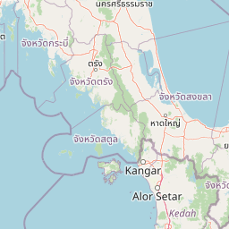
Understand where Tarutao National Park sits in Thailand through a broader geographic reading of the surrounding landscape, nearby location context, and its mapped position within the national park landscape.

How Tarutao National Park fits into Thailand

Thailand is a Southeast Asian nation formerly called Siam, located in mainland Southeast Asia. It operates as a unitary parliamentary constitutional monarchy under King Vajiralongkorn. The country borders Myanmar, Laos, Cambodia, and Malaysia, with maritime boundaries involving Vietnam, Indonesia, and India. Thailand has a population of nearly 66 million and covers approximately 513,120 km². Historically, the Sukhothai Kingdom marks the beginning of Thai history, followed by the powerful Ayutthaya Kingdom.

Wider geography shaping Tarutao National Park in Thailand

Thailand occupies mainland Southeast Asia with borders to Myanmar (west/northwest), Laos (east/northeast), Cambodia (southeast), and Malaysia (south). The country has coastline along the Gulf of Thailand to the southeast and the Andaman Sea to the southwest. The territory covers approximately 513,120 km².

Map view of Tarutao National Park

Use this park location map to pinpoint Tarutao National Park in Thailand, understand its exact geographic position, and read its mapped placement within the surrounding landscape more clearly.

Pigeon | © OpenStreetMap contributors

Location context for Tarutao National Park

Satun Province
Park atlas

Compare the diverse marine and island protected landscapes across the Strait of Malacca region.

Discover Marine National Parks and Protected Islands Near Tarutao National Park
Explore other national parks and protected areas near Tarutao National Park, including nearby marine zones and island ecosystems spanning the Strait of Malacca region. Compare diverse protected landscapes, trace regional conservation efforts, and discover new park geography to enhance your atlas-style understanding of Southeast Asia's marine environments.
National parkThailand

Mu Ko Phetra National Park: Thailand National Park Mapped Geography and Protected Landscape

Explore its mapped boundaries and regional atlas context.

Mu Ko Phetra National Park stands as a distinct protected area within Thailand, offering insights into its unique geographic setting. This detailed entry focuses on the park's mapped boundaries, its protected landscape characteristics, and its regional geography. Users can explore its placement within Thailand for a comprehensive understanding of its atlas significance and natural context.

Area
494 km²
Established
1984
IUCN
II
Visitors
129.9K annual
Stylized illustration of a forested area featuring a waterfall, large leaves, and a winding path
National parkSatun Province

Thale Ban National Park: Mapped Protected Landscape and Unique Wetland Ecosystem in Satun Province

Explore karst and granite mountains, natural lake geography, and diverse biodiversity.

Thale Ban National Park offers a fascinating study in protected landscape geography, centered around a rare natural lake formed by geological damming. This national park in Satun Province, Thailand, showcases a striking contrast between ancient limestone karst formations and younger granite mountains, contributing to its unique biodiversity and ecosystems. Its position near the Malaysian border highlights its role in regional conservation, making it a key site for understanding mapped terrain and protected natural areas.

Area
196 km²
Established
1980
IUCN
II
Visitors
12K annual
National parkTrang Province

Hat Chao Mai National Park: National Park Protected Landscape and Geographic Context

Explore Trang Province's mapped protected areas and natural terrain.

Hat Chao Mai National Park serves as a focal point for understanding protected lands in Trang Province, Thailand. This entry offers insights into the park's specific geographic attributes and its designation as a national park. Users can explore the mapped boundaries and the surrounding regional geography, gaining a clear picture of this protected landscape within the MoriAtlas geographic framework. Understanding Hat Chao Mai National Park provides essential context for regional park exploration and mapped conservation areas.

Area
231 km²
Established
1981
IUCN
II
Visitors
83K annual
National parkSongkhla Province

Khao Nam Khang National Park: National Park, Mapped Boundaries, and Regional Geography

Explore protected landscape identity and atlas context.

Gain detailed insights into Khao Nam Khang National Park, a key protected area situated within Songkhla Province. This national park serves as a critical reference point for understanding regional geography, its specific mapped boundaries, and its role as a conservation landscape. Discover its unique geographic context, vital for comprehensive atlas exploration of Thailand's natural heritage.

Area
212 km²
Established
1990
IUCN
II
Visitors
1.8K annual
National parkThailand

Mu Ko Lanta National Park: Protected National Park and Mapped Landscape in Thailand

Explore its boundaries within Thailand's regional geography.

Mu Ko Lanta National Park is a significant protected area within Thailand, defined by its national park status and distinct geographic features. This page facilitates structured discovery of its mapped landscape and the regional context it occupies. Users can explore its protected-area identity and understand how it fits into the broader atlas of natural landscapes in Southeast Asia, emphasizing geographic specificity and atlas-driven insights.

Area
134 km²
Established
1990
IUCN
II
Visitors
217.4K annual
National parkThailand

Khao Pu, Khao Ya National Park: Explore Protected Boundaries and Thailand Geography

A key national park for understanding regional landscape context.

Khao Pu, Khao Ya National Park stands as a vital protected area in Thailand, offering rich geographic details for atlas exploration. This page details its specific mapped boundaries and its identity as a national park, providing essential context for understanding natural landscapes within Southeast Asia. Users can gain insights into its regional significance and its contribution to the country's protected land network.

Area
694 km²
Established
1982
IUCN
II
Visitors
167.3K annual
National parkMalaysia

Penang National Park: Exploring Malaysia's National Park Atlas and Protected Landscapes

Understand the mapped geography and protected terrain of Penang National Park.

Penang National Park represents a crucial element within Malaysia's network of protected areas. This page offers detailed information for atlas-driven exploration, focusing on the park's specific geography, its mapped boundaries, and its contribution to the regional landscape. Gain a structured understanding of Penang National Park's identity as a protected national park, providing essential context for geographic discovery.

Area
12.13 km²
Established
2003
IUCN
II
Relief
Mixed relief
National parkKrabi Province

Hat Noppharat Thara, Mu Ko Phi Phi National Park: Protected Landscape and Geographic Identity

Explore mapped terrain and protected natural areas in Krabi Province.

Hat Noppharat Thara, Mu Ko Phi Phi National Park stands as a distinct protected natural landscape, offering a unique geographic perspective within Krabi Province. This page delves into its role as a national park, highlighting its mapped boundaries and contribution to the regional atlas. Users can explore the park's specific natural terrain and understand its significance as a conservation area, providing a foundation for broader geographic discovery.

Area
388 km²
Established
1983
IUCN
II
Visitors
1.1M annual

Common questions about visiting, size, designation, and location context for Tarutao National Park

Tarutao National Park FAQs for park facts, access, geography, and protected area context
Find quick answers about Tarutao National Park, including protected-area facts, park geography, trail and visitor context, and how the park fits into its surrounding country and regional landscape.
MoriAtlas Explorer

Continue Your Protected Areas Search Across the Global Atlas

Deepen your exploration by continuing the structured search for national parks and protected areas worldwide. Utilize the comprehensive filtering capabilities to compare different conservation landscapes and refine your understanding of global park geography. Discover more about the distribution and characteristics of protected natural areas.

Global natural geography
