Why Wandoo National Park stands out
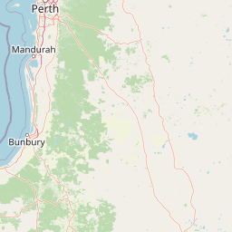
Wandoo National Park is best known for its protection of remnant wandoo woodland ecosystems in Western Australia's Wheatbelt region. The park preserves critical habitat for black-cockatoos and other endemic bird species in a landscape where native vegetation has been extensively cleared for agriculture. Its location relatively close to Perth makes it accessible for day visits, while the wandoo (Eucalyptus wandoo) woodlands themselves represent a distinctive component of the Southwest Australia Floristic Region, one of the world's biodiversity hotspots.
Wandoo National Park history and protected-area timeline
Wandoo National Park was officially designated as a national park in 2004, making it a relatively recent addition to Western Australia's protected area network. The establishment of the park reflected growing recognition of the importance of protecting remnant vegetation in the Wheatbelt region, where agricultural development had cleared the majority of native woodland and forest. The creation of the park was part of broader efforts by the Western Australian government to improve conservation outcomes in the Southwest Australia Floristic Region, an area of exceptional biodiversity that had suffered significant habitat loss. The park is managed by the Department of Parks and Wildlife, which oversees visitor facilities and conservation management within the protected area.
Wandoo National Park landscape and geographic character
Wandoo National Park protects characteristic Wheatbelt terrain dominated by wandoo woodland, a distinctive ecosystem of the southwest Australian interior. The landscape features gently undulating terrain typical of the Swanland Plain, with the wandoo (Eucalyptus wandoo) forming the primary tree species across much of the park. These woodlands create a park-like landscape with open canopy allowing sunlight to reach the understory, supporting diverse ground-layer vegetation. The park's position in the Wheatbelt places it within a landscape that has been extensively cleared for agriculture, making the preserved remnant vegetation within the park boundaries particularly valuable as reference ecosystems and habitat corridors.
Wandoo National Park ecosystems, habitats, and plant life
The park protects important examples of the Southwest Australia Floristic Region's unique plant communities. Wandoo woodlands support a diverse understory of shrubs and groundcover species typical of the region, many of which are endemic to southwest Australia. The park's position within a biodiversity hotspot means even relatively small areas of intact vegetation hold significant conservation value, as they provide habitat for species that have lost much of their original range to clearing. The woodland structure provides both canopy and hollow resources for fauna, while the understory supports insects and other invertebrates that form the base of the food chain.
Wandoo National Park wildlife and species highlights
Wandoo National Park provides habitat for several notable bird species, including populations of black-cockatoos that depend on woodlands in the Wheatbelt region. These large parrots, which include species such as the Carnaby's black-cockatoo and Baudin's black-cockatoo, rely on wandoo woodlands for nesting and feeding. The park's remnant vegetation also supports other bird species typical of southwest Australian woodlands, as well as mammals, reptiles, and invertebrates adapted to this ecosystem. The protection of woodland habitat in the Wheatbelt is particularly important given the extensive clearing that has occurred in the surrounding agricultural landscape.
Wandoo National Park conservation status and protection priorities
The conservation significance of Wandoo National Park stems from its role in protecting remnant vegetation in one of Australia's most heavily cleared regions. The Wheatbelt of Western Australia has lost the majority of its original native vegetation to agriculture, making the remaining protected areas critically important for biodiversity conservation. The park contributes to the protection of the Southwest Australia Floristic Region, which supports exceptional plant diversity with high levels of endemism. By preserving wandoo woodland communities, the park helps maintain habitat for species that have declined due to habitat loss in the surrounding farmland, including several bird species that are now considered threatened.
Top sights and standout views in Wandoo National Park
The park offers visitors the opportunity to experience remnant wandoo woodland in a landscape where such vegetation has become increasingly rare. Black-cockatoo populations draw birdwatching interest, while the park's relative proximity to Perth makes it accessible for day trips. The woodland landscape provides a contrasting experience to the more famous southwestern Australian forests found in national parks farther from the capital. The park represents the ecological character of the Wheatbelt, a region otherwise dominated by agricultural land use.
Best time to visit Wandoo National Park
The best time to visit Wandoo National Park is during the cooler months of autumn and spring, when temperatures are comfortable for outdoor exploration and the landscape remains accessible. Western Australia's Mediterranean climate means summer conditions in the Wheatbelt can be hot and dry, potentially limiting outdoor activity. Spring brings wildflower displays in the understory, adding visual interest to woodland walks. Visitors planning trips should check current conditions and any park alerts before traveling, as fire risk may affect access during the warmer months.