

Mori Atlas logo
Marine protected areaWilsons Promontory Marine National Park

Discover the mapped marine protected area surrounding Victoria's southernmost coastal terrain.

Wilsons Promontory Marine National Park: Protected Landscape & Marine Atlas Explorer

Wilsons Promontory Marine National Park represents a significant marine protected area encompassing 15,500 hectares of coastal waters and island ecosystems off the Gippsland region of Victoria, Australia. This park safeguards the vital transition zone where Bass Strait meets the Southern Ocean, protecting offshore island groups like the Glennie and Anser islands. Its landscape is characterized by dramatic rocky shores, sheltered bays, and the dynamic marine terrain surrounding these unique coastal features, offering a rich subject for map-based geographic discovery and atlas exploration.

Marine protected areaVictoria marine parksBass Strait islandsCoastal national parksSouthern Ocean marine environmentsOffshore islands

Wilsons Promontory Marine National Park

Marine protected area

Park overview

Structured park overview, official facts, and landscape profile for Wilsons Promontory Marine National Park

Wilsons Promontory Marine National Park park facts, protected area profile, and essential visitor context
Review the core facts for Wilsons Promontory Marine National Park, including designation, size, terrain, visitor scale, habitats, and operating context in one park-focused overview.

About Wilsons Promontory Marine National Park

Wilsons Promontory Marine National Park represents Victoria's commitment to protecting its southern coastal marine environments. The park occupies a strategically important position at the boundary between the temperate waters of Bass Strait and the more exposed conditions of the Southern Ocean. This geographic setting creates a marine environment of considerable ecological complexity, with the park protecting waters around the southern tip of Wilsons Promontory, one of Victoria's most prominent coastal landforms. The park's boundaries encompass the Glennie and Anser offshore island groups, extending from Norman Bay near Tidal River in the western portion of the promontory around to Cape Wellington in the east. This comprehensive marine protection zone surrounds islands that are recognized as part of the Wilsons Promontory Islands Important Bird Area, highlighting the interconnected terrestrial and marine ecological values of the region. The marine park works in conjunction with the adjacent Wilsons Promontory National Park to provide a holistic conservation framework that protects both the terrestrial and marine components of this distinctive coastal landscape. Wilsons Promontory Marine National Park also connects with a broader network of marine protected areas in the region, including Wilsons Promontory Marine Park to the north covering the ocean-facing coastline of the northern promontory section, and the Corner Inlet system of marine protected areas to the northeast.

Quick facts and research context for Wilsons Promontory Marine National Park

Wilsons Promontory Marine National Park covers 15,500 hectares (38,000 acres) of coastal and offshore waters in South Gippsland, Victoria. Established in 2003, it protects the marine environment around the southern tip of Wilsons Promontory, including the Glennie and Anser island groups. The park extends from Norman Bay westward to Cape Wellington eastward, encompassing diverse coastal and island marine habitats. The park is adjacent to Wilsons Promontory National Park and connects with other marine protected areas including Corner Inlet Marine National Park to the northeast and Wilsons Promontory Marine Park to the north. The surrounding waters are part of the Wilsons Promontory Islands Important Bird Area, recognizing the ecological significance of the region's islands for seabird populations.

Park context

Deeper park guide and search-rich context for Wilsons Promontory Marine National Park

Wilsons Promontory Marine National Park history, landscape, wildlife, and travel context
Explore Wilsons Promontory Marine National Park through its history, landscape character, ecosystems, wildlife, conservation priorities, cultural context, and seasonal travel timing in a structured park guide built for atlas discovery and search intent.

Why Wilsons Promontory Marine National Park stands out

Wilsons Promontory Marine National Park is best known for its diverse marine environments that transition between Bass Strait and the Southern Ocean. The park protects the island-studded waters around the Glennie and Anser island groups, which serve as critical habitat for seabirds and marine wildlife. The marine park encompasses dramatic coastal scenery where rocky headlands, sheltered bays, and offshore islands create a complex marine landscape. The protected waters support ecosystems that are significant for Victoria's coastal marine biodiversity, with the park serving as a marine extension of the renowned Wilsons Promontory National Park that adjoins it to the north.

Wilsons Promontory Marine National Park history and protected-area timeline

Wilsons Promontory Marine National Park was established in 2003 as part of Victoria's marine protected area network expansion. The creation of the park reflected a growing recognition of the ecological importance of Victoria's coastal and offshore marine environments, particularly in regions where complex coastlines and island groups create diverse habitat conditions. The establishment of the marine national park built upon the long-established protection of the adjacent Wilsons Promontory National Park, which has protected the terrestrial promontory since the early twentieth century. The marine park designation added comprehensive ocean and island protection to the existing terrestrial conservation framework, recognizing that effective environmental protection requires safeguarding both land and sea. The park is governed by Parks Victoria, the agency responsible for managing Victoria's protected areas, and operates under IUCN category II designation as a national park.

Wilsons Promontory Marine National Park landscape and geographic character

The landscape of Wilsons Promontory Marine National Park is defined by its position at the southernmost point of the Victorian mainland, where the coast transitions from the sheltered waters of Bass Strait to the more dynamic conditions of the Southern Ocean. The park encompasses a varied marine environment including rocky coastal shores, sheltered bays such as Norman Bay, exposed headlands around Cape Wellington, and the offshore waters surrounding the Glennie and Anser island groups. The islands within the park feature characteristic southern Australian coastal terrain with exposed granite formations, coastal heath vegetation, and dramatic cliff faces that drop into the surrounding waters. The underwater landscape includes reef systems, sandy seafloor, and the deeper waters of the open coast, creating a complex marine terrain that supports diverse ecological communities. The relationship between the marine park and the terrestrial Wilsons Promontory National Park creates a visually coherent landscape where the promontory's forested slopes and granite peaks rise from waters that are now protected within the marine national park.

Wilsons Promontory Marine National Park ecosystems, habitats, and plant life

The marine environment of Wilsons Promontory Marine National Park supports a range of habitats characteristic of Victoria's southern coast. The park protects waters where temperate marine species from Bass Strait interact with species more typical of the Southern Ocean, creating a zone of ecological transition. The island groups within the park, particularly the Glennie and Anser islands, provide important terrestrial habitat that influences the surrounding marine environment through processes such as nutrient input and seabird activity. The waters around these islands support reef communities, planktonic ecosystems, and the broader food webs that sustain marine biodiversity in this region. The marine park forms part of a connected conservation landscape that includes multiple adjacent marine protected areas, allowing for the protection of ecological processes that span across coastal and offshore zones.

Wilsons Promontory Marine National Park wildlife and species highlights

Wilsons Promontory Marine National Park provides habitat for marine wildlife in the waters off Victoria's southern coast. The islands within and adjacent to the park, particularly those forming part of the Wilsons Promontory Islands Important Bird Area, support significant seabird populations including various species that nest on the rocky island habitats. The marine waters provide foraging areas for seabirds and support the broader marine food webs that sustain fish, invertebrates, and other marine organisms. The transition between Bass Strait and Southern Ocean waters creates conditions that support both temperate and subantarctic marine species, contributing to the biodiversity significance of the protected waters. The complex marine landscape including islands, reefs, and varying depths creates diverse habitat conditions that support different wildlife communities throughout the park.

Wilsons Promontory Marine National Park conservation status and protection priorities

Wilsons Promontory Marine National Park plays an important role in Victoria's marine conservation network. The park is designated under IUCN category II as a national park, reflecting its significance as a protected area of national importance. The marine park protects waters around islands that are recognized as part of the Wilsons Promontory Islands Important Bird Area, highlighting the interconnected nature of terrestrial and marine conservation values in this region. The establishment of the park in 2003 represented a significant addition to Victoria's marine protected area estate, helping to complete the conservation picture around the Wilsons Promontory peninsula. The park works in conjunction with multiple adjacent marine protected areas including Wilsons Promontory Marine Park to the north and the Corner Inlet system of marine national parks and marine coastal parks to the northeast, creating a comprehensive regional conservation framework. This network approach supports ecological connectivity and protects the diverse marine environments found along Victoria's southern coast.

Wilsons Promontory Marine National Park cultural meaning and human context

Wilsons Promontory holds significance in the context of Victoria's coastal history and European settlement patterns. The promontory was an early focus of European exploration and settlement in the Gippsland region, with the area's strategic coastal position recognized from the earliest days of colonial Victoria. The marine park extends protection to waters that have been used by maritime activities historically, including fishing and coastal shipping that have long characterized the Bass Strait and southern Victorian coast. Wilsons Promontory National Park, which adjoins the marine park, has been a significant conservation area since the early twentieth century, with the addition of marine protection in 2003 reflecting evolving understanding of the importance of marine ecosystem conservation.

Top sights and standout views in Wilsons Promontory Marine National Park

The Wilsons Promontory Marine National Park protects a significant portion of Victoria's southern coastal marine environment, spanning 15,500 hectares from Norman Bay to Cape Wellington and encompassing the Glennie and Anser island groups. The marine park forms an essential component of a larger connected conservation landscape that includes Wilsons Promontory National Park, Wilsons Promontory Marine Park, and multiple other marine protected areas in the Corner Inlet region. The park's designation as IUCN category II recognizes its national significance as a marine protected area. The surrounding islands are part of an Important Bird Area, underscoring the ecological importance of this coastal and island landscape.

Best time to visit Wilsons Promontory Marine National Park

The waters of Wilsons Promontory Marine National Park can be experienced throughout the year, with the marine environment maintaining its character across seasons. The summer months typically bring more settled weather conditions favorable for boat-based activities and coastal exploration around the park. The transitional seasons of spring and autumn offer opportunities to experience the changing conditions of this southern coastal environment. The park is best accessed from the Tidal River area, which serves as the main gateway to the Wilsons Promontory region and provides links to the adjacent national park.
Park location guide

Geography guide, regional context, and park location map for Wilsons Promontory Marine National Park

Wilsons Promontory Marine National Park park geography, regions, and map view in Australia
Understand where Wilsons Promontory Marine National Park sits in Australia through a broader geographic reading of the surrounding landscape, nearby location context, and its mapped position within the national park landscape.

How Wilsons Promontory Marine National Park fits into Australia

Australia is a constitutional monarchy and federal parliamentary democracy comprising six states and ten territories. With a population of nearly 28 million, it is one of the world's most urbanised countries, with most people concentrated on the eastern seaboard. The country has a high Human Development Index and is known for its cultural diversity, ancient Aboriginal heritage, and unique wildlife.

Wider geography shaping Wilsons Promontory Marine National Park in Australia

Australia occupies the entire Australian continent, the island of Tasmania, and numerous smaller islands. It is the world's flattest and driest inhabited continent, featuring vast deserts in the interior (the Outback), tropical rainforests along the eastern coast, and a coastline bordering the Indian and Pacific Oceans.

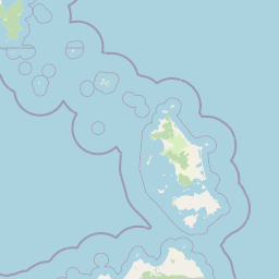
Map view of Wilsons Promontory Marine National Park

Use this park location map to pinpoint Wilsons Promontory Marine National Park in Australia, understand its exact geographic position, and read its mapped placement within the surrounding landscape more clearly.

Pigeon | © OpenStreetMap contributors
Park atlas

Discover adjacent protected landscapes: compare other marine and terrestrial parks in Victoria's Gippsland region.

Explore Other Parks Near Wilsons Promontory Marine National Park, Victoria: Coastal & Marine Protected Areas
After exploring Wilsons Promontory Marine National Park, you can browse other significant marine protected areas and terrestrial national parks located nearby across Victoria's diverse Gippsland region. This allows for direct comparison of their unique coastal and island landscapes, providing broader insight into regional conservation efforts and geographic features along Australia's southern coast.
National park

Wilsons Promontory National Park: Southernmost Australian National Park with Granite Landscapes and Rainforests

Mapped geography of a dramatic coastal and wilderness park.

Wilsons Promontory National Park, situated at Australia's southern mainland extremity, represents a significant protected landscape. The park's geography is defined by ancient granite formations, creating dramatic peaks and headlands that meet the Bass Strait. Within its boundaries, diverse ecosystems flourish, including rare temperate rainforests and heathy woodlands. This page provides detailed geographic context and atlas-style discovery for this iconic protected area.

Area
505 km²
Established
1898
IUCN
II
Relief
Mixed relief
Marine protected area

Corner Inlet Marine National Park: Australian Protected Marine Landscape Atlas

Explore tidal wetlands and marine protected area geography.

Corner Inlet Marine National Park is a designated marine protected area in South Gippsland, Victoria, renowned for its ecological importance as part of a Ramsar-listed wetland. This park encompasses the waters and extensive intertidal zones of Corner Inlet, featuring vital seagrass beds and tidal marshes. Its protected status highlights its significance within Australia's marine park network, offering a clear example of coastal inlet conservation and regional landscape context for map-based exploration.

Area
15.5 km²
Established
2002
IUCN
II
Relief
Lowland
National park

Bunurong Marine National Park: Protected Marine Area with Diverse Reefs and Coastal Landscapes

Explore unique rock formations and rich marine biodiversity off Victoria's coast.

Bunurong Marine National Park in Victoria, Australia, is a designated national park safeguarding remarkable marine ecosystems. Its protected geography features striking coastal features like Eagles Nest and a wealth of subtidal and intertidal rocky reefs teeming with life. This area is renowned for its high marine invertebrate diversity, significant fossil sites such as the Cape Paterson Claw discovery, and provides exceptional opportunities for mapped landscape exploration of its underwater terrains.

Area
21 km²
Established
2002
IUCN
II
Visitors
250K annual
National park

Tarra-Bulga National Park: Ancient Mountain Ash Forest Protected Landscape in Victoria

Explore mapped fern gullies and temperate rainforest ecosystems.

Tarra-Bulga National Park is a protected national park in Victoria, Australia, renowned for its spectacular old-growth mountain ash forests and lush fern gullies. This significant fragment of temperate rainforest offers a unique window into the region's natural heritage and geographic past. Discover the mapped landscape character, including towering trees and vibrant undergrowth, making it a key destination for protected-area exploration.

Area
15.22 km²
Established
1986
IUCN
II
Visitors
80K annual
National park

Morwell National Park: Protected Landscape Diversity in Victoria's Strzelecki Ranges

Explore the mapped terrain and unique forest ecosystems.

Morwell National Park, an Australian national park in the Strzelecki Ranges, is celebrated for its extraordinary plant and animal diversity within a concentrated area. The park preserves critical wet sclerophyll forests and delicate temperate rainforest pockets within deep gullies, offering a distinct landscape character. Its establishment reflects a significant community-driven conservation effort, making it a valuable site for understanding regional protected-area geography and landscape richness.

Area
5.65 km²
Established
1966
IUCN
III
Relief
Highland
National parkTasmania

Kent Group National Park: Protected Landscape in Tasmania, Australia

National Park mapping and geographic context.

Kent Group National Park is an essential protected natural area situated within Tasmania, Australia. This national park offers a clear example of a mapped protected landscape, contributing to the understanding of regional geography and conservation efforts in Tasmania. MoriAtlas provides structured data to explore its boundaries and geographic significance, aiding in a comprehensive atlas-style discovery of its protected natural identity.

Area
312.83 km²
Established
1971
IUCN
II
Scope
Mixed
Marine protected area

Ninety Mile Beach Marine National Park: Victoria's Coastal Marine Protected Area

Mapped boundaries and temperate marine landscape context.

Ninety Mile Beach Marine National Park represents a significant commitment to marine conservation along the eastern Victorian coast. This protected area safeguards the underwater ecosystems adjacent to the celebrated Ninety Mile Beach, a nearly 100-kilometer stretch of continuous sandy shoreline. Its establishment in 2002 preserves the marine biodiversity and coastal landscape character of this region, forming an integral part of Victoria's network of protected coastal environments and offering a distinct view of Australia's marine geography.

Area
27.5 km²
Established
2002
IUCN
II
Scope
Marine
National park

French Island National Park: Protected Island National Park with Coastal Wetland Habitats

Explore mapped boundaries and diverse terrain of this unique park.

French Island National Park preserves a vital island ecosystem in Victoria, Australia, featuring extensive mangrove forests, salt marshes, and open woodland. As one of Australia's most accessible island national parks, it offers a distinctive wilderness experience primarily reached by boat, showcasing coastal conservation and unique wetland habitats. The park's geography is defined by its low-lying terrain and tidal influences, creating a rich environment for mapped landscape exploration.

Area
111 km²
Established
1998
IUCN
II
Relief
Lowland

Common questions about visiting, size, designation, and location context for Wilsons Promontory Marine National Park

Wilsons Promontory Marine National Park FAQs for park facts, access, geography, and protected area context
Find quick answers about Wilsons Promontory Marine National Park, including protected-area facts, park geography, trail and visitor context, and how the park fits into its surrounding country and regional landscape.
MoriAtlas Explorer

Continue Your Protected Areas Search Across the Global Atlas

Deepen your exploration by continuing the structured search for national parks and protected areas worldwide. Utilize the comprehensive filtering capabilities to compare different conservation landscapes and refine your understanding of global park geography. Discover more about the distribution and characteristics of protected natural areas.

Global natural geography