Mori Atlas logo
National parkAltınbeşik Cave National Park

Discover the unique geology and mapped boundaries of this Antalya Province national park.

Altınbeşik Cave National Park: Explore Turkey's Premier Subterranean Lake and Karst Landscape

(Altınbeşik Mağarası Milli Parkı)

Altınbeşik Cave National Park in Antalya Province, Turkey, protects a spectacular karst landscape centered around one of the country's most significant geological wonders. This national park showcases Altınbeşik Cave, renowned for its vast subterranean lake—the largest in Turkey—and impressive travertine formations. Explore the mapped boundaries and discover how this unique protected area fits into the broader regional geography of the Taurus Mountains.

Cave SystemsKarst LandscapeSubterranean LakesGeological FormationsTravertine FormationsTaurus Mountains
Watercolor depiction of a cave entrance with turquoise water, three small boats on the shore, and surrounding greenery

Altınbeşik Cave National Park

National park

Park overview

Structured park overview, official facts, and landscape profile for Altınbeşik Cave National Park

Altınbeşik Cave National Park park facts, protected area profile, and essential visitor context
Review the core facts for Altınbeşik Cave National Park, including designation, size, terrain, visitor scale, habitats, and operating context in one park-focused overview.

About Altınbeşik Cave National Park

Altınbeşik Cave National Park protects a remarkable karst cave system in the mountainous interior of Antalya Province, where the Taurus Mountains create a landscape of deep valleys, steep cliffs, and complex geological formations. The park was established in 1994 to safeguard both the cave itself and the surrounding karst environment that feeds its hydrological system. The cave's significance extends far beyond its immediate physical dimensions; it serves as the outlet for one of the world's most extensive karst aquifer systems, collecting groundwater that has traveled through more than 100 kilometers of underground passages from multiple catchment basins. The underground lake within the cave is Turkey's largest, and its travertine formations—including the spectacular 44-meter cascade—are among the most impressive in any European cave. The surrounding landscape features the characteristic karst topography of the Taurus Mountains, with limestone formations, sinkholes, and underground drainage systems creating a complex hydrological network that feeds the cave system. Pine forests clothe the slopes above the cave, framing the dramatic valley setting where Altınbeşik Cave emerges from the mountainside.

Quick facts and research context for Altınbeşik Cave National Park

Altınbeşik Cave National Park covers an area of approximately 1,147 hectares in the Taurus Mountains of southwestern Turkey. The cave system is Turkey's premier subterranean lake formation, with its underground lake reaching 15 meters in depth. The protected area sits at the outlet of an extensive karst aquifer that drains water from the Kızılova, Kambos, and Söbüce basins through a network of passages extending over 100 kilometers in straight-line distance. The cave contains impressive travertine deposits, with the largest single formation reaching 44 meters in height. The cave interior maintains a constant temperature between 16-18°C year-round with high humidity. The area features characteristic karst topography draped with pine forest, creating a distinctive landscape where the subterranean cave system emerges from the steep Manavgat valley walls.

Park context

Deeper park guide and search-rich context for Altınbeşik Cave National Park

Altınbeşik Cave National Park history, landscape, wildlife, and travel context
Explore Altınbeşik Cave National Park through its history, landscape character, ecosystems, wildlife, conservation priorities, cultural context, and seasonal travel timing in a structured park guide built for atlas discovery and search intent.

Why Altınbeşik Cave National Park stands out

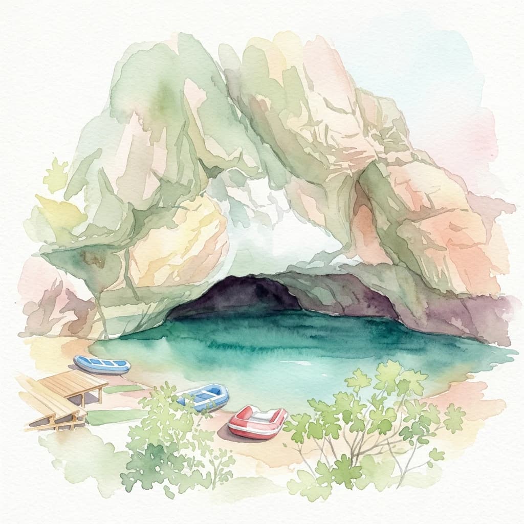
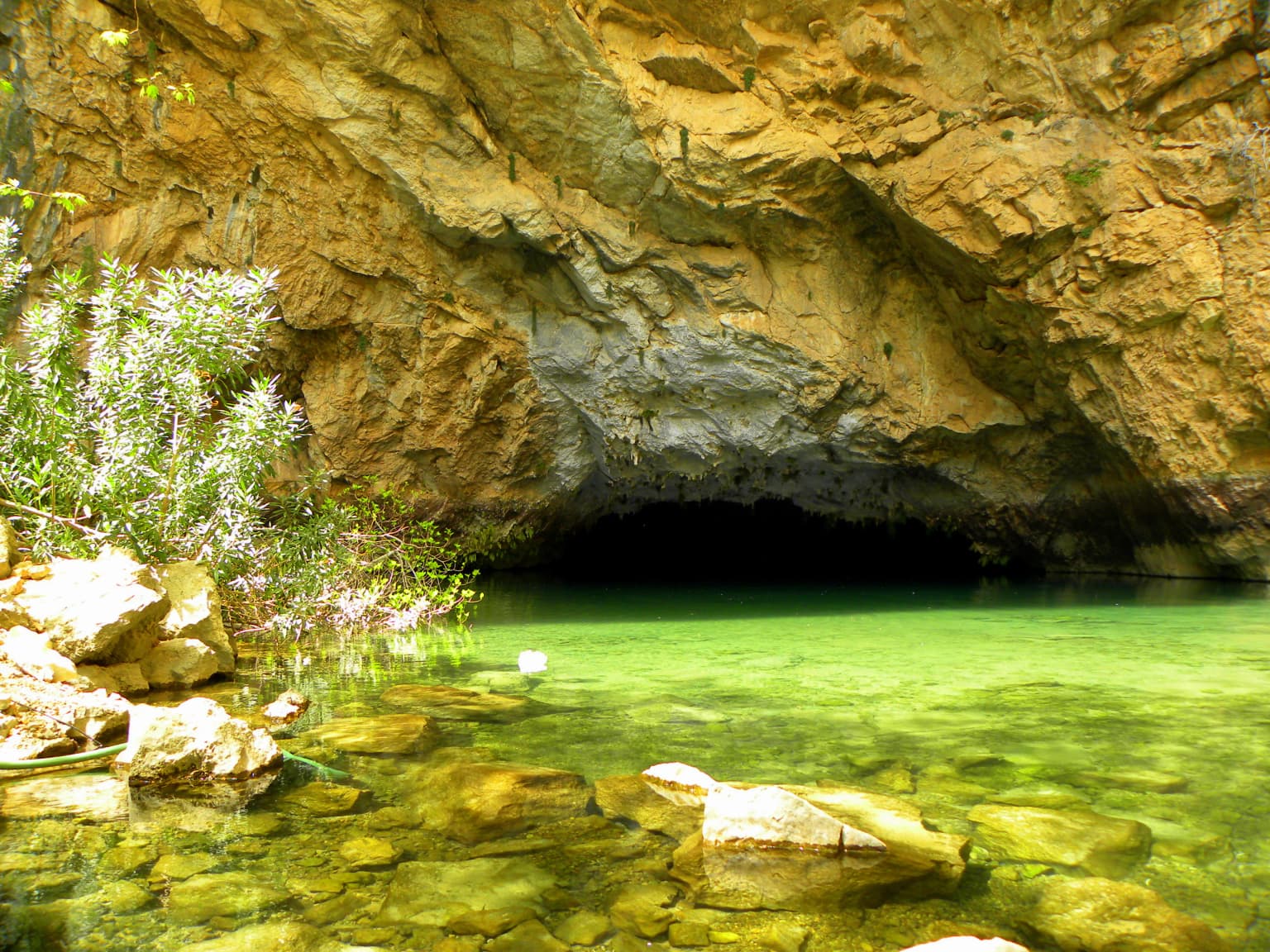
Altınbeşik Cave is renowned as Turkey's largest subterranean lake cave and one of Europe's most significant cave systems. The underground lake, reaching depths of 15 meters, dominates the cave's character and makes it unique among Turkish caves. The cave contains extraordinary travertine formations including what is described as the largest travertine in Turkey, a 44-meter-high mineral deposit that ranks among the tallest in any cave system. The natural rock bridge spanning the central passage adds to the geological significance. Beyond its speleological importance, the cave represents the discharge point of an enormous karst aquifer system stretching over 100 kilometers, making it one of the longest and most complex underground water systems in the world.

Cave entrance with clear green water, rocky formations, and vegetation
Entrance to Altınbeşik Cave National Park with clear green water and rocky surroundings

Altınbeşik Cave National Park history and protected-area timeline

Altınbeşik Cave National Park was formally established on August 31, 1994, by the Turkish Ministry of Forest and Water Management, designating the cave and its surrounding area as a protected national park. The establishment reflected growing recognition of the cave's exceptional geological and hydrological significance within Turkey's protected areas network. Prior to national park status, the cave had been known to speleologists and researchers for its unusual规模 and underwater lake, but the 1994 designation brought formal protection to the site and recognition of its broader watershed importance. Scientific exploration and mapping of the extensive cave system has continued since the park's establishment, with researchers progressively documenting the complex network of passages, the extent of the underwater lake, and the connections to the broader karst aquifer. The cave remains an active subject of geological and hydrological research, with ongoing studies aimed at fully understanding the extent of the underground system and its relationship to the regional groundwater regime.

Altınbeşik Cave National Park landscape and geographic character

The landscape of Altınbeşik Cave National Park is defined by the dramatic topography of the western Taurus Mountains, where the Manavgat River has carved a deep, steep-sided valley. The cave system is positioned on the western slope of this valley, emerging from the rock face at a significant elevation above the valley floor. The surrounding terrain displays classic karst topography with limestone outcrops, solution features, and the characteristic absence of surface drainage that marks karst terrain. The steep valley walls are forested with pine trees, creating a contrast between the dark green forest cover and the lighter limestone cliffs. The cave entrance itself opens dramatically from the valley wall, providing access to the underground lake and travertine formations within. Above the cave, the terrain rises toward Altınbeşik Peak, for which the cave is named, and the higher elevations feature the typical rocky, forested landscape of the Taurus Mountains. The combination of the deep valley, the forest-covered slopes, the karst terrain, and the subterranean cave system creates a landscape of significant visual and geological complexity.

Altınbeşik Cave National Park ecosystems, habitats, and plant life

The ecological character of Altınbeşik Cave National Park centers on its karst geology and the subterranean environment rather than surface biodiversity. The cave system itself is notable for the absence of significant animal communities within its passages, a characteristic of underwater lake caves with their limited food resources and stable but specialized conditions. The cave maintains a constant temperature of 16-18°C throughout the year with consistently high humidity, creating an environment that supports limited specialized organisms but not diverse communities. The surrounding surface environment features Mediterranean pine forest on the slopes above the valley, typical of the Taurus Mountain forest ecosystems. The karst landscape supports characteristic vegetation adapted to the limestone substrate and the semi-arid climate of the region. The hydrological significance of the site is profound, as the cave serves as the discharge point for an extensive underground aquifer system that drains water from a catchment area spanning more than 100 kilometers, connecting to Lake Beyşehir underground.

Altınbeşik Cave National Park wildlife and species highlights

The wildlife within Altınbeşik Cave itself is notably limited, as the cave's submerged nature and stable underground lake environment do not support diverse troglobitic or troglophilic communities. The cave's underwater lake, reaching 15 meters in depth, and the lack of organic input mean that significant animal populations have not been documented within the cave system. The surrounding surface environment of the national park supports the typical fauna of the Taurus Mountain pine forests, including various bird species, small mammals, and the occasional larger mammals that inhabit the forested slopes. However, the park's primary significance lies in its geological and hydrological features rather than as a habitat for notable wildlife populations. The karst landscape surrounding the cave provides some habitat for cave-dwelling species in smaller fissures and openings, but the main cave system itself does not harbor significant wildlife.

Altınbeşik Cave National Park conservation status and protection priorities

Altınbeşik Cave National Park represents an important conservation priority as Turkey's premier subterranean lake cave and one of Europe's most significant karst systems. The protected status established in 1994 guards both the cave's remarkable geological formations—including the largest travertine in Turkey and the natural rock bridge—and the integrity of the broader karst aquifer that feeds the underground lake. The cave's hydrological function as the discharge point for an aquifer system spanning over 100 kilometers adds regional conservation significance, as the underground water resources connect to Lake Beyşehir and support broader ecosystem functions. Conservation of the site requires protecting both the cave itself from physical disturbance and the surface catchments that contribute water to the underground system, recognizing that the karst aquifer's quality depends on land management across a large geographic area. The designation as a national park reflects Turkey's commitment to preserving its exceptional karst and speleological heritage.

Altınbeşik Cave National Park cultural meaning and human context

The Altınbeşik Cave holds cultural significance through its place in the landscape of the Taurus Mountains and its relationship to local communities in the Antalya Province. The cave takes its name from Altınbeşik Peak, located above the cave entrance, connecting the subterranean feature to the broader topographic identity of the region. The area around the cave has been part of the traditional land use patterns of the Taurus Mountains, with nearby villages such as Ürünlü maintaining connections to the landscape. The deep Manavgat valley and the karst terrain have shaped local settlement patterns and historical movement through the region. While the cave itself does not have extensive documented archaeological or historical use, its dramatic setting on the valley wall and its proximity to traditional routes through the mountains connect it to the broader cultural landscape of the Antalya hinterland.

Top sights and standout views in Altınbeşik Cave National Park

The defining highlights of Altınbeşik Cave National Park include Turkey's largest subterranean lake, reaching depths of 15 meters within passages extending 2,200 meters into the mountain. The cave contains extraordinary travertine formations, most notably a 44-meter-high cascade that ranks among the tallest such deposits in any European cave. The natural stone bridge spanning the central passage adds to the site's geological significance. The cave system represents one of the world's longest karst aquifers, collecting water from catchments over 100 kilometers away and discharging underground to Lake Beyşehir. The dramatic setting on the steep western slope of the Manavgat valley, with pine forest covering the surrounding slopes, creates a compelling landscape that frames the cave entrance.

Best time to visit Altınbeşik Cave National Park

Altınbeşik Cave National Park is accessible and suitable for visitation during the summer months and early autumn, when water levels in the cave system are at their lowest and the underground lake can be safely explored. The cave closes to visitors during winter and spring when precipitation increases and groundwater levels rise, flooding passages and making access unsafe. Summer and autumn visits offer the opportunity to experience the cave's underground lake and travertine formations with reliable access, while the surrounding surface areas of the national park can be explored year-round. The cave's stable internal temperature of 16-18°C makes the underground environment comfortable for exploration regardless of external seasonal conditions.

Park location guide

Geography guide, regional context, and park location map for Altınbeşik Cave National Park

Altınbeşik Cave National Park park geography, regions, and map view in Turkey
Understand where Altınbeşik Cave National Park sits in Turkey through a broader geographic reading of the surrounding landscape, nearby location context, and its mapped position within the national park landscape.

How Altınbeşik Cave National Park fits into Turkey

Turkey, officially the Republic of Türkiye, is a transcontinental country located mainly in Anatolia (West Asia) with a smaller portion in East Thrace (Southeast Europe). It borders the Black Sea to the north, several countries to the east and south, and the Aegean Sea and European countries to the west. The country has a population of over 86 million and operates as a secular, Muslim-majority presidential republic with Ankara as capital and Istanbul as its largest city.

Wider geography shaping Altınbeşik Cave National Park in Turkey

Turkey is a transcontinental country with the majority of its territory (about 97%) located in Anatolia (West Asia) and a smaller portion called East Thrace in Southeast Europe. It borders the Black Sea to the north, Georgia, Armenia, Azerbaijan, and Iran to the east, Iraq and Syria to the south, and the Mediterranean Sea to the southwest. To the west, Turkey borders the Aegean Sea, Greece, and Bulgaria. The terrain includes mountains, plateaus, and coastal plains, with the Taurus Mountains running along the southern coast.

Map view of Altınbeşik Cave National Park

Use this park location map to pinpoint Altınbeşik Cave National Park in Turkey, understand its exact geographic position, and read its mapped placement within the surrounding landscape more clearly.

Pigeon | © OpenStreetMap contributors

Location context for Altınbeşik Cave National Park

Antalya Provinceİbradı

Visual Atlas of Turkey's Largest Lake Cave and Protected Taurus Mountains Environment

Altınbeşik Cave National Park Photos: Explore Karst Landscapes and Subterranean Lake Scenery
Explore Altınbeşik Cave National Park photos to visually understand its dramatic karst topography, deep valley formations, and Turkey's unique subterranean lake system. Gain crucial insight into the park's protected landscapes, pine-forested slopes, geological features, and the distinct environment of its renowned cave habitat within the Taurus Mountains.

Cave entrance with clear green water, rocky formations, and vegetation

Boats docked near cave entrance with turquoise underground lake

Park atlas

Trace the regional spread of protected landscapes across Antalya Province and the Taurus Mountains, comparing diverse park geographies.

Explore National Parks and Protected Areas Near Altınbeşik Cave National Park in Antalya Province
After exploring Altınbeşik Cave National Park, continue your discovery by browsing other protected areas nearby in Turkey's Antalya Province. Compare varied park geographies, from further karst systems to coastal landscapes and mountain reserves, to understand the broader regional conservation context.
National parkTurkey

Derebucak Çamlık Caves National Park: Turkey's Protected Karst Caves and Landscape

Explore Konya Province's longest cave system and its unique geological context.

Derebucak Çamlık Caves National Park is a vital protected landscape in central Turkey, celebrated for its extensive karst topography and significant cave formations. This national park encompasses thirteen unique caves and sinkholes, with Balatini Cave holding the distinction of being Konya Province's longest. The park's rugged terrain, characterized by pine forests and the Balat Stream feeding its underground systems, offers a profound look into Turkey's geological heritage and the conservation of its unique subterranean environments. MoriAtlas helps you navigate this mapped protected area.

Area
11.47 km²
Established
2022
Watercolor painting of colorful rowboats on a lake with distant mountains
National parkKonya Province

Lake Beyşehir National Park: Protected Landscape Geography and Mapped Boundaries

Discover the geography and mapped context of this national park in Konya.

Lake Beyşehir National Park is a major protected area in Turkey's Central Anatolia region, celebrated for its immense freshwater lake and diverse wetland habitats. The park's identity is strongly tied to its mapped boundaries that protect critical ecosystems, islands, and surrounding forested terrain. This page provides a detailed look at the park's geographic setting within Konya Province, serving as a valuable resource for atlas-based discovery of its unique natural and cultural landscape.

Area
868.55 km²
Established
1993
Relief
Lowland
Climate
Temperate
Watercolor painting showing a lake, mountains, trees, and grassy shoreline
National parkIsparta Province

Lake Kovada National Park: Mapped Protected Landscape in Isparta Province

Discover the geography and lake ecosystem of this Turkish national park.

Lake Kovada National Park offers a detailed look at a protected natural area within Turkey's Isparta Province. This page provides insights into the park's protected landscape, focusing on the central freshwater lake and its surrounding montane terrain. Explore its geographic context, mapped boundaries, and status as a significant protected area within the Taurus Mountain region, ideal for atlas-based discovery of Anatolian natural environments.

Area
65.51 km²
Established
1970
Scope
Terrestrial
Water
Major water bodies
Watercolor illustration of green hills, pine trees, and distant mountains under a light sky
National parkIsparta Province

Kızıldağ National Park: Protected Taurus Mountain Landscape and Atlas Context

Mapped boundaries, alpine terrain, and unique cedar forests.

Kızıldağ National Park offers a detailed look into Turkey's protected natural heritage, specifically highlighting the dramatic mountainous terrain of the Taurus Ranges. This page provides atlas-level geographic information about its mapped boundaries, the significant Dedegöl Mountain, and the rare blue-leaf cedar forests unique to this region. Understand its role as a vital conservation area within Isparta Province and the broader Mediterranean mountain ecosystem.

Area
551.06 km²
Established
1969
Relief
Mountain
Scope
Terrestrial
Watercolor painting of a river flowing through green hills and mountains under a soft sky.
National parkMuğla Province

Saklıkent National Park: Explore Turkey's Deepest Gorge, Limestone Formations, and Protected Terrain

A remarkable national park showcasing dramatic canyon geography and karst landscapes.

Saklıkent National Park presents an extraordinary example of a protected landscape dominated by a deep limestone canyon in Muğla Province, Turkey. This national park invites exploration of its striking geological features, including towering cliffs and flowing karstic springs that form a spectacular gorge. Users engaging with Saklıkent National Park gain insight into the mapped boundaries of protected areas and the unique natural terrain sculpted by water over millennia, offering a rich geographic context for atlas discovery.

Area
16.43 km²
Established
1996
Visitors
200K annual
Relief
Mountain
Protected areaTurkey

Commander-in-Chief National Historic Park: Historic Battlefield Landscape in Turkey

Protected Area preserving pivotal geography and military history.

Commander-in-Chief National Historic Park is a designated protected area in Turkey, preserving the historic terrain of the decisive Battle of Dumlupınar. This site offers a unique glimpse into the geography and landscape that were instrumental in a key moment of the Turkish War of Independence. Explore the mapped context of this significant battlefield, understanding its role within the broader Anatolian geography and its importance as a preserved historic site.

Area
409.48 km²
Established
1981
Relief
Mixed relief
Climate
Temperate
National parkMuğla Province

Marmaris National Park: Mediterranean Forest Protected Landscape and Ancient Heritage

Discover its geography, mapped boundaries, and unique flora.

Marmaris National Park in Muğla Province offers a deep dive into a protected Mediterranean forest ecosystem and Carian history. Explore its rugged terrain, dramatic coastlines where pine forests meet the sea, and discover ancient sites like the Amos amphitheatre. This park is a key area for understanding regional geography, mapped natural landscapes, and the unique botanical diversity of Turkey's southwestern coast, supporting detailed atlas exploration.

Area
333.5 km²
Established
1996
Visitors
8.5M annual
Relief
Mixed relief
National parkTurkey

Aladağlar National Park: Turkey's Dramatic Alpine Protected Landscape

Rugged terrain and crimson peaks in the Anti-Taurus Mountains.

Delve into Aladağlar National Park, a significant protected area defined by its striking alpine environment within Turkey's Anti-Taurus range. This park is renowned for its rugged, high-altitude wilderness, characterized by dramatic granite peaks that display a unique crimson coloration, especially at sunset. Its landscape features steep valleys, alpine lakes formed from snowmelt, and challenging mountaineering opportunities. MoriAtlas offers detailed map context to appreciate the geographic distinctiveness and ecological importance of this elevated protected terrain.

Area
550.65 km²
Established
1995
Relief
Mountain
Climate
Alpine

Common questions about visiting, size, designation, and location context for Altınbeşik Cave National Park

Altınbeşik Cave National Park FAQs for park facts, access, geography, and protected area context
Find quick answers about Altınbeşik Cave National Park, including protected-area facts, park geography, trail and visitor context, and how the park fits into its surrounding country and regional landscape.
MoriAtlas Explorer

Continue Your Protected Areas Search Across the Global Atlas

Deepen your exploration by continuing the structured search for national parks and protected areas worldwide. Utilize the comprehensive filtering capabilities to compare different conservation landscapes and refine your understanding of global park geography. Discover more about the distribution and characteristics of protected natural areas.

Global natural geography