Mori Atlas logo
National parkBreheimen National Park

Explore Norway's protected mountain wilderness and its unique terrain within Innlandet county.

Breheimen National Park: A Mapped National Park of Glacial Landscapes and Alpine Terrain

(Breheimen nasjonalpark)

Breheimen National Park is a significant protected landscape in southern Norway, established to preserve the remarkable glacial terrain and diverse mountain ecosystems of the Breheimen range. Covering 1,671 square kilometers, this national park in Innlandet county showcases dramatic peaks, active glaciers, and a striking contrast between wet alpine environments and drier plateau regions. MoriAtlas provides detailed geographic context, allowing for exploration of the park's mapped boundaries and its role within Norway's broader protected areas network.

National ParksNorwayGlacial LandscapesMountain WildernessAlpine EnvironmentsInnlandet

Breheimen National Park

National park

Park overview

Structured park overview, official facts, and landscape profile for Breheimen National Park

Breheimen National Park park facts, protected area profile, and essential visitor context
Review the core facts for Breheimen National Park, including designation, size, terrain, visitor scale, habitats, and operating context in one park-focused overview.

About Breheimen National Park

Breheimen National Park represents one of Norway's newer protected areas, established in 2009 through Royal decree following an extended planning process that began with the government's Second National Park Plan in 1986. The park safeguards 1,671 square kilometres of the Breheimen mountain range, a landscape of exceptional geological and ecological significance that spans the transitional zone between eastern and western Norway. The name Breheimen—meaning 'Home of The Glaciers'—aptly captures the park's defining characteristic: a landscape where ice has been the primary architect of terrain, carving deep valleys, shaping dramatic peaks, and leaving behind active glacial systems that continue to evolve. The park straddles two counties, with portions in Skjåk Municipality and Lom Municipality in Innlandet, and Luster Municipality in Vestland, creating a cross-regional protected area that encompasses diverse administrative and ecological zones. The establishment of Breheimen prompted local municipalities, particularly Skjåk where most of the park lies, to reorient development planning toward nature-based tourism and environmental stewardship, recognizing the economic and cultural significance of protected landscape designation.

Quick facts and research context for Breheimen National Park

Breheimen National Park protects a dramatic mountain landscape in southern Norway spanning the Innlandet and Vestland counties. The 1,671 km² park was established in 2009 and encompasses the Breheimen mountain range, featuring some of Norway's most varied terrain including both the wettest and driest areas in the country. The landscape has been shaped by glacial processes, avalanches, and geological forces over hundreds of thousands of years. The park is notable for its ecological diversity, ranging from fertile transhumance-farmed valleys to alpine plateaus and active glacial formations. Nearby communities include Skjolden and Bismo, which serve as gateway settlements for visitors exploring this protected mountain wilderness.

Park context

Deeper park guide and search-rich context for Breheimen National Park

Breheimen National Park history, landscape, wildlife, and travel context
Explore Breheimen National Park through its history, landscape character, ecosystems, wildlife, conservation priorities, cultural context, and seasonal travel timing in a structured park guide built for atlas discovery and search intent.

Why Breheimen National Park stands out

Breheimen National Park is especially known for its extraordinary glacial landscapes and the dramatic mountain terrain of the Breheimen range. The park protects active glaciers and the surrounding peaks that have been carved by ice over millennia, creating a landscape of soaring ridgelines, glacial valleys, and exposed rock. The area's remarkable ecological diversity, spanning from lush pastoral valleys to barren alpine plateaus within a single protected area, makes it distinctive among Norway's national parks. Archaeological significance adds another dimension, with the 2011 discovery of a 300 AD men's coat from a melting glacier representing Norway's oldest known textile artifact. The park also preserves remnants of medieval sælehus shelters and ancient reindeer-hunting traps, providing tangible links to historical human use of these mountain environments.

Mountain lake landscape with turquoise water, snow-capped peaks, rocky terrain, and scattered clouds under a blue sky
Mountain lake view with snow-capped peaks in Breheimen National Park

Breheimen National Park history and protected-area timeline

The establishment of Breheimen National Park followed a prolonged planning trajectory that began with the government's Second National Park Plan presented as a white paper in 1986. This initial proposal was adopted by the Storting, Norway's parliament, in 1992, but actual planning work did not commence until 2005 when the Directorate for Nature Management tasked the County Governors of Sogn og Fjordane and Oppland with preparing a formal proposal. The 2005-2009 planning process was notable for its extensive stakeholder participation, guided by a 1999 government directive to strengthen local involvement. Landowners, municipal and county bodies, and non-governmental organizations contributed to the planning process, which even considered establishing an on-site information centre in Mørkridsdalen. The park was officially designated by Royal decree in August 2009, marking the culmination of nearly two decades of proposal, deliberation, and stakeholder engagement. Following the park's formation, Skjåk Municipality—within whose borders most of the protected area falls—reoriented its development planning towards nature-based branding and infrastructure, launching initiatives including the 'Skjåk 79 – a pure experience!' marketing campaign referencing the percentage of the municipality under protection, and establishing a competence and resource centre for environmental management alongside the park administration.

Breheimen National Park landscape and geographic character

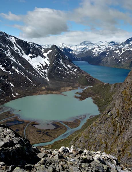
The landscape of Breheimen National Park is defined by its dramatic mountain terrain, formed through hundreds of thousands of years of glacial processes, avalanche activity, and ongoing geological transformation. The Breheimen mountain range rises prominently above the surrounding terrain, with peaks reaching into alpine zones and glacial cirques carved by ancient ice. The park encompasses remarkable topographical diversity, protecting terrain that experiences some of the wettest and driest conditions in Norway simultaneously—the result of complex weather patterns interacting with mountain geography. Visitors encounter a spectrum of landscape types from lush, verdant valleys where historical transhumance farming created pastoral environments, to barren exposed plateaus where vegetation struggles to survive in harsh alpine conditions. Active glaciers remain significant landscape features, continuing the processes that shaped the broader terrain. The combination of soaring peaks, glacial valleys, exposed rock faces, and remnant ice creates a landscape of outstanding natural beauty and geological significance.

Breheimen National Park ecosystems, habitats, and plant life

Breheimen National Park protects an exceptional range of ecological habitats within its 1,671 square kilometre boundary, a diversity that reflects the park's position spanning multiple climate and topographical zones. The environmental gradient from wet western to drier eastern conditions creates distinct ecological communities across relatively short distances. Lush valleys with productive grasslands represent the lower-elevation environments, historically maintained through transhumance farming practices that created and maintained open pastoral landscapes. Moving upward, the terrain transitions through shrub zones and into alpine heath communities adapted to harsh mountain conditions. The barren plateaus represent the most extreme environments within the park, where only the most resilient vegetation survives. Active glaciers and their associated outflow streams add unique aquatic habitats to the park's ecological portfolio. The park's ecological significance is enhanced by its role as a protected area connecting multiple habitat types across an altitudinal gradient, supporting biodiversity in a landscape where environmental conditions change dramatically from valley floor to alpine summit.

Breheimen National Park wildlife and species highlights

The diverse habitats within Breheimen National Park support various wildlife species adapted to Norway's mountain environments. The range of environments—from productive valleys through alpine zones to glacial terrain—creates opportunities for different species communities to inhabit distinct zones within the park. The presence of reindeer in the area is historically significant, with ancient reindeer-hunting traps preserved within the park's boundaries demonstrating the long-standing ecological relationship between humans and these animals in mountain environments. The protected status of the area ensures that wildlife communities can persist in relatively undisturbed conditions, with the park serving as an important refuge for species that require extensive habitat areas. Mountain environments in Norway typically support populations of species including various bird species associated with alpine and cliff habitats, small mammals adapted to rocky terrain, and species that utilize the transitional zones between forest and open mountain terrain.

Breheimen National Park conservation status and protection priorities

Breheimen National Park was established to protect a landscape of outstanding natural value that had remained relatively unmodified by intensive human development despite long history of human use. The park protects geological processes and landforms that represent significant examples of glacial landscape evolution, as well as ecological communities that reflect Norway's mountain environments. The diversity of the park—spanning wet and dry terrain, multiple habitat types, and altitudinal ranges—makes it valuable for biodiversity conservation within Norway's protected area network. The archaeological resources within the park, including the remarkable glacial find of a 300 AD garment, demonstrate the importance of preserving landscapes where both natural and cultural heritage are intertwined. The establishment of the park represents Norway's commitment to maintaining wilderness character in mountain environments, with the 2009 designation adding to the network of Norwegian national parks that collectively protect representative examples of the country's natural landscapes.

Breheimen National Park cultural meaning and human context

The mountains of Breheimen have been inhabited and utilized by humans since the end of the last Ice Age, creating a landscape where natural and cultural history are deeply intertwined. The discovery of a well-preserved man's coat dating to approximately 300 AD from a melting glacier bed in 2011 represents a remarkable archaeological find—not only is this the oldest extant garment found in Norway, but it also demonstrates the long-standing relationship between humans and the glacial environments within what is now the national park. Remains of medieval sælehus shelters—traditional mountain huts used by farmers during the summer grazing season—provide evidence of transhumance practices that shaped the landscape over centuries. Ancient reindeer-hunting traps further attest to the historical use of these mountain environments for subsistence and resource extraction. The park sits within a broader cultural landscape where traditional farming practices, seasonal movement of people and livestock, and close connections to the mountain environment have shaped regional identity. The establishment of the national park has prompted local communities to emphasize their relationship with the protected landscape in development planning and community branding.

Top sights and standout views in Breheimen National Park

Breheimen National Park stands out for its dramatic glacial mountain landscapes, active ice formations, and exceptional topographical diversity within a single protected area. The park's establishment in 2009 makes it one of Norway's more recent national park designations, representing contemporary conservation priorities. The archaeological significance of the 300 AD garment found in a melting glacier adds unique historical dimension to the park's natural values. The contrast between wet and dry terrain within the same park illustrates the complex environmental gradients that characterize Norwegian mountain landscapes. The park's accessibility from gateway communities like Skjolden and Bismo, combined with well-developed trail networks, makes it a destination for hikers seeking to experience Norway's mountain wilderness. The area's long human history—spanning from post-Ice Age presence through medieval period to contemporary outdoor recreation—creates a layered cultural landscape within the protected area.

Best time to visit Breheimen National Park

Breheimen National Park is best experienced during the summer months when hiking trails are fully accessible and the mountain environment is at its most welcoming. The July to September period typically offers the most favorable conditions for backcountry exploration, with snow-free trails allowing access to higher terrain and glacial areas. Summer visitors can experience the full diversity of the landscape, from lush green valleys to flowering alpine meadows. The winter months transform the park into a snow-covered wilderness, with limited accessibility and challenging conditions that appeal to experienced winter mountaineers rather than general visitors. Spring and autumn represent transitional seasons with variable conditions—spring brings melting snow and rising water levels, while autumn offers changing colors but increasingly unpredictable weather. The character of a visit varies considerably by season, with summer providing the most accessible and diverse experience of the park's landscapes and ecosystems.

Park location guide

Geography guide, regional context, and park location map for Breheimen National Park

Breheimen National Park park geography, regions, and map view in Norway
Understand where Breheimen National Park sits in Norway through a broader geographic reading of the surrounding landscape, nearby location context, and its mapped position within the national park landscape.

How Breheimen National Park fits into Norway

Norway, officially the Kingdom of Norway, is a Nordic country in Northern Europe located on the Scandinavian Peninsula. It encompasses mainland Norway, the Arctic islands of Svalbard and Jan Mayen, and maintains dependencies including Bouvet Island and Antarctic claims. The country has a population of about 5.6 million and is bordered by Sweden, Finland, and Russia. Norway is a unitary parliamentary constitutional monarchy with Oslo as its capital and largest city.

Wider geography shaping Breheimen National Park in Norway

Norway occupies the western and northern portions of the Scandinavian Peninsula in Northern Europe. The country shares a long eastern border with Sweden, and borders Finland and Russia to the northeast. Norway has an extensive coastline facing the Skagerrak, North Sea, Norwegian Sea, and Barents Sea. The terrain is predominantly mountainous with numerous fjords along the coastline.

Map view of Breheimen National Park

Use this park location map to pinpoint Breheimen National Park in Norway, understand its exact geographic position, and read its mapped placement within the surrounding landscape more clearly.

Pigeon | © OpenStreetMap contributors

Location context for Breheimen National Park

InnlandetVestland

Visually explore the dramatic glacial landscapes and diverse alpine habitats defining Breheimen National Park.

Breheimen National Park Photos: Visualizing Glacial Landscapes and Alpine Terrain
Browse a curated selection of photos showcasing Breheimen National Park's iconic glacial landscapes, soaring alpine peaks, and diverse protected environments. This visual collection provides essential context for understanding the park's unique geological features, varied habitats, and the dramatic scenery shaped by centuries of ice and geological processes.

Mountain lake landscape with turquoise water, snow-capped peaks, rocky terrain, and scattered clouds under a blue sky

Park atlas

Explore the mapped geography of protected landscapes across Innlandet County and Norway's central mountain ranges, comparing their unique features.

Discover National Parks and Protected Areas Surrounding Breheimen National Park
Browse other national parks and protected areas geographically close to Breheimen National Park, spanning Norway's glacial mountain wilderness and alpine environments in Innlandet. This comparative atlas view allows users to contextualize Breheimen's unique blend of wet and dry terrain alongside similar or contrasting protected landscapes across the region.
National parkVestland

Jostedalsbreen National Park: Europe's Premier Glacial Protected Landscape

Mapped terrain and protected area discovery in Vestland, Norway.

Jostedalsbreen National Park represents a unique geographic entity, safeguarding the largest glacier on the European mainland. This national park, situated in Norway's Vestland region, offers profound insights into glacial landscapes and mountain geography. Users can explore the vast ice mass that dominates the terrain, observe the U-shaped valleys carved by its movement, and understand the geological processes shaping this dynamic environment. The park's protected status highlights its importance for understanding glacial science and preserving a critical component of Norway's natural heritage.

Area
1,310 km²
Established
1991
IUCN
II
Relief
Mountain
Watercolor illustration of a mountain range with green hills and a lake in the foreground
National park

Jotunheimen National Park: Norway's Iconic Alpine Protected Landscape and Geographic Core

Explore mapped glacial terrain and alpine geography.

Jotunheimen National Park stands as a monument to Norway's alpine grandeur, protecting over 1,151 square kilometers of spectacular mountainous terrain. This protected area is defined by its dramatic glacial features, including sharp peaks exceeding 1,900 meters, U-shaped valleys, and pristine alpine lakes, making it a significant focus for geographic exploration and mapped landscape study. Delve into the core of Norway's mountain heartland, understanding the mapped boundaries and regional geological context that shape this iconic protected landscape.

Area
1,151 km²
Established
1980
IUCN
II
Relief
Mountain
National parkInnlandet

Reinheimen National Park: Norway's Vast Protected Wilderness Landscape and Alpine Geography

Map of protected boundaries and diverse mountain terrain.

Reinheimen National Park is a cornerstone of Norway's protected areas, encompassing a substantial portion of Western Norway's alpine wilderness. This national park protects a dynamic landscape characterized by dramatic western peaks and gentler eastern plateaus, providing critical habitat for wild reindeer and other wildlife. Its extensive mapped boundaries and varied natural terrain offer a rich subject for geographic discovery and atlas exploration, highlighting the ecological significance of well-preserved mountain ecosystems within Innlandet.

Area
1,969 km²
Established
2006
IUCN
II
Relief
Mountain
Watercolor painting of mountain peaks with green valleys and grassy foreground
National parkInnlandet

Rondane National Park: Norway's Premier Alpine Protected Landscape and Historic National Park

Mapped glacial terrain, iconic peaks, and wild reindeer sanctuary.

As Norway's first national park, Rondane offers a profound exploration of a protected alpine environment. Situated in Innlandet county, its 963 square kilometers showcase a landscape sculpted by glaciers, featuring a striking array of ten peaks exceeding 2,000 meters. This page details Rondane National Park's distinct mapped boundaries, dramatic mountain geography, and its ecological significance as a refuge for wild reindeer, making it a cornerstone of Scandinavian natural heritage.

Area
963 km²
Established
1962
IUCN
II
Relief
Mountain
Abstract watercolor landscape with soft pastel hues of green, pink, yellow, and purple
National park

Hallingskarvet National Park: Norway's High Mountain Plateau and Protected Wilderness

Mapping glacial terrain, alpine environments, and wild reindeer habitat.

Hallingskarvet National Park offers a unique window into Norway's geological history and alpine ecology. This protected landscape encompasses the striking Hallingskarvet plateau and the Vargebreen glacier, along with deep valleys carved by ancient ice. Users can explore the park's mapped boundaries, understand its regional geographic setting in Scandinavia, and appreciate its conservation value as a habitat for wild reindeer. The park's terrain provides a concrete example of glacial shaping and high-altitude ecosystems within the Nordic context.

Area
450 km²
Established
2006
IUCN
II
Relief
Mountain
Watercolor painting showing a mountainous landscape with a waterfall, grassy fields, and wildflowers
National parkInnlandet

Dovrefjell, Sunndalsfjella National Park: Mapping Norway's Largest Alpine Protected Landscape

Explore its protected boundaries, mountain terrain, and unique ecological significance.

Dovrefjell, Sunndalsfjella National Park is a cornerstone of Norwegian protected areas, offering an expansive alpine wilderness with dramatic mountain scenery. This page details the park's geographic context, mapped landscape features, and its importance as a refuge for unique wildlife like wild reindeer and muskox. Users can investigate the park's protected boundaries and understand its role within the regional geography of Innlandet, contributing to a structured atlas of Scandinavia's natural heritage.

Area
1,693 km²
Established
2002
IUCN
II
Relief
Mountain
National parkInnlandet

Dovre National Park: Mapped Alpine Terrain & Protected Reindeer Habitat in Innlandet

Norway's protected mountain plateau landscape and wildlife corridor.

Dovre National Park is a significant protected area in Innlandet, Norway, characterized by its expansive alpine plateau terrain and role as a vital ecological corridor for wild reindeer. This national park offers users an atlas-level view of its mapped natural boundaries, focusing on the unique subarctic mountain landscape and its conservation importance. Understand Dovre National Park's geographic identity and its contribution to a contiguous network of protected lands.

Area
289 km²
Established
2003
IUCN
II
Relief
Mountain
National parkInnlandet

Langsua National Park: Protected Mountain Forests and Inland Wilderness in Innlandet, Norway

Discover mapped boundaries and regional geographic context.

Langsua National Park, a designation expanded in 2011, is a prominent protected area in Norway's Innlandet county. This national park encompasses 537.1 square kilometers of diverse mountainous terrain, characterized by extensive mountain forests and inland wilderness habitats. Its creation consolidates fragmented nature reserves into a significant contiguous protected landscape, offering valuable insight into Norway's conservation strategies and the geographic context of its eastern mountain regions.

Area
537.1 km²
Established
2011
IUCN
II
Relief
Mixed relief

Common questions about visiting, size, designation, and location context for Breheimen National Park

Breheimen National Park FAQs for park facts, access, geography, and protected area context
Find quick answers about Breheimen National Park, including protected-area facts, park geography, trail and visitor context, and how the park fits into its surrounding country and regional landscape.
MoriAtlas Explorer

Continue Your Protected Areas Search Across the Global Atlas

Deepen your exploration by continuing the structured search for national parks and protected areas worldwide. Utilize the comprehensive filtering capabilities to compare different conservation landscapes and refine your understanding of global park geography. Discover more about the distribution and characteristics of protected natural areas.

Global natural geography