Mori Atlas logo
National parkBuzuluksky Bor National Park

Discover the unique geography and protected landscape of this ancient dune formation surrounded by steppe.

Buzuluksky Bor National Park: Mapping Russia's Largest Isolated Pine Forest on the East European Plain

Buzuluksky Bor National Park represents a remarkable natural phenomenon on the East European Plain, safeguarding the planet's largest isolated grove of high pine trees. This national park, situated on a deep sandy substrate derived from ancient marine sediments, stands as a distinct ecological island amidst expansive dry steppe grasslands. Its triangular expanse, measuring approximately 53 by 34 kilometers, offers a profound geographic contrast and a unique setting for atlas-driven exploration of protected landscapes and their regional context.

Pine ForestsSteppe EcosystemsIsolated ForestEuropean RussiaBirdwatchingWetland Habitats

Buzuluksky Bor National Park

National park

Park overview

Structured park overview, official facts, and landscape profile for Buzuluksky Bor National Park

Buzuluksky Bor National Park park facts, protected area profile, and essential visitor context
Review the core facts for Buzuluksky Bor National Park, including designation, size, terrain, visitor scale, habitats, and operating context in one park-focused overview.

About Buzuluksky Bor National Park

Buzuluksky Bor National Park represents one of the most ecologically distinctive protected areas in Russia, protecting an isolated pine forest that defies the surrounding steppe landscape. The forest was created by wind and water over the sand dunes of the ancient Caspian Sea, beginning several hundred thousand years ago, and today overlays shifting sand dunes that reach depths of 30 meters. The park's governing body is the Ministry of Natural Resources and Environment of Russia, and the official designation as a national park in 2007 formalized protections that had existed under forestry management for over a century. Visitors can explore hiking trails throughout the park, with designated areas for group meetings and camping, while a museum displays historical and natural exhibits. The park's charter strictly prohibits development, resource extraction, construction, trunk roads, and any disturbance to geological or hydrological features. Hunting, fishing, and unauthorized motorized vehicles are also prohibited, ensuring the forest remains a protected habitat.

Quick facts and research context for Buzuluksky Bor National Park

The park covers roughly 106,000 hectares, measuring about 53 kilometers north-south and 34 kilometers west-east. It is bounded to the south by the Samara River, while the Borovka River flows southwest through the forest center, carving a valley approximately 100 meters deep. The forest has been a forestry management area since the early 1800s and was officially designated as a National Park in 2007. The surrounding steppe experiences a continental climate with hot summers and cold winters, with average precipitation of 530 millimeters per year. The park creates a distinct mesoclimate that influences the surrounding region up to 20 kilometers away, producing cooler temperatures and wetter conditions than the surrounding steppe.

Park context

Deeper park guide and search-rich context for Buzuluksky Bor National Park

Buzuluksky Bor National Park history, landscape, wildlife, and travel context
Explore Buzuluksky Bor National Park through its history, landscape character, ecosystems, wildlife, conservation priorities, cultural context, and seasonal travel timing in a structured park guide built for atlas discovery and search intent.

Why Buzuluksky Bor National Park stands out

Buzuluksky Bor is world-renowned as the largest isolated grove of high pine trees on the planet, a remarkable ecological phenomenon where a dense coniferous forest exists as an island surrounded entirely by steppe grasslands. This makes it a natural laboratory for studying forest-steppe dynamics, dune stabilization, and ecological adaptation. The park also holds significance as the site of the earliest forest management area in Russia, with forestry experiments conducted since the early 1900s. The combination of the ancient dune-formed landscape, the deep sandy substrate, and the unique position at the boundary between European forest and Asian steppe gives this park exceptional scientific and ecological value.

Buzuluksky Bor National Park history and protected-area timeline

The Buzuluk Pine Forest has ancient origins, formed by wind and water working over the sand dunes of the ancient Caspian Sea over several hundred thousand years. The area may have served as the mouth of a larger river that flowed into the Caspian until the sea receded. Until the early 1800s, the area contained extensive bogs and marshes that have since been replaced by forest as the ecosystem evolved. A forestry management center was established in the early 1900s, marking the beginning of systematic forest management in the region. Since that time, extensive experiments have been conducted in forestation of steppe environments, making this area a pioneering site for Russian forestry science. The park was officially constituted as a National Park in 2007, transitioning from forestry management to full national park protection. The park contains a legacy of oil extraction conducted from the 1950s to the 1970s, with about 160 capped oil wells remaining in the park today.

Buzuluksky Bor National Park landscape and geographic character

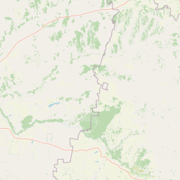
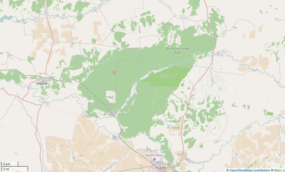
The park occupies a distinctive triangular patch of forest measuring roughly 53 kilometers north-south and 34 kilometers west-east. The pine stand sits within a large hollow filled with sandy sediments of marine origin, overlain by alluvial sands that reach depths of 90 meters. The Borovka River flows southwest through the middle of the forest before emptying into the Samara River at its southern end, creating a valley approximately 100 meters deep below the surrounding terrain. The sandy floodplain above the Borovka valley contains creeks and oxbow lakes. At some points, the river banks expose red sandstones, conglomerates, and mudstones of Permian and Lower Triassic age. The forest is surrounded by a thin band of broadleaf trees that transition to the open steppe beyond. Even today, the forest overlays shifting sand dunes up to 30 meters in depth, a reminder of its ancient formation.

Buzuluksky Bor National Park ecosystems, habitats, and plant life

The park exists within the Pontic-Caspian steppe ecoregion, characterized by temperate grasslands, savannas, and shrublands biome, making the forest an ecological anomaly in its surroundings. The forest canopy comprises both conifers and deciduous trees, creating a complex habitat that contrasts sharply with the surrounding steppe. The park creates a special mesoclimate that influences the surrounding region up to 20 kilometers from the forest edge, producing cooler temperatures, wetter soil conditions, greater vegetation variety, and more tree cover than the surrounding steppe. The continental climate features hot summers and cold winters, with mean temperatures ranging from -13.8°C in January to +20.4°C in July. Average precipitation is 530 millimeters per year, with snow cover lasting approximately 169 days under the forest canopy from mid-November to mid-April.

Buzuluksky Bor National Park wildlife and species highlights

The animal community of Buzuluksky Bor reflects the combination of forest, steppe, and wetland habitats that exist in close connection within the park. The diverse plant life supports 55 mammal species, ranging from small rodents such as squirrels and hamsters to forest-dwelling animals including wolves, foxes, badgers, pine martens, ferrets, minks, ermine, and weasels. Large ungulates including moose, elk, wild boar, and roe deer also inhabit the area, while wolves migrate through as predators. The park supports seven species of bats that feed on forest insects and migrate during winter months. Bird diversity is notable, with 155 species present including birds of prey such as owls and hawks that feed on rodents. The variety of microhabitats supports waterfowl, forest birds, and bush-nesting species. Notably, beavers reappeared in the 1980s and have built dams in the rivers and floodplain lakes.

Buzuluksky Bor National Park conservation status and protection priorities

Buzuluksky Bor holds significant conservation value as the world's largest isolated pine forest, representing a unique ecological phenomenon that requires protection and study. The park serves as a living laboratory for understanding forest-steppe interactions and dune stabilization processes. However, the park faces significant environmental challenges, including recurrent drought that dries trees and creates favorable conditions for pine infestations. A severe windstorm in 2010 felled nearly 10% of the pine trees, and forest fires in 2013 caused additional damage. The presence of approximately 160 capped oil wells from historical extraction raises concerns about potential leaks and environmental contamination. Proposals to explore additional oil resources or to properly conserve the existing wells remain under debate, highlighting ongoing tensions between resource development and conservation priorities.

Top sights and standout views in Buzuluksky Bor National Park

The park's defining feature is its status as the largest isolated pine forest in the world, a natural phenomenon where coniferous forest exists as an island within steppe grassland. The deep sandy substrate reaching 90 meters, the ancient dune formations up to 30 meters deep, and the Borovka River valley cutting 100 meters below the surrounding terrain create a unique geological setting. The forest's creation from the ancient Caspian Sea's sand dunes over hundreds of thousands of years makes it a living record of geological history. As the site of the earliest forest management area in Russia, the park also holds historical significance for forestry science. The park creates a measurable mesoclimate effect on the surrounding steppe, influencing conditions up to 20 kilometers away.

Best time to visit Buzuluksky Bor National Park

The park experiences a continental climate with distinct seasons that significantly affect the visit experience. Summer months offer warm conditions ideal for hiking and exploring the forest trails, though temperatures can be hot. Winter brings cold conditions with snow cover typically from mid-November to mid-April, lasting about 169 days under the forest canopy. The most comfortable time for outdoor activities would likely be late spring through early autumn, when temperatures are moderate and the forest is accessible. The winter months, while cold, offer a different perspective of the pine forest under snow, though access may be more limited. Visitors interested in wildlife viewing should consider that many bird species and bats migrate away during winter months.

Park location guide

Geography guide, regional context, and park location map for Buzuluksky Bor National Park

Buzuluksky Bor National Park park geography, regions, and map view in Russia
Understand where Buzuluksky Bor National Park sits in Russia through a broader geographic reading of the surrounding landscape, nearby location context, and its mapped position within the national park landscape.

How Buzuluksky Bor National Park fits into Russia

Russia is a transcontinental nation spanning eleven time zones, bordered by fourteen countries. It is the world's largest country by area, covering 17,098,246 km². Moscow is the capital and largest city, while Saint Petersburg is the second-largest and a major cultural centre.

Wider geography shaping Buzuluksky Bor National Park in Russia

Russia spans Eastern Europe and North Asia, covering 17,098,246 km². It shares land borders with fourteen countries, more than any other nation, and spans eleven time zones. The landscape includes vast plains, mountain ranges such as the Urals and Caucasus, and extensive coastlines along the Arctic Ocean, Pacific Ocean, Baltic Sea, Black Sea, and Caspian Sea.

Map view of Buzuluksky Bor National Park

Use this park location map to pinpoint Buzuluksky Bor National Park in Russia, understand its exact geographic position, and read its mapped placement within the surrounding landscape more clearly.

Pigeon | © OpenStreetMap contributors

Location context for Buzuluksky Bor National Park

Orenburg OblastSamara Oblast
Park atlas

Discover the regional spread of protected landscapes, comparing ecological islands within the expansive East European Plain.

Explore Other National Parks and Protected Areas Near Buzuluksky Bor National Park
Browse a curated selection of national parks and protected areas located geographically near Buzuluksky Bor National Park, encompassing distinct pine forest islands within expansive steppe ecosystems. Deepen your understanding of regional conservation efforts and compare diverse protected landscapes by tracing their distribution and unique characteristics on an atlas view.
National parkSaratov Oblast

Khvalynsky National Park: Protected Landscape and Regional Geography Atlas

Discover mapped park boundaries in Saratov Oblast

Khvalynsky National Park is a significant protected area designated as a national park within the Saratov Oblast. This entry provides detailed atlas-based insights into its geographic scope, protected landscape features, and its context within the wider regional geography of Southeastern European Russia. Explore the mapped terrain and understand how this park contributes to the conservation landscape of the Volga region.

Area
255 km²
Established
1994
IUCN
II
Visitors
35K annual
National parkBashkortostan

Bashkiriya National Park: Karst Geography and Protected Ural Forest Landscape

Explore Ural Mountains national park mapped boundaries and terrain.

Delve into the geography and protected landscape of Bashkiriya National Park, a significant national park within Russia's Bashkortostan region. This detailed page highlights its striking karst topography, extensive cave systems, and over 92 percent forest cover across the southern Ural Mountains. Understand the park's role as a conservation buffer zone and its unique position at the Europe-Asia biogeographical boundary through structured geographic data and mapped context.

Area
920 km²
Established
1986
IUCN
II
Relief
Mixed relief
National parkTatarstan

Nizhnyaya Kama National Park: Protected Area and Geographic Context in Tatarstan

Discover mapped boundaries and regional landscape insights.

Nizhnyaya Kama National Park serves as a distinct protected area within the republic of Tatarstan, Russia. This detail page provides essential geographic context and map-oriented information, focusing on the park's boundaries and its contribution to the regional landscape. It is designed for users seeking structured data on protected lands, offering a factual entry point for understanding this Russian national park within a broader atlas framework.

Area
265.87 km²
Established
1991
IUCN
II
Relief
Lowland
National parkUdmurt Republic

Nechkinsky National Park: Protected River Valley Landscape and Archaeological Heritage

Explore Udmurt Republic's National Park Geography and Terrain

Nechkinsky National Park, situated in the Udmurt Republic, is a vital protected area distinguished by its prominent river valley landscape. The park's geography features a stark contrast between steep right-bank slopes and a wide, flat left-bank floodplain, bordered by the Votkinsk reservoir. This unique terrain supports diverse ecosystems and preserves thousands of years of archaeological heritage, making it a focal point for understanding the region's natural and cultural map.

Area
208 km²
Established
1997
IUCN
II
Watercolor illustration of a mountain range with purple peaks, green hills, a single tall pine tree, and pinkish foreground vegetation
National parkChelyabinsk Oblast

Zigalga National Park: National Park within Chelyabinsk Oblast's Southern Urals Geography

Mapped protected landscape and regional geographic context for atlas discovery.

Zigalga National Park offers a specific focus for exploring protected natural areas in Russia's Chelyabinsk Oblast. This page provides essential geographic data, detailing the park's mapped boundaries and its position within the Southern Urals region. Understand the park's unique protected landscape identity and its contribution to the atlas of Russian natural areas, fostering detailed map-based exploration and regional geographic understanding.

Area
457 km²
Established
2019
IUCN
II
National parkRepublic of Mordovia

Smolny National Park: National Park Protected Area and Geographic Context in Republic of Mordovia

Explore the mapped landscape and regional geography of Smolny National Park.

Delve into the specifics of Smolny National Park, a designated national park in Russia's Republic of Mordovia. This detailed atlas view focuses on its protected area identity and geographic setting, providing essential context for understanding its landscape. Discover the mapped boundaries and regional placement that define this protected territory, crucial for any structured exploration of Russian natural areas.

Area
365 km²
Established
1995
IUCN
II
Relief
Lowland
National parkChelyabinsk Oblast

Zyuratkul National Park: Protected Landscape Atlas and Regional Geography

Explore national park boundaries and terrain in Chelyabinsk Oblast.

Zyuratkul National Park represents a distinct protected landscape within the Chelyabinsk Oblast of Russia. This page offers an atlas-centric view, detailing its geographic position and significance as a national park. Users can explore the mapped context of Zyuratkul National Park, understanding its terrain and its contribution to the protected areas landscape of the Southern Urals region.

Area
882.49 km²
Established
1993
IUCN
II
Relief
Mountain
National parkKomi Republic

Koygorodsky National Park: Protected Landscape Exploration and Regional Geography

Mapped boundaries and natural landscape context.

Gain a structured understanding of Koygorodsky National Park, a designated national park within the Komi Republic. This entry facilitates exploration of its protected landscape, mapped geographic features, and its role within the broader regional atlas. Focus on the park's identity as a distinct protected area and its contribution to understanding Russian natural geography through detailed, map-centric data.

Area
567 km²
Established
2019
IUCN
II

Common questions about visiting, size, designation, and location context for Buzuluksky Bor National Park

Buzuluksky Bor National Park FAQs for park facts, access, geography, and protected area context
Find quick answers about Buzuluksky Bor National Park, including protected-area facts, park geography, trail and visitor context, and how the park fits into its surrounding country and regional landscape.
MoriAtlas Explorer

Continue Your Protected Areas Search Across the Global Atlas

Deepen your exploration by continuing the structured search for national parks and protected areas worldwide. Utilize the comprehensive filtering capabilities to compare different conservation landscapes and refine your understanding of global park geography. Discover more about the distribution and characteristics of protected natural areas.

Global natural geography