Mori Atlas logo
National parkKytalyk National Park

Discover the mapped boundaries and regional context of this protected natural area.

Kytalyk National Park: Protected Landscape within Sakha Republic's Geography

(National Park Kytalyk)

Kytalyk National Park represents a key protected landscape within the immense geographic expanse of the Sakha Republic in Russia's Far East. As a designated national park, it serves as a crucial point for understanding regional conservation efforts and mapped natural territories. MoriAtlas provides detailed geographic context for Kytalyk National Park, allowing for exploration of its protected boundaries and its place within the broader Siberian atlas.

Arctic tundraNational parkMigratory bird sanctuarySiberian craneWetlandsPermafrost landscape

Kytalyk National Park

National park

Park overview

Structured park overview, official facts, and landscape profile for Kytalyk National Park

Kytalyk National Park park facts, protected area profile, and essential visitor context
Review the core facts for Kytalyk National Park, including designation, size, terrain, visitor scale, habitats, and operating context in one park-focused overview.

About Kytalyk National Park

Kytalyk National Park occupies a remarkable position in Russia's protected area network as a newly established sanctuary for Arctic biodiversity in one of the most remote regions of the country. The park is situated in the Yana-Indigirka Lowland, on the flat, low-lying tundra of the Indigirka River delta where the river empties into the East Siberian Sea. This coastal position places the park at a critical junction between terrestrial and marine Arctic ecosystems. The establishment of Kytalyk National Park in 2020 reflects growing recognition of the importance of protecting Russia's Arctic tundra habitats, particularly those that serve as essential breeding and nesting grounds for migratory waterbirds that travel between wintering grounds in East Asia and breeding areas in the Russian Far North. The park's extensive area of nearly 1.9 million hectares encompasses a complex landscape of wetlands, marshes, thermokarst depressions, and coastal tundra that provides habitat for a remarkable diversity of Arctic-adapted species despite the harsh environmental conditions.

Quick facts and research context for Kytalyk National Park

Kytalyk National Park is located in Allaikhovsky District of the Sakha Republic in northern Russia, on the delta of the Indigirka River where it meets the East Siberian Sea. The park covers approximately 1.9 million hectares, making it one of the larger protected areas in Russia's Arctic region. It was officially established in September 2020 under the governance of FGBU Kytalyk. The park is recognized as an IUCN Category II protected area and serves as a crucial refuge for migratory birds on the East Asian–Australasian Flyway, particularly the globally endangered Siberian crane.

Park context

Deeper park guide and search-rich context for Kytalyk National Park

Kytalyk National Park history, landscape, wildlife, and travel context
Explore Kytalyk National Park through its history, landscape character, ecosystems, wildlife, conservation priorities, cultural context, and seasonal travel timing in a structured park guide built for atlas discovery and search intent.

Why Kytalyk National Park stands out

Kytalyk National Park is best known as a globally significant sanctuary for the critically endangered Siberian crane. The park protects a substantial portion of the species' Arctic breeding grounds along the East Asian, Australasian Flyway, making it one of the most important nesting areas for this iconic bird in the world. Beyond its crane conservation role, the park also contains the Berelekh mammoth cemetery on its southern edge, a renowned paleontological site where scientists have discovered a mass burial site containing the remains of over 140 mammoths. The park's extensive Arctic coastal tundra ecosystem, with its distinctive thermokarst landforms and wetland habitats, represents a relatively intact polar environment of considerable scientific and ecological value.

Kytalyk National Park history and protected-area timeline

Kytalyk National Park was officially established on September 11, 2020, though the process of creating the protected area began in 2019. The creation of this protected area represented a significant addition to Russia's network of protected areas focused on Arctic ecosystems and migratory bird conservation. The park was established under the governance of FGBU Kytalyk, the federal budget institution responsible for managing the protected area. The establishment of the park was particularly significant because it formalized protection for one of the most important breeding grounds for the Siberian crane along the East Asian–Australasian Flyway, a major migratory bird pathway that stretches from Arctic breeding areas in Siberia to wintering grounds as far south as China, Japan, and Southeast Asia. The park was created to ensure the long-term preservation of these critical breeding habitats and the species that depend upon them.

Kytalyk National Park landscape and geographic character

The landscape of Kytalyk National Park is characterized by the flat, low-lying terrain of the Arctic coastal tundra in the Yana-Indigirka Lowland. The terrain averages just 50 to 80 meters above sea level, making this one of the lowest-lying protected areas in Russia's northern regions. The park's terrain has been shaped by the combined effects of water and ice in the permafrost soils, creating distinctive Arctic landforms including thermokarst depressions, pingos (ice-cored hills), baydzharakhs (earth mounds), and alas depressions. The delta of the Indigirka River creates an extensive network of wetlands, marshes, and shallow water bodies across the park. The soil remains permanently frozen except during a brief summer thaw from mid-June to mid-September, when the active layer thaws to depths ranging from 0.2 to 1.8 meters. Because the permafrost prevents water from draining downward, the landscape is characterized by waterlogged, marshy conditions throughout much of the park. Peat bogs are a prevalent feature across the terrain, reflecting the combination of cold temperatures, moisture retention, and limited decomposition that characterizes Arctic wetland environments.

Kytalyk National Park ecosystems, habitats, and plant life

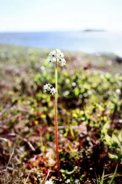
The nature of Kytalyk National Park is defined by its position within the Northeast Siberian coastal tundra ecoregion and the extreme environmental conditions that characterize Arctic tundra ecosystems. The park experiences a true tundra climate with at least one month where average temperatures rise above freezing to melt snow, but no month with average temperatures exceeding 10°C. This results in an extremely short growing season of only 60 to 90 days, which severely limits the types of vegetation that can survive in the park. The flora is dominated by species adapted to saline meadow conditions, including Puccinellia phryganodes (a salt grass), Carex subspathacea (Hoppner's sedge), Cochlearia arctica (an Arctic scurvy-grass), and Stellaria humifusa (Saltmarsh starwort). Mosses, particularly Sphagnum species, cover up to 50% of the terrain, represented by over 100 species. The park has recorded 221 species of vascular plants, though the herbaceous vegetation rarely exceeds 25 centimeters in height due to the harsh growing conditions. Approximately 70 species of lichen are also present, adding to the diversity of plant life in this Arctic environment.

Kytalyk National Park wildlife and species highlights

The wildlife of Kytalyk National Park reflects the specialized adaptations required to survive in Arctic tundra environments. The park supports 21 species of mammals, including notable Arctic species such as Brown lemming, Arctic lemming, Muskrat, and Musk ox, all of which are adapted to the extreme cold and seasonal fluctuations of the tundra ecosystem. The park is particularly significant for its bird life, with 96 species recorded within its boundaries and 63 of these species breeding within the park. This makes the park an important breeding ground for many migratory bird species. The 84 species of terrestrial invertebrates and 28 species of fish further contribute to the biodiversity of this Arctic protected area. However, the most significant wildlife value of the park lies in its role as a critical breeding and nesting area for the critically endangered Siberian crane, which uses the park's wetlands and tundra meadows as essential habitat during the breeding season.

Kytalyk National Park conservation status and protection priorities

Kytalyk National Park represents a significant conservation achievement for Arctic biodiversity protection in Russia. The park is designated as an IUCN Category II protected area, reflecting its primary purpose of protecting natural ecosystems. The most critical conservation value of the park lies in its protection of breeding grounds for the Siberian crane, a species classified as critically endangered by international conservation authorities. The park protects a significant portion of the species' breeding sites along the East Asian–Australasian Flyway, one of the world's major migratory bird flyways. By establishing formal protection for these critical breeding habitats, the park helps ensure the survival of this endangered species during its breeding season. The park also conserves an extensive area of relatively intact Arctic coastal tundra, protecting the complex of wetlands, thermokarst features, and tundra ecosystems that characterize this region of Russia's Far North. Additionally, the Berelekh mammoth cemetery within the park represents a significant paleontological heritage site requiring protection.

Kytalyk National Park cultural meaning and human context

The cultural context of Kytalyk National Park is deeply connected to the indigenous Yakut people of the Sakha Republic. The park's name, Kytalyk, derives directly from the Yakut language and specifically refers to the Siberian crane, reflecting the cultural significance of this iconic bird to the local communities. The Sakha Republic, also known as Yakutia, is the largest region in Russia and is home to the Yakut people who have lived in harmony with the harsh Arctic environment for centuries. While the park itself does not contain evidence of significant historical human settlement due to its remote and extreme environmental conditions, the broader region has been inhabited by indigenous peoples who have interacted with the landscape and its wildlife over generations. The naming of the park in the Yakut language demonstrates the continued connection between the protected area and the cultural heritage of the region.

Top sights and standout views in Kytalyk National Park

Kytalyk National Park's standout features include its role as a globally important breeding ground for the critically endangered Siberian crane, one of the rarest and most iconic crane species in the world. The park protects nearly 1.9 million hectares of Arctic coastal tundra, making it one of Russia's larger national parks and a significant addition to Arctic protected area networks. The park contains the Berelekh mammoth cemetery, a remarkable paleontological site where over 140 mammoth skeletons have been discovered, providing scientific insights into Pleistocene fauna. The park's landscape of thermokarst depressions, pingos, and extensive wetlands represents a relatively intact Arctic environment shaped by permafrost and extreme cold. The park also supports significant biodiversity including 96 bird species, 21 mammal species, and over 220 vascular plant species, all adapted to the challenging Arctic conditions.

Best time to visit Kytalyk National Park

The best time to visit Kytalyk National Park would be during the brief Arctic summer, when temperatures rise above freezing and the landscape comes alive with the short growing season. The thawing period occurs from mid-June to mid-September, with July and August typically offering the most favorable conditions for viewing the tundra landscape and its wildlife. During this period, visitors can observe the migratory birds that breed in the park, including the endangered Siberian crane. However, it is important to note that the park is located in one of the most remote regions of Russia, with access difficult due to the lack of infrastructure and the extreme isolation of the area. The nearest settlement is Chokurdakh, and reaching the park requires careful planning and specialized logistics appropriate for Arctic travel.

Park location guide

Geography guide, regional context, and park location map for Kytalyk National Park

Kytalyk National Park park geography, regions, and map view in Russia
Understand where Kytalyk National Park sits in Russia through a broader geographic reading of the surrounding landscape, nearby location context, and its mapped position within the national park landscape.

How Kytalyk National Park fits into Russia

Russia is a transcontinental nation spanning eleven time zones, bordered by fourteen countries. It is the world's largest country by area, covering 17,098,246 km². Moscow is the capital and largest city, while Saint Petersburg is the second-largest and a major cultural centre.

Wider geography shaping Kytalyk National Park in Russia

Russia spans Eastern Europe and North Asia, covering 17,098,246 km². It shares land borders with fourteen countries, more than any other nation, and spans eleven time zones. The landscape includes vast plains, mountain ranges such as the Urals and Caucasus, and extensive coastlines along the Arctic Ocean, Pacific Ocean, Baltic Sea, Black Sea, and Caspian Sea.

Map view of Kytalyk National Park

Use this park location map to pinpoint Kytalyk National Park in Russia, understand its exact geographic position, and read its mapped placement within the surrounding landscape more clearly.

Pigeon | © OpenStreetMap contributors

Location context for Kytalyk National Park

Allaikhovsky DistrictSakha Republic
Park atlas

Browse surrounding Arctic landscapes and compare conservation efforts across Russia's northern protected regions.

Explore Other National Parks and Protected Areas Near Kytalyk National Park
After discovering Kytalyk National Park, trace the regional spread of national parks and protected areas across Russia's vast Arctic and Far Eastern territories. Explore diverse Arctic tundra ecosystems and compare the unique permafrost landscapes and wildlife conservation priorities found in adjacent protected regions.
National parkChukotka Autonomous Okrug

Beringia National Park: Protected Arctic Tundra and Land Bridge History in Chukotka

Mapped geography and protected landscape of a remote Russian national park.

Beringia National Park in the Chukotka Autonomous Okrug safeguards an extraordinary expanse of subarctic tundra, embodying the historical land bridge that once linked Asia and North America. This protected area offers a unique window into paleobiological history and pristine Arctic wilderness. Explore its vast mapped terrain, understand its geographic significance at the Bering Strait, and appreciate the context of its protected landscape within the broader regional geography of Russia's Far East.

Area
30,532 km²
Established
2013
IUCN
II
Relief
Mixed relief
Watercolor illustration showing green hills, a river, and grassy foreground
Nature reserveSakha Republic

Lena Pillars Nature Reserve: Mapped Protected Area in Sakha Republic's Vast Geography

Explore the regional landscape and park boundaries.

Discover Lena Pillars Nature Reserve, a key protected area located within the expansive Sakha Republic of Russia. This page offers focused atlas exploration, detailing the park's geographic setting and its mapped boundaries against the backdrop of Siberia's largest federal subject. Understand the unique natural landscape context and its significance within regional conservation efforts, providing structured geographic data for your exploration.

Area
13,870 km²
Relief
Lowland
Climate
Subpolar
Access
Moderate access
National parkKhabarovsk Krai

Shantar Islands National Park: Remote Archipelago Atlas with Rugged Terrain

Mapping protected marine and island geography in Khabarovsk Krai.

Shantar Islands National Park represents a significant protected landscape within Khabarovsk Krai, notable for its dramatic coastal geography, mountainous terrain, and rich marine ecosystems. This national park, encompassing a chain of islands in the Sea of Okhotsk, is a vital habitat for marine mammals and seabird colonies. Explore its mapped boundaries and unique regional atlas context, understanding its role as a protected coastal area in the Russian Far East.

Area
5,155 km²
Established
2013
IUCN
II
Relief
Mountain
National parkAmur Oblast

Tokinsko-Stanovoy National Park: Protected Landscape Geography and Atlas Context

National Park in Amur Oblast, Russia

Delve into the specifics of Tokinsko-Stanovoy National Park, a designated national park within Amur Oblast. This entry provides essential context on its protected landscape characteristics and its place in the regional geography. Understand the park's mapped boundaries and discover its natural terrain as part of a larger atlas-driven exploration of protected areas in the Russian Far East.

Area
2,430 km²
Established
2019
IUCN
II
Protected areaKamchatka Krai

Commander Islands Protected Area: Detailed Map and Regional Geographic Context

Explore protected landscapes in Kamchatka Krai.

Delve into the Commander Islands Protected Area, a significant protected landscape located within the vast geography of Kamchatka Krai. This detailed entry provides essential atlas-level context, focusing on the park's mapped boundaries and its position within the regional landscape. Understand the protected area's geographic identity and its role in the natural terrain of the Russian Far East through our structured exploration tools.

Area
1,846 km²
Relief
Mixed relief
Climate
Subpolar
Access
Remote access
National parkZabaykalsky Krai

Kodar National Park: Protected National Park with Zabaykalsky Krai Geographic Context

Atlas exploration of mapped boundaries and regional landscape.

Delve into the protected landscape of Kodar National Park, a significant national park located in Zabaykalsky Krai, Russia. This resource provides detailed insights into its geographic setting, offering users a clear view of its mapped boundaries and its position within the regional atlas. Understand the protected-area nature of Kodar National Park and its contribution to the mapped natural landscapes of its geographical vicinity.

Area
4,917 km²
Established
2016
IUCN
II
Relief
Mountain
Watercolor painting of a river flowing through green hills with pink flowering trees and distant mountains under a light sky
National parkKhabarovsk Krai

Anyuysky National Park: Mapped Protected Landscape and Geographic Setting in Khabarovsk Krai

Explore its unique terrain and ecological corridor status.

Delve into Anyuysky National Park, a crucial protected area in Khabarovsk Krai known for its role as an ecological corridor linking the Amur River floodplain to the Sikhote-Alin mountains. This page provides detailed insight into the park's mapped landscape, from its western alluvial plains to its eastern mountain canyons, highlighting its distinct geographic features and the diverse habitats it safeguards. Understand its significance as a protected zone and its place within the regional geography for atlas-based discovery.

Area
4,294 km²
Established
1999
IUCN
II
Relief
Mixed relief
Watercolor illustration of rolling green hills with distant mountains and a light sky
National park

Russian Arctic National Park: Russia's Premier Northernmost Protected Landscape

Arctic Islands, Glacial Terrain, and Marine Mammal Habitats

Russian Arctic National Park preserves some of the planet's most remote and pristine Arctic environments across the Novaya Zemlya and Franz Josef Land archipelagos. This protected area offers unparalleled insight into Arctic geography, showcasing dramatic glacial landscapes, extensive seabird colonies, and critical feeding grounds for polar bears and bowhead whales. Explore the park's unique protected landscape and its significance within the broader atlas of global conservation efforts.

Area
14,260 km²
Established
2009
IUCN
II
Relief
Lowland

Common questions about visiting, size, designation, and location context for Kytalyk National Park

Kytalyk National Park FAQs for park facts, access, geography, and protected area context
Find quick answers about Kytalyk National Park, including protected-area facts, park geography, trail and visitor context, and how the park fits into its surrounding country and regional landscape.
MoriAtlas Explorer

Continue Your Protected Areas Search Across the Global Atlas

Deepen your exploration by continuing the structured search for national parks and protected areas worldwide. Utilize the comprehensive filtering capabilities to compare different conservation landscapes and refine your understanding of global park geography. Discover more about the distribution and characteristics of protected natural areas.

Global natural geography