
Islands
Park geography
Detailed marine area measurements, spatial coordinates, and coastal landscape characteristics
Comprehensive Geographic Profile and Mapped Boundaries of Point Hicks Marine National Park
Point Hicks Marine National Park encompasses 40 square kilometers of protected marine habitat within the Bass Strait. This geographic profile details the park boundaries, spatial coordinates, and coastal terrain features; providing a structured overview of the area as it exists along the Australian coastline.
Related tags
marine protected areaVictoria marine parksEast Gippslandwarm-temperate marine ecosystemsshipwreck heritage
Victoria's eastern gateway to warmer-temperate marine ecosystems and historic shipwreck heritage
Point Hicks Marine National Park
Point Hicks Marine National Park is a protected marine area off the southeastern coast of Victoria, Australia, representing one of the state's warmer eastern marine environments. Established in November 2002, the 4,000-hectare park encompasses coastal waters adjacent to the Croajingolong National Park and the historic Point Hicks Lighthouse Reserve. The marine park protects a distinctive transitional zone where species from warmer northern waters mix with temperate southern fauna, creating biodiversity patterns not found in Victoria's cooler western waters. Located approximately 450 kilometers east of Melbourne and 25 kilometers south of Cann River, the park offers protection to underwater habitats that include rocky reefs, sandy bottoms, and seaweed-covered substrates supporting diverse marine life.
- Location
- Australia
- Park type
- Marine protected area
- Established
- 2002
- Area
- 40 km²
Location overview
Coastal and marine protected status within Australian jurisdiction
Geographic Location of Point Hicks Marine National Park in Australia
Point Hicks Marine National Park is located within the coastal waters of Australia. Map records identify the protected area as a marine and coastal park under domestic jurisdiction.
- Countries
- Australia
- Primary location
- Australia
- Geographic setting
- Coastal · Marine
Boundary and coordinates
Explore mapped park geometry and derived spatial measurements
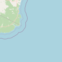
Point Hicks Marine National Park Boundary Map and Spatial Extent
Interactive boundary mapping defines the spatial extent and protected perimeter of the marine reserve. Associated metrics outline calculated area dimensions and geographic coordinate spans for spatial analysis.
- Boundary area
- 38 km²
- Boundary perimeter
- 29.2 km
- Northernmost point
- 37.7774° S
- Southernmost point
- 37.8503° S
- Easternmost point
- 149.2958° E
- Westernmost point
- 149.215° E
- Geographic centre
- 37.8127° S, 149.2537° E
- North–south span
- 8.1 km
- East–west span
- 7.1 km
Terrain and natural features
Explore recorded lowland classifications and maritime terrain features
Point Hicks Marine National Park Terrain and Named Natural Features
Stored lowland terrain classifications categorize the protected landscape alongside recorded named natural features located within the park boundaries. Linked feature cards supply official names, types, measurements, and spatial relationships for Whaleback Rock and Bass Strait.
Selected named natural features
Straits
Bass Strait
Environmental setting
Temperate marine waters and coastal lowland terrain characteristics
Point Hicks Marine National Park Environmental Classifications and Setting
Recorded marine habitats, temperate climate zones, and dominant water features provide structured categories for reading the physical setting of Point Hicks Marine National Park. Associated atlas entries link each environmental classification directly to related protected areas.
- Relief
- Lowland
- Climate
- Temperate
- Water
- Water-dominated
Landscape features
Coast
Habitat types
Marine habitat
Park atlas
Trace the regional protected-area geography and compare diverse marine and terrestrial landscapes around Victoria's eastern coast.
Explore Nearby Marine and Coastal Protected Areas Around Point Hicks Marine National Park
Beyond Point Hicks Marine National Park, browse other coastal and marine protected areas, tracing the geographical spread of conservation landscapes across Victoria's eastern region. Compare diverse park features, specific marine ecosystems, and adjacent terrestrial zones to understand the broader protected-area geography of Australia's southeastern coastline.
National parkAustralia
Park boundaries overlap#1 closest
Northeast

Croajingolong National Park: A UNESCO World Biosphere Reserve with Dramatic Coastal Geography
Explore Victoria's protected wilderness, mapped coastlines, and diverse ecosystems.
Croajingolong National Park is a key protected area in Victoria, Australia, recognized globally as a UNESCO World Biosphere Reserve. This vast national park offers a detailed look at coastal wilderness, characterized by its extensive sandy beaches, rugged rocky headlands, dynamic dunes, and rich heathland ecosystems. Its position along the Tasman Sea coastline provides significant geographic context, forming a vital part of southeastern Australia's protected landscapes and offering unique opportunities for atlas-driven exploration of its mapped terrain and biodiversity.
- Area
- 883.55 km²
- Established
- 1979
- IUCN
- II
- Relief
- Mixed relief
National parkAustralia
22 km away#2 closest
North
Alfred National Park: Southernmost Warm Temperate Rainforest Atlas and Protected Landscape
Explore a unique biogeographic boundary and diverse rainforest ecosystem.
Alfred National Park stands as a vital protected area, renowned for harboring Australia's southernmost warm temperate rainforest. Located in Victoria's East Gippsland region, this national park is a significant ecological meeting point, where plant communities from subtropical, temperate, and arid zones converge. The park's mapped landscape features a dense, jungle-like environment dominated by Lilly Pilly, tree ferns, and epiphytes, offering a distinct contrast to the typical eucalyptus woodlands of the area and highlighting its unique floristic character.
- Area
- 30.5 km²
- Established
- 1925
- IUCN
- II
- Climate
- Temperate
National parkAustralia
29 km away#3 closest
Northwest
Lind National Park: Historic Protected Landscape in East Gippsland, Victoria
Explore mapped boundaries and forested terrain within this early national park.
Lind National Park, established in 1925, is a key protected area in Victoria, Australia, preserving the characteristic forested landscapes of East Gippsland. Spanning 1,370 hectares, it offers a tangible connection to the state's early conservation efforts. The park's terrain is defined by temperate forest, characteristic of eastern Victoria's undulating geography, providing a clear example of protected woodland adjacent to the Princes Highway corridor. Its historical designation underscores its importance in the region's network of natural reserves and mapped landscapes.
- Area
- 13.7 km²
- Established
- 1925
- IUCN
- II
- Visitors
- 3.5K annual
National parkAustralia
34 km away#4 closest
North
Coopracambra National Park: Remote Mountainous Protected Landscape in Victoria
Explore its transboundary wilderness role and tall forest terrain.
Coopracambra National Park stands as a significant protected landscape in Victoria, Australia, renowned for its rugged mountainous terrain and extensive tall eucalypt forests. This remote national park serves as the crucial Victorian component of a vast transboundary wilderness corridor, linking protected areas across the state border into New South Wales. Its geographic identity is shaped by prominent peaks such as Mount Coopracambra and the unique Black-Allan Line boundary, offering users a detailed atlas view of its conservation significance and natural features within south-eastern Australia.
- Area
- 388 km²
- Established
- 1988
- IUCN
- II
- Relief
- Mountain
National parkAustralia
42 km away#5 closest
Northwest
Errinundra National Park: Australia's National Park Geographic Identity and Mapped Boundaries
Explore the protected landscape and natural terrain of this Australian national park.
Errinundra National Park offers a unique window into Australia's protected natural areas. This detailed view focuses on its role as a national park, providing structured information on its geographic footprint, mapped terrain, and position within the broader Australian landscape. Understand Errinundra National Park as a distinct entity for atlas-based discovery, focusing on its protected land characteristics and geographic context without visitor logistics.
- Area
- 268.75 km²
- Established
- 1988
- IUCN
- II
- Relief
- Upland
National parkNew South Wales
56 km away#6 closest
North
South East Forests National Park: New South Wales National Park Atlas Entry
Mapped landscape and protected area geography.
This canonical MoriAtlas entry for South East Forests National Park provides essential geographic context and details about its status as a national park. Understand the mapped boundaries of this protected landscape within New South Wales, supporting discovery through its regional setting and natural terrain. The focus remains on atlas-style exploration of its geographic identity and conservation significance, devoid of visitor logistics or travel advice.
- Area
- 1,151.77 km²
- Established
- 1997
- IUCN
- II
- Relief
- Highland
Marine protected areaAustralia
62 km away#7 closest
Northeast
Cape Howe Marine National Park: Victoria's Southeastern Marine Protected Landscape
Rugged coast, Southern Ocean influence, and marine conservation.
Cape Howe Marine National Park offers a protected marine environment at the remote eastern edge of Victoria, Australia. Defined by its dramatic coastal geography, the park features rocky headlands, exposed cliffs, and waters influenced by the powerful Southern Ocean. Established in 2002, this marine protected area contributes to a significant continuum of protected lands, adjacent to terrestrial national parks. Its landscape is shaped by powerful surf and coastal wilderness, providing a unique example of marine conservation where the Australian continent meets the open ocean.
- Area
- 40.5 km²
- Established
- 2002
- IUCN
- II
- Climate
- Temperate
National parkAustralia
71 km away#8 closest
Northwest
Snowy River National Park: A Deep Gorge Protected Landscape in Victoria, AU
Explore mapped terrain and vital alpine wilderness boundaries.
Snowy River National Park showcases Victoria's rugged natural geography with its dramatic mountain terrain and the spectacular Little River Gorge, the state's deepest. This national park, classified as a wilderness area for much of its expanse, protects critical habitats and diverse ecosystems across its mapped boundaries. Its significance as a protected landscape within the Australian Alps National Parks makes it a key destination for understanding regional geography and conservation efforts.
- Area
- 987 km²
- Established
- 1979
- IUCN
- II
- Relief
- Mountain
MoriAtlas Explorer
Continue Exploring the Mapped Geography of Point Hicks Marine National Park
Delve deeper into the protected landscape of Point Hicks Marine National Park by exploring its specific geographic features and marine protected area context. Understanding this area's unique role as a transitional zone provides valuable insight into Australia's coastal marine biodiversity and conservation. Continue your atlas exploration to uncover the intricate underwater terrain and the ecological significance of this protected marine environment.
Browse next
Global natural geography
Explore related park routes
Explore MoriAtlas Global ParksBrowse All MoriAtlas ParksGlobal Park Map DiscoveryMoriAtlas: Browse All CountriesBrowse All MoriAtlas ContinentsNational Park Environment AtlasGrand Canyon National Park AtlasYellowstone National Park AtlasYosemite National Park Atlas and GeographySerengeti National Park AtlasGalápagos National Park Protected LandscapeBanff National Park Geography and AtlasKruger National Park Atlas EntryUluṟu-Kata Tjuṯa National Park AtlasExplore Uluru-Kata Tjuta National Park GeographyPlitvice Lakes National Park AtlasFiordland National Park Protected LandscapeGreat Smoky Mountains National Park AtlasAfghanistan National Parks and Protected AreasAlbania National Parks and Protected AreasAlgeria National Parks and Protected AreasAmerican Samoa National Parks and Protected AreasAndorra National Parks and Protected AreasAngola National Parks and Protected AreasAntarctica National Parks and Protected AreasAntigua and Barbuda Park List