Lakes
Saif-ul-Maluk Lake
3,224 m

Structured landscape analysis including regional administrative scope and physical elevations.
Examine the detailed geographic characteristics of Saiful Muluk National Park, situated in the Mansehra District of Khyber Pakhtunkhwa, Pakistan. This profile covers the 880 square kilometer protected area, featuring high-altitude mountain terrain, lake ecosystems, and coniferous forests, with peak elevations reaching 3272 meters.
Related tags
Alpine lake sanctuary in the Kaghan Valley
Saiful Muluk National Park is a protected mountain wilderness area in the Kaghan Valley of Khyber Pakhtunkhwa, Pakistan. Established in 2003, the park encompasses approximately 880 square kilometers of alpine and subalpine terrain centred on the renowned Saiful Muluk Lake, a high-altitude glacial lake situated at an elevation of roughly 3,272 meters. The park lies within the Mansehra District, with the nearby town of Balakot serving as the closest urban centre. The landscape features dramatic Himalayan topography including steep valley walls, alpine meadows, and crystalline lake waters set against snow-capped peaks. The protected area forms part of a larger ecological corridor adjacent to Lulusar-Dudipatsar National Park, and together these parks preserve some 88,000 hectares of montane wilderness in the region.
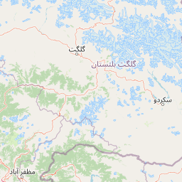
Regional placement within Khyber Pakhtunkhwa and Mansehra District
Interactive boundary geometry and calculated area metrics
Mountain relief metrics paired with recorded internal natural features
Lakes
3,224 m
Peaks
5,290 m
Interpreting stored mountain terrain, forest cover, and water systems
Mountains · Valleys · Lakes · Wetland
Temperate coniferous forest · Montane forest · Alpine meadow · Wetland · Riverine habitat
Trace the regional spread of protected landscapes and compare adjacent mountain wilderness areas in Khyber Pakhtunkhwa.
South

Explore mapped terrain and mountain biodiversity.
Machiara National Park, located in Azad Jammu and Kashmir, Pakistan, is a designated national park preserving unique Himalayan ecosystems. This atlas-focused exploration details the park's protected landscape, encompassing steep slopes, forested ridges, and varied terrain. Discover its significance for wildlife conservation and its position within the broader regional geography, offering a clear view of its mapped natural features.
Northeast
Explore alpine lakes, mountain scenery, and protected landscape geography.
Lulusar-Dudipatsar National Park stands as a remarkable protected landscape within Pakistan's Western Himalayas. The park's geography is defined by towering peaks and a series of pristine glacial lakes, including the iconic Dudipatsar and Lulusar lakes. Users can explore its mapped terrain and understand its significance as a high-altitude ecosystem and a key component of Pakistan's protected areas network.
East
Explore mapped boundaries and regional geography in Azad Kashmir.
Ghamot National Park represents a cornerstone for protected area exploration in Pakistan, situated within the dramatic mountainous terrain of Azad Kashmir. As a national park, it is recognized for its critical function as a wildlife corridor, especially for the survival of the Himalayan Brown Bear, and harbors diverse avian populations. This page offers detailed insight into its geographic context and its significance within a broader regional conservation strategy, providing rich data for atlas-based discovery.
South

Explore the regional landscape and terrain of this national park.
Kazinag National Park represents a distinct protected area within India's Baramulla district. This entry provides structured geographic information, focusing on the park's mapped boundaries and its role as a national park. Users can explore its landscape context and understand its specific regional terrain, contributing to a comprehensive atlas view of protected lands.
Northeast
Explore mapped boundaries and alpine terrain in Gilgit-Baltistan.
Nanga Parbat National Park is a vast protected area defined by its spectacular Himalayan setting and dramatic alpine geography within Gilgit-Baltistan, Pakistan. As a national park, it safeguards the immense Nanga Parbat massif, its surrounding glaciers, and diverse altitudinal landscapes. This page offers an atlas perspective for understanding the park's geographic scope, its mapped natural features, and its significance as a protected mountain wilderness.
South
Discover mapped terrain and protected area geography.
Panjal Mastan National Park represents a significant protected landscape within the Pir Panjal mountain range of Azad Kashmir, Pakistan. This national park is characterized by its expansive high-altitude plateau, sitting at an average elevation of 2,800 meters, offering a unique regional geography. Known for its dramatic mountainous surroundings and seasonal wildflower meadows that bloom in spring, the park provides valuable context for understanding the natural terrain and protected area distribution in this part of the western Himalayas.
Southeast
Tectonic freshwater lake and Ramsar-recognized protected area.
Wular Lake stands as one of the largest freshwater bodies in South Asia, characterized by its tectonic origin and its role as a critical component of the Jhelum River catchment. The protected nature reserve landscape currently encompasses a mosaic of open water, reed beds, and muddy shallows that provide habitat for endemic snowtrout and migratory bird populations throughout the Kashmir Valley.
East
Explore its mapped terrain and regional geographic context.
Gurez National Park stands as a protected national park within Pakistan's breathtaking Himalayan mountain system. This park is crucial for conserving the endangered musk deer and safeguarding a fragile alpine ecosystem characterized by dramatic valleys, steep peaks, and the flowing Kishenganga River. Its relative isolation preserves a unique natural landscape and traditional cultural heritage, making it a point of interest for understanding remote wilderness and conservation efforts within the South Asian atlas.
Deepen your understanding of Saiful Muluk National Park by exploring its specific geographic context and protected area mapping. Discover the unique alpine terrain and regional landscape characteristics that define this important national park in Khyber Pakhtunkhwa. Continued exploration offers insight into its ecological significance and its place within the broader Himalayan atlas.