Mori Atlas logo
National parkSmolenskoye Poozerye National Park

Detailed mapping and regional geographic context for Smolenskoye Poozerye National Park.

Smolenskoye Poozerye National Park: National Park Protected Landscape in Smolensk Oblast

Smolenskoye Poozerye National Park stands as a significant protected landscape within the Smolensk Oblast region of Russia. This page offers an atlas-centric view, detailing the park's mapped boundaries and its placement within the broader geographic context of Central Russia. Explore the protected area's identity and its role in the regional landscape through structured data and map-based discovery tools.

National parksForest ecosystemsGlacial lakesWetlandsBiosphere reservesEastern Europe

Smolenskoye Poozerye National Park

National park

Park overview

Structured park overview, official facts, and landscape profile for Smolenskoye Poozerye National Park

Smolenskoye Poozerye National Park park facts, protected area profile, and essential visitor context
Review the core facts for Smolenskoye Poozerye National Park, including designation, size, terrain, visitor scale, habitats, and operating context in one park-focused overview.

About Smolenskoye Poozerye National Park

Smolenskoye Poozerye National Park protects one of Russia's most important forest-wetland ecosystems in the western part of the country. The park lies in a glacially formed landscape of lakes and river valleys where the Western Dvina River system has carved a network of interconnected water bodies across a relatively flat terrain. The approximately 35 lakes range in size, with Lake Sapsho being the largest at 3 square kilometers and serving as the primary tourist destination. The surrounding forests are a mix of coniferous species such as spruce and pine along with broadleaf species dominated by birch and aspen, creating the characteristic Sarmatic mixed forest that stretches from the Baltic region eastward toward the Ural Mountains. Boglands occupy a significant portion of the park, representing crucial wetland habitats that support specialized flora and fauna. The park is administratively divided between Demidovsky and Dukhovshchinsky Districts of Smolensk Oblast and functions both as a conservation area and as a recreation destination for residents of nearby cities. The protected area was established in 1992 following years of scientific study and advocacy for preserving this distinctive corner of western Russian nature.

Quick facts and research context for Smolenskoye Poozerye National Park

Smolenskoye Poozerye spans roughly 55 kilometers east-west and 50 kilometers north-south across a flat lake district in Smolensk Oblast. The landscape ranges from 167 to 248 meters in elevation, characterized by glacial moraines, river floodplains, and a chain of glacial lakes dominated by Lake Sapsho. About 75 percent of the park is forested, with birch as the predominant tree species followed by spruce, pine, aspen, and black alder. The park supports significant biodiversity including 54 mammal species, 232 bird species, and 37 fish species. The area contains the resort town of Przhevalskoye on Lake Sapsho and receives approximately 250,000 visitors annually, primarily from the local region.

Park context

Deeper park guide and search-rich context for Smolenskoye Poozerye National Park

Smolenskoye Poozerye National Park history, landscape, wildlife, and travel context
Explore Smolenskoye Poozerye National Park through its history, landscape character, ecosystems, wildlife, conservation priorities, cultural context, and seasonal travel timing in a structured park guide built for atlas discovery and search intent.

Why Smolenskoye Poozerye National Park stands out

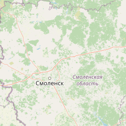
Smolenskoye Poozerye is best known for its exceptional chain of 35 glacial lakes set within a pristine forest-wetland complex near the Russian-Belarusian border. The park's signature landscape is the Lake Sapsho area with its resort town of Przhevalskoye, which serves as the main recreational hub. The combination of extensive bogs, meandering rivers, and mixed forests creates a distinctive lacustrine ecosystem that is relatively rare in European Russia. The park's inclusion in the UNESCO-supported biosphere reserve network since 2002 reflects its significance as a model of integrated conservation and sustainable land use in the Sarmatic forest zone.

Blue informational signboard with map and details of Lake Sapsho in Smolenskoye Poozerye National Park
Informational signboard showing map and details of Lake Sapsho in Smolenskoye Poozerye National Park

Smolenskoye Poozerye National Park history and protected-area timeline

The territory of Smolenskoye Poozerye has been inhabited since ancient times, with archaeological evidence scattered throughout the park demonstrating continuous human presence over millennia. The earliest evidence includes flint tools from the Mesolithic period, dating to approximately 7,000 to 8,000 BCE, representing some of the oldest human artifacts found in the region. Seventeen known Neolithic sites have been documented within the park boundaries, along with approximately 25 Bronze Age memorial sites, indicating that the lake district supported significant prehistoric communities. From the fifth century CE onward, the area developed within the Slavic cultural sphere, with agricultural and timber-based economies shaping the landscape. In modern times, researchers have documented 123 villages within the broader region, many of which predate the park's formal establishment. The park was officially created in 1992 to protect this ecologically and historically significant landscape, and in 2002 it was admitted to the international network of biosphere reserves under the Man and the Biosphere Programme, recognizing its dual role in conservation and sustainable development.

Smolenskoye Poozerye National Park landscape and geographic character

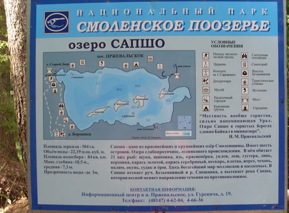
The physical landscape of Smolenskoye Poozerye is defined by its glaciated terrain of low ridges, flat floodplains, and interconnected lakes formed during the retreat of the last ice sheet. The park covers a roughly rectangular area measuring approximately 55 kilometers from east to west and 50 kilometers from north to south. Elevations within the park range from 167 meters in the lowest river valleys to 248 meters at the highest points, creating a gently undulating terrain without dramatic relief. The underlying geology features gravel moraines and glacial deposits that create a hummocky surface topology. Two main rivers, the Yelsha and the Polovya, traverse the park and connect the lake system to the broader Western Dvina watershed. The largest water body, Lake Sapsho, covers 3 square kilometers and occupies a glacial kettle basin. The landscape includes approximately 16,240 hectares of bogs, 1,608 hectares of lakes, and 468 hectares of rivers, with the remaining area consisting primarily of forested land.

Smolenskoye Poozerye National Park ecosystems, habitats, and plant life

The ecological character of Smolenskoye Poozerye reflects its position within the Sarmatic mixed forests ecoregion, a zone of coniferous and deciduous woodlands that extends from southern Sweden across the Baltic states and central eastern Europe to the Ural Mountains. The park encompasses a remarkable diversity of habitats in a relatively compact area, including pine forests, spruce forests, broadleaf forests, extensive bogs, sedge meadows along water bodies, dry meadows, and aquatic habitats. Tree species composition is dominated by birch at approximately 38 percent of forest cover, with spruce at 16 percent, pine at 12 percent, aspen at 13 percent, and black alder at 6 percent. This mix of coniferous and deciduous species creates a structurally complex forest that provides varied habitats for wildlife. The extensive bog systems represent particularly important wetland habitats within the forest matrix, supporting specialized plant communities adapted to acidic, nutrient-poor conditions.

Smolenskoye Poozerye National Park wildlife and species highlights

Smolenskoye Poozerye supports a diverse animal community across its forest, wetland, and aquatic habitats. Biological surveys have documented 54 species of mammals, 232 species of birds, and 37 species of fish within the park boundaries. The combination of old-growth forests, wetlands, and lakes creates habitat conditions suitable for a wide range of species, from large mammals like moose and wild boar to numerous waterfowl and songbirds. The extensive wetland systems are particularly important for migratory birds, and in 2012 the World Wildlife Fund initiated a dedicated conservation project focused on rare bird species in the large wetland complexes of the Smolensk Lakeland. The lake environments support fish populations that are characteristic of the Volga-Ural freshwater ecoregion, a region noted for its relatively high fish species diversity despite limited endemism.

Smolenskoye Poozerye National Park conservation status and protection priorities

Smolenskoye Poozerye holds significant conservation value as a protected area within the Sarmatic mixed forests ecoregion, a biome that has faced substantial pressure from agriculture and forestry across its range. The park's inclusion in the international biosphere reserve network since 2002 reflects recognition of its importance both as a biodiversity conservation site and as a model for sustainable human-nature coexistence in this part of Russia. The protected area preserves representative examples of the forest-wetland ecosystems that once covered much of western Russia but have been heavily modified by human activity. The park's network of lakes, rivers, and bogs maintains important ecological processes including water filtration, carbon storage, and wildlife habitat provision. Conservation challenges include balancing visitor access with habitat protection and managing the interface between protected lands and the surrounding agricultural landscape.

Smolenskoye Poozerye National Park cultural meaning and human context

The Smolensk Lakes region carries deep historical significance as one of the oldest continuously inhabited areas in western Russia. The archaeological record within the park documents human presence spanning from the Mesolithic period through the Neolithic and Bronze Age, with Slavic agricultural settlement beginning in the fifth century CE. This long history of occupation has produced a cultural landscape where natural and historical elements are intertwined. The park contains the resort town of Przhevalskoye on the shores of Lake Sapsho, which serves as the primary visitor accommodation and recreational hub. Traditional land uses including agriculture, forestry, and fishing have shaped both the natural environment and the cultural character of the region. The park maintains cultural heritage sites and offers educational programs that connect visitors to the historical significance of the area.

Top sights and standout views in Smolenskoye Poozerye National Park

The defining feature of Smolenskoye Poozerye is its exceptional chain of glacial lakes surrounded by forest and wetland, creating a landscape of outstanding natural beauty within western Russia. Lake Sapsho and its resort town of Przhevalskoye serve as the park's main attraction, offering visitors access to boating, fishing, and recreational activities in a scenic lakeside setting. The extensive network of nature trails, including a family-friendly route themed around Russian forest folklore, provides opportunities for exploring the park's diverse habitats. Birdwatching programs and guided tours to historical-cultural sites add to the visitor experience. The park's biosphere reserve status and its role in preserving representative Sarmatic forest ecosystems give it significance beyond its local context, making it a model for integrated conservation in the region.

Best time to visit Smolenskoye Poozerye National Park

Smolenskoye Poozerye experiences a humid continental climate with warm summers and cold, snowy winters typical of the western Russian interior. The summer months from June through August offer the most comfortable conditions for outdoor activities, with average temperatures reaching into the low 20s Celsius and the landscape fully green with long daylight hours. The park's wetland and lake environments are particularly appealing during the warmer months when water-based recreation is possible and wildlife viewing opportunities are at their best. Winter visitation is possible but limited by snow cover and cold temperatures that can drop well below freezing, with the park's flat terrain becoming less accessible for general tourism. Spring and autumn provide transitional seasons with their own character, though spring flooding may affect trail accessibility and autumn conditions can be variable. The park operates year-round, though the majority of its approximately 250,000 annual visitors arrive during the summer peak season.

Park location guide

Geography guide, regional context, and park location map for Smolenskoye Poozerye National Park

Smolenskoye Poozerye National Park park geography, regions, and map view in Russia
Understand where Smolenskoye Poozerye National Park sits in Russia through a broader geographic reading of the surrounding landscape, nearby location context, and its mapped position within the national park landscape.

How Smolenskoye Poozerye National Park fits into Russia

Russia is a transcontinental nation spanning eleven time zones, bordered by fourteen countries. It is the world's largest country by area, covering 17,098,246 km². Moscow is the capital and largest city, while Saint Petersburg is the second-largest and a major cultural centre.

Wider geography shaping Smolenskoye Poozerye National Park in Russia

Russia spans Eastern Europe and North Asia, covering 17,098,246 km². It shares land borders with fourteen countries, more than any other nation, and spans eleven time zones. The landscape includes vast plains, mountain ranges such as the Urals and Caucasus, and extensive coastlines along the Arctic Ocean, Pacific Ocean, Baltic Sea, Black Sea, and Caspian Sea.

Map view of Smolenskoye Poozerye National Park

Use this park location map to pinpoint Smolenskoye Poozerye National Park in Russia, understand its exact geographic position, and read its mapped placement within the surrounding landscape more clearly.

Pigeon | © OpenStreetMap contributors

Location context for Smolenskoye Poozerye National Park

Smolensk Oblast

Explore the distinctive blend of glacial lakes, dense forests, and extensive wetlands that define Smolenskoye Poozerye's protected environment.

Smolenskoye Poozerye National Park: Visualizing Glacial Lake Landscapes and Forest Scenery
Visually explore Smolenskoye Poozerye National Park through comprehensive imagery showcasing its unique glacial lakes, extensive forest ecosystems, and characteristic wetland habitats. These views reveal the park's undulating glaciated terrain and the intricate connections between its diverse natural features.

Blue informational signboard with map and details of Lake Sapsho in Smolenskoye Poozerye National Park

A wide view of Lake Sapsho showing forested islands surrounded by calm water with trees in the foreground and a cloudy sky

Park atlas

Trace the network of glacial lakes and forest-wetland protected areas across Western Russia

Compare National Parks and Protected Areas Near Smolenskoye Poozerye National Park
Browse other national parks and protected areas across western Russia, extending your discovery beyond Smolenskoye Poozerye National Park into similar glacial lake and forest-wetland ecosystems. Use this geographic context to compare diverse protected landscapes, trace regional conservation efforts, and understand the ecological spread of glaciated terrain in Eastern Europe.
Watercolor painting of a lake with green forested islands and distant mountains under a pastel sky
National parkPskov Oblast

Sebezhsky National Park: National Park within Pskov Oblast's Regional Geography

Mapped protected landscape and regional context

Sebezhsky National Park is a designated national park offering a distinct protected landscape within the Pskov Oblast of northwestern Russia. This page provides essential details for atlas exploration, focusing on the park's mapped boundaries, its role as a protected area, and its contribution to the regional geography of the Pskov Oblast. Users can understand its place within a broader mapping of Russia's natural territories and protected lands.

Area
500.21 km²
Established
1996
IUCN
II
Relief
Highland
Watercolor illustration showing a lake, trees, and distant hills
National parkLatgale

Rāzna National Park: Protected Landscape and Regional Geography in Latgale

Explore the mapped terrain of Latvia's largest lake region.

Rāzna National Park, situated in the Latgale region, provides an essential focal point for understanding eastern Latvia's protected landscapes. This national park, recognized for its extensive glacial terrain and the significant Lake Rāzna, offers a distinct geographic profile. Users can explore its mapped boundaries, discover its role as a vital protected area, and understand its landscape context within the broader atlas of Latvia's natural heritage.

Area
596.14 km²
Established
2007
IUCN
II
Relief
Highland
National park

Braslaw Lakes National Park: Protected Glacial Lake Landscape Atlas

Mapped boundaries and terrain of a key Belarusian protected area.

Braslaw Lakes National Park presents a fascinating protected landscape defined by its extensive glacial lake chain, lush forests, and vital wetland ecosystems. As a significant natural region in northern Belarus, it offers valuable insights into lacustrine environments and glacially formed terrain. This park serves as a prime example of protected land within the Vitebsk Region, ideal for exploring its mapped geography, understanding its ecological importance, and appreciating the unique character of Eastern Europe's lake districts through a structured atlas lens.

Watercolor illustration of a lake with green forests and grassy foreground, distant hills, and purple and orange water tones
National park

Valdaysky National Park: Russia's National Park & Protected Landscape Explorer

Discover its mapped boundaries and regional geographic context.

Valdaysky National Park represents a significant protected area, offering a focused entry into Russia's natural landscapes. This MoriAtlas page provides detailed geographic context, mapping the park's protected boundaries and its position within the regional terrain. Use this resource to understand the park's unique landscape identity and its value for structured atlas-based discovery of protected lands.

Area
1,585 km²
Established
1990
IUCN
II
Visitors
60K annual
National parkMinsk Region

Narachanski National Park: Belarus's Premier National Park and Lake District Atlas

Explore protected glacial terrain and diverse lake systems.

Narachanski National Park is the crown jewel of Belarus's lake district, a protected national park safeguarding a landscape defined by glacial origins and extensive freshwater systems. Centered around Lake Narach, the park's territory within Minsk Region showcases a varied terrain of moraine hills, depressions, and over 30 lakes. This atlas perspective highlights the park's unique geological features, extensive forests, and its role as a vital protected area for understanding regional geography.

Area
933 km²
Established
1999
IUCN
II
Relief
Lowland
Watercolor illustration of a lake surrounded by forests and mountains under a light sky
National parkTver Oblast

Zavidovo National Park: Exploring its Protected Landscape and Geographic Identity

Mapped protected areas within Tver Oblast's regional geography.

Delve into the specifics of Zavidovo National Park, a designated national park situated within the Tver Oblast. This detailed page provides a geographic lens, allowing for exploration of its protected landscape, mapped boundaries, and its regional context. Understand how this protected area contributes to the larger atlas of Russia's natural environments and discover its unique geographic features through structured, searchable data.

Area
1,329 km²
Established
2015
IUCN
II
Relief
Lowland
National park

Aukštaitija National Park: Lithuania's Oldest National Park and Protected Landscape Exploration

Mapped geography and lake district atlas for this Baltic region park.

Delve into Aukštaitija National Park, Lithuania's pioneering national park and a key protected area in the Baltic region. This detailed atlas entry highlights its defining geography: an extensive mosaic of over 120 lakes interwoven with ancient pine forests across undulating highlands. Understand the park's protected landscape, its mapped boundaries, and its ecological significance within Eastern Europe's natural terrain.

Area
410.56 km²
Established
1974
IUCN
II
Relief
Upland
National park

Ugra National Park: Explore Russia's Protected Landscape and National Park Atlas

Mapped boundaries and regional geographic context.

Ugra National Park represents a crucial protected area within Russia, offering detailed geographic context for atlas-based exploration. This entry details the park's specific identity as a national park, highlighting its mapped boundaries and landscape character. Engage with the structured data to understand Ugra National Park's position within Russia's geography and its significance as a protected natural landscape, facilitating comprehensive map exploration.

Area
986,245 km²
Established
1997
IUCN
II
Relief
Lowland

Common questions about visiting, size, designation, and location context for Smolenskoye Poozerye National Park

Smolenskoye Poozerye National Park FAQs for park facts, access, geography, and protected area context
Find quick answers about Smolenskoye Poozerye National Park, including protected-area facts, park geography, trail and visitor context, and how the park fits into its surrounding country and regional landscape.
MoriAtlas Explorer

Continue Your Protected Areas Search Across the Global Atlas

Deepen your exploration by continuing the structured search for national parks and protected areas worldwide. Utilize the comprehensive filtering capabilities to compare different conservation landscapes and refine your understanding of global park geography. Discover more about the distribution and characteristics of protected natural areas.

Global natural geography