Peaks
Mount Mambup
224 m

Technical landscape insights, boundary data, and recorded natural feature distributions
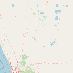
Examine the detailed physical characteristics of Walyunga National Park, a protected area within Western Australia encompassing 18.14 square kilometers of diverse terrain. This geographic profile details the park's defined boundaries, river systems including the Swan and Avon, and inland natural features like Mount Mambup and Walyunga Lookout.
Related tags
A 6,000-year-old Noongar meeting place nestled in the Darling Range near Perth
Walyunga National Park is a protected area in Western Australia situated approximately 35 kilometers northeast of Perth along the Great Northern Highway. The park occupies a steeply sided valley in the Darling Range just behind the Darling Scarp, featuring a landscape dominated by dramatic granite outcrops with smaller dolerite areas and laterite-capped hilltops. The Swan-Avon River flows through the park, creating the Walyunga Pool area just downstream from where the Avon River transitions into the Swan River. The Eastern Railway also passes through the park, adding historical significance to the natural landscape. Established in 1970 and managed by the Department of Environment and Conservation, the park holds IUCN Category II protection status. The area carries deep cultural significance as a 6,000-year-old meeting place for the Noongar people, with the name Walyunga roughly translating to "Happy Place."
Administrative and regional location data within Australia
Interactive protected boundary geometry and derived area measurements
Mixed relief classification and recorded natural features within the park geography
Peaks
224 m
Streams
Viewpoints
Peaks
Rivers
Rivers
Temperate broadleaf forest, Mediterranean climate zones, and mixed valley relief
Valleys · Cliffs · Forest
Temperate broadleaf forest
Browse adjacent protected areas and compare their diverse landscapes throughout the Darling Range region of Western Australia.
Northeast

Explore mapped boundaries and regional landscape context.
Delve into Avon Valley National Park, a designated national park offering rich opportunities for protected-area and landscape discovery. This page serves as an atlas-style entry point, detailing the park's mapped geography and its role within the diverse natural terrain of Western Australia. Understand its specific protected landscape identity and how it contributes to the broader conservation map.
South
Mapped boundaries and regional geographic context.
Delve into the atlas-level details of John Forrest National Park, a protected area situated in Western Australia. This park's designation as a national park provides a focal point for understanding its specific geographic features and mapped extent. Users can explore its place within the broader regional geography of Western Australia, gaining structured insight into the protected landscape.
Southeast
Mapped landscapes and mammal recovery in the Darling Scarp.
Located in the Darling Scarp of Western Australia, Karakamia Sanctuary is a protected wildlife reserve defined by its lateritic plateau and jarrah forest ecosystems. This reserve provides a critical refuge for species recovery through predator exclusion and habitat management, offering a clear window into the ecological restoration of the region.
South
Explore its protected boundaries and regional landscape context.
Greenmount National Park represents a distinct protected landscape within the diverse geography of Western Australia. As a National Park, its mapped boundaries are integral to understanding its regional context and offering users a point of detailed geographic discovery. This entry provides essential data on its protected status and geographic setting, supporting exploration of Australia's significant natural areas through an atlas-driven lens.
South
Mapped Geographic Context & Natural Terrain Discovery
Beelu National Park, situated in Western Australia's Darling Range, offers an immersive experience within old-growth jarrah-marri forests. This protected area provides a vital glimpse into the region's natural landscapes, characterized by rolling hills and the Helena River valley. Users can explore the park's geographic setting, its mapped boundaries, and the unique ecological context it preserves. It stands as a significant natural reserve contributing to the understanding of Western Australia's conservation efforts and diverse terrain.
South
Explore mapped boundaries and regional park context.
Gooseberry Hill National Park is a significant protected area designated as a national park within the diverse geography of Western Australia. This entry provides detailed insights into its specific location, mapped boundaries, and role as a conservation landscape. Understand how Gooseberry Hill National Park contributes to the broader atlas of protected lands in Western Australia, offering a foundational view for geographic exploration and landscape context.
South
A protected national park with distinct mapped landscape features.
Kalamunda National Park is an essential protected area located on the western slopes of the Darling Scarp, offering a clear representation of southwestern Australia's characteristic eucalypt woodland ecosystems. Its geography is defined by the escarpment's terrain, supporting tall marri, jarrah, and wandoo forests with a diverse understorey. As a national park, it provides critical habitat and contributes to the regional landscape context within Western Australia, making it a valuable point for atlas-driven discovery of protected natural areas.
South
Mapped natural terrain and regional geographic context
Lesmurdie Falls National Park stands as a protected natural landscape within the extensive geography of Western Australia. This dedicated national park offers a focused point for exploring mapped terrain and understanding regional conservation areas. Through MoriAtlas, users can delve into the specific geographic features and protected boundaries that define Lesmurdie Falls National Park, contributing to a comprehensive atlas-based understanding of Australia's natural landscapes.
Delve deeper into Walyunga National Park to understand its specific geographic context and its significance as a protected national park within Western Australia. This detailed exploration allows for a richer appreciation of its mapped natural landscape and its place in the regional atlas of conservation areas, offering structured data for geographic discovery.