Mori Atlas logo
National parkBattle of Sakarya National Historic Park

Navigate the strategic terrain and historic mapped boundaries of this significant national park.

Battle of Sakarya National Historic Park: Preserving a Pivotal Battlefield in Ankara's Geography

Battle of Sakarya National Historic Park stands as a testament to a decisive moment in Turkish history, preserving the very ground where the pivotal Battle of Sakarya was fought in 1921. Situated within the undulating landscapes near Ankara, this national park offers a unique opportunity for geographic and historical exploration. Discover the strategic importance of its hilly terrain, mapped defensive positions, and the enduring legacy of the Turkish War of Independence through detailed atlas-style context.

Historic BattlefieldTurkish War of IndependenceNational Historic ParkMemorial SiteCultural HeritageMilitary History

Battle of Sakarya National Historic Park

National park

Park overview

Structured park overview, official facts, and landscape profile for Battle of Sakarya National Historic Park

Battle of Sakarya National Historic Park park facts, protected area profile, and essential visitor context
Review the core facts for Battle of Sakarya National Historic Park, including designation, size, terrain, visitor scale, habitats, and operating context in one park-focused overview.

About Battle of Sakarya National Historic Park

Battle of Sakarya National Historic Park preserves the physical landscape of one of the defining moments in Turkish national history. The Battle of Sakarya, fought from late August to mid-September 1921, represented the climax of the Greco-Turkish War and the most extensive military operation of the Turkish War of Independence. The battle unfolded across undulating terrain characterized by a series of hills and ridgelines that provided strategic advantage to defending forces. Turkish command, under Mustafa Kemal Atatürk, successfully coordinated defensive operations that exhausted and ultimately repelled the Greek advance, despite facing numerically superior forces. The establishment of the national historic park in 2015 formalizes protection for this significant historical landscape, ensuring that future generations can access and understand the terrain where the outcome of the independence struggle was determined. The park encompasses multiple named positions including Mangal Dağı, Duatepe, and Yıldız Dağı, each representing locations where particular phases of the battle unfolded. Ongoing preparation work continues to document and preserve the historical features within the park boundaries.

Quick facts and research context for Battle of Sakarya National Historic Park

This historic park covers approximately 13,850 hectares in Ankara Province, established in February 2015 to preserve the battlefield of the Battle of Sakarya. The battle, fought between August and September 1921, was the largest and most significant engagement of the Turkish War of Independence. The park spans the districts of Polatlı and Haymana, encompassing key tactical positions including Mangal Dağı, Türbe Tepe, Yıldız Dağı, Duatepe, Karatepe, Kartaltepe, and Sarıçal Dağı. Managed by Turkey's Ministry of Forest and Water Management, the site serves as both a memorial to those who fought and an educational resource for understanding this formative period in Turkish history.

Park context

Deeper park guide and search-rich context for Battle of Sakarya National Historic Park

Battle of Sakarya National Historic Park history, landscape, wildlife, and travel context
Explore Battle of Sakarya National Historic Park through its history, landscape character, ecosystems, wildlife, conservation priorities, cultural context, and seasonal travel timing in a structured park guide built for atlas discovery and search intent.

Why Battle of Sakarya National Historic Park stands out

The park is best known as the preserved battlefield of the Battle of Sakarya, the largest and most decisive engagement of the Turkish War of Independence. This 1921 battle halted the Greek offensive and shifted the strategic initiative to Turkish forces, making it a turning point in the conflict that led to the Treaty of Lausanne and Turkish independence. The hilly terrain around Polatlı and Haymana contains surviving trenches, positions, and memorial sites that provide tangible connection to one of the most significant military victories in modern Turkish history.

Bronze statue of a seated figure on a stone pedestal with a valley and hills in the background
Statue of Atatürk at Duatepe within Battle of Sakarya National Historic Park, overlooking the valley

Battle of Sakarya National Historic Park history and protected-area timeline

The Battle of Sakarya National Historic Park was officially established on February 8, 2015, through publication in the Official Gazette of Turkey. The creation of this protected area reflected decades of recognition that the Sakarya battlefield required formal preservation to maintain its historical integrity and public accessibility. The Battle of Sakarya itself, known in Turkish as Sakarya Meydan Muharebesi, had been fought in the same location in 1921 during the Greco-Turkish War, a phase of the broader Turkish War of Independence. The three-week engagement represented the last major offensive by Greek forces, which after initial successes had pushed deep into Anatolia. Turkish forces under Mustafa Kemal's command conducted a strategic defense that gradually wore down the advancing enemy while conserving their own strength for counteroffensive operations. Following the battle's conclusion, Greek forces retreated to new defensive lines, never again mounting such an ambitious offensive. The victory at Sakarya marked a turning point that enabled subsequent Turkish military operations leading to full independence. The establishment of the park as a Tarihi Milli Parkı, or National Historic Park, designates it as a protected area specifically for its historical significance rather than natural landscape value.

Battle of Sakarya National Historic Park landscape and geographic character

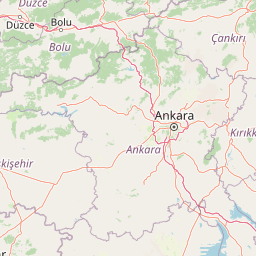
The park occupies a landscape of gently rolling hills and elevated terrain in central Anatolia, approximately 100 kilometers southwest of Ankara city. The terrain around Polatlı and Haymana consists of undulating plateaus and ridges that provided natural defensive advantages during the 1921 battle. The elevation changes across the battlefield area create a varied topography of hills, slopes, and valleys that influenced tactical decisions during the engagement. The surrounding region is characterized by the semi-arid central Anatolian steppe, with vegetation typical of this climatic zone. The landscape's physical features remain largely preserved, maintaining the strategic character of the terrain that made it suitable for the defensive operations that determined the battle's outcome. Key topographic features within the park include several named hills and peaks that served as strategic positions during the fighting.

Battle of Sakarya National Historic Park conservation status and protection priorities

The park is designated as a protected area under Turkey's national park system, specifically classified as a Tarihi Milli Parkı, or National Historic Park, recognizing its significance as a preserved historical landscape rather than a natural ecosystem. This designation ensures legal protection for the battlefield remains and historical features within the park boundaries. Conservation efforts focus on maintaining the physical integrity of the battleground, documenting surviving trench systems and positions, and preserving memorial structures. The status provides a framework for managing public access while protecting the historical and cultural values of the site. Ongoing work includes surveys and documentation of the various historical features scattered across the park's 13,850-hectare area.

Battle of Sakarya National Historic Park cultural meaning and human context

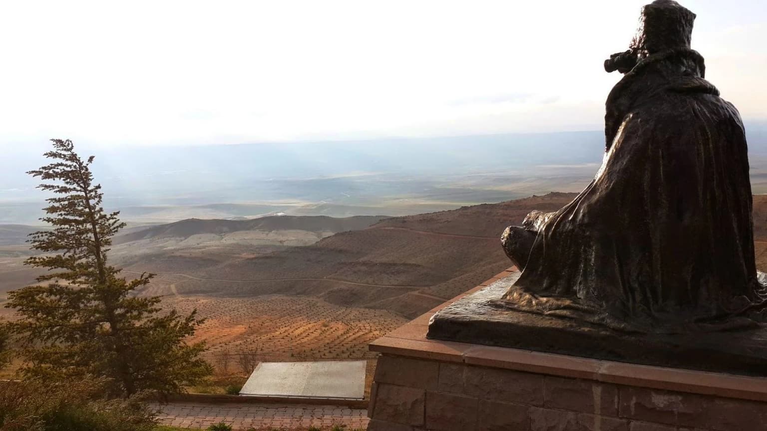
The Battle of Sakarya holds profound significance in Turkish national memory as the decisive moment when the Turkish War of Independence shifted decisively in favor of Turkish forces. The battle is taught as a foundational event in Turkish history, representing both military achievement and national unity during a period of existential threat. The site preserves physical evidence of the conflict that students and citizens can visit to connect directly with this formative period. The memorial areas within the park, including the martyrs' cemetery, serve as sites of remembrance and commemoration for those who fell during the engagement. The preservation of the battlefield allows for continued interpretation of how the terrain and circumstances shaped the battle's outcome and consequently influenced the political future of Anatolia and the Turkish nation.

Top sights and standout views in Battle of Sakarya National Historic Park

The park preserves the actual terrain where the largest battle of the Turkish War of Independence unfolded across three weeks in September 1921. Visitors can access the hills and positions where critical phases of the battle occurred, including Duatepe with its commanding views and memorial statue. The surviving trench systems and defensive positions provide tangible evidence of the conditions under which the engagement unfolded. The martyrs' memorial areas within the park serve as sites of commemoration for those who fought in the battle. The strategic landscape itself remains largely intact, allowing visitors to understand how the natural terrain influenced tactical decisions during the fighting.

Best time to visit Battle of Sakarya National Historic Park

The park can be visited year-round, though spring and autumn months offer the most comfortable conditions for exploring the outdoor battlefield terrain. Summer temperatures in central Anatolia can be quite high, making morning or late afternoon visits preferable. Winter visits are possible though the site is exposed and temperatures can drop significantly. The park's outdoor nature means that weather conditions will affect the experience, with clear days providing the best visibility across the battlefield terrain.

Park location guide

Geography guide, regional context, and park location map for Battle of Sakarya National Historic Park

Battle of Sakarya National Historic Park park geography, regions, and map view in Turkey
Understand where Battle of Sakarya National Historic Park sits in Turkey through a broader geographic reading of the surrounding landscape, nearby location context, and its mapped position within the national park landscape.

How Battle of Sakarya National Historic Park fits into Turkey

Turkey, officially the Republic of Türkiye, is a transcontinental country located mainly in Anatolia (West Asia) with a smaller portion in East Thrace (Southeast Europe). It borders the Black Sea to the north, several countries to the east and south, and the Aegean Sea and European countries to the west. The country has a population of over 86 million and operates as a secular, Muslim-majority presidential republic with Ankara as capital and Istanbul as its largest city.

Wider geography shaping Battle of Sakarya National Historic Park in Turkey

Turkey is a transcontinental country with the majority of its territory (about 97%) located in Anatolia (West Asia) and a smaller portion called East Thrace in Southeast Europe. It borders the Black Sea to the north, Georgia, Armenia, Azerbaijan, and Iran to the east, Iraq and Syria to the south, and the Mediterranean Sea to the southwest. To the west, Turkey borders the Aegean Sea, Greece, and Bulgaria. The terrain includes mountains, plateaus, and coastal plains, with the Taurus Mountains running along the southern coast.

Map view of Battle of Sakarya National Historic Park

Use this park location map to pinpoint Battle of Sakarya National Historic Park in Turkey, understand its exact geographic position, and read its mapped placement within the surrounding landscape more clearly.

Pigeon | © OpenStreetMap contributors

Location context for Battle of Sakarya National Historic Park

Ankara

Explore essential imagery showcasing the hilly Central Anatolian terrain, strategic positions, and preserved historic features of this pivotal protected area.

Battle of Sakarya National Historic Park Photos: Visualizing the Battlefield Landscapes and Protected Terrain
Browse images revealing the distinct landscapes of Battle of Sakarya National Historic Park, from its rolling hills to the semi-arid steppe and key topographic features that shaped the historic battleground. Visualizing this physical environment offers crucial context for understanding the park's unique protected-area character and its role in preserving a defining moment of national history.

Bronze statue of a seated figure on a stone pedestal with a valley and hills in the background

Large statue of a person standing on a hilltop with a clear blue sky background

Park atlas

Explore the protected landscapes of Central Anatolia, tracing park geography and conservation efforts around Ankara

Discover Nearby National Parks and Protected Areas near Battle of Sakarya National Historic Park
Explore additional national parks and protected areas situated near Battle of Sakarya National Historic Park, enabling further geographic discovery of Central Anatolia's diverse conservation landscapes. Browse mapped park geography and compare protected areas across the region, understanding their unique characteristics and regional context beyond this pivotal historic site.
Watercolor illustration of a forested landscape with green trees, rolling hills, and distant mountains
National parkTurkey

Soğuksu National Park: Turkey's Highland Forest Protected Landscape Discovery

Explore mapped boundaries and unique Anatolian geography.

Soğuksu National Park serves as a significant protected natural area in central Turkey, celebrated for its substantial coniferous forest ecosystem. This park showcases a transition zone between major geographic regions, offering a unique highland landscape shaped by volcanic geology. Discover its mapped protected boundaries and its role as a vital natural atlas point within the broader Turkish geography, featuring diverse terrain and important ecological elements.

Area
11.87 km²
Established
1959
IUCN
II
Relief
Mountain
National parkAnkara Province

Mount Sarıçalı National Park: Turkey's Newest Protected Mountain Landscape

Ancient forests, endemic botany, and dramatic mountain terrain.

Mount Sarıçalı National Park, located in Ankara Province, Turkey, is a testament to the nation's commitment to conservation. This protected area is celebrated for its ancient forests, with larch, Kasnak oak, and juniper trees dating back 700-800 years. Its position at the confluence of three phytogeographic zones supports a rich array of 139 endemic plant species. The park's landscape is further characterized by the striking Uyuzsuyu Waterfall and the imposing Mount Sarıçalı peak, offering a profound geographic context for atlas exploration.

Area
10.24 km²
Established
2021
IUCN
II
Relief
Mountain
Watercolor painting of a lake surrounded by green hills and trees with colorful foliage
National parkBolu Province

Lake Abant National Park: Protected Volcanic Crater Lake & Alpine Landscape

Bolu Province, Turkey | National Park | Mapped Landscape

Lake Abant National Park is a protected national park renowned for its stunning volcanic crater lake and surrounding alpine forests within Bolu Province. This detailed entry provides insight into the park's geographic context, its unique volcanic terrain, and its status as a protected landscape. Explore the mapped boundaries and understand the ecological significance of this distinctive natural area in northwestern Turkey.

Area
11.965 km²
Established
2022
IUCN
II
Relief
Mountain
Watercolor illustration of green hills, pine trees, and distant mountains under a light sky
National parkIsparta Province

Kızıldağ National Park: Protected Taurus Mountain Landscape and Atlas Context

Mapped boundaries, alpine terrain, and unique cedar forests.

Kızıldağ National Park offers a detailed look into Turkey's protected natural heritage, specifically highlighting the dramatic mountainous terrain of the Taurus Ranges. This page provides atlas-level geographic information about its mapped boundaries, the significant Dedegöl Mountain, and the rare blue-leaf cedar forests unique to this region. Understand its role as a vital conservation area within Isparta Province and the broader Mediterranean mountain ecosystem.

Area
551.06 km²
Established
1969
IUCN
II
Relief
Mountain
Protected areaTurkey

Commander-in-Chief National Historic Park: Historic Battlefield Landscape in Turkey

Protected Area preserving pivotal geography and military history.

Commander-in-Chief National Historic Park is a designated protected area in Turkey, preserving the historic terrain of the decisive Battle of Dumlupınar. This site offers a unique glimpse into the geography and landscape that were instrumental in a key moment of the Turkish War of Independence. Explore the mapped context of this significant battlefield, understanding its role within the broader Anatolian geography and its importance as a preserved historic site.

Area
409.48 km²
Established
1981
IUCN
II
Relief
Mixed relief
Watercolor painting showing multiple lakes surrounded by green trees and mountains under a light sky
National parkBolu Province

Yedigöller National Park: Bolu Province's Landslide Lake and Forested Protected Landscape

Discover mapped terrain and unique natural park geography.

Yedigöller National Park presents a distinctive protected landscape within Bolu Province, notable for its chain of seven landslide-formed lakes and extensive, dense forests. This page serves as your entry point to understanding the park's geographic distribution, mapped boundaries, and the characteristic terrain that defines this important natural area. Explore the unique ecosystem and its place within the broader regional geography through structured atlas-style discovery.

Area
16.23 km²
Established
1965
IUCN
II
Relief
Mixed relief
Watercolor painting of colorful rowboats on a lake with distant mountains
National parkKonya Province

Lake Beyşehir National Park: Protected Landscape Geography and Mapped Boundaries

Discover the geography and mapped context of this national park in Konya.

Lake Beyşehir National Park is a major protected area in Turkey's Central Anatolia region, celebrated for its immense freshwater lake and diverse wetland habitats. The park's identity is strongly tied to its mapped boundaries that protect critical ecosystems, islands, and surrounding forested terrain. This page provides a detailed look at the park's geographic setting within Konya Province, serving as a valuable resource for atlas-based discovery of its unique natural and cultural landscape.

Area
868.55 km²
Established
1993
IUCN
II
Relief
Lowland
Watercolor painting showing a lake, mountains, trees, and grassy shoreline
National parkIsparta Province

Lake Kovada National Park: Mapped Protected Landscape in Isparta Province

Discover the geography and lake ecosystem of this Turkish national park.

Lake Kovada National Park offers a detailed look at a protected natural area within Turkey's Isparta Province. This page provides insights into the park's protected landscape, focusing on the central freshwater lake and its surrounding montane terrain. Explore its geographic context, mapped boundaries, and status as a significant protected area within the Taurus Mountain region, ideal for atlas-based discovery of Anatolian natural environments.

Area
65.51 km²
Established
1970
IUCN
II
Scope
Terrestrial

Common questions about visiting, size, designation, and location context for Battle of Sakarya National Historic Park

Battle of Sakarya National Historic Park FAQs for park facts, access, geography, and protected area context
Find quick answers about Battle of Sakarya National Historic Park, including protected-area facts, park geography, trail and visitor context, and how the park fits into its surrounding country and regional landscape.
MoriAtlas Explorer

Continue Your Protected Areas Search Across the Global Atlas

Deepen your exploration by continuing the structured search for national parks and protected areas worldwide. Utilize the comprehensive filtering capabilities to compare different conservation landscapes and refine your understanding of global park geography. Discover more about the distribution and characteristics of protected natural areas.

Global natural geography