Mori Atlas logo
National parkLow Tatras National Park

Discover the dramatic terrain, mapped boundaries, and diverse ecosystems of this vital Carpathian national park.

Low Tatras National Park: Slovakia's Largest Protected Landscape and Alpine Geography

(Národný park Nízke Tatry)

Low Tatras National Park, Slovakia's largest national park, sprawls across 728 square kilometers of the Low Tatras mountain range, serving as a cornerstone of Central European protected lands. This atlas entry details its rugged alpine peaks, extensive forest cover, significant karst systems, and its crucial role as the source for four major Slovak rivers. Understand the distinct geological character of its western and eastern sections and the rich biodiversity this vast landscape preserves.

national parkSlovakiaCentral Europemountain protected areaalpine environmentkarst landscape
Stylized illustration of mountainous landscape with green hills, valleys, and distant peaks under a sky with clouds

Low Tatras National Park

National park

Park overview

Structured park overview, official facts, and landscape profile for Low Tatras National Park

Low Tatras National Park park facts, protected area profile, and essential visitor context
Review the core facts for Low Tatras National Park, including designation, size, terrain, visitor scale, habitats, and operating context in one park-focused overview.

About Low Tatras National Park

Low Tatras National Park stands as the premier protected area of central Slovakia, representing a mountain ecosystem of exceptional diversity and ecological significance. The park occupies a contiguous stretch of the Low Tatras, a compact yet geologically complex mountain range that forms a natural barrier between the Váh and Hron river basins. Unlike the more famous High Tatras to the north, the Low Tatras offer a broader, more accessible landscape while maintaining remarkable ecological integrity.

The park's establishment in 1978 followed nearly six decades of conservation advocacy, with initial protection efforts beginning in the post-World War I period. The final designation overcame significant obstacles that had delayed the process for over a decade, ultimately creating a protected area that now serves as the ecological backbone of central Slovakia. The 1997 border revision adjusted the park's boundaries while maintaining the core protected zone, reflecting evolving conservation priorities and management needs.

Administratively, the park falls under the management body Správa Národného parku Nízke Tatry, based in Banská Bystrica. This administrative structure coordinates conservation activities across the multi-regional territory, balancing environmental protection with sustainable use of the area's natural resources. The park's extensive buffer zone helps absorb recreational pressure and provides transitional habitat that supports the core protected areas.

Quick facts and research context for Low Tatras National Park

Low Tatras National Park covers 728 km² with an additional 1,102 km² buffer zone, making it the largest protected area in Slovakia. The park spans three administrative regions—Banská Bystrica, Žilina, and Prešov—across five districts. Its highest point is Ďumbier peak at 2,043 meters above sea level. The park protects extensive forest ecosystems covering approximately 70% of its territory, with significant alpine and subalpine zones. Four major Slovak rivers originate within the park's boundaries, emphasizing its importance as a water source. The area contains 10 national nature reserves, 10 nature reserves, 5 national nature monuments, 6 nature monuments, and 1 protected site, totaling nearly 99 km² of strictly protected areas.

Park context

Deeper park guide and search-rich context for Low Tatras National Park

Low Tatras National Park history, landscape, wildlife, and travel context
Explore Low Tatras National Park through its history, landscape character, ecosystems, wildlife, conservation priorities, cultural context, and seasonal travel timing in a structured park guide built for atlas discovery and search intent.

Why Low Tatras National Park stands out

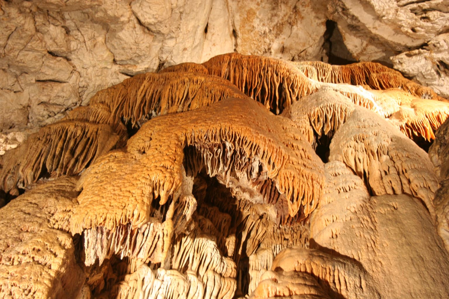
Low Tatras National Park is best known for its remarkable altitudinal diversity and the dramatic contrast between its western and eastern geological sections. The park protects one of Slovakia's most significant karst landscapes, with multiple show caves including the Demänovská Cave of Freedom and the Demänovská Ice Cave. The alpine chamois population represents a successful conservation story, with the current herd descended from individuals reintroduced from the High Tatras in the 1970s. The park encompasses the entire Low Tatras range, providing habitat for nearly all Western Carpathian mountain and alpine species, including numerous endemic and relict species. The area is also renowned for its ski resorts, particularly Jasna, making it a year-round destination.

Grassy mountain ridge with patches of snow, rocky outcrops, and distant mountain ranges under clear sky
Panoramic view from Ďumbier peak in Low Tatras National Park

Low Tatras National Park history and protected-area timeline

The protection of Low Tatras territory began with early conservation efforts between 1918 and 1921, soon after the formation of Czechoslovakia. These initial attempts established the foundational principle that this mountain range warranted formal protection. Following the Second World War, conservation advocacy resumed, building on the earlier groundwork.

A formal proposal for establishing what was then called the Central Slovakia National Park emerged in 1963. During 1965-1966, before the final proposal was completed, an alternative draft was developed under the name National Park Ďumbier, which would have included both northern and southern portions of the central Low Tatras territory. The draft was reformulated between 1967 and 1968 with the intention of establishing the national park to coincide with the 25th anniversary of the Slovak National Uprising, a significant historical event in Slovak history.

Despite this timing motivation, bureaucratic and logistical obstacles delayed establishment for another ten years. The national park was finally created in 1978 through Regulation 119/1978 of the Slovak Socialistic Republic, with an initial area of 81,095 hectares and a protection zone of 123,990 hectares. The formal protection status was published the same year through Ministry of Culture Regulation 120/1978, which established specific conditions for zone protection.

A significant boundary revision occurred on June 17, 1997, through Government Regulation No. 182/1997. This revision reduced the national park area to 72,842 hectares—a decrease of 8,253 hectares from the original designation—while adjusting the protection zone to 110,162 hectares, a reduction of 13,828 hectares. These changes reflected a recalibration of conservation priorities and boundary optimization based on nearly two decades of management experience.

Low Tatras National Park landscape and geographic character

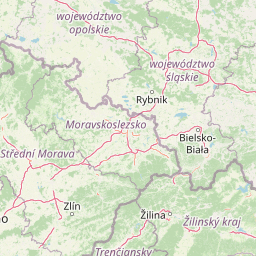
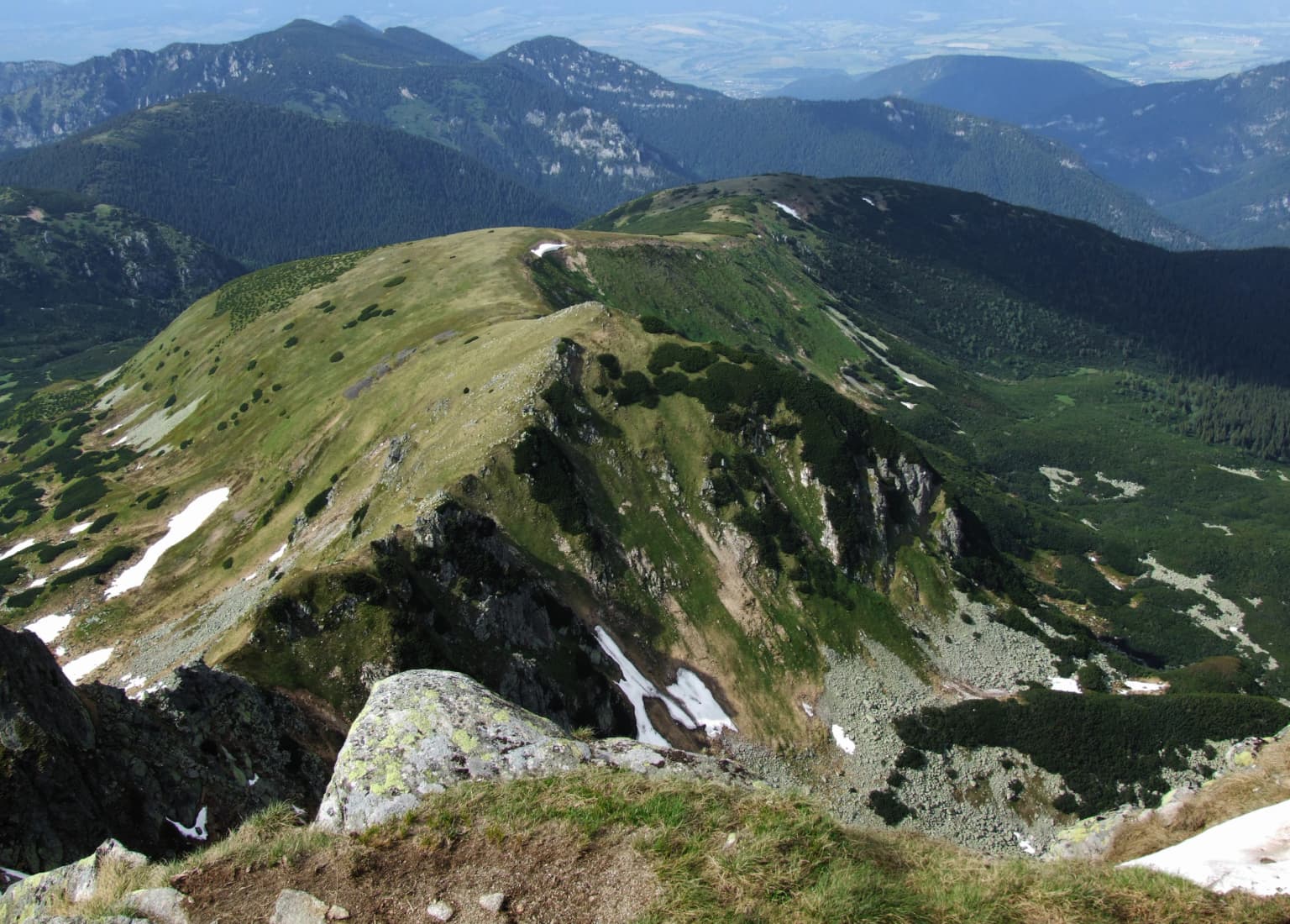
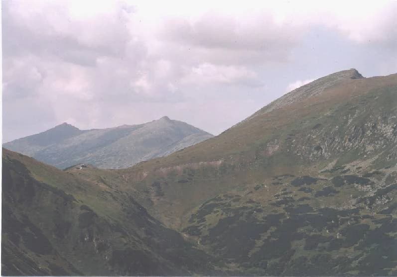
The Low Tatras mountain range presents a distinctive elongated form that dominates the central Slovak landscape. Geomorphologically, the range comprises two fundamentally different geological sections separated by the Čertovica saddle, a natural corridor that divides the mountains into distinct western and eastern portions.

The western Ďumbierske Tatry section, centered around the Ďumbier peak at 2,043 meters, belongs to the core mountain range zone (pásmo jadrových pohorí) of the Central Western Carpathians. This portion features characteristic alpine terrain with sharp ridges, steep valleys, and significant elevation differences. The eastern Kráľovohoľské Tatry section, dominated by the Kráľova hoľa peak, belongs to the Vepor zone (veporské pásmo), exhibiting somewhat different topographical characteristics while maintaining the overall alpine character.

The landscape encompasses dramatic elevation gradients from valley floors to alpine summits, with extensive forest coverage dominating the lower and middle elevations. Above approximately 1,500 meters, the terrain transitions into the kosodrevina (mountain pine) zone, characterized by dense, interwoven shrub vegetation. Limestone bedrock in certain areas, particularly around the Demänovské vrchy and Salatín, has produced significant karst topography including caves, sinkholes, and limestone cliffs.

A mountain peak with rocky slopes and grassy terrain under a partly cloudy sky
Derese peak in Low Tatras National Park

Low Tatras National Park ecosystems, habitats, and plant life

The ecological diversity of Low Tatras National Park reflects its extensive altitudinal range and varied geological substrate. Forests constitute the dominant plant community, covering roughly 70% of the total park area and providing the structural foundation for most terrestrial ecosystems within the boundary.

The mixed forest communities in the lower and middle elevations feature European beech (Fagus sylatica), white fir (Abies alba), Norway spruce (Picea abies), sycamore maple (Acer pseudoplatanus), and Norway maple (Acer platanoides), with ash (Fraxinus excelsior) in appropriate habitats. These species dominate particularly in the western and southern portions of the park, creating structurally complex forests with diverse canopy layers.

The subalpine zone beginning around 1,500 meters features extensive mountain pine (Pinus mugo) communities, locally called kosodrevina. This vegetation type has been significantly altered in many areas by historical human activity, particularly pastoral practices that reduced its former extent. Where intact, the dense, interwoven branches of mountain pine create almost impenetrable stands with limited understory development.

The limestone cliffs and scree slopes of the Demänovské vrchy and Salatín areas harbor particularly valuable floristic communities, representing typical Carpathian cliff and scree habitats. These specialized environments support relict pine forest communities with species including Scots pine (Pinus sylvestris), Slovak pasqueflower (Pulsatilla slavica), and other specialists adapted to these challenging substrates.

Wide landscape of mountain peaks and valleys under cloudy sky in Low Tatras National Park
Mountain peaks and valleys in Low Tatras National Park

Low Tatras National Park wildlife and species highlights

The fauna of Low Tatras National Park reflects the park's position as a reservoir for Western Carpathian biodiversity. The diverse habitat types, extensive forest cover, and relative inaccessibility of certain areas support populations of nearly all mountain and alpine species characteristic of the broader Carpathian region, including numerous endemic and relict species.

The most emblematic species is the Tatra chamois (Rupicapra rupicapra tatrica), a distinctive subspecies of the chamois adapted to the Carpathian mountains. The current population in the Low Tatras has been established for over 30 years and descends from approximately 30 individuals that were reintroduced from the High Tatras and Belianske Tatras during the 1970s. This reintroduction represents one of the more successful conservation translocations in Slovak mountain ecosystems.

The park provides habitat for diverse insect communities and other small invertebrates, many of which are restricted to specific habitats within the mountain environment. Larger mammals include species typical of Carpathian forests, while the avifauna includes numerous bird species associated with forest, cliff, and alpine habitats. The combination of varied topography, forest cover, and the presence of both alpine and forest environments creates conditions supporting this species richness.

Low Tatras National Park conservation status and protection priorities

Low Tatras National Park holds particular significance within Slovakia's protected area network as the country's largest national park and a critical component of national biodiversity conservation strategy. The park's extensive size and contiguity provide meaningful large-scale habitat conservation that supports ecological processes requiring broad spatial extents.

The protected area system within the park encompasses nearly 99 square kilometers of strictly protected zones, distributed across national nature reserves, nature reserves, national nature monuments, and nature monuments. This layered protection approach provides varying degrees of strictness appropriate to different conservation values and ecological sensitivities.

The four major river systems originating within the park—Váh, Hron, Hnilec, and Hornád—underscore the park's importance beyond its boundaries. These headwater catchments supply water resources for large portions of Slovakia, making watershed protection a significant dimension of the park's conservation value. The protection of these aquatic systems and their catchments supports downstream water quality and ecological integrity across extensive areas.

The successful chamois reintroduction demonstrates the potential for active conservation management to restore populations of locally extinct species. This intervention, along with ongoing monitoring and management programs, reflects the park's role as an active participant in Carpathian biodiversity conservation rather than simply a passive protected zone.

Low Tatras National Park cultural meaning and human context

The Low Tatras have historically served as a significant cultural and economic landscape for Slovak communities. The mountain valleys and foothills have supported traditional agricultural practices, including pastoral activities that shaped the landscape over centuries. These historical land uses, while creating some modification to natural vegetation patterns, also established the cultural connection between local communities and the mountain environment that persists today.

The park spans traditional settlement territories in the Banská Bystrica, Žilina, and Prešov regions, encompassing areas with distinct local cultural identities. The mountain communities in the Liptov and Horehronie regions, among others, maintain cultural traditions connected to the mountainous landscape. This human dimension adds cultural context to the purely ecological interpretation of the protected area.

Tourism infrastructure, particularly the ski resorts such as Jasna in the Demänovská dolina valley, represents a significant contemporary use pattern that interacts with the protected area. The balance between recreation and conservation remains an ongoing management consideration, with the park providing both natural asset and regulatory framework for these activities.

Top sights and standout views in Low Tatras National Park

Low Tatras National Park combines the scale of Slovakia's largest protected area with remarkable ecological and geological diversity. The dramatic Ďumbier peak at 2,043 meters provides an accessible alpine destination, while the extensive cave systems, particularly in the Demänovská valley, offer subterranean exploration opportunities. The successful chamois population, restored through deliberate reintroduction, represents a tangible conservation achievement. The park's position as the source of four major Slovak rivers demonstrates its importance beyond simple land protection. The contrast between the western Ďumbier and eastern Kráľova hoľa geological sections creates distinct landscape characters within a single protected area. The substantial forest cover and the presence of both endemic and relict species underscore the Carpathian biodiversity significance.

Best time to visit Low Tatras National Park

The Low Tatras offer meaningful visitor experiences throughout the year, with each season providing distinct character. Summer months bring optimal conditions for hiking and cave exploration, with the alpine zones accessible and the extensive trail network fully open. The forest landscapes are in full leaf, and the mountain atmosphere is generally stable. Autumn provides a different character, with autumnal coloration in the deciduous forests and fewer visitors in the more popular areas. Winter transforms the park into a significant ski destination, particularly around Jasna, where the snow sports infrastructure takes advantage of the reliable winter conditions. Spring arrives later at higher elevations and brings the transition from winter dormancy to the growing season. The shoulder seasons of late spring and early autumn often provide the best combination of accessible facilities and quieter conditions for those seeking a more contemplative mountain experience.

Park location guide

Geography guide, regional context, and park location map for Low Tatras National Park

Low Tatras National Park park geography, regions, and map view in Slovakia
Understand where Low Tatras National Park sits in Slovakia through a broader geographic reading of the surrounding landscape, nearby location context, and its mapped position within the national park landscape.

How Low Tatras National Park fits into Slovakia

Slovakia is a landlocked Central European country with a population of over 5.4 million. It became independent from Czechoslovakia in 1993 and is a member of the European Union. The country features mountainous terrain, with the Carpathian Mountains running through its territory. Bratislava serves as the capital and largest city, while Košice is the second-largest city.

Wider geography shaping Low Tatras National Park in Slovakia

Slovakia is located in Central Europe, landlocked between Poland to the north, Ukraine to the east, Hungary to the south, Austria to the west, and the Czech Republic to the northwest. The territory is mostly mountainous, with the Carpathian Mountains, including the High Tatras, dominating the northern region. The Danube River forms part of the southern border with Hungary.

Map view of Low Tatras National Park

Use this park location map to pinpoint Low Tatras National Park in Slovakia, understand its exact geographic position, and read its mapped placement within the surrounding landscape more clearly.

Pigeon | © OpenStreetMap contributors

Location context for Low Tatras National Park

Banská Bystrica RegionPrešov RegionŽilina Region

Visually understand the dramatic alpine peaks, extensive forests, and significant karst topography shaping this core Carpathian protected landscape.

Low Tatras National Park: Explore Visuals of Slovakia's Largest Mountain Protected Area
Explore a visual atlas of Low Tatras National Park, revealing its expansive mountain landscapes, deep forest zones, and distinct karst formations across central Slovakia. These high-quality images provide invaluable context for understanding the park's diverse ecosystems, crucial habitats, and the rugged, protected-area character of the Carpathian range.

Grassy mountain ridge with patches of snow, rocky outcrops, and distant mountain ranges under clear sky

Close-up view of cave formations including stalactites and stalagmites with brown and beige hues

A mountain peak with rocky slopes and grassy terrain under a partly cloudy sky

Wide landscape of mountain peaks and valleys under cloudy sky in Low Tatras National Park

Park atlas

Compare national parks and protected landscapes within Slovakia's central Carpathian mountain ranges.

Explore Other National Parks and Protected Areas Around Low Tatras National Park
Discover other national parks and protected areas surrounding Low Tatras National Park, mapping diverse mountain, forest, and karst landscapes across Central Slovakia. Browse these adjacent protected areas to compare their ecological zones and conservation strategies, gaining broader geographic context for the Carpathian region.
National parkBanská Bystrica Region

Muránska planina National Park: Discover Slovakia's Karst Plateau and Protected Natural Landscape

Explore mapped boundaries, caves, and endemic flora in Banská Bystrica Region.

Muránska planina National Park represents a significant protected landscape in central Slovakia's Banská Bystrica Region, defined by its extensive karst topography. This national park encompasses a limestone and dolomite plateau rich with geological wonders, including over 150 caves, sinkholes, and karst springs. The unique contrast between the flat plateau surface and the sharp, rocky ravines showcases a dramatic natural terrain. Explore the park's mapped boundaries and its remarkable biodiversity, highlighted by 35 endemic species and rare Tertiary relict flora like Daphne arbuscula, making it a key destination for atlas-based geographic discovery.

Area
213.18 km²
Established
1997
IUCN
II
Relief
Mountain
National park

Veľká Fatra National Park: Slovakia's Premier Protected Landscape for Geographic Discovery

Explore the park's mapped boundaries and regional natural terrain.

Veľká Fatra National Park stands as a distinct protected area, offering critical insights into Slovakia's regional geography and landscape character. This entry provides an atlas-driven perspective on its mapped boundaries and its significance as a national park. Delve into the structured geographic details and protected land context that define Veľká Fatra National Park for comprehensive discovery.

Area
403.713 km²
Established
2002
Relief
Mountain
Climate
Temperate
Watercolor painting of mountain ranges, forests, and a winding river
National parkLesser Poland Voivodeship

Tatra National Park: Poland's Premier Alpine National Park and Protected Landscape

Explore dramatic glacial terrain, mountain lakes, and regional geography.

Tatra National Park is the definitive Alpine protected area in Poland, located in Lesser Poland Voivodeship. It showcases unique glacial landforms, including over 30 mountain lakes and dramatic peaks like Rysy. This national park serves as a crucial habitat for endemic species and offers unparalleled opportunities for atlas exploration of its rugged, mapped terrain. Understand its geographic significance as part of the Carpathian Mountains and its role as a protected landscape.

Area
211.64 km²
Established
1954
IUCN
II
Visitors
3.9M annual
National park

Malá Fatra National Park National Park: Geographic Context and Protected Area Mapping

Explore the mapped terrain and regional geography.

Malá Fatra National Park serves as a cornerstone for understanding Slovakia's protected landscapes. This dedicated park page provides crucial geographic context, detailing its national park designation and the extent of its protected area boundaries. Users can leverage MoriAtlas to visualize the park's location within the broader regional geography, facilitating a structured approach to discovering its natural landscape and terrain through map-based exploration.

Area
226.3 km²
Established
1988
IUCN
II
Relief
Mountain
Watercolor illustration of a winding river through rolling green hills with trees in the foreground
National parkKošice Region

Slovak Paradise National Park: Protected Area Mapping & Geographic Context in Košice Region

Explore the boundaries and terrain of this national park.

Investigate Slovak Paradise National Park, a designated national park situated within Slovakia's Košice Region. This detailed entry provides essential context for understanding its protected landscape features, mapped geographic distribution, and role within regional atlas exploration. Discover its unique terrain and boundaries to build a comprehensive view of Slovak conservation areas.

Area
197.63 km²
Established
1988
IUCN
II
Relief
Mountain
Watercolor illustration of a river flowing through a forested valley with rolling hills and scattered trees
National parkPrešov Region

Pieniny National Park: Slovakia's Distinctive Protected Landscape and Dunajec River Gorge

Explore mapped boundaries, regional geography, and protected karst terrain.

Pieniny National Park offers a focused exploration of dramatic limestone gorges and unique Carpathian mountain geography within Slovakia's Prešov Region. This national park is celebrated for the spectacular Dunajec River Gorge, a feature that defines its protected landscape and provides a profound example of natural terrain shaping. Understanding Pieniny National Park involves appreciating its specific mapped boundaries and its role as a significant protected area within the broader atlas of European natural wonders and conservation territories.

Area
37.5 km²
Established
1967
IUCN
II
Relief
Mountain
National parkKošice Region

Slovak Karst National Park: Premier Central European Karst Landscape and Cave Systems

Explore protected terrain and mapped underground wonders in Košice Region.

Slovak Karst National Park offers an unparalleled glimpse into a dynamic karst environment. As a designated national park and UNESCO Biosphere Reserve, it preserves a significant concentration of caves, dramatic limestone formations, and rugged canyons within its territory in southeastern Slovakia. This atlas-focused presentation highlights the park's distinctive geology, mapped landscape features, and its importance as a protected natural area within the broader geography of the Košice Region. Understand the park's surface topography and its world-renowned subterranean realms.

Area
346.11 km²
Established
2002
IUCN
II
Relief
Mountain
Watercolor painting showing rolling green hills, forests, and distant mountains under a pale sky
National parkLesser Poland Voivodeship

Gorce National Park: Carpathian Forest Ecosystems and Mapped Terrain in Lesser Poland

Protected landscape discovery within the Western Beskids.

Delve into the protected landscape of Gorce National Park, a key national park situated in Poland's Lesser Poland Voivodeship. This atlas entry focuses on its mapped geography, highlighting the characteristic Carpathian mountain terrain, extensive old-growth forests, and unique alpine meadows. Understand the park's protected boundaries and its significance within the regional landscape context of the Western Beskids, providing a foundation for structured geographic exploration.

Area
70.3 km²
Established
1981
IUCN
II
Visitors
80K annual

Common questions about visiting, size, designation, and location context for Low Tatras National Park

Low Tatras National Park FAQs for park facts, access, geography, and protected area context
Find quick answers about Low Tatras National Park, including protected-area facts, park geography, trail and visitor context, and how the park fits into its surrounding country and regional landscape.
MoriAtlas Explorer

Continue Your Protected Areas Search Across the Global Atlas

Deepen your exploration by continuing the structured search for national parks and protected areas worldwide. Utilize the comprehensive filtering capabilities to compare different conservation landscapes and refine your understanding of global park geography. Discover more about the distribution and characteristics of protected natural areas.

Global natural geography