Mori Atlas logo
Country parks

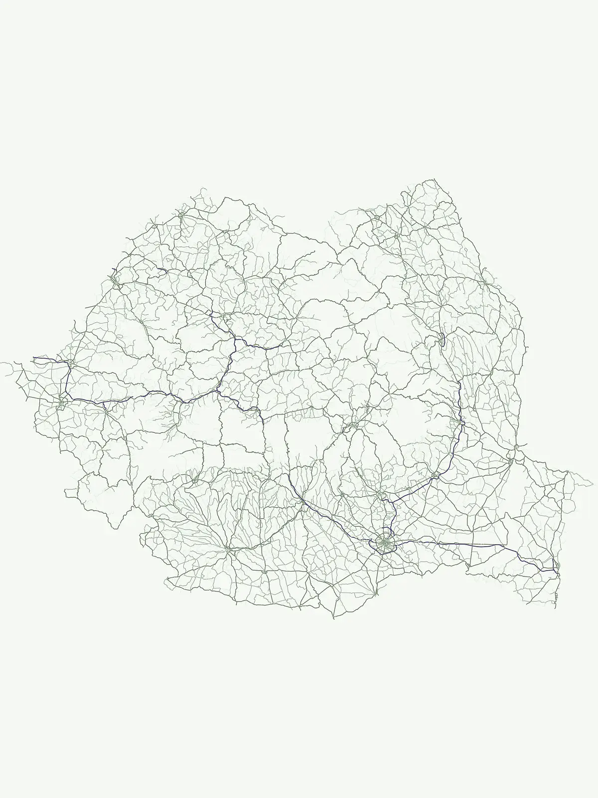
Explore the full distribution of protected landscapes and mapped natural areas across Romania.

Romania National Parks and Protected Areas: A Comprehensive Geographic Atlas and Browse List

Discover the breadth of Romania's protected lands through an expansive atlas of its national parks and nature reserves. This dedicated browse surface allows for detailed examination of park boundaries, regional geography, and the overall distribution of protected areas, providing a clear geographic context for conservation landscapes within the country. Understand how these natural areas connect across Romania's diverse terrain and Carpathian mountain ranges.

Romania National Parks and Protected Areas: A Comprehensive Geographic Atlas and Browse List

Discover the geographic spread of Romania's nature reserves and conservation areas, mapping diverse terrain.

Explore Romania's National Parks and Protected Areas: Comprehensive List and Geographic Atlas

Browse a comprehensive atlas of Romania's national parks, nature reserves, and protected landscapes, covering everything from the Carpathian Mountains to the Danube Delta wetlands and karst formations. This country-wide listing offers a structured geographic view of Romania's conservation areas, allowing you to trace the distribution of its diverse natural protected areas and understand their regional context.

Showing 1 to 20 of 31 parks

Watercolor illustration showing green mountains, pink winding path, and yellow sun against white background
Protected area

Danube Delta

Explore the mapped protected area, its unique terrain, and regional landscape context.

The Danube Delta, a protected area in Romania, presents a remarkable geography defined by its extensive wetland terrain, intricate waterways, and significant biodiversity. As Europe's largest and best-preserved river delta, it offers a unique landscape for atlas-based exploration, focusing on its mapped boundaries, regional geographic context, and its role as a critical ecological zone where the Danube River merges with the Black Sea. Understand the delta's horizontal expanse, its network of channels, and its evolving landforms within a protected landscape of global importance.

4,152 km²1998TemperateModerate access
Watercolor illustration showing a mountain with a winding path through pine trees and a snow-capped peak
National parkMountain

Piatra Craiului National Park

Explore Romania's unique national park and its mapped terrain.

Navigate the protected geography of Piatra Craiului National Park, a key national park entity. This page details its mapped boundaries and situates its natural landscape within Romania's regional geography, offering a structured point of discovery for geographic atlas enthusiasts. Understand the park's identity as a protected natural area and its contribution to the mapped terrain of the region.

147.66 km²2000IIMinor water
Watercolor painting of a mountain with a waterfall, green trees, and rocky cliffs
Protected landscapeMountain

Bucegi Natural Park

Explore its mapped boundaries and natural terrain.

As a protected landscape in Romania, Bucegi Natural Park offers a distinct focus for geographic study and atlas exploration. This detail page provides access to its mapped protected boundaries, helping users understand its specific location and regional context. Discover how this natural area contributes to the broader understanding of protected lands within the national geography. MoriAtlas enables a clear view of Bucegi Natural Park's landscape characteristics and its place within a mapped system of natural reserves.

0.327 km²2000TemperateV
Watercolor painting showing green mountains, a yellow sun, and pink clouds against a white background
National parkHunedoara CountyMountain

Retezat National Park

Mapped boundaries and landscape context in Hunedoara County.

Retezat National Park is a key protected area featured within MoriAtlas, offering structured geographic data and map-based insights. This national park's protected landscape is situated in Hunedoara County, Romania, contributing significantly to the regional topography and natural context of the Southern Carpathians. Explore its mapped boundaries and understand its role as a distinct natural entity.

380.47 km²1935AlpineII
Watercolor painting showing colorful layered rock formations with green forested areas on slopes
Protected landscapeMountain

Apuseni Natural Park

Romania's protected area mapped in its regional geography.

Apuseni Natural Park stands as a protected landscape offering significant value for geographic discovery. This entry provides a detailed look at its protected-area status and mapped landscape context within Romania. Users can explore its boundaries, understand its relation to surrounding terrain, and utilize this information for a structured atlas-based approach to natural landscape research.

757.84 km²1990TemperateModerate access
Watercolor painting showing a river winding between two green cliffs
Protected landscapeRomaniaMountain

Iron Gates Natural Park

Detailed atlas view of a protected landscape in Romania.

Uncover the geographic dimensions of Iron Gates Natural Park, a protected landscape situated in Romania. This detailed entry offers an atlas-centric exploration of its mapped boundaries and regional setting, facilitating a deeper understanding of its protected status and landscape features within the national geography. Discover the park's intrinsic value through structured geographic data and visual map context.

1,156.66 km²2000MediterraneanModerate access
Watercolor illustration of green pine trees, a mountain range with pink and gray peaks, and a pinkish valley
National parkMountain

Cheile Bicazului-Hășmaș National Park

Discover Romania's National Park mapped boundaries and regional context.

Cheile Bicazului-Hășmaș National Park represents a vital component of Romania's protected natural areas, offering rich geographic detail for atlas enthusiasts. This national park's mapped landscape and defined protected boundaries provide essential context for understanding regional geography and conservation efforts. Explore the specific identity of this protected terrain and its significance within the broader Romanian atlas.

65.75 km²IIMinor water
Watercolor illustration showing a winding path through a forested mountain landscape with flowers and trees
National park

Semenic-Cheile Carașului National Park

National Park Geography and Mapped Boundaries

Delve into Semenic-Cheile Carașului National Park, a protected landscape in Romania, with a focus on its atlas and geographic context. This page details the park's identity as a national park, its specific mapped boundaries, and its contribution to regional geographic understanding. Utilize MoriAtlas to explore the structured data that defines this protected area and its surrounding natural terrain, enhancing your comprehension of Romania's conservation landscapes.

II
National parkMountain

Rodna Mountains National Park

Discover the mapped terrain and protected area context.

Rodna Mountains National Park represents a key protected landscape within Romania, offering rich opportunities for geographic discovery. This page provides detailed insight into its mapped boundaries and how it integrates into the regional terrain. Delve into the structured atlas data to understand the park's protected area status and its significance within the natural geography.

II
Watercolor illustration of mountains, a winding river, and forested hills under a sunset sky
National parkMountain

Domogled-Valea Cernei National Park

Explore its protected boundaries and regional geography.

Domogled-Valea Cernei National Park is recognized as a National Park, offering a distinct protected landscape for atlas-based discovery. This page provides focused insights into its mapped geographic extent and the character of its natural terrain. Understand the park's role within Romania's protected areas network and its unique geographic identity. Utilize this structured view to navigate the park's features and its surrounding landscape context for informed exploration.

612.11 km²2000IIMajor water bodies
National parkRomaniaMountain

Nera Gorge-Beușnița National Park

Explore the mapped geography of this protected Romanian landscape.

Nera Gorge-Beușnița National Park offers a detailed view of a protected karst canyon, featuring the Nera River's dramatic gorge and the picturesque Beușnița waterfalls. This protected area in Romania provides valuable context for understanding karst terrain, subterranean systems, and the geographic distribution of protected lands within the Balkan region. Users can explore its distinct landscape features and their place within Romania's atlas of natural protected areas.

IIMajor water bodies
National parkMountain

Călimani National Park

Explore mapped boundaries and regional geographic context.

Uncover the geographic identity of Călimani National Park, a designated national park in Romania. This resource offers detailed insights into its protected landscape, mapped terrain, and surrounding natural context. Navigate through its specific park boundaries and understand how it fits into the wider regional geography, providing a clear atlas-style overview for dedicated discovery.

240.41 km²2000IIMinor water
Watercolor painting of green hills, distant mountains, and a winding river under a soft sky.
Protected landscapeMaramureș CountyMountain

Maramureș Mountains Natural Park

Explore the mapped boundaries and dramatic terrain of Romania's largest nature park.

Delve into the Maramureș Mountains Natural Park, a protected landscape covering extensive tracts of the northern Carpathian Mountains. This page provides detailed geographic context, showcasing the park's mapped boundaries, diverse alpine terrain, and its role within the broader regional geography of Maramureș County. Understand the natural features and protected area significance of this expansive Carpathian wilderness for structured atlas exploration.

1,488.5 km²2004BorealModerate access
Watercolor painting showing a mountain range with a winding path and its reflection in a body of water
Protected areaTulcea CountyMountain

Măcin Mountains

Explore mapped boundaries and regional geography

Delve into the Măcin Mountains, a protected area located in Tulcea County. This detailed entry provides essential geographic information, focusing on its mapped boundaries and the surrounding natural landscape. MoriAtlas offers a structured approach to understanding this protected land's position within the regional geography, empowering users to explore its unique characteristics through a lens of atlas-driven discovery and conservation context.

113.21 km²TemperateIIMinor water
A watercolor painting showing green hills, four trees, and a pastel sky with pink and yellow hues
Protected areaRomania

Hațeg Country Dinosaur Geopark

Explore the protected landscape and regional atlas context.

Discover the Hațeg Country Dinosaur Geopark, a distinct protected area situated within the rich geography of Romania. This entry provides detailed information on its mapped boundaries and landscape characteristics, serving as a crucial anchor for understanding its place in the Southeast European region. Explore the structured geographic data and atlas context that define this significant protected landscape.

V
Watercolor illustration of green hills, a single tree, and a lake
National parkVâlcea CountyMountain

Cozia National Park

Discover the mapped protected area in Romania's landscape.

Cozia National Park is a key national park situated within Vâlcea County, Romania. This page facilitates the exploration of its protected landscape, offering detailed insights into its geographic context and mapped features. Understand how Cozia National Park contributes to the regional geography and atlas of Romania's protected areas, providing a foundation for structured landscape discovery.

171 km²2000AlpineII
Watercolor illustration showing a winding path through green forest with mountains in the background
National parkGorj CountyMountain

Defileul Jiului National Park

Explore maps, geography, and protected area context.

Defileul Jiului National Park is a vital protected natural area situated in Gorj County, Romania. This MoriAtlas page serves as a detailed entry point for understanding the park's specific geography, its mapped perimeters, and its significance within the regional landscape atlas. Discover the park's topographic features and its relationship to the surrounding terrain of the Southern Carpathians, providing essential context for geographic exploration.

111.27 km²2005IIMinor water
Watercolor illustration showing a mountain with green and pink hues surrounded by pine trees
National parkVâlcea CountyMountain

Buila-Vânturarița National Park

Mapped protected landscape within Vâlcea County.

Delve into the specifics of Buila-Vânturarița National Park, a designated national park in Vâlcea County, Romania. This detailed entry focuses on its protected landscape identity and geographic placement, offering precise mapped boundary information relevant for atlas exploration. Understand how this national park contributes to the regional geography and protected area network, providing a foundational element for structured discovery of Romania's natural environments.

41.86 km²2005TemperateModerate access

Protected landscapeHunedoara CountyMountain

Grădiștea Muncelului-Cioclovina Natural Park

Explore protected area geography and mapped boundaries.

Gain a structured understanding of Grădiștea Muncelului-Cioclovina Natural Park, a significant protected landscape located in Romania's Hunedoara County. This resource details its geographic position and mapped protected area extent, providing essential context for atlas exploration and regional landscape analysis. It serves as a focused entry point for understanding the park's unique geographic identity within its natural setting.

381.84 km²2000VMinor water
Protected landscapeNeamț County

Vânători-Neamț Natural Park

Mapped protected area and regional landscape context.

Vânători-Neamț Natural Park is a designated protected landscape located in Romania's Neamț County. This MoriAtlas entry provides detailed geographic information, focusing on the park's mapped boundaries and its role within the regional atlas of protected natural areas. Understand the park's specific landscape context and its place within the wider geography of Western Moldavia, essential for any structured exploration of Romanian protected lands.

306.31 km²2003VMinor water
Other countries

Explore Diverse Protected Landscapes Across Central and Southeast Europe, comparing adjacent country park geographies.

Discover National Parks and Protected Areas Beyond Romania's Borders

After exploring Romania's protected areas, delve into national parks and conservation landscapes across neighboring countries like Ukraine, Hungary, Serbia, Bulgaria, and Moldova. This extensive country-level atlas view provides crucial geographic context for comparing diverse protected ecosystems and understanding regional conservation efforts.

Ukraine National Parks and Protected Areas: Browse Mapped Landscapes

MoriAtlas facilitates a detailed geographic exploration of Ukraine's national parks and protected areas. This destination provides a structured overview of the country's conservation landscapes, allowing users to visually grasp their distribution and regional context. Understand the breadth of Ukraine's natural heritage through an atlas lens, supporting discovery of its unique geography and protected territories.

48 parks

Serbia National Parks and Protected Areas: Mapped Landscape Exploration

Discover the protected areas and national parks within Serbia through a structured geographic atlas interface. MoriAtlas details the mapped landscapes and regional natural terrain, allowing users to explore the full scope of conservation efforts across the country. Understand how protected lands are situated within the broader Serbian geography, facilitating a deeper, map-aware approach to natural landscape discovery.

16 parks

Hungary's National Parks and Protected Areas: A Mapped Geographic Overview

Navigate Hungary's protected natural areas through a structured geographic lens. MoriAtlas visualizes national parks and conservation landscapes, enabling users to understand their distribution across the Carpathian Basin. Discover key protected territories and their regional context for a comprehensive atlas-based exploration of Hungary's natural heritage.

13 parks

Slovakia National Parks and Protected Areas: Mapped Geographic Exploration

Delve into the structured atlas of Slovakia's national parks and protected areas. This page offers a geographically organized perspective, highlighting the distribution of protected lands and natural landscapes across the country. Understand the regional context and mapped boundaries of Slovakia's significant natural territories, providing a foundation for detailed geographic discovery and comparative exploration.

9 parks

North Macedonia National Parks and Protected Areas: Geographic Atlas Overview

Navigate the protected natural areas of North Macedonia through a structured geographic lens. This atlas view highlights the distribution and mapped boundaries of the country's national parks and significant protected lands. Understand the landscape context and regional significance of these conserved territories, essential for any map-based exploration of North Macedonia's natural heritage.

4 parks

Bosnia and Herzegovina: National Parks and Protected Lands Map Overview

Delve into the protected natural areas of Bosnia and Herzegovina, a key Balkan country. This resource provides a structured view of national parks and other conservation landscapes, emphasizing their geographic distribution and regional context. Understand the mapped boundaries and terrain of these important natural territories, offering a comprehensive atlas-style exploration for geographic understanding.

4 parks

Bulgaria National Parks and Protected Areas: Mapped Geographic Context

Access a structured overview of Bulgaria's national parks and protected areas. This atlas-focused resource highlights geographic distributions and mapped boundaries, enabling comprehensive discovery of the country's diverse natural terrain and conservation landscapes.

3 parks

Moldova National Parks and Protected Areas: Mapped Geographic Context and Distribution

MoriAtlas provides a comprehensive atlas view of Moldova's protected areas and national parks. Delve into the geographic structure, understand the distribution of natural reserves, and examine the landscape context for each protected region within the country. This resource enables detailed map-based discovery and a structured understanding of Moldova's natural heritage.

1 park

Protected area types

Continue Exploring Romania's Designation-Led Protected Areas and Natural Landscapes

Deepen your understanding of Romania's geographic context by examining its protected area classification system. Each designation represents a distinct aspect of the country's natural landscapes, offering pathways into specific details about park boundaries and regional geography. Continue your atlas exploration by navigating through Romania's represented protected-area categories to uncover the breadth of its natural heritage.

Romania Protected Area Designations
MoriAtlas Explorer

Continue Exploring Romania's National Park and Protected Area Geography

Deepen your understanding of Romania's conservation landscapes by continuing this focused search. Utilize advanced filtering options to compare protected areas and map their distribution across the country. This refined approach to discovering Romania's natural heritage provides clear geographic context and sets the stage for detailed investigation into its unique park systems.

Global natural geography